


Description
App Information Free Nautical Charts
- App NameFree Nautical Charts
- Package Namecom.marineways.android
- UpdatedMarch 14, 2017
- File SizeUndefined
- Requires AndroidAndroid 4.0 and up
- Version1.0.9
- DeveloperArpeggio
- Installs10,000 - 50,000
- PriceFree
- CategoryTravel & Local
- Developer
- Google Play Link
Free Nautical Charts Version History
Select Free Nautical Charts Version :-
Free Nautical Charts 1.14 APK File
Publish Date: 2018 /12/22Requires Android: Android 4.0+ (Ice Cream Sandwich, API: 14)File Size: 2.6 MBTested on: Android 8.1 (Oreo, API: 27)File Sha1: b07f673aa2a6f6a00c57c7baf15cf0946d6571e9 -
Free Nautical Charts 1.0.9 APK File
Publish Date: 2017 /3/20Requires Android: Android 4.0+ (Ice Cream Sandwich, API: 14)File Size: 3.3 MBTested on: Android 5.1 (Lollipop, API: 22)File Sha1: ec7254eb6d41e09cee864039fa19243d3f4a4b9b -
Free Nautical Charts 1.0 APK File
Publish Date: 2016 /3/23Requires Android: Android 4.0+ (Ice Cream Sandwich, API: 14)File Size: 3.6 MBTested on: Android 5.1 (Lollipop, API: 22)File Sha1: 6fbb03c7a7b33ee51f71a08e8ac3ca57f084e24c
Arpeggio Show More...

Free Nautical Charts 1.0.9 APK
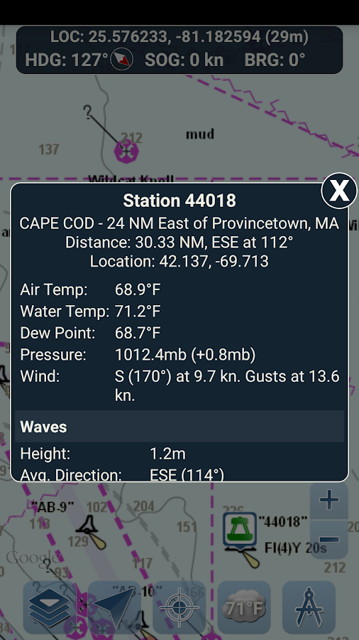
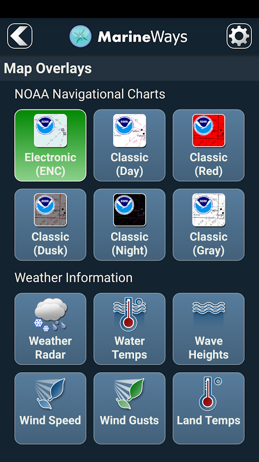
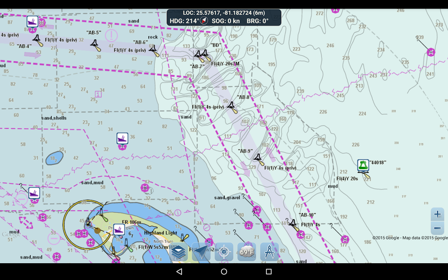
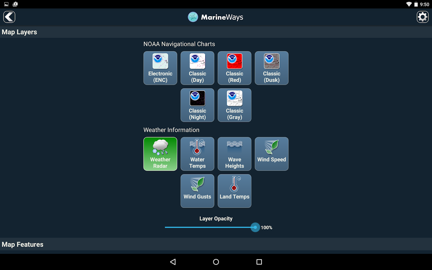
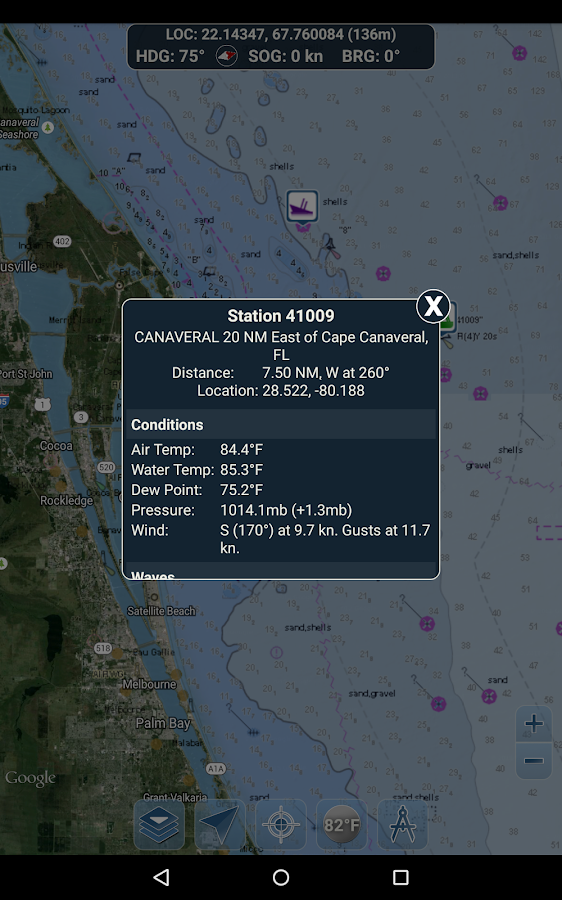
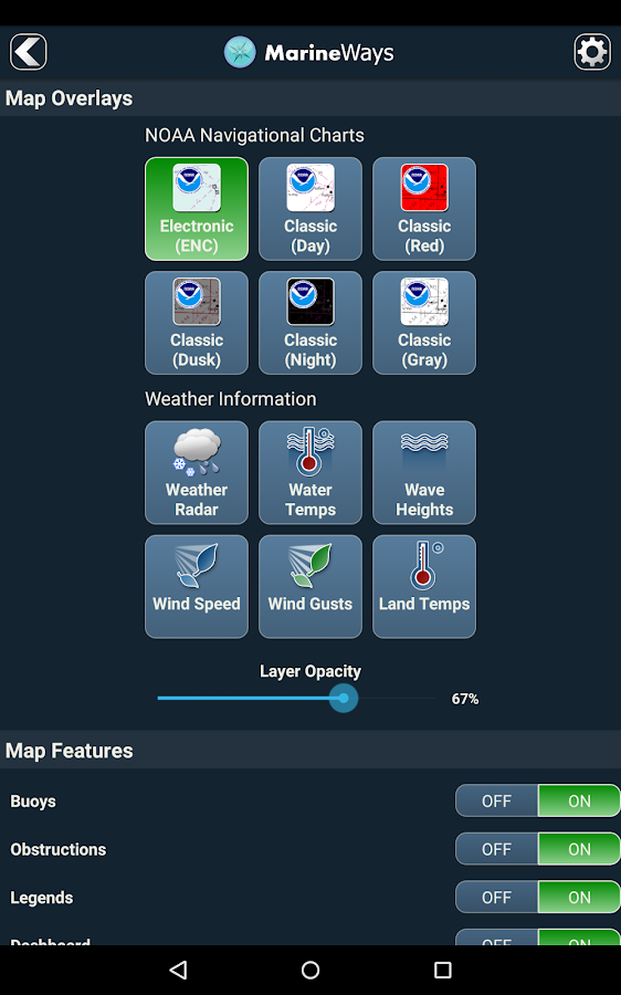
Marine Ways Boating is the ultimate marinenavigation and planning application! In this application you willgain access to:FREE NAVIGATIONAL CHARTS- NOAA ENC Electronic Navigational Charts (NOAA's newest and mostpowerful electronic charting product)- NOAA BSB Classic Raster Charts (including Day, Red, Dusk, Night,and Gray versions)- All chart data is supplied by NOAA.Just toggle the chart you want in the map settings section and itwill show up on the map! Zoom in for the finest detail!ROUTE PLANNING TOOLS-Route Plotting. Tap and hold on the map for one second to plotyour waypoints. To form a route, continue to tap and hold on themap in different areas. Distance and bearing are convenientlycalculated and displayed for each leg as you add, adjust, or removewaypoints.-Travel Mode. Automatically centers the map on your currentposition as you move. Use travel mode to see how closely you arefollowing your plotted route in real time!-Route Leg Summary. A convenient view containing detailedinformation of each leg you have plotted, including start and endcoordinates, distance, and bearing.BUOY REPORTS AND OBSTRUCTION INFORMATIONMarkers for buoys and obstructions are conveniently plotted intheir actual location on the map! Just click on the marker to viewtheir information!- Buoy Reports: Get complete current conditions and wave reportsfor fixed and drifting buoys.- Obstructions: Get location and history information aboutpotentially dangerous, submerged hazards including rocks and sunkenvessels.NAVIGATION DASHBOARDThe navigational dashboard shows various real-time informationincluding:- Current location (latitude and longitude, with accuracyrange)- Current Heading (includes a small directional compass aswell!)- Current Speed Over Ground- Current BearingMARINE MAP OVERLAYSToggle various marine overlay data right onto the map to get abetter idea of the current boating conditions!Overlays include:- Water Surface Temperature (Global)- Wind Speeds (US only)- Wind Gusts (US only)- Wave Heights (US only)LOCATION SHARING OVER WATER / VIEW OTHER BOATS- Display your last known location, speed, bearing, and boat nameon the map for other Marine Ways boaters to view.- View the last known location, speed, bearing, and boat name ofother Marine Ways boaters, as well as their distance and bearingfrom your location.- Location sharing is turned off by default. When you are ready toshare, toggle it on within general settings. To continuously updateyour location on the map, keep the app opened and focused. The appcurrently does not update your location in the background.WEATHER INFORMATION- Weather Precipitation Radar (US & Hawaii only). Detects anyrain and snow in the area.- Weather Station. Reports the nearest observation station data.Current temperature, humidity, weather conditions, wind, and more!Station observation data is available globally.- Weather Alerts. Weather station also reports any active weatheralerts issued by the National Weather Service such as severethunderstorm warnings or hurricane warnings. Weather alertinformation is available for US, Alaska and Hawaii.- Land Surface Temperature overlay. Shows the current surfacetemperature on land (US only).Before using this application, please read and agree to thefollowing terms of use / service and privacy policy:Terms of Use / Service: http://www.marineways.com/apptermsPrivacy policy: http://www.marineways.com/appprivacyNavigational Charts Disclaimer from NOAA:NOAA ENC Online is not certified for navigation. Screen captures ofthe ENCs displayed here do NOT fulfill chart carriage requirementsfor regulated commercial vessels under Titles 33 and 46 of the Codeof Federal Regulations.Enjoy the app! Marine Ways is also available on the web athttp://www.marineways.com
Similar Apps Show More...

Boating 8.1 APK
The world's most popular marine & lakesapp! A favorite among cruisers, sailors, fishermen and divers. Findthe same detailed charts as on the best GPS plotters. Download theapp, then go to Menu>Shop and select your region to get a 14-dayfree trial to the overwhelming value of Navionics+.If you have a tablet, please search our HD app.NAVIONICS+ includes:√ Download of the following chart layers that will reside onyour device even after expiration:- NAUTICAL CHART for all essential cartographic reference detail.The most accurate and thorough set of information based onHydrographic Office data, Notices to Mariners, new publications,our own surveys, and reports from users. It provides port plans,safety depth contours, marine services info, tides & currents,navigation aids and more.- SONARCHART™: the award-winning 1 ft/ 0,5 m HD bathymetry map thatreflects ever-changing conditions. Be part of the community andcontribute by uploading your sonar logs to enhance it.- COMMUNITY EDITS made by users (rocks, wrecks, etc.) and sharedfor all to benefit.√ CHART UPDATES: we deliver more than 2,000 updates every day!Take advantage of our updates as frequently as you like.√ ADVANCED MAP OPTIONS to highlight Shallow Areas, and filterDepth Contours. Includes a Fishing Mode that enables Fishing Rangefor targeting key fishing areas.√ NAVIGATION MODULE for advanced route planning with ETA,distance to arrival, heading to WP, fuel consumption and more!√ DOCK-TO-DOCK AUTOROUTING quickly creates detailed routes eventhrough narrow waterways and channels, based on chart data andnavigation aids. POIs are automatically shown nearby yourdestination.√ WEATHER & TIDES provides real-time weather data andforecasts. Access daily and hourly forecasts for your favoritelocations and get wind, weather buoys, Tides & Currentsoverlaid on your map. Buoy data is retrieved from NOAA and caninclude wind speed, gust and direction as well as air pressure,water temperature, wave height and other relevant marine data.Note: Download detailed maps by zooming in or fromMenu>Download Map. Check navionics.com for coverage.Navionics+ is a one year subscription. At expiration you can renewwith a discount of up to 50%. If you don’t renew, you can still usethe charts you previously downloaded, along with several freefeatures:- TRACK your journey, view speed, distance, time and COG. Save toarchive, see stats and playback.- ROUTES: create and edit, based on speed and fuelconsumption.- Measure DISTANCE, add MARKERS, get WIND FORECASTS and sun/mooncycles.- MAP OPTIONS: Satellite/Terrain, adjust shorelines to selectedWater Level, choose Depth Shading and Easy View to begin.- SYNC Tracks, Routes & Markers among your mobiledevices.- MAGAZINES & GUIDES for location-based articles from leadingindustry publishers.- SONARCHART ™ LIVE - allows you to create new personal 1ft/0.5 mHD bathymetry maps that display in real time while navigating.Upload your sonar logs to build even better local charts for yourarea connecting wirelessly to a compatible sounder/plotter.- PLOTTER SYNC - Compatible Wi-Fi enabled plotter owners cantransfer routes and markers, activate and update their eligibleplotter card and upload sonar logs for improved SonarChart™! Learnmore at www.navionics.com/en/plotter-syncNavionics has certified several Android models where the app isdesigned to load and operate correctly with an OS of 4.0 or higher.Please refer to our Compatibility Guide, which is continuouslyupdated at http://www.navionics.com/en/compatibility/mobile. Wecannot guarantee flawless operation or provide support fornon-certified devices.ALL SALES ARE FINAL on Google Play.


Boating USA 8.2.1 APK
The world's most popular marine & lakesapp! A favorite among cruisers, sailors, fishermen and divers. Findthe same detailed charts as on the best GPS plotters. This appincludes the overwhelming value of Navionics+. Alternatively, youmay have found a free version on the store offering basic features,where Navionics+ can be purchased In-App. If you have a tablet,please search our HD app.NAVIONICS+ includes:√ Download of the following chart layers that will reside on yourdevice even after expiration:-NAUTICAL CHART for all essential cartographic reference detail.The most accurate and thorough set of information based onHydrographic Office data, Notices to Mariners, new publications,our own surveys, and reports from users. It provides port plans,safety depth contours, marine services info, tides & currents,navigation aids and more.-SONARCHART™: the award-winning 1 ft/0.5m HD bathymetry map thatreflects ever-changing conditions. Be part of the community andcontribute by uploading your sonar logs to enhance it.-COMMUNITY EDITS made by users (rocks, wrecks, etc.) and shared forall to benefit.√ CHART UPDATES: we deliver more than 2,000 updates every day! Takeadvantage of our updates as frequently as you like.√ DOCK-TO-DOCK AUTOROUTING quickly creates detailed routes eventhrough narrow waterways and channels, based on chart data andnavigation aids. POIs are automatically shown nearby yourdestination.√ NAVIGATION MODULE for advanced route planning with ETA, distanceto arrival, heading to WP, fuel consumption and more!√ ADVANCED MAP OPTIONS: overlay Satellite/Terrain, highlightShallow Areas, filter Depth Contours and enable a Fishing Range totarget key fishing areas.√ PLOTTER SYNC - Compatible Wi-Fi enabled plotter owners cantransfer routes and markers, activate and update their eligibleplotter card and upload sonar logs for improved SonarChart™! Learnmore at www.navionics.com/en/plotter-sync√ WEATHER & TIDES provides real-time weather data andforecasts. Access daily and hourly forecasts for your favoritelocations and get wind, weather buoys, Tides & Currentsoverlaid on your map. Buoy data from NOAA can include wind speed,gust and direction as well as air pressure, water temperature, waveheight and other relevant marine data.Note: Download detailed maps by zooming in or from Menu>DownloadMap. Check navionics.com for coverage.Navionics+ is a one year subscription. At expiration, you can renewwith a discount of up to 50%. If you don’t renew, you can still usethe charts you previously downloaded, along with several freefeatures:TRACK your journey, view speed, distance, time and COG.ROUTES: create and edit, based on speed and fuel consumptionMeasure DISTANCE, add MARKERS, get WIND FORECASTS and sun/mooncyclesMAP OPTIONS: adjust shorelines to selected Water Level, chooseDepth Shading and Easy View (not on Govt. Charts)SYNC Tracks, Routes & Markers among your mobile devicesMAGAZINES & GUIDES for location-based articles.GOVT. CHART in USSONARCHART™ LIVE - allows you to create new personal 1ft/0.5 m HDbathymetry maps that display in real time while navigating. Uploadyour sonar logs to build even better local charts for your areaconnecting wirelessly to a compatible sounder/plotter.COVERAGEDoes not include Bermuda, which can be found on Boating Caribbean& South America. Visit navionics.com for the lake list.Navionics has certified several Android models where the app isdesigned to load and operate correctly with an OS of 4.0 or higher.Please refer to our Compatibility Guide, which is continuouslyupdated at http://www.navionics.com/en/compatibility/mobile. Wecannot guarantee flawless operation or provide support fornon-certified devices. ALL SALES ARE FINAL on Google Play.

Boating HD 8.0.1 APK
The world's most popular marine &lakesapp! A favorite among cruisers, sailors, fishermen and divers.Findthe same detailed charts as on the best GPS plotters. Downloadtheapp, then go to Menu>Charts and select your region to get a14day free trial to the overwhelming value of Navionics+.NAVIONICS+ includes:√ Download of the following chart layers that will reside onyourdevice even after expiration:- NAUTICAL CHART for all essential cartographic referencedetail.The most accurate and thorough set of information basedonHydrographic Office data, Notices to Mariners, newpublications,our own surveys, and reports from users. It providesport plans,safety depth contours, marine services info, tides ¤ts,navigation aids and more.- SONARCHART™: the award-winning 1 ft/ 0,5 m HD bathymetry mapthatreflects ever-changing conditions. Be part of the communityandcontribute by uploading your sonar logs to enhance it.- COMMUNITY EDITS made by users (rocks, wrecks, etc.) and sharedforall to benefit.√ CHART UPDATES: we deliver more than 2,000 updates every day!Takeadvantage of our updates as frequently as you like.√ ADVANCED MAP OPTIONS to highlight Shallow Areas, and filterDepthContours. Includes a Fishing Mode that enables Fishing Rangefortargeting key fishing areas.√ NAVIGATION MODULE for advanced route planning with ETA,distanceto arrival, heading to WP, fuel consumption and more!√ DOCK-TO-DOCK AUTOROUTING quickly creates detailed routeseventhrough narrow waterways and channels, based on chart dataandnavigation aids. POIs are automatically shown nearbyyourdestination.√ WEATHER & TIDES provides real-time weather data andforecasts.Access daily and hourly forecasts for your favoritelocations andget wind, weather buoys, Tides & Currentsoverlaid on yourmap.Buoy data is retrieved from NOAA and can include wind speed,gustand direction as well as air pressure, water temperature,waveheight and other relevant marine data.Note: Download detailed maps by zooming in orfromMenu>Download Map. Check navionics.com for coverage.Navionics+ is a one year subscription. At expiration you canrenewwith a discount of up to 50%. If you don’t renew, you canstill usethe charts you previously downloaded, along with severalfreefeatures:TRACK your journey, view speed, distance, time and COG. Savetoarchive, see stats and playbackROUTES: create and edit, based on speed and fuel consumptionMeasure DISTANCE, add MARKERS, get WIND FORECASTS andsun/mooncyclesMAP OPTIONS: Satellite/Terrain, adjust shorelines to selectedWaterLevel, choose Depth Shading and Easy View to beginSYNC Tracks, Routes & Markers among your mobile devicesMAGAZINES & GUIDES for location-based articles fromleadingindustry publishersSONARCHART ™ LIVE - allows you to create new personal 1ft/0.5 mHDbathymetry maps that display in real time while navigating.Uploadyour sonar logs to build even better local charts for yourareaconnecting wirelessly to a compatible sounder/plotter.PLOTTER SYNC - NEW! Plotter Sync may also provide accesstoDock-to-dock Autorouting, SonarChart Live and Advanced MapOptionsfor your GPS plotter. Learn moreatwww.navionics.com/en/plotter-syncNavionics has certified several Android models where the appisdesigned to load and operate correctly with an OS of 4.0 orhigher.Please refer to our Compatibility Guide, which iscontinuouslyupdated athttp://www.navionics.com/en/compatibility/mobile. Wecannotguarantee flawless operation or provide support fornon-certifieddevices. ALL SALES ARE FINAL on Google Play.


MX Mariner - Marine Charts APK
MX Mariner is a basic mobile marine navigator/ chart plotter featuring quilted offline raster marinecharts.Offline raster marine charts are are available for the US, NewZealand, Brazil, and UK.US, New Zealand and Brazil chart regions are free to download andupdate.UK chart regions are available for the United Kingdom, Ireland andChannel Islands as in-app purchases. Each UK chart region in-apppurchase gives you 1 year of free chart updates. UK chart regionsin MX Mariner are "derived in part from material obtained from theUK Hydrographic Office".Features:Offline raster marine chartsOnline satellite and road mapsGPS NavigationActiveCaptain interactive cruising guidebookhttps://activecaptain.com/Waypoints - create, edit, navigateTracks - record, editRoutes - create, edit, navigateGPX import / exportConfigurable units of measure and the World Magnetic ModelPlease see https://mxmariner.com/#/manual for details.

Boating US&Canada 8.2.1 APK
The world's most popular marine & lakesapp! A favorite among cruisers, sailors, fishermen and divers. Findthe same detailed charts as on the best GPS plotters. This appincludes the overwhelming value of Navionics+. Alternatively, youmay have found a free version on the store offering basic features,where Navionics+ can be purchased In-App. If you have a tablet,please search our HD app.NAVIONICS+ includes:√ Download of the following chart layers that will reside on yourdevice even after expiration:-NAUTICAL CHART for all essential cartographic reference detail.The most accurate and thorough set of information based onHydrographic Office data, Notices to Mariners, new publications,our own surveys, and reports from users. It provides port plans,safety depth contours, marine services info, tides & currents,navigation aids and more.-SONARCHART™: the award-winning 1 ft/0.5m HD bathymetry map thatreflects ever-changing conditions. Be part of the community andcontribute by uploading your sonar logs to enhance it.-COMMUNITY EDITS made by users (rocks, wrecks, etc.) and shared forall to benefit.√ CHART UPDATES: we deliver more than 2,000 updates every day! Takeadvantage of our updates as frequently as you like.√ DOCK-TO-DOCK AUTOROUTING quickly creates detailed routes eventhrough narrow waterways and channels, based on chart data andnavigation aids. POIs are automatically shown nearby yourdestination.√ NAVIGATION MODULE for advanced route planning with ETA, distanceto arrival, heading to WP, fuel consumption and more!√ ADVANCED MAP OPTIONS: overlay Satellite/Terrain, highlightShallow Areas, filter Depth Contours and enable a Fishing Range totarget key fishing areas.√ PLOTTER SYNC - Compatible Wi-Fi enabled plotter owners cantransfer routes and markers, activate and update their eligibleplotter card and upload sonar logs for improved SonarChart™! Learnmore at www.navionics.com/en/plotter-sync√ WEATHER & TIDES provides real-time weather data andforecasts. Access daily and hourly forecasts for your favoritelocations and get wind, weather buoys, Tides & Currentsoverlaid on your map. Buoy data from NOAA can include wind speed,gust and direction as well as air pressure, water temperature, waveheight and other relevant marine data.Note: Download detailed maps by zooming in or from Menu>DownloadMap. Check navionics.com for coverage.Navionics+ is a one year subscription. At expiration, you can renewwith a discount of up to 50%. If you don’t renew, you can still usethe charts you previously downloaded, along with several freefeatures:TRACK your journey, view speed, distance, time and COG.ROUTES: create and edit, based on speed and fuel consumptionMeasure DISTANCE, add MARKERS, get WIND FORECASTS and sun/mooncyclesMAP OPTIONS: adjust shorelines to selected Water Level, chooseDepth Shading and Easy View (not on Govt. Charts)SYNC Tracks, Routes & Markers among your mobile devicesMAGAZINES & GUIDES for location-based articles.GOVT. CHART in USSONARCHART™ LIVE - allows you to create new personal 1ft/0.5 m HDbathymetry maps that display in real time while navigating. Uploadyour sonar logs to build even better local charts for your areaconnecting wirelessly to a compatible sounder/plotter.COVERAGEDoes not include Bermuda, which can be found on Boating Caribbean& South America. Visit navionics.com for the lake list.Navionics has certified several Android models where the app isdesigned to load and operate correctly with an OS of 4.0 or higher.Please refer to our Compatibility Guide, which is continuouslyupdated at http://www.navionics.com/en/compatibility/mobile. Wecannot guarantee flawless operation or provide support fornon-certified devices. ALL SALES ARE FINAL on Google Play.

Travel & Local Top Show More...

Flightradar24 - Flight Tracker 6.7.1 APK
Turn your phone or tablet into anairtrafficradar and see planes around the world move in real-timeonadetailed map. Or point your Android device at a plane in theskytofind out where it’s going and more. Discover today whymillionsarealready using Flightradar24 - Flight Tracker.Features that have helped make Flightradar24 - FlightTrackerthe#1 selling app in 100+ countries and the #1 Travel appin140+countries (United States, France, United Kingdom, Germanyandmore)include:* Watch planes move in real-time on detailed map* Identify planes flying overhead by simply pointing yourdeviceatthe sky (the augmented reality view requiresrearcamera,accelerometer & magnetic sensor)* Experience what the pilot of a an aircraft sees in real-timeandin3D* Tap on a plane for comprehensive flight andaircraftinformationsuch as route, estimated time of arrival, actualtime ofdeparture,aircraft type, speed, altitude, andhigh-resolutionpicture* Easy to search for individual flights using flightnumber,airport,or airline* Easy to filter by airline, aircraft, altitude,speed,andmore* Easy to set bookmarks to enable quick navigation toareasofinterest* Turn the device into the arrivals and departures board ofanymajorairport and get real-time status updates for flightspluscurrentairport weather conditions (in-app purchase)* Realistic aircraft symbols (in-app purchase)* Set up custom alerts based on airline, aircraft type,flightnumberor registration (in-app purchase)HOW IT WORKSMost aircraft are equipped with so called ADS-Btranspondersthattransmit positional data. Flightradar24 has arapidlygrowingnetwork of several thousand ground stations aroundthe worldtoreceive this data that then shows up as aircraft movingon a mapinthe app. In an expanding number of regions Flightradar24,withthehelp of multilateration, is able to calculate thepositionsofaircraft that don’t have ADS-B transponders.Traditional radar data is also used in the app thanks toadirectfeed from the US Federal Aviation Administration (FAA).http://www.flightradar24.com/how-it-works***IMPORTANT NOTICES***Minimum required screen resolution is 320x480px.If you are only interested in tracking air traffic inaspecificregion, we suggest that you checkFlightradar24.comBEFOREpurchasing the app. Flightradar24 providesunrivaledpositionalaircraft data coverage around the world butthere areareas wherewe don’t have coverage.Overview of coverage as of January 2016:* Europe: close to 100%* North America: 100% of US and Canada via slightlydelayedradardata. Real-time coverage for most of US, Canada andMexicoforADS-B equipped aircraft* South America: Substantial coverage in mostcountriesincludingArgentina, Bolivia, Brazil, Chile, Colombia,EcuadorandVenezuela.* Asia: Substantial coverage in most major AsiancountriesincludingJapan, India, Indonesia, South Korea, Thailand,UAE,Malaysia,Taiwan and many other countries. Rapidlyexpandingcoverage inChina* Oceania: Nearly complete coverage in AustraliaandNewZealand* Africa: Substantial coverage in Africa with coverageexpandingallthe time.Find out how you can help:http://www.flightradar24.com/increase-coverageCoverage is subject to change at any time.HELP & SUPPORTforum.flightradar24.com/threads/89-Important-Read-this-before-you-ask-questionsflightradar24.com/contact-us.DISCLAIMERThe use of this app is strictly limited toentertainmentpurposes.This specifically excludes activities thatmight endangeryourselfor the lives of others. Under nocircumstances will thedeveloperof this app be held responsible forincidents resultingfrom theuse of the data or its interpretation orits use contraryto thisagreement. We reserve the right toanonymously track andreport auser's activity inside of app.

MOFA KSA 2.5.5 APK
يعد تطبيق وزارة الخارجيةالسعوديةللأجهزةالذكيةهو أحد قنوات الوصول لخدمات الوزارة والتي منخلالهيمكن تنفيذمجموعةمن الخدمات التي تستهدف شرائح مختلفة منالمستفيدين(أفراد،أعمال،وحكومة) كما يتم تحديث التطبيق بشكل دوريبمجموعة منالخدماتالجديدةوالتحسينات التي من شانها رفع مستوى الرضالدىالمستفيدين منخدماتالوزارة.تنفيذ وتطوير التطبيق:تم تطوير التطبيق من قبل الإدارةالعامةلتقنيةالمعلوماتوالاتصالاتالدعم الفني والاقتراحات:يرجى تعبئة الاستبيان الموجود ضمن مشاركاتإلكترونية-استبيانتطبيقالأجهزة الذكية أو مراسلتناعلىالبريدالإلكتروني[email protected]

MakeMyTrip Hotel Extranet 5.0.0 APK
Hoteliers, this one is foryou!MakeMyTrippresents the exclusive Hotel Extranet mobileappspecially designedto keep your hotel details up-to-date.With this app, you can:• Have access to day-wise / calendar view of your hotelrates&inventory• Update your hotel rates & inventory day-wise as well asforalonger period of time• Update ALL your tariffs’ inventory in just 2 steps• Track your important business metrics(likeCheck-InsToday/Tomorrow, Room Night Check-Ins in next 30 days,SoldOut innext 90 days etc.)• Keep a track of all your bookings & also takenecessaryactionslike Confirm a booking, Mark Check-In/No Show fora Pay AtHotelbooking• View complete details of a booking (including the voucher)• Call a Pay At Hotel customer with a single tap• Manage your Hotel Promotions in quick & easy waywithanability to create new promotions• Keep a track of your Payments• View help video tutorials to understand the utilityofourapp• Push Notifications to help you with Sold Out days &summaryofyour BookingsHotel Extranet will set you free from long chain mailsandphonecalls. No matter where you are, you can keep yourhoteldetailsfresh within a few easy steps.Also, there is lot more to come, which will make yourlifeeveneasier!

hottel - Hotel Booking 4.1.20 APK
Everyday hotels give us last-minutediscountsontheir available rooms.Best prices are guaranteed.Hotels are hand-picked to meet your expectation.10 seconds to book a roomPay less enjoy more.8:00 - 24:00 every night we are ready.Contact [email protected]