


Description
App Information USA: NOAA Marine Charts & Lake
- App NameUSA: NOAA Marine Charts & Lake
- Package Namecom.skiracer.nautical_astore_us
- UpdatedDec 28, 2016
- File SizeUndefined
- Requires AndroidAndroid 4.0
- Version102.0
- DeveloperGps Nautical Charts
- Installs5K+
- PriceFree
- CategoryMaps & Navigation
- Developer3358 Jericho Ln San Jose, CA - 95117, USA
- Google Play Link
Gps Nautical Charts Show More...


Marine Navigation Map Portugal 34.0 APK
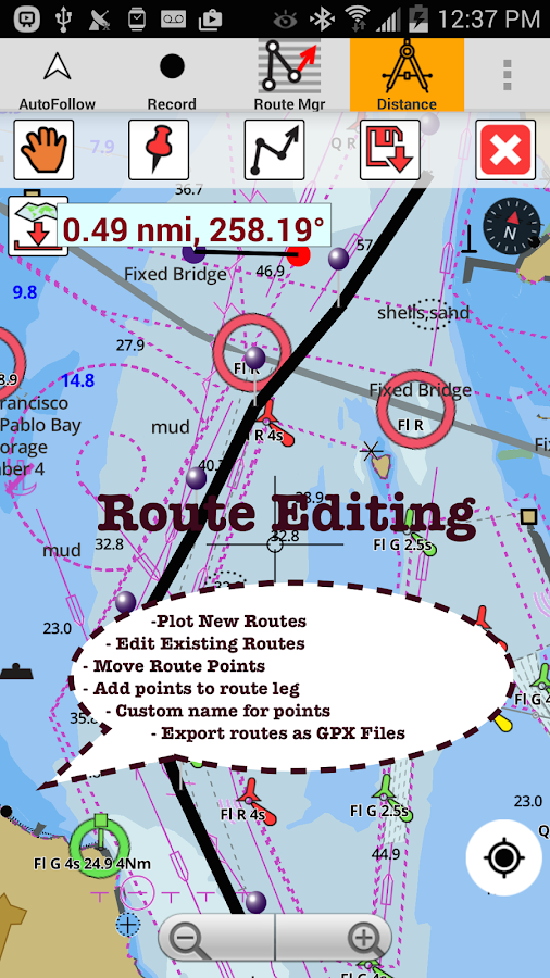
GPS Marine Charts App offers access to chartscovering Portugal waters (derived from IHP ( Instituto Hidrográficoof Portugal)data).Only marine GPS app to have route assistance with Voice Prompts formarine navigation. It has route manager to create new boatingroutes or import existing GPX/KML routes. It supports NauticalCharts course up orientation.Please visithttp://gpsnauticalcharts.com/main/portugal/all-all-portugal-charts-nautical-charts-folio.htmlfor complete list. If you don't find the chart for Portugal ,please contact us at support at gpsnauticalcharts.com.* Voice Prompts for marine navigation (requires GPS )-prompts when approaching a boating route marker-Continous distance and ETA updates-Alerts when sailing/boating off route-Alerts when boating in wrong direction*Route Editing/Creation-Create routes from scratch-Edit existing GPX/KML routes.-Add custom description to any route point.-Drop markers along route.* Offline charts derived from IHM data.-Visually draw area to download-Textual search-Catalog-Charts reprojected for WGS84 datum*Seamless chart quilting of marine charts*Distance Bearing tool*Create custom way points- Using GPS-Select point on map-Manually enter latitude & longitude coordinates*POI layer for marine charts- Overlay POIs- POI list derived from the equivalent ENC and contains allcategories including Buoy, Light, Harbour facility, Obstr.*Search POIs/Way points*Pan/Zoom/My Location* Record Marine GPS tracks* View tracks overlay* Live track animation* Track analytics/stats* Export GPX tracks.-Export to SDCard-Share GPX trakcs with friends/View on Google earth.* Auto Follow Mode (Course up)-Continuously updates boat's location on chart- Adjustable update frequencySample Nautical ChartsA Approaches to AveiroA AzinheiraA Figueria da FozAngra Do HeroismoA Porto de Leixoes and Barra do Rio DouroApproaches to Faro and OlhaoApproaches to Figueira da FozApproaches to Leixoes and Barra do Rio DouroApproaches to SinesArquipelago dos Acores Central GroupA SinesBaia de Mossamedes (Little Fish Bay)Baia de Santa MariaBaia de Santa MartaBaia de Sao LourencoBaia do DandeBaia dos ElefantesBaia dos TigresBaia FartaBissauB MontijoB Porto de AveiroCabo de Sao Sebastiao to BeiraCabo de Sao Vicente to FaroCabo Mondego to Cabo EspichelCanal Do FaialCanal do Geba and BissauC Baia do Porto SantoC Continuation to AveiroD Porto do Porto SantoEnseada do CapuloEnseada do CuioEntrance to Rio Tejo including Baia de CascaisFunchalGunza-Kabolo (Novo Redondo)HortaIlha de Santa Maria with Banco das FormigasIlha de Sao MiguelIlhas Flores and CorvoLajesLisboa Alcantara to Canal do MontijoLisboa Paco de Arcos to Terreiro do TrigoMachico and CanicalMontedor to Cabo MondegoPonta DelgadaPonta Gorda to Ponta de Sao LourencoPortimaoPorto AlexandrePorto AmboimPorto de BenguelaPorto de LuandaPorto do AmbrizPorto do LobitoPorto N'zetoPraia Da VitoriaSanta CruzSetubal and ApproachesSetubal Carraca to Ilha do CavaloViana Do CasteloViana do Castelo and ApproachesVila Da PraiaVila do Porto

i-Boating:Estonia Marine Chart 86.0 APK
GPS Marine Charts App offers access to charts covering Estonia(derived from EMA(Estonian Maritime Administration) data) with POIlayers created from ENC charts. Only marine GPS app to have routeassistance with Voice Prompts for marine navigation. It has routemanager to create new boating routes or import existing GPX/KMLroutes. It supports Nautical Charts course up orientation. * VoicePrompts for marine navigation (requires GPS ) -prompts whenapproaching a boating route marker -Continous distance and ETAupdates -Alerts when sailing/boating off route -Alerts when boatingin wrong direction *** For any question, contact support atgpsnauticalcharts.com / http://www.gpsnauticalcharts.com *** *RouteEditing/Creation -Create routes from scratch -Edit existing GPX/KMLroutes. -Add custom description to any route point. -Drop markersalong route. * Offline Estonia charts. Charts are created from EMAENC data. -Visually draw area to download -Textual search -Catalog-Charts in WGS84 datum *Seamless chart quilting of marine charts*Distance Bearing tool *Create custom way points - Using GPS-Select point on map -Manually enter latitude & longitudecoordinates *POI layer for marine charts - Overlay POIs - POI listderived from the equivalent ENC and contains all categoriesincluding Buoy, Light, Harbour facility, Obstr. *Search POIs/Waypoints *Pan/Zoom/My Location * Record Marine GPS tracks * Viewtracks overlay * Live track animation * Track analytics/stats *Export GPX tracks. -Export to SDCard -Share GPX trakcs withfriends/View on Google earth. * Auto Follow Mode (Course up)-Continuously updates boat's location on chart - Adjustable updatefrequency Sample Nautical Charts (please visithttp://gpsnauticalcharts.com/main/folio-catalog-nautical-charts-appfor complete list) Narva to Vergi North from Bay of Tallinn Northfrom Hiiumaa Parnu Bay, Estonian- Latvian Border Islands Muhu,Saaremaa, Ruhnu Nort-West Boarder of Estonia Swedis and Irbe Straitto Estonia Border North Estonia North-west Estonia Northern part ofIsland Hiiumaa Contiquous Zone with Finland East side of WestEstonian Archipelago Island Saaremaa-Island Hiiumaa Island RuhnuEstonian-Swedish Barder Estonian-Russian border, Narva Bay Thischart has been created in dKart Editor Irbe Strait to Estonianborder Mustvee to Vasknarva Kodavere to Raskopelski bay Praaga toKolpino Island Toila to Narva-Joesuu Purtse Port to ToilaApproaches to Ports of Tallinn and Muuga Suur Pakri-RohukylaOsmussaar-Vormsi-Heltema Island Hiiumaa West Coast of IslandHiiumaa East Side of West Estonian Archipelago Island Muhu-EastSide of Saaremaa Approaches to Ports of Soru and Triigi West coastof Island Saaremaa Peninsula Sorve, EE-LV Border W from SaaremaaIsland Abruka,Estonian-Latvian border Island Ruhnu Approach to Portof Parnu Approach to Port of Kunda Approach to Port of VergiPeninsula Kaberneeme to Port Loksa Approaches to Ports of Tallinnand Muuga Peninsula Pakri Sviby-Heltermaa-Rohukula Soela Strait toTriigi Bay From Soela to Triigi Parnu Bay Kihnu Strait Loksa andHara Muuga Kopli Kopli Pakri Haapsalu laht Rukkirahu kanal-Rohukulasadam Harbour Soru Vainameri (West-Estonian Archipelago)Roomassaare Saaremaa Eesti Varav Channel Varska Bay Montu LeppneemeRohuneeme Miiduranna and Pirita Harbours Vanasadam PaljassaareNaissaar Haapsalu laht Rohukyla Lehtma Lounaranna HeltermaaOrissaare Triigi Soru Saaremaa Veere Koguva Karsa Virtsu Harbourand Virtsu Vanasadama Kungla Kuivastu Parnu Roomassaare KuressaareAbruka Nasva Salme Joesadam Lomala Kaunispe Munalaid and ManilaidKihnu Ringsu Piirissaar Harbour and Channel Laakssaare SillamaeKunda River Emajogi 2, Kastre Village to Vana-Kastre VillageEmajogi 3,Vana-Kastre Village to Tartu Tartu to Kardla VillageKardla Village to Ramsi Village Ramsi Village to Lake VortsjarvLake Peipus to Kastre Village Narva river (1,2,3,4,5), fromNarva-Joesuu to Narva

Europe Inland Rivers-Waterways 102.0 APK
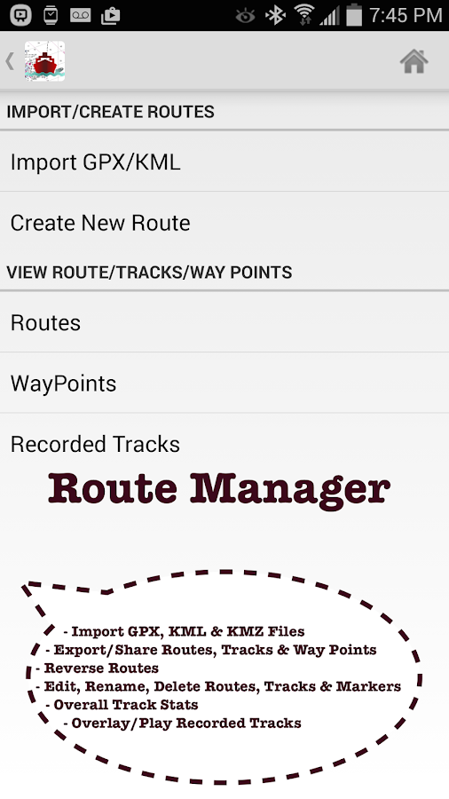
Europe Inland Rivers/Waterways Navigation /Charts App offers access to nautical charts covering major rivers,canals and waterways in Europe - Danube/Donau/Dunaja, Sava, Drava,Rhein, Ruhr, Saar, Sulina, Mosel/Moselle, Elbe, Dijle, Zeekanaletc. All charts include POI data. It supports Marine Charts courseup orientation. It has route manager to create new boating routesor import existing GPX/KML routes.Only marine navigation app to have route assistance with VoicePrompts for marine navigation.* Voice Prompts for marine navigation / nautical naviagtion(requires GPS )-prompts when approaching a boating route marker-Continous distance and ETA updates-Alerts when sailing/boating off route-Alerts when boating in wrong direction*** For any question, contact support at gpsnauticalcharts.com /http://www.gpsnauticalcharts.com ****Route Editing/Creation-Create routes from scratch-Edit existing GPX/KML routes.-Add custom description to any route point.-Drop markers along route.► Advanced NMEA Instrumentation√AIS over TCP/UDP√Wind speed, direction, temperature, depth, GPS over NMEA* Offline charts-Charts reprojected for WGS84 datum.*Seamless chart quilting of marine charts*Distance Bearing tool*Create custom way points- Using GPS-Select point on map-Manually enter latitude & longitude coordinates*POI layer for marine charts- Overlay POIs- POI list derived from the equivalent ENC and contains allcategories including Buoy, Light, Harbour facility, Obstr.*Search POIs/Way points*Pan/Zoom/My Location* Record Marine GPS tracks* View tracks overlay* Live track animation* Track analytics/stats* Export GPX trcks.-Export to SDCard-Share GPX trakcs with friends/View on Google earth.* Auto Follow Mode (Course up)-Continuously updates boat's location on chart- Adjustable update frequencySample Nautical Charts (please visithttp://gpsnauticalcharts.com/main/folio-catalog-nautical-charts-appfor complete list)*Austria - Donau*Belgium - Rupel, Netekanaal, Ringvaart om Gent,Schelde-Rijnverbinding, Dijle, Kanaal naar Charleroi, BenedenZeeschelde, Bocholt-Herentals, Gent-Terneuzen, van ZeebruggeAchterhaven-inclusief het Boudewijnkanaal-tot en met haven Brugge,Zuid-Willemsvaart, Antwerpen Haven, Moervaart, Beneden-Nete,Dessel-Kwaadmechelen, Estuaire Vaart van Zeebrugge tot aan deNederlandse Grens, Leie, Oostende Plassendalekanaal, Boven-Schelde,Vlaanderen, Zeekanaal, Albertkanaal, Oostende Haven met de5-mijlszone Estuaire Vaart, Zeeschelde,*Bulgaria*Switzerland - Rhine*Czech Republic - Roudnice nad Labem, Kly, Lovosice, Libotenice,Kostelec nad Labem, Melnik, Hraz Slapske prehrady, Praha -Holesovice, Steti, Libcice nad Vltavou, Praha - Modrany, Podebrady,Usti nad Labem, Veltruby, Melnik - soutok, Vrane nad Vltavou,Chvaletice, Vranany, Hradistko, Dolni Zleb, Neratovice, Celakovice,Statni hranice CR - SRN, Nymburk, Brna nad Labem, Brandys nadLabem, Kralupy nad Vltavou, Litomerice, Hradistko, Male Brezno,Roztoky, Kolin, Decin,*Germany - Elbe, Westoder, Ruhr, Rhein-Herne-Kanal, UntereHavel-Wasserstraße (Spandau - Plaue), Weser, Neckar,Berlin-Spandauer-Schifffahrtskanal, Donau, Rhein,Spree-Oder-Wasserstraße, Havel-Oder-Wasserstraße, Main-Donau-Kanal,Wesel-Datteln-Kanal, Elbe-Havel-Kanal, Dortmund-Ems-Kanal,Elbe-Seitenkanal, Mittellandkanal, Mosel, Main, Saar*France - GRANDE SAONE, MOSELLE CANALISEE, LIAISON DUNKERQUEESCAUT, GARONNE*Croatia - DRAVA, DANUBE, SAVA*Hungary - Danube*Netherlands*Romania - Maritime Danube, Sulina Channel, Danube Black SeaChannel*Serbia - Danube, Sava, Tisa*Slovakia - Dunaja / Danube

Marine/Nautical Charts-Germany 102.0 APK
GPS Marine Charts App offers access to chartscovering Germany (derived from BSH(Bundesamt für Seeschifffahrt undHydrographie) data) with POI layers created from ENC charts. Onlymarine GPS app to have route assistance with Voice Prompts formarine navigation. It has route manager to create new boatingroutes or import existing GPX/KML routes. It supports NauticalCharts course up orientation.* Voice Prompts for marine navigation (requires GPS )-prompts when approaching a boating route marker-Continous distance and ETA updates-Alerts when sailing/boating off route-Alerts when boating in wrong direction*** For any question, contact support at gpsnauticalcharts.com /http://www.gpsnauticalcharts.com ****Route Editing/Creation-Create routes from scratch-Edit existing GPX/KML routes.-Add custom description to any route point.-Drop markers along route.* Offline German charts. Charts are created from BSH ENCdata.-Visually draw area to download-Textual search-Catalog (North Sea, Baltic Sea)-Charts reprojected for WGS84 datum► Advanced NMEA Instrumentation√AIS over TCP/UDP√Wind speed, direction, temperature, depth, GPS over NMEA*Seamless chart quilting of marine charts*Distance Bearing tool*Create custom way points- Using GPS-Select point on map-Manually enter latitude & longitude coordinates*Pan/Zoom/My Location* Record Marine GPS tracks* View tracks overlay* Live track animation* Track analytics/stats* Export GPX tracks.-Export to SDCard-Share GPX trakcs with friends/View on Google earth.* Auto Follow Mode (Course up)-Continuously updates boat's location on chart- Adjustable update frequencySample Nautical Charts (please visithttp://gpsnauticalcharts.com/main/folio-catalog-nautical-charts-appfor complete list)LauterbachGagerPeenemuendeVierowRudenKröslinWolgastPeenestrom / Negenmark RinnePeenestrom / Der StromUeckerBerndshofListHoernumAmrumDagebuellWykSchluettsielHelgolandBuesumMeldorfEiderPellwormStrucklahnungshoernHusumDove HarleRendsburgCuxhavenBrunsbuettelGlueckstadtHamburgStadersandBremerhavenOldenburgElsfleth and Hunte MouthBrakeBremenWilhelmshavenFischerbalje and BorkumNorddeichNorderneyLangeoogBensersielEmdenEms Southern PartWendtorfKamp to KarninEidersperrwerkToenningFriedrichstadtBaltic SeaGerman BightWaters north of KielMecklenburger BuchtWaters west of RuegenWaters east of RuegenWaters north of HelgolandWaters south of HelgolandFlensburger FoerdeGeltinger BuchtEckernfoerder BuchtSchleiFehmarn BeltLuebecker BuchtNeustaedter BuchtWismar ApproachRostock ApproachSaaler BoddenStralsund ApproachesNorthern coastal waters of RuegenSassnitz ApproachGreifswalder BoddenGreifswald ApproachUsedomNorth Frisian Islands northern partNorth Frisian Islands southern part, Eider ApproachHelgoland ApproachJade and Weser ApproachElbe northern partKiel CanalKiel Canal ApproachElbe southern partWeser northern partWeser southern part and HunteJadeJuist to SpiekeroogEms ApproachEms Northern PartDollartFlensburgFahrensoddeGluecksburgSchausendeLangballigauGeltingSchleswigStexwigFleckebyMissundeLindaunisArnisKappelnMaasholmSchleimuende and OlpenitzDampEckernfoerdeKielMarina LippeHeiligenhafenBurgstaakenGrossenbrodeMarina GroemitzNeustadtNiendorfLuebeck HarboursWismarTimmendorfKirchdorfBoltenhagenRostockKuehlungsbornStralsund

i-Boating:Europe Inland Rivers 102.0 APK
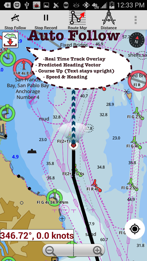
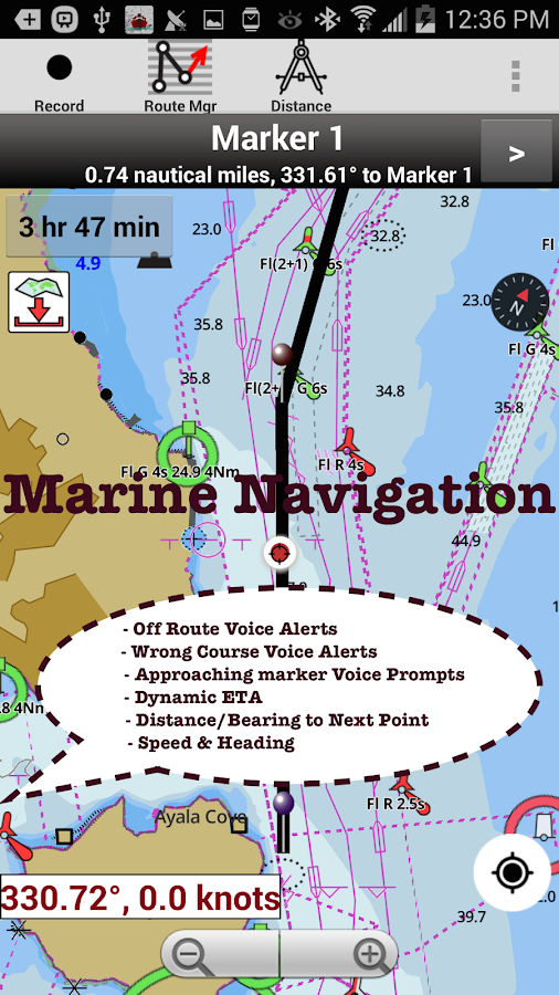
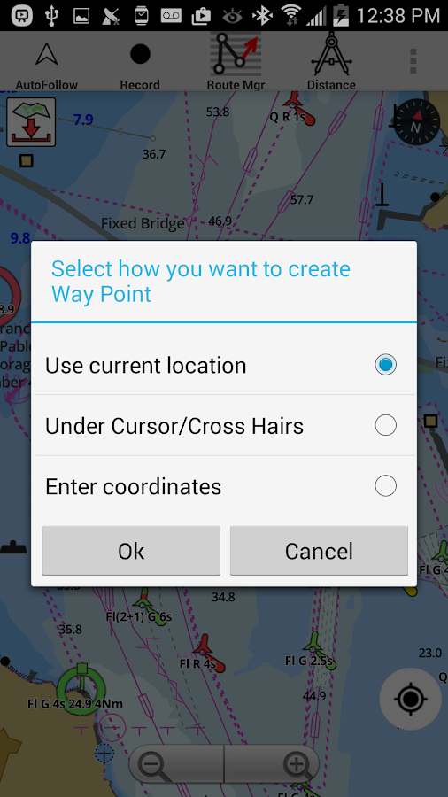
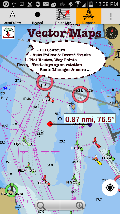
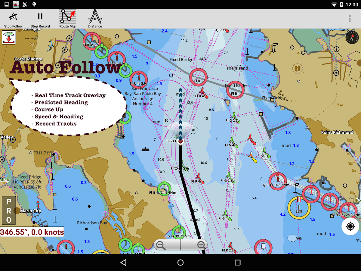
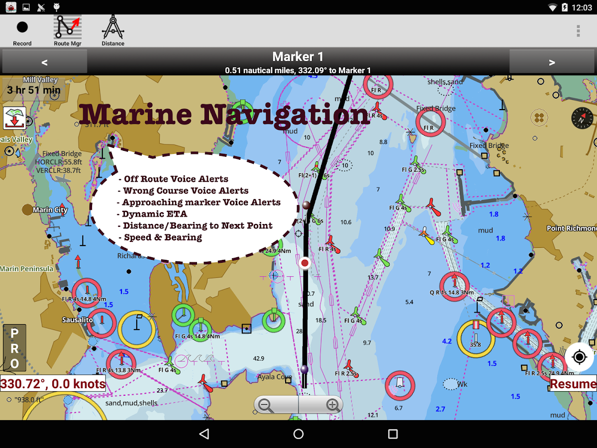
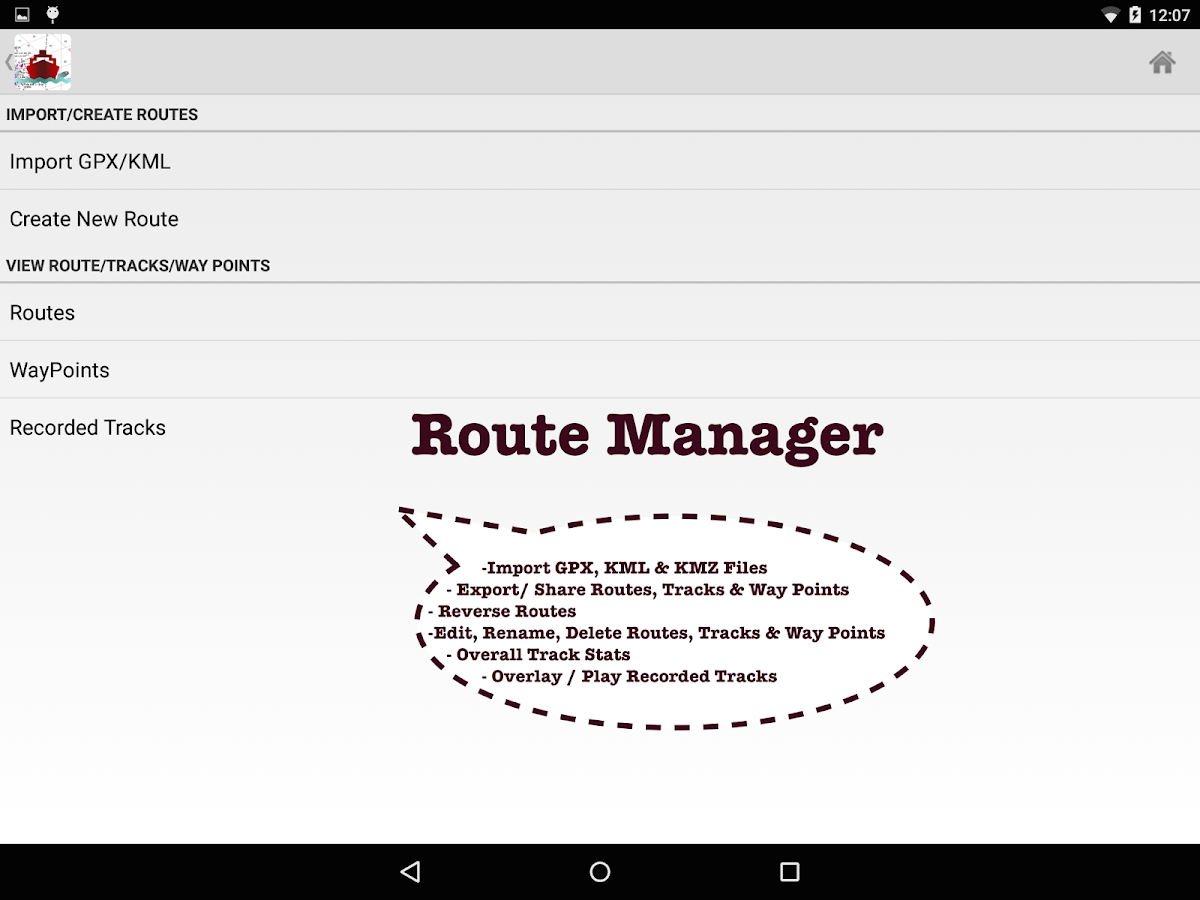
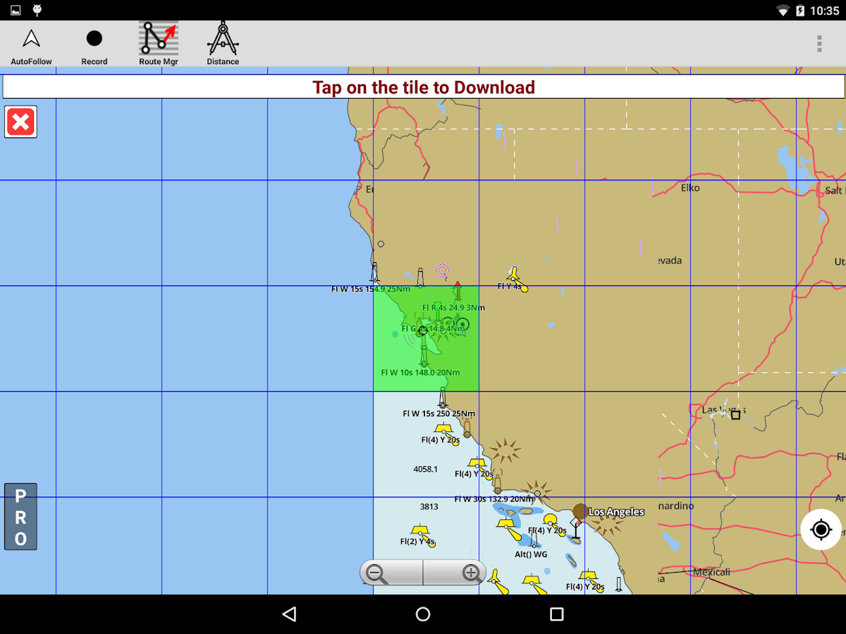
This App offers offline nautical charts, lake& river navigation maps for fishing, kayaking, boating andsailing. Coverage includes marine vector charts, freshwater lakemaps, and inland river maps (HD/1ft/3ft bathymetry included whereavailable). First marine GPS app to have route assistance withVoice Prompts for marine navigation. You can create new boatingroutes or import existing GPX/KML routes. It supports NauticalCharts course up orientation. Incl Tide & Currents prediction.►FEATURES√ Beautiful and detailed Hardware/GPU accelerated vector charts(text stays upright on rotation)√ Query details of Marine object (Buoy, Lights, Obstructionetc).√ Customizable depth(Ft/Fathom/Meter) and distance units(km/mi/NM)√ Customizable Shallow Depth.√ Record tracks, Autofollow with real-time track overlay &predicted path vector.√ Voice Prompts for marine navigation (requires GPS )√ 1ft / 3ft depth contour maps for anglers for selected lakemaps.√ Supports GPX/KML for boating route editing/import.√ Tide & Currents prediction.√ Seamless chart quilting. Map details from Coastal,Approaches,Harbour, Inland Encs(rivers), and general ENC charts areautomatically mapped to correct zoomlevel√ Enter or import Waypoints.► MAPSGet all the details that you find in your chart plotters!Includes unlimited updates for 1 year.Europe Inland Rivers & Waterways:Donau/Danube/Dunaja,Rhine,Rhein,Garonne,Moselle,Drava,Sava,etc.►Advanced NMEA Instrumentation√ AIS over TCP/UDP√ Wind speed, direction, temperature, depth, GPS over NMEA►ROUTE MANAGEMENT / TRIP PLANNING√ Create New Route/Edit Routes√ Reverse Routes√ Enter,Move, Add, Delete, Rename Waypoints√ Import GPX, KML & KMZ files√ Plot/Edit Routes√ Share/Export Routes, Tracks & Markers►GPS FEATURES√ Auto Follow* Real Time Track Overlay* Predicted Path Vector* Course Up (Text stays upright)* Speed & Heading√ Route Assistance With Voice Prompts* Prompts when approaching a boating route marker* Continous distance & ETA updates* Alerts when sailing/boating off route* Alerts when boating in wrong direction√ Record Tracks►TIDE & CURRENTS* For US, Canada, UK,Germany&New Zealand* High/Low Tides* Tidal Current Prediction* Active Current Stations► SHARING* Share tracks/routes/markers on Facebook & Twitter* Export tracks/routes/markers as compressed GPX files.*Austria-Donau*Belgium-Rupel,Netekanaal,Ringvaart omGent,Schelde-Rijnverbinding,Dijle,Kanaal naar Charleroi,BenedenZeeschelde,Bocholt-Herentals,Gent-Terneuzen,van ZeebruggeAchterhaven-inclusief het Boudewijnkanaal-tot en met havenBrugge,Zuid-Willemsvaart,AntwerpenHaven,Moervaart,Beneden-Nete,Dessel-Kwaadmechelen,Estuaire Vaartvan Zeebrugge tot aan de Nederlandse Grens,Leie,OostendePlassendalekanaal, Boven-Schelde, Vlaanderen, Zeekanaal,Albertkanaal, Oostende Haven met de 5-mijlszone Estuaire Vaart,Zeeschelde,*Bulgaria*Switzerland - Rhine*Czech Republic - Roudnice nad Labem, Kly, Lovosice, Libotenice,Kostelec nad Labem, Melnik, Hraz Slapske prehrady, Praha -Holesovice, Steti, Libcice nad Vltavou, Praha - Modrany, Podebrady,Usti nad Labem, Veltruby, Melnik - soutok, Vrane nad Vltavou,Chvaletice, Vranany, Hradistko, Dolni Zleb, Neratovice, Celakovice,Statni hranice CR - SRN, Nymburk, Brna nad Labem, Brandys nadLabem, Kralupy nad Vltavou, Litomerice, Hradistko, Male Brezno,Roztoky, Kolin, Decin,*Germany - Elbe, Westoder, Ruhr, Rhein-Herne-Kanal, UntereHavel-Wasserstraße (Spandau - Plaue), Weser, Neckar,Berlin-Spandauer-Schifffahrtskanal, Donau, Rhein,Spree-Oder-Wasserstraße, Havel-Oder-Wasserstraße, Main-Donau-Kanal,Wesel-Datteln-Kanal, Elbe-Havel-Kanal, Dortmund-Ems-Kanal,Elbe-Seitenkanal, Mittellandkanal, Mosel, Main, Saar*France - GRANDE SAONE, MOSELLE CANALISEE, LIAISON DUNKERQUEESCAUT, GARONNE*Croatia - DRAVA, DANUBE, SAVA*Hungary - Danube*Netherlands*Romania - Maritime Danube, Sulina Channel, Danube Black SeaChannel*Serbia - Danube, Sava, Tisa*Slovakia - Dunaja / Danube

i-Boating:Brazil Marine Charts 86.0 APK
GPS Marine Charts App offers access to chartscovering Brazil waters (derived from IHP CENTRO DE HIDROGRAFIA DAMARINHAdata).Only marine GPS app to have route assistance with Voice Prompts formarine navigation. It has route manager to create new boatingroutes or import existing GPX/KML routes. It supports NauticalCharts course up orientation.Please visithttp://gpsnauticalcharts.com/main/brazil/all-all-brazil-charts-nautical-charts-folio.htmlfor complete list. If you don't find the chart for Brazil , pleasecontact us at support at gpsnauticalcharts.com.* Voice Prompts for marine navigation (requires GPS )-prompts when approaching a boating route marker-Continous distance and ETA updates-Alerts when sailing/boating off route-Alerts when boating in wrong direction*Route Editing/Creation-Create routes from scratch-Edit existing GPX/KML routes.-Add custom description to any route point.-Drop markers along route.* Offline charts derived from IHM data.-Visually draw area to download-Textual search-Catalog-Charts reprojected for WGS84 datum*Seamless chart quilting of marine charts*Distance Bearing tool*Create custom way points- Using GPS-Select point on map-Manually enter latitude & longitude coordinates*Pan/Zoom/My Location* Record Marine GPS tracks* View tracks overlay* Live track animation* Track analytics/stats* Export GPX tracks.-Export to SDCard-Share GPX trakcs with friends/View on Google earth.* Auto Follow Mode (Course up)-Continuously updates boat's location on chart- Adjustable update frequency►Instrumentation√ Marine AIS & (NMEA AIS and GPS over TCP/UDP)√ Wind direction & Speed,Sonar depth,Water temperatureSample Nautical ChartsARQUIPELAGO DE SAO PEDRO E SAO PAULOATOL DAS ROCASBAIA DA ILHA GRANDE PARTE CENTRALBAIA DE GUANABARATODOS OS SANTOS PARTE NORTEBAIAS CABRALIA E DE PORTO SEGUROBARRA DO RIO DE JANEIROBARRA DO RIO GUAIBACANAL DE SANTANACANAL DE SAO ROQUECANAL DOS ABROLHOSCANAL NORTE DE SANTA CATARINACANAL SUL DE SANTA CATARINACOSTA SUESTE DA AMERICA DO SULCURRALINHOSUCURI AO PASSO OLIMPOCASTELO AO JATOBAZINHODO CURURU A ILHA DO CASTELODO PAPAGAIO AO PASSO DO MORRO PELADODO TUIUIU A CANCHA DO PIUVALDA CONCEICAO DA BARRA A VITORIADA FOZ DO RIO NEGRO A ILHA PATATIVADAS COUVES A ILHA DO MAR VIRADODO BAILIQUE A PONTA DO CAPINALRABO DE EMA À ILHA DO ALGODOALDA ILHA SEPUTA A FOZ DO RIO NEGROVERDE AO PASSO PARAGUAI MIRIMDEL LOCO AO PASO SIETE PUNTASESPERANZA A ISLA YSYPO-IPEDERNAL AO PASO CAA-PUCU-MIPITO-CAÑY A ISLA OCULTOPOYBIA A ISLA URUGUAYTASAN ALFREDO A ISLA SAN JUANDO UBU AO CABO DE SAO TOMEGROSSA A PORTO ALEGREMACEIO AO CABO CALCANHARDA PONTA TUCUMA A PONTA DO GUARADA SARACURA AO ESTIRÃO DOMINGOS RAMOSDA SUCURI AO PASSO COQUEIRODO ACURIZAL AO RIACHO DO ABRIGODO CARANDAZINHO A VOLTA DO CURURUDO JAU AO ESTIRÃO DA CAPIVARADO SINIMBU AO PASSO PIUVAGRANDE A ILHA ESTREITA OU PIMENTEIRAMORCEGUEIRO AO PASSO DA FAIADE BELA VISTA DO NORTE AO ESTIRDE CAYENNE AO CABO GURUPIDE CORUMBA AO ESTIRAO DA AGUA BRANCADE IMBITUBA A PINHALDE ITAPUA A PONTA DO ARADO VELHODE SANTOS A ARROIO CHUIDE VITORIA AO CABO DE SAO TOMESIETE PUNTAS AO PASO MILAGROREBOJO GRANDE A ILHA DO MARCODO RECIFE A BELMONTEENSEADA DE BUZIOSENSEADA DE MACAEENSEADA DE UBATUBAENSEADAS DO CABO FRIOFOZ DO RIO APAFUNDEADOURO DE SAO MIGUELILHA GAMELA E FOZ DO RIO BRACINHOLAGOA GALAGO DE BRASILIABRASILIA - PARTE CENTRALCABEDELOCAMAMUCANANÉIACARAVELASIMBITUBALAGUNALUIS CORREIAMACAUMACEIOMADRE DE DEUSNATALSANTANASANTOSSANTOS - CANAL DE ACESSOPORTO DE SAO ROQUEPORTO DO RIO DE JANEIROPORTO LUIS CORREIABARRA SUL DO RIO AMAZONASILHA DE SANTA CATARINAPONTA DO UBUATOL DAS ROCASPORTO DE MACEIOPUERTO VALLEMIRIO PARAGUAI

i-Boating: Argentina Marine Ma 86.0 APK
GPS Marine Charts App offers access to charts covering Argentinawaters (derived from SHN(Servicio de Hidrografía Naval ofArgentina) data). Only marine GPS app to have route assistance withVoice Prompts for marine navigation. It has route manager to createnew boating routes or import existing GPX/KML routes. It supportsNautical Charts course up orientation. Please visithttp://www.gpsnauticalcharts.com/main/argentina/all-all-argentina-charts-nautical-charts-folio.htmlfor complete list. If you don't find the chart for Argentina ,please contact us at support at gpsnauticalcharts.com. * VoicePrompts for marine navigation (requires GPS ) -prompts whenapproaching a boating route marker -Continous distance and ETAupdates -Alerts when sailing/boating off route -Alerts when boatingin wrong direction *Route Editing/Creation -Create routes fromscratch -Edit existing GPX/KML routes. -Add custom description toany route point. -Drop markers along route. * Offline chartsderived from UKHO data. -Visually draw area to download -Textualsearch -Catalog (By state, region and coast guard district) -Chartsreprojected for WGS84 datum *Seamless chart quilting of marinecharts *Distance Bearing tool *Create custom way points - Using GPS-Select point on map -Manually enter latitude & longitudecoordinates *Pan/Zoom/My Location * Record Marine GPS tracks * Viewtracks overlay * Live track animation * Track analytics/stats *Export GPX tracks. -Export to SDCard -Share GPX trakcs withfriends/View on Google earth. * Auto Follow Mode (Course up)-Continuously updates boat's location on chart - Adjustable updatefrequency ►Instrumentation √ Marine AIS & (NMEA AIS and GPSover TCP/UDP) √ Wind direction & Speed,Sonar depth,Watertemperature Sample Nautical Charts (please visithttp://www.gpsnauticalcharts.com/ for complete list) A Continuationto Nueva Palmira Admiralty Bay and King George Bay Approaches toBahia Blanca Approaches to Danco Island Approaches to ProspectPoint Approaches to Rio de La Plata Approaches to the FalklandIslands A Puerto Mar del Plata A Puertos Ingeniero White- Nacionaland Galvan Ardley Cove Arthur Harbour Bahia Blanca Bahias Gil andHuevo B Approaches to Mar del Plata Bellingshausen Sea to ValdiviaBellingshausen Sea to Valdivia(Sheet B Nueva Palmira B PuertosBelgrano and Rosales Brabant Island to Adelaide Island CaboGuardian to Punta Nava Cabo Virgenes to Primera Angostura CaletasCordova and Olivares Caleta Sur Cal. Olivia Canal Leones and BahiaSan Gregorio Church Point to Cape Longing including James RossIsland Comodoro Rivadavia C Puerto San Blas Debenham IslandsDeception Island Desolation Island Detaille Island D Puerto SanAntonio Drake Passage Elephant Island and Approaches EllefsenHarbour English Strait (Northern Entrance) Entrance to Bahia BlancaE Puerto Quequen Estrecho de Magallanes Falkland Islands to CaboCorrientes and Northeast Georgia Rise Falkland Islands to CaboCorrientes and Northeast Georgia Rise(Sheet Falkland Islands toSouth Sandwich Islands and Graham Land Falkland Islands to SouthSandwich Islands and Graham Land(Sheet Gerlache Strait NorthernPart Gerlache Strait Southern Part Harmony Cove
Similar Apps Show More...


Marinus - Boating rules 4.2.7 APK
Marinus ColRegs is not one more app of thenavigation rules… is the APP of the navigation rules!Designed by and for the maritime and nautical people, that resolveyour doubts in any moment and anywhere. Is the app indispensableonboard of your sail or power boat!Include the next sections:• Flags: with every letter and significant.• Meteo: Beaufort and Douglas scale, and clouds.• Sonuds• Lights: with a detail view of every vessel in every angle.• Day shapes• Maneuvers• Morse• Buoys IALA• Radio• ColRegs: all the International Regulation for PreventingCollsions at Sea (IRPCS, Rules of the road, Collision rules) intext.• Quiz• MapDownload the app that miles of people use very day in theiriPhone. No matter if you are an experienced sailor or a novice,this is your app!Any question feel you free to ask to [email protected]


Free Nautical Charts 1.0.9 APK
Marine Ways Boating is the ultimate marinenavigation and planning application! In this application you willgain access to:FREE NAVIGATIONAL CHARTS- NOAA ENC Electronic Navigational Charts (NOAA's newest and mostpowerful electronic charting product)- NOAA BSB Classic Raster Charts (including Day, Red, Dusk, Night,and Gray versions)- All chart data is supplied by NOAA.Just toggle the chart you want in the map settings section and itwill show up on the map! Zoom in for the finest detail!ROUTE PLANNING TOOLS-Route Plotting. Tap and hold on the map for one second to plotyour waypoints. To form a route, continue to tap and hold on themap in different areas. Distance and bearing are convenientlycalculated and displayed for each leg as you add, adjust, or removewaypoints.-Travel Mode. Automatically centers the map on your currentposition as you move. Use travel mode to see how closely you arefollowing your plotted route in real time!-Route Leg Summary. A convenient view containing detailedinformation of each leg you have plotted, including start and endcoordinates, distance, and bearing.BUOY REPORTS AND OBSTRUCTION INFORMATIONMarkers for buoys and obstructions are conveniently plotted intheir actual location on the map! Just click on the marker to viewtheir information!- Buoy Reports: Get complete current conditions and wave reportsfor fixed and drifting buoys.- Obstructions: Get location and history information aboutpotentially dangerous, submerged hazards including rocks and sunkenvessels.NAVIGATION DASHBOARDThe navigational dashboard shows various real-time informationincluding:- Current location (latitude and longitude, with accuracyrange)- Current Heading (includes a small directional compass aswell!)- Current Speed Over Ground- Current BearingMARINE MAP OVERLAYSToggle various marine overlay data right onto the map to get abetter idea of the current boating conditions!Overlays include:- Water Surface Temperature (Global)- Wind Speeds (US only)- Wind Gusts (US only)- Wave Heights (US only)LOCATION SHARING OVER WATER / VIEW OTHER BOATS- Display your last known location, speed, bearing, and boat nameon the map for other Marine Ways boaters to view.- View the last known location, speed, bearing, and boat name ofother Marine Ways boaters, as well as their distance and bearingfrom your location.- Location sharing is turned off by default. When you are ready toshare, toggle it on within general settings. To continuously updateyour location on the map, keep the app opened and focused. The appcurrently does not update your location in the background.WEATHER INFORMATION- Weather Precipitation Radar (US & Hawaii only). Detects anyrain and snow in the area.- Weather Station. Reports the nearest observation station data.Current temperature, humidity, weather conditions, wind, and more!Station observation data is available globally.- Weather Alerts. Weather station also reports any active weatheralerts issued by the National Weather Service such as severethunderstorm warnings or hurricane warnings. Weather alertinformation is available for US, Alaska and Hawaii.- Land Surface Temperature overlay. Shows the current surfacetemperature on land (US only).Before using this application, please read and agree to thefollowing terms of use / service and privacy policy:Terms of Use / Service: http://www.marineways.com/apptermsPrivacy policy: http://www.marineways.com/appprivacyNavigational Charts Disclaimer from NOAA:NOAA ENC Online is not certified for navigation. Screen captures ofthe ENCs displayed here do NOT fulfill chart carriage requirementsfor regulated commercial vessels under Titles 33 and 46 of the Codeof Federal Regulations.Enjoy the app! Marine Ways is also available on the web athttp://www.marineways.com

cats.maps_navigation Top Show More...

ta3lim siya9a maroc belvideo 1.4.2 APK
امتحان رخصة السياقة بالمغرب 2015 هوتطبيقمغربيوبالدارجة المغربية خاص بمساعدة كل المقدمين علىاجتيازامتحانرخصةالسياقة بالمغرب كلهذا باللهجة التب يعرفها الجميع في المغرب وهي الدارجةالمتداولةأهم مايميز تطبيق امتحان رخصة السياقة بالمغرب انهنفسأسئلةالامتحاناتالموجودة في مدارس تعليم السياقة بالمغربكل الأسئلة المحتملة للامتحانات الموجودة في مدارس تعليمالسياقةأسؤلة صوتية أي مسموعة ومقروءة في نفس الوقتوغيرها من الميزات الكثير الكثيروشكرااta3lim siya9a belmagherib application jadidafihal3adidminalvideouhatta3lim wa ta3lam kayfa tata3lam salasil rokhesa siya9asiya9a ta3lim maroc fih jadid kol mayakhos rokhesat siya9afih majmo3a mina doross 3la chakli video salihalikolisanasawa2an2015 wella 2016 ila ghayeri thalik minal2a3wamامتحانرخصةالسياقةبالمغرب2015 هو تطبيق مغربي و بالدارجة المغربية خاصبمساعدةكلالمقدمين علىاجتياز امتحان رخصة السياقة بالمغرب كلهذا باللهجة التب يعرفها الجميع في المغرب وهي الدارجةالمتداولةأهم مايميز تطبيق امتحان رخصة السياقة بالمغرب انهنفسأسئلةالامتحاناتالموجودة في مدارس تعليم السياقة بالمغربكل الأسئلة المحتملة للامتحانات الموجودة في مدارس تعليمالسياقةأسؤلة صوتية أي مسموعة ومقروءة في نفس الوقتوغيرها من الميزات الكثير الكثيروشكرااta3lim siya9a belmagherib implementation Jadidafihal3adidminalvideouhatta3lim wa ta3lam kayfa tata3lam Salasil rokhesa siya9asiya9a ta3lim Morocco fih jadid kol mayakhos rokhesat siya9afih majmo3a mina doross 3la chakli video salihalikolisanasawa2an2015 wella 2016 ila ghayeri thalik minal2a3wam

Map of China 1.24 APK
This is an application that turnsyourAndroiddevice into a GPS navigator with offline maps. Youcansearcheasily locations in China and you can add them toyourroute.Discover interesting places near you:accommodation,parking,restaurants, bars, clubs, cinemas, theatres,auto services,shops,parks, schools, hospitals, sport areas.It includes detailed maps of the biggest cities inChina:Shanghai,Beijing, Chongqing, Shenzhen, Guangzhou, Tianjin,Wuhan,Dongguan,Foshan, Chengdu, Nanjing, Shenyang, Xi'an,Hangzhou,Harbin,Suzhou, Qingdao, Dalian, Zhengzhou, Shantou,Jinan,Changchun,Kunming, Hong Kong, Changsha, Taiyuan, Xiamen,Hefei,Ürümqi,Fuzhou and others.This application is based on Osmand project under theGNUGPLv3license and uses high quality data from OSM.

Map of Hungary 1.24 APK
This app turns your Android device intoaGPSnavigator with offline maps.You can search easily locations in Hungary and you can addthemtoyour route.Discover interesting places near you:accommodation,parking,restaurants, bars, clubs, cinemas, theatres,auto services,shops,parks, schools, hospitals, sport areas.It includes detailed maps of the biggest cities inHungary:Budapest,Debrecen, Szeged, Miskolc, Pecs, Gyor,Nyiregyhaza,Kecskemet,Szekesfehervar and others.This application is based on Osmand project under theGNUGPLv3license and uses high quality data from OSM.


Map of Germany 1.25 APK
Install this app on your device andyou'llgetan GPS navigator with offlline maps.You'll get access to the interesting points that can be foundonyourway: accommodation, parking, restaurants, bars,clubs,cinemas,theaters, auto services, shops, parks, schools,hospitals,sportareas.Audio and visual guidance will help you reachyourdestination.The application has detailed maps of major cities inGermany:Berlin,Hamburg, Munich, Koln, Frankfurt am Main,Stuttgart,Dortmund, Essen,Dusseldorf, Bremen, Hannover, Leipzig,Duisburg,Nurnberg, Dresden ,Bochum, Wuppertal, Bielefeld, Bonn,Mannheimand others.This application is based on Osmand project under theGNUGPLv3license and uses high quality data from OSM.

АВТОтема. Всё для Вашего авто. 1.0.7 APK
Загружайте и пользуйтесь самой полнойбазойместдля ремонта и техобслуживания автомобиля. Приложениедоступноболеечем в 300 городах России, Украины, Киргизии иКазахстана.Установите приложение, и оно покажет на картеближайшиеСТО,автомойки, автозаправки и магазины автозапчастей врадиусе2хкилометров от Вас.В приложении есть адреса и телефоны автосервисов,времяработы,ссылки на сайты и отзывы клиентов. Звоните вавтосервисыпрямо изприложения, и здесь же смотрите схему проезда –приложениепокажетудобный маршрут до нужного местатехобслуживания.АВТОтема поможет найти компанию для тюнинга автомобиляилисервис,которому можно доверить ремонт двигателя, кузоваилиходовойчасти!• Если нужен поиск в другой части города, используйте«долгийтап»(прикоснитесь и удерживайте) в нужной точке накарте• Пользуйтесь тематическим разделами (автосервис,автомойка,АЗС,шиномонтаж, автозапчасти, тюнинг, автостоянка)• Чтобы увидеть автосервисы в других городах, выберете нужныйгородвменюАВТОтема – бесплатное приложение без рекламы!Краткий список городов: Москва,Санкт-Петербург,Новосибирск,Абакан (Минусинск), Алматы,Альметьевск, Армавир,Архангельск,Астана, Астрахань, Барнаул,Белгород, Бийск, Бишкек,Благовещенск,Братск, Брянск, ВеликийНовгород, Владивосток,Владимир, Волгоград,Вологда, Воронеж,Горно-Алтайск,Днепропетровск, Донецк,Екатеринбург, Иваново, Ижевск,Иркутск,Йошкар-Ола, Казань,Калининград, Калуга,Каменск-Уральский,Караганда, Кемерово, Киев,Киров,Комсомольск-на-Амуре, Кострома,Краснодар, Красноярск,Курган, Курск,Ленинск-Кузнецкий, Липецк,Магнитогорск, Махачкала,Миасс, Мурманск,Набережные Челны, Находка,Нижневартовск, НижнийНовгород, НижнийТагил, Новокузнецк,Новороссийск, Норильск,Ноябрьск, Одесса, Омск,Орёл, Оренбург,Павлодар, Пенза, Пермь,Петрозаводск,Петропавловск-Камчатский,Псков, Пятигорск (КМВ),Ростов-на-Дону,Рязань, Самара, Саранск,Саратов, Смоленск, Сочи,Ставрополь, СтарыйОскол, Стерлитамак,Сургут, Сыктывкар, Тамбов,Тверь, Тобольск,Тольятти, Томск, Тула,Тюмень, Улан-Удэ,Ульяновск, Уссурийск,Усть-Каменогорск, Уфа,Хабаровск, Харьков,Чебоксары, Челябинск,Чита, Южно-Сахалинск,Якутск, Ярославль.Download and usethemostcomprehensive database of places for vehiclerepairandmaintenance. The application is available in more than300citiesin Russia, Ukraine, Kyrgyzstan and Kazakhstan.Install the app and it will show on the map thenearestservicestations, car washes, gas stations and auto partsshops arewithina radius of 2 kilometers from you.The application has addresses and telephone numbersofservicestations, working hours, links to websites, andcustomerreviews.Call garages directly from the application, andhere seelocationmap - it shows a convenient route to thenecessarymaintenancespace.Avtotema help to find a company for tuning a car or aservicethatcan be trusted to repair the engine, body andrunninggear!•, use the "long tap" (touch and hold) at the desired pointonthemap If you want to search in a different part of thecity• Use thematic sections (auto repair, car wash, gasstation,tire,spare parts, tuning, car park)• To see the garages in other cities, select the city you wantonthemenuAvtotema - free application without ads!A short list of cities: Moscow, SaintPetersburg,Novosibirsk,Abakan (Minusinsk), Almaty, Almetyevsk,Armavir,Arkhangelsk,Astana, Astrakhan, Barnaul, Belgorod,Biysk,Bishkek,Blagoveshchensk, Bratsk, Bryansk, Novgorod,Vladivostok,Vladimir,Volgograd, Vologda, Voronezh,Gorno-Altaisk,Dnepropetrovsk,Donetsk, Ekaterinburg, Ivanovo,Izhevsk, Irkutsk,Yoshkar-Ola,Kazan, Kaliningrad, Kaluga,Kamensk-Uralsky, Karaganda,Kemerovo,Kiev, Kirov,Komsomolsk-on-Amur, Kostroma, Krasnodar,Krasnoyarsk,Kurgan, Kursk,Leninsk-Kuznetsky, Lipetsk,Magnitogorsk,Makhachkala, Miass,Murmansk, Naberezhnye Chelny,Nakhodka,Nizhnevartovsk, NizhnyNovgorod, Nizhniy Tagil,Novokuznetsk,Novorossiysk, Norilsk,Noyabrsk, Odessa, Omsk, Orel ,Orenburg,Pavlodar, Penza, Perm,Petrozavodsk,Petropavlovsk-Kamchatsky,Pskov, Pyatigorsk (CMS),Rostov-on-Don,Ryazan, Samara, Saransk,Saratov, Smolensk, Sochi,Stavropol, StaryOskol, Sterlitamak,Surgut, Syktyvkar , Tambov,Tver, Tobolsk,Tolyatti, Tomsk, Tula,Tyumen, Chelyabinsk, Ulyanovsk,Ussuriysk,Ust-Kamenogorsk, Ufa,Khabarovsk, Kharkov, Cheboksary,Chelyabinsk,Chita,Yuzhno-Sakhalinsk, Yakutsk, Yaroslavl.

MAROC Plaques Immatriculation 1.1 APK
Vous vous ennuyez en route ?Vous êtes en vacances et vous regardez plein de voituresd'oùvousvoulez connaitre la provenance ?Ou bien peut être vous êtes tenté de défier un ami delaprovenanced'une voiture ?Cette application " MAROC Plaques d'immatriculation"Vavouspermettre de faire ça." MAROC Plaques d'immatriculation" est uneapplicationpermettantl'identification des véhicules enregistrésauroyaume.Bored on the way?You're on vacation and you look full of cars where you wanttoknowthe source?Or may be you are tempted to challenge a friend to the originofacar?This application "MOROCCO License Plates" Go you to do that."MOROCCO License Plates" is an applicationallowingtheidentification of vehicles registered in theKingdom.

广州地铁 Guangzhou Metro 7.0.1 APK
广州地铁-rGuide 全新登场新增站点周边丰富的消费信息!出行指引、消费信息一站解决!【主要功能】◆操作最简便:无论是查询车程还是车站资料,最快只需点击2次即可完成!◆选站最快速:独创的GPS自动定位、线路图直接点击、站名地标搜索,总让您以最快速度选到车站!◆离线车站交互式地图,信息最完整:除了调用标准地图服务外,提供独家出口地标及街道离线地图!◆多种语言选择:两种语言界面,通行两岸三地:简体、繁体!◆站点攻略:不仅仅提供线路查询,更多消费指南供你参考!rGuide,助您畅享地铁生活!任何反馈请提交至:微博:@rGuide (weibo.com/rguide)QQ群:233911718微信:1690775453邮箱:[email protected]网站:www.rguide.infoGuangzhouMetro-rGuidenewdebutAdd a wealth of consumer information around the site!Travel guide, consumer information a stop solution![Main features]◆ Operation easiest: either drive or station dataquery,simplyclick two times the fastest to complete!◆ choose the fastest station: original automaticGPSpositioning,wiring diagrams directly click on the stationnamelandmark search,the total allows you to choose the fastestspeed tothestation!◆ Offline Station interactive maps, most completeinformation:Inaddition to calling the standard map service,providingexclusiveexport landmarks and street offline map!◆ choice of languages: two languages interface, accessthethreeplaces: Simplified and Traditional!◆ site Raiders: not only provide line queries, moreconsumerguidefor your reference!rGuide, to help you enjoy life subway!Please submit any feedback to:Twitter: @ rGuide (weibo.com / rguide)QQ group: 233 911 718Micro letter: 1690775453E-mail: [email protected]: www.rguide.info