
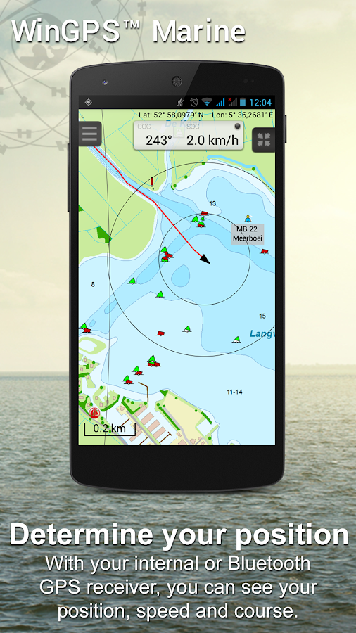


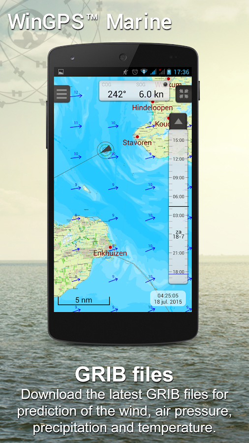

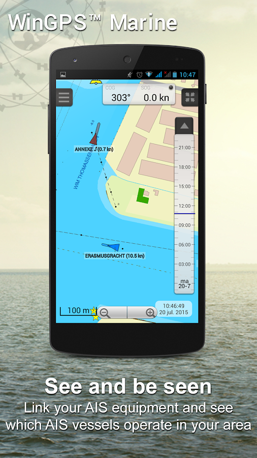

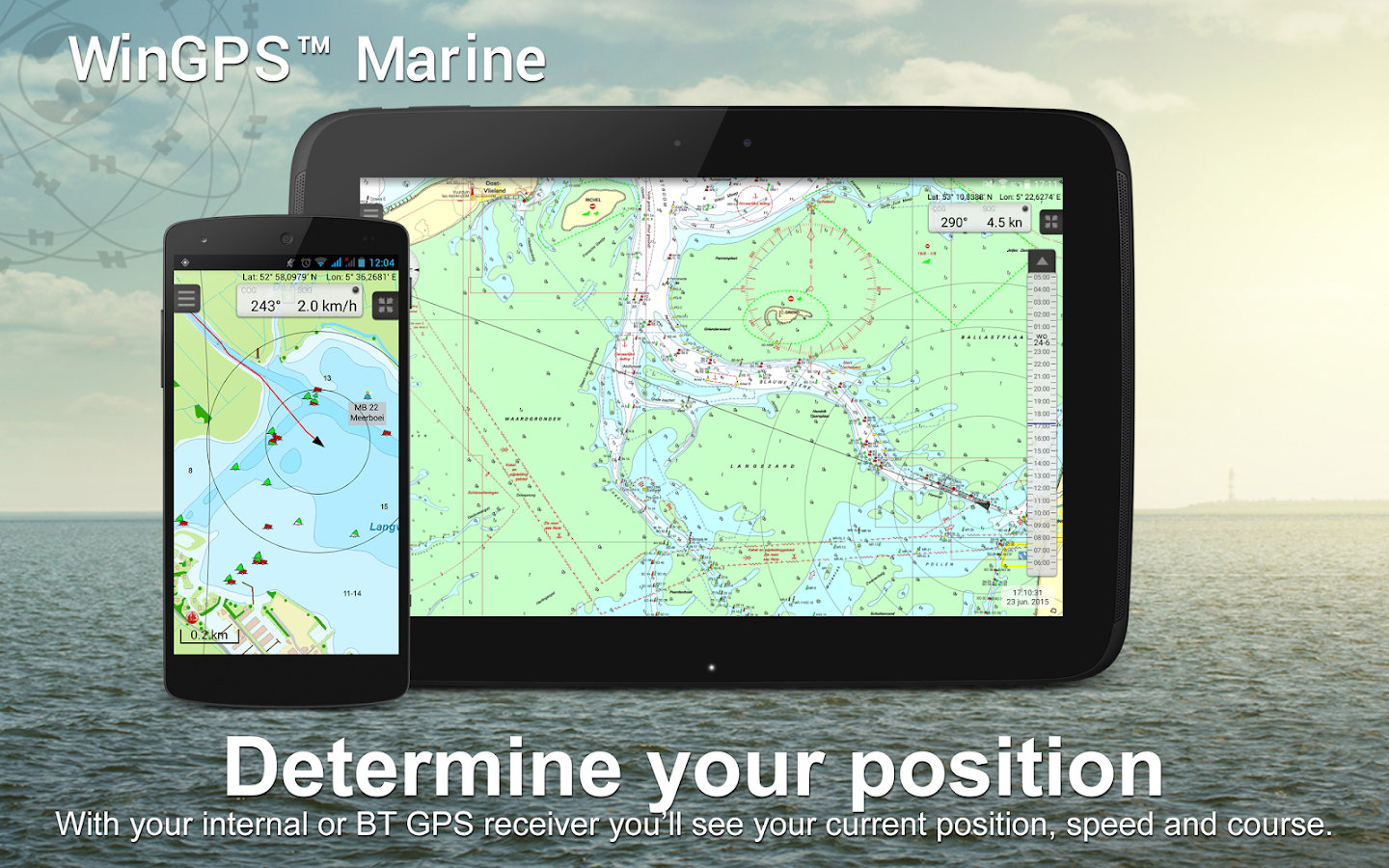


Description
App Information WinGPS™ Marine
- App NameWinGPS™ Marine
- Package Namecom.stentec.wingps_marine_lite
- UpdatedOct 25, 2023
- File SizeUndefined
- Requires AndroidAndroid 5.0
- Version4.56
- DeveloperStentec
- Installs100K+
- PriceFree
- Categoryinfo_outline</i></button></div>
- DeveloperHarinxmastraat 29 8621 BJ Heeg The Netherlands
- Google Play Link
WinGPS™ Marine Version History
Select WinGPS™ Marine Version :-
WinGPS™ Marine 4.44 APK File
Publish Date: 2022 /12/3Requires Android: Android 5.0+ (Lollipop, API: 21)File Size: 5.6 MBTested on: Android 11 (Red Velvet Cake, API: 30)File Sha1: a2772f1d5525edde1ba34e5a402096620f893270 -
WinGPS™ Marine 2.76 APK File
Publish Date: 2017 /5/5Requires Android: Android 3.1+ (Honeycomb, API: 12)File Size: 11.7 MBTested on: Android 5.1 (Lollipop, API: 22)File Sha1: 69dae9c523806b6ca707d9a9b896197412569139 -
WinGPS™ Marine 2.67 APK File
Publish Date: 2017 /1/22Requires Android: Android 3.1+ (Honeycomb, API: 12)File Size: 11.3 MBTested on: Android 5.1 (Lollipop, API: 22)File Sha1: a30b9197d22157fe79aff67ed00772190aa087b2 -
WinGPS™ Marine 2.65 APK File
Publish Date: 2016 /10/25Requires Android: Android 3.1+ (Honeycomb, API: 12)File Size: 11.4 MBTested on: Android 5.1 (Lollipop, API: 22)File Sha1: 545f10ec93a8f77f7755ff7ccc997c0bdeb27ecb -
WinGPS™ Marine 2.55 APK File
Publish Date: 2016 /9/21Requires Android: Android 3.1+ (Honeycomb, API: 12)File Size: 11.3 MBTested on: Android 5.1 (Lollipop, API: 22)File Sha1: 10779b8b5c62e28beca7f7fd2afa2fb8808cd83d -
WinGPS™ Marine 2.53 APK File
Publish Date: 2016 /8/11Requires Android: Android 3.1+ (Honeycomb, API: 12)File Size: 11.3 MBTested on: Android 5.1 (Lollipop, API: 22)File Sha1: 07d3392a45ddd0deb0ad8189916aad891e952c95 -
WinGPS™ Marine 2.45 APK File
Publish Date: 2016 /6/29Requires Android: Android 3.1+ (Honeycomb, API: 12)File Size: 11.2 MBTested on: Android 5.1 (Lollipop, API: 22)File Sha1: 46f88a8dcc193056c422fee196fa90d96da9c850 -
WinGPS™ Marine 2.43 APK File
Publish Date: 2016 /6/23Requires Android: Android 3.1+ (Honeycomb, API: 12)File Size: 11.3 MBTested on: Android 5.1 (Lollipop, API: 22)File Sha1: ee5f5cc9e893fd6083486b24d3e9a34b220da2b1 -
WinGPS™ Marine 2.31 APK File
Publish Date: 2016 /2/25Requires Android: Android 3.1+ (Honeycomb, API: 12)File Size: 11.3 MBTested on: Android 5.1 (Lollipop, API: 22)File Sha1: b67d04683cc4da0f5d4e9ad8b8255f2459b28378 -
WinGPS™ Marine 2.28 APK File
Publish Date: 2016 /1/17Requires Android: Android 3.1+ (Honeycomb, API: 12)File Size: 11.0 MBTested on: Android 5.1 (Lollipop, API: 22)File Sha1: d57e958a969fb3dcd704ec9ceb4b8afa44f6f24e
Stentec Show More...

Vaarkaart Friese Meren 2.11 APK
The perfect chart for sailing on the Frisianlakes. This chart is made for boat renters, skippers and crew ofsail boats, motor boats and barges. Also recommended for canoes andfishers.AreaFrom Stavoren to Grouw, with the following lakes:: Heegermeer,Fluessen, Morra, Oudegaster Brekken, Zwarte and Witte Brekken,Sneekermeer, Koevorden, Tjeukermeer, Langweerderwielen, andPikmeer/Wijde Ee.This is a detailed chart with a scale 1,3m/pixel. This comesdown to about 1 : 5000 on the screen.Depth viewWith clear depth view from the Friese Meren Project in well coloreddepth areas on the lakes and depth numbers along the water ways.Developed by Stentec in cooperation with the province Fryslân basedon the most recent depth measurements.WaypointsThe included database contains 2345 waypoints divided in 13 groups.The 145 marinas show phone numbers and websites. Other groups areamong others bouyage, mooring spots, campings and gas stations.The accurate positioned bouyage contains the so called‘slobbers’. These mark the protected bird area from 1 October to 1May. Outside this period these are replaced by yellow regattabuoys.Marrekrite 2014 natural mooring places are also included in thechart. You can easily see if camping is allowed (CAMP), if acontainer is present (CONT) or if you can moor (WAL).The bridges and locks along the water ways are shown with heightand width so you can easily plan your route. The many aquaducts arealso shown. Most bridges are operated daily from 1 May to 1November from 9h-19h. In June, July and August even until 20h.


DKW English east coast 2016 3.00 APK
DKW UK1 English & Scottish east coast 2016Navigation app with digital water charts for boatingandcommercial shipping. This chart set is for North Sea SailorsandEngland sailors. The coverage of this chart set is: fromDover,Orkney Islands to the Shetland Islands, with over sailors oftheNorth sea, the channel and the west of the United KingdomandIreland.Note: When purchasing this app you can use the 2015 editionofthe chart. It will automatically update the chart in the appwhenthe 2016 edition is available.What can you do with this app?• Show the current or last known position on the chart andfollowautomatically• Plot your track on the chart• Create your own waypoints• Instrument monitor with: Course over ground (COG), speedoverground (SOG), your GPS position (Lat&Lon), Course tosteer(CTS), distance to go (DTG), time to go (TTG), estimated timeofarrival (ETA) of your selected waypoint.• Automatically search for updates at startup.Why use this app?• safely navigating with the latest chart onboard.• Free summer update in July.• Sign in with your Stentec user account and use your 2ndactivationfor WinGPS on your Windows navigation laptop.• You create a backup system on board of your ship.

Vaarkaart Biesbosch 2014 1.05 APK
Recommended for water sporters, fishersandnature lovers. Also perfect for tourists and people with canoeswholike to cruise.AreaBiesbosch between Dordrecht, Werkendam, RaamsdonkveerandMoerdijk.With the following: Oude Maas, Dordtsche Kil , HollandschDiep,Amer, Bergsche Maas, Merwede.This is a detailed chart with a scale 0,8m/pixel. This comes downtoabout 1 : 3000 on the screen.Depth viewVaarkaart Biesbosch contains an unique depth view of theBiesboschbased on the most recent data Rijkswaterstaat (2013). Thedepthview is shown in several degrees (white to blue), and alsodepthnumbers in NAP.The Biesbosch can vary about 2dm thanks to tide. The averagelowwater (GLW) is 1,5dm above NAP, so the NAP depth numbers stillhavea 1,5dm.The average high (GHW) is 3,5dm above NAP.In short : Average low water is NAP + 1,5dm, and average highwateris NAP + 3,5dm.WaypointsThe included database contains 926 waypoints, of which halfisbouyage. The rest are 38 marinas with phone number andwebsite,moorings and gas stations.Bridges and locks show allowed height and width for easyrouteplanning. If available, VHF channels are also shown.

DKW German Bight 2016 3.01 APK
Navigation app with digital water chartsforboating and commercial shipping. The DKW German Bightconnectsperfectly to the “DKW 1812 – Waddenzee East” chartset.The coverage of this chart set: from Juist tot Kiel,Hamburg,Bremen, Oldenburg, Hemmoor, Helgoland and Sylt.Note: When purchasing this app you can use the 2015 editionofthe chart. It will automatically update the chart in the appwhenthe 2016 edition is available.What can you do with this app?• Show the current or last known position on the chart andfollowautomatically• Plot your track on the chart• Create your own waypoints• Instrument monitor with: Course over ground (COG), speedoverground (SOG), your GPS position (Lat&Lon), Course tosteer(CTS), distance to go (DTG), time to go (TTG), estimated timeofarrival (ETA) of your selected waypoint.• Automatically search for updates at startup.Why use this app?• safely navigating with the latest chart onboard.• Free Summer update in July.• Sign in with your Stentec user account and use your 2ndactivationfor WinGPS on your Windows navigation laptop.• The German Bight connects perfectly with the DKW 1812chartset.• You create a backup system on board of your ship.

Similar Apps Show More...


SailDroid APK
The Sailing AppApp for sailors, yachts and boats, containinga set of nautical applications:- Magnetic Compass- Speedometer in knots, mph or km/h, Course over Ground- Position- Mark or edit waypoints- Import Waypoints from gpx file- Distance measurement in nautical miles and meters. Also usefulfor anchoring.- Course to WaypointAll in large, high contrast characters


