hourglass_full Your download should start automatically in a few seconds...

Download Free Nautical Charts_Latest Version.apk from Apk-Dl Server
Thank you for using Apk-Dl.com to download the apk file (Free Nautical Charts_Latest Version.apk),
If the download doesn't start automatically in a few seconds, please click here to access the download URL directly.
Note: Download and save the apk file to your Android Phone's SD card and install it manually onto the Android device.


Description
Marine Ways Boating is the ultimate marinenavigation and planning application! In this application you willgain access to:
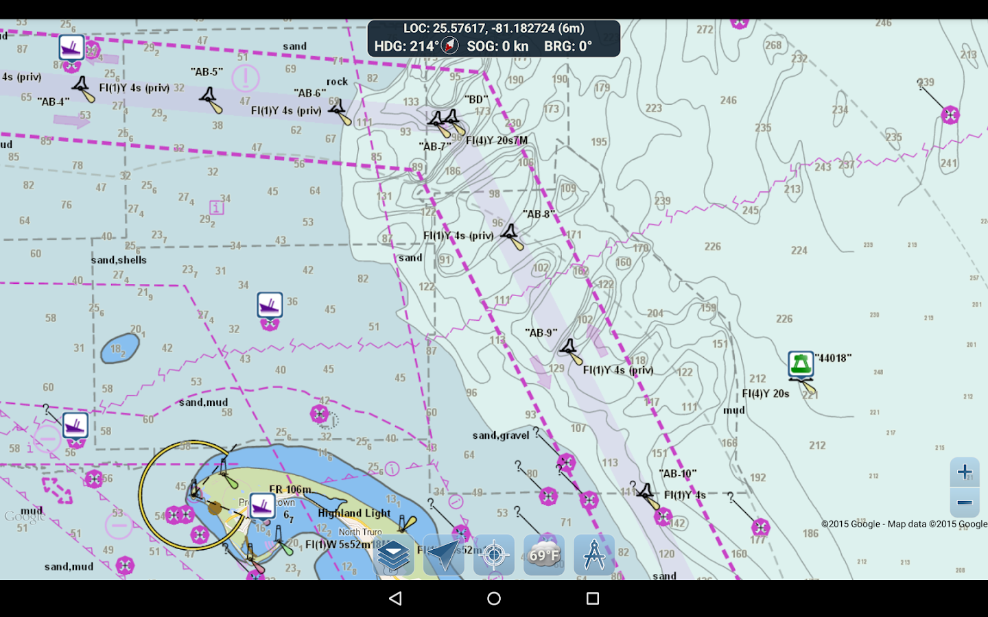
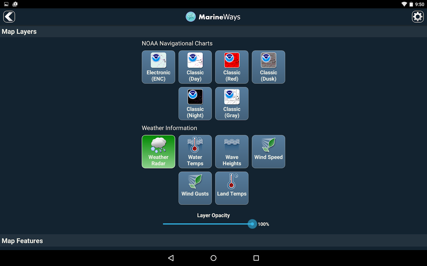
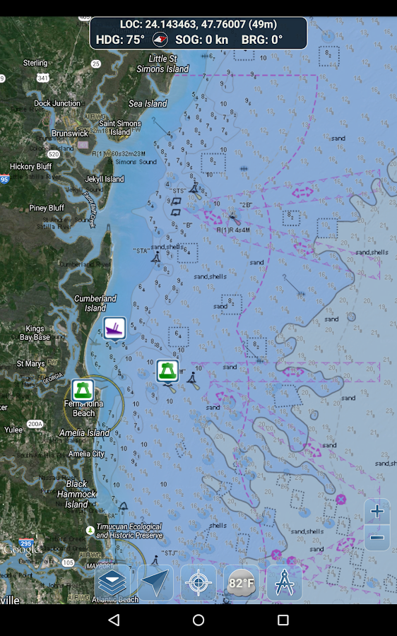
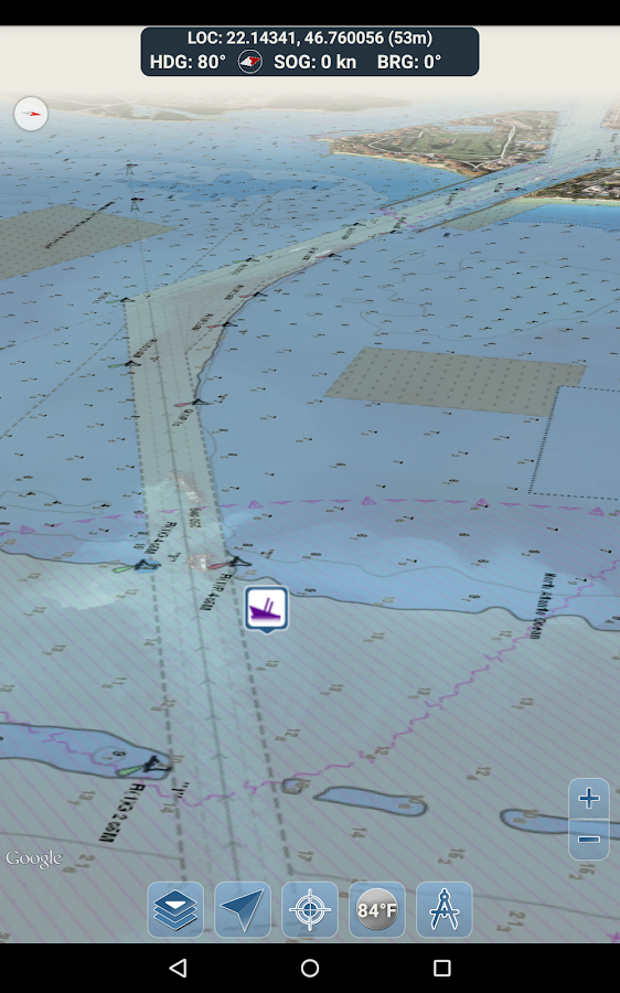
FREE NAVIGATIONAL CHARTS
- NOAA ENC Electronic Navigational Charts (NOAA's newest and mostpowerful electronic charting product)
- NOAA BSB Classic Raster Charts (including Day, Red, Dusk, Night,and Gray versions)
- All chart data is supplied by NOAA.
Just toggle the chart you want in the map settings section and itwill show up on the map! Zoom in for the finest detail!
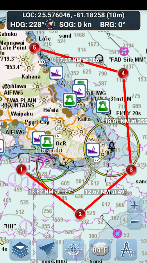
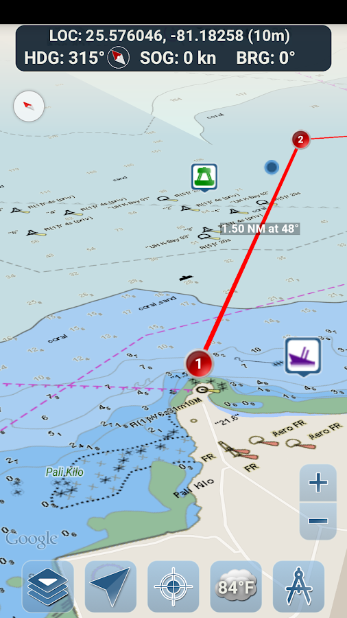
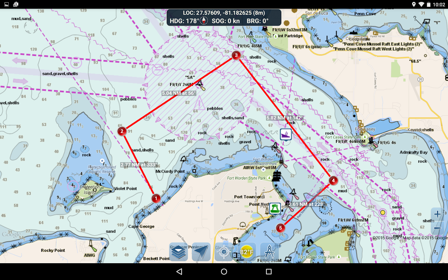
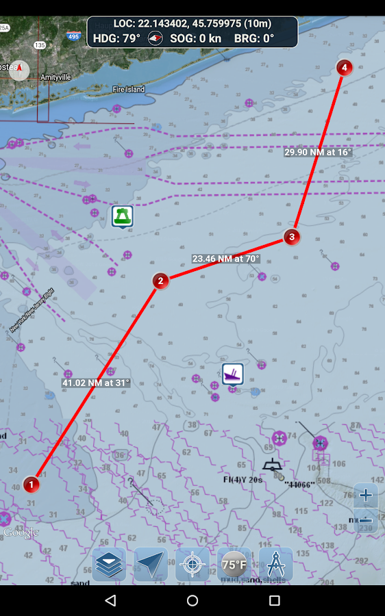
ROUTE PLANNING TOOLS
-Route Plotting. Tap and hold on the map for one second to plotyour waypoints. To form a route, continue to tap and hold on themap in different areas. Distance and bearing are convenientlycalculated and displayed for each leg as you add, adjust, or removewaypoints.
-Travel Mode. Automatically centers the map on your currentposition as you move. Use travel mode to see how closely you arefollowing your plotted route in real time!
-Route Leg Summary. A convenient view containing detailedinformation of each leg you have plotted, including start and endcoordinates, distance, and bearing.
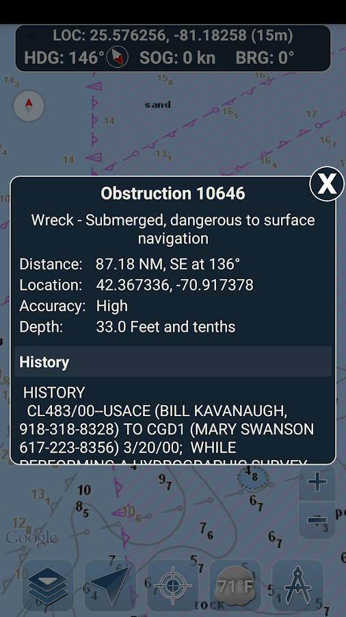
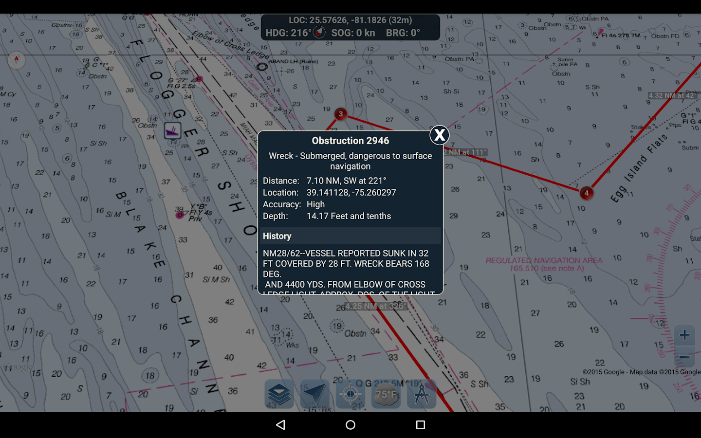
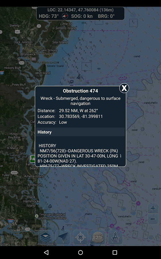
BUOY REPORTS AND OBSTRUCTION INFORMATION
Markers for buoys and obstructions are conveniently plotted intheir actual location on the map! Just click on the marker to viewtheir information!
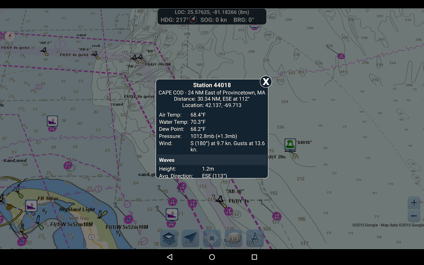
- Buoy Reports: Get complete current conditions and wave reportsfor fixed and drifting buoys.
- Obstructions: Get location and history information aboutpotentially dangerous, submerged hazards including rocks and sunkenvessels.
NAVIGATION DASHBOARD
The navigational dashboard shows various real-time informationincluding:
- Current location (latitude and longitude, with accuracyrange)
- Current Heading (includes a small directional compass aswell!)
- Current Speed Over Ground
- Current Bearing
MARINE MAP OVERLAYS
Toggle various marine overlay data right onto the map to get abetter idea of the current boating conditions!
Overlays include:
- Water Surface Temperature (Global)
- Wind Speeds (US only)
- Wind Gusts (US only)
- Wave Heights (US only)
LOCATION SHARING OVER WATER / VIEW OTHER BOATS
- Display your last known location, speed, bearing, and boat nameon the map for other Marine Ways boaters to view.
- View the last known location, speed, bearing, and boat name ofother Marine Ways boaters, as well as their distance and bearingfrom your location.
- Location sharing is turned off by default. When you are ready toshare, toggle it on within general settings. To continuously updateyour location on the map, keep the app opened and focused. The appcurrently does not update your location in the background.
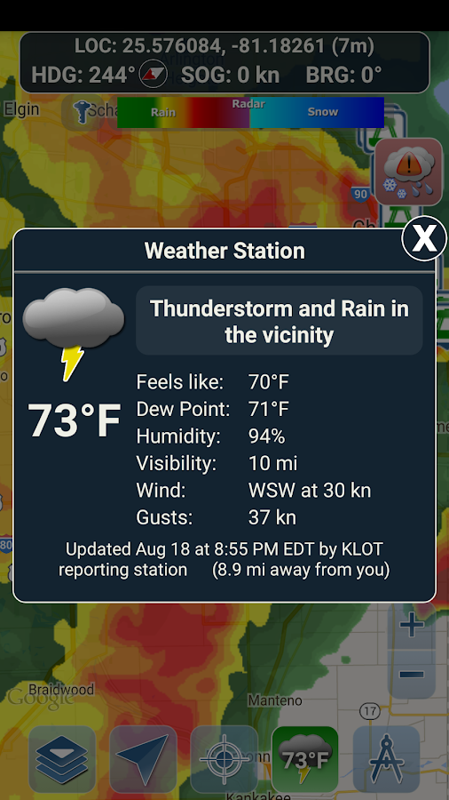
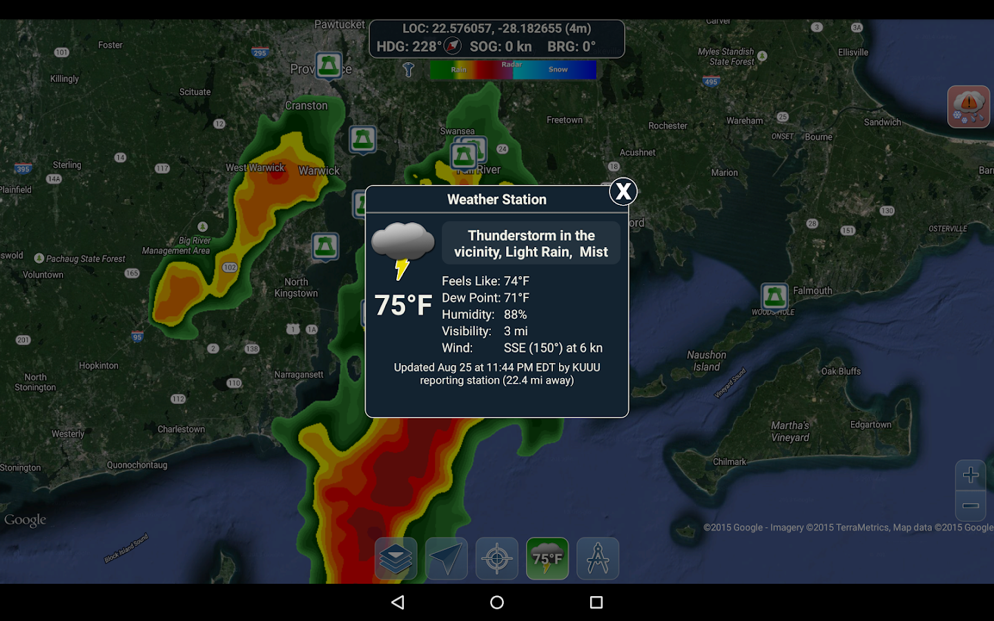
WEATHER INFORMATION
- Weather Precipitation Radar (US & Hawaii only). Detects anyrain and snow in the area.
- Weather Station. Reports the nearest observation station data.Current temperature, humidity, weather conditions, wind, and more!Station observation data is available globally.
- Weather Alerts. Weather station also reports any active weatheralerts issued by the National Weather Service such as severethunderstorm warnings or hurricane warnings. Weather alertinformation is available for US, Alaska and Hawaii.
- Land Surface Temperature overlay. Shows the current surfacetemperature on land (US only).
Before using this application, please read and agree to thefollowing terms of use / service and privacy policy:
Terms of Use / Service: http://www.marineways.com/appterms
Privacy policy: http://www.marineways.com/appprivacy
Navigational Charts Disclaimer from NOAA:
NOAA ENC Online is not certified for navigation. Screen captures ofthe ENCs displayed here do NOT fulfill chart carriage requirementsfor regulated commercial vessels under Titles 33 and 46 of the Codeof Federal Regulations.
Enjoy the app! Marine Ways is also available on the web athttp://www.marineways.com
FREE NAVIGATIONAL CHARTS
- NOAA ENC Electronic Navigational Charts (NOAA's newest and mostpowerful electronic charting product)
- NOAA BSB Classic Raster Charts (including Day, Red, Dusk, Night,and Gray versions)
- All chart data is supplied by NOAA.
Just toggle the chart you want in the map settings section and itwill show up on the map! Zoom in for the finest detail!
ROUTE PLANNING TOOLS
-Route Plotting. Tap and hold on the map for one second to plotyour waypoints. To form a route, continue to tap and hold on themap in different areas. Distance and bearing are convenientlycalculated and displayed for each leg as you add, adjust, or removewaypoints.
-Travel Mode. Automatically centers the map on your currentposition as you move. Use travel mode to see how closely you arefollowing your plotted route in real time!
-Route Leg Summary. A convenient view containing detailedinformation of each leg you have plotted, including start and endcoordinates, distance, and bearing.
BUOY REPORTS AND OBSTRUCTION INFORMATION
Markers for buoys and obstructions are conveniently plotted intheir actual location on the map! Just click on the marker to viewtheir information!
- Buoy Reports: Get complete current conditions and wave reportsfor fixed and drifting buoys.
- Obstructions: Get location and history information aboutpotentially dangerous, submerged hazards including rocks and sunkenvessels.
NAVIGATION DASHBOARD
The navigational dashboard shows various real-time informationincluding:
- Current location (latitude and longitude, with accuracyrange)
- Current Heading (includes a small directional compass aswell!)
- Current Speed Over Ground
- Current Bearing
MARINE MAP OVERLAYS
Toggle various marine overlay data right onto the map to get abetter idea of the current boating conditions!
Overlays include:
- Water Surface Temperature (Global)
- Wind Speeds (US only)
- Wind Gusts (US only)
- Wave Heights (US only)
LOCATION SHARING OVER WATER / VIEW OTHER BOATS
- Display your last known location, speed, bearing, and boat nameon the map for other Marine Ways boaters to view.
- View the last known location, speed, bearing, and boat name ofother Marine Ways boaters, as well as their distance and bearingfrom your location.
- Location sharing is turned off by default. When you are ready toshare, toggle it on within general settings. To continuously updateyour location on the map, keep the app opened and focused. The appcurrently does not update your location in the background.
WEATHER INFORMATION
- Weather Precipitation Radar (US & Hawaii only). Detects anyrain and snow in the area.
- Weather Station. Reports the nearest observation station data.Current temperature, humidity, weather conditions, wind, and more!Station observation data is available globally.
- Weather Alerts. Weather station also reports any active weatheralerts issued by the National Weather Service such as severethunderstorm warnings or hurricane warnings. Weather alertinformation is available for US, Alaska and Hawaii.
- Land Surface Temperature overlay. Shows the current surfacetemperature on land (US only).
Before using this application, please read and agree to thefollowing terms of use / service and privacy policy:
Terms of Use / Service: http://www.marineways.com/appterms
Privacy policy: http://www.marineways.com/appprivacy
Navigational Charts Disclaimer from NOAA:
NOAA ENC Online is not certified for navigation. Screen captures ofthe ENCs displayed here do NOT fulfill chart carriage requirementsfor regulated commercial vessels under Titles 33 and 46 of the Codeof Federal Regulations.
Enjoy the app! Marine Ways is also available on the web athttp://www.marineways.com