


Description
App Information Vaarkaart Biesbosch 2014
- App NameVaarkaart Biesbosch 2014
- Package Namecom.stentec.dkwregio_bi14
- UpdatedJune 5, 2014
- File SizeUndefined
- Requires AndroidAndroid 2.3 and up
- Version1.05
- DeveloperStentec
- Installs100 - 500
- Price$9.43
- CategoryTravel & Local
- Developer
- Google Play Link
Stentec Show More...

Vaarkaart Friese Meren 2.11 APK
The perfect chart for sailing on the Frisianlakes. This chart is made for boat renters, skippers and crew ofsail boats, motor boats and barges. Also recommended for canoes andfishers.AreaFrom Stavoren to Grouw, with the following lakes:: Heegermeer,Fluessen, Morra, Oudegaster Brekken, Zwarte and Witte Brekken,Sneekermeer, Koevorden, Tjeukermeer, Langweerderwielen, andPikmeer/Wijde Ee.This is a detailed chart with a scale 1,3m/pixel. This comesdown to about 1 : 5000 on the screen.Depth viewWith clear depth view from the Friese Meren Project in well coloreddepth areas on the lakes and depth numbers along the water ways.Developed by Stentec in cooperation with the province Fryslân basedon the most recent depth measurements.WaypointsThe included database contains 2345 waypoints divided in 13 groups.The 145 marinas show phone numbers and websites. Other groups areamong others bouyage, mooring spots, campings and gas stations.The accurate positioned bouyage contains the so called‘slobbers’. These mark the protected bird area from 1 October to 1May. Outside this period these are replaced by yellow regattabuoys.Marrekrite 2014 natural mooring places are also included in thechart. You can easily see if camping is allowed (CAMP), if acontainer is present (CONT) or if you can moor (WAL).The bridges and locks along the water ways are shown with heightand width so you can easily plan your route. The many aquaducts arealso shown. Most bridges are operated daily from 1 May to 1November from 9h-19h. In June, July and August even until 20h.


DKW English east coast 2016 3.00 APK
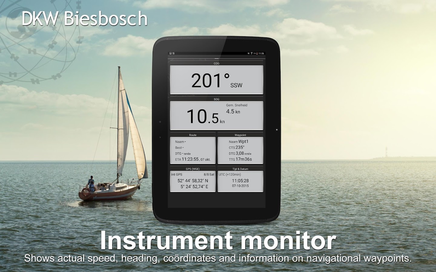
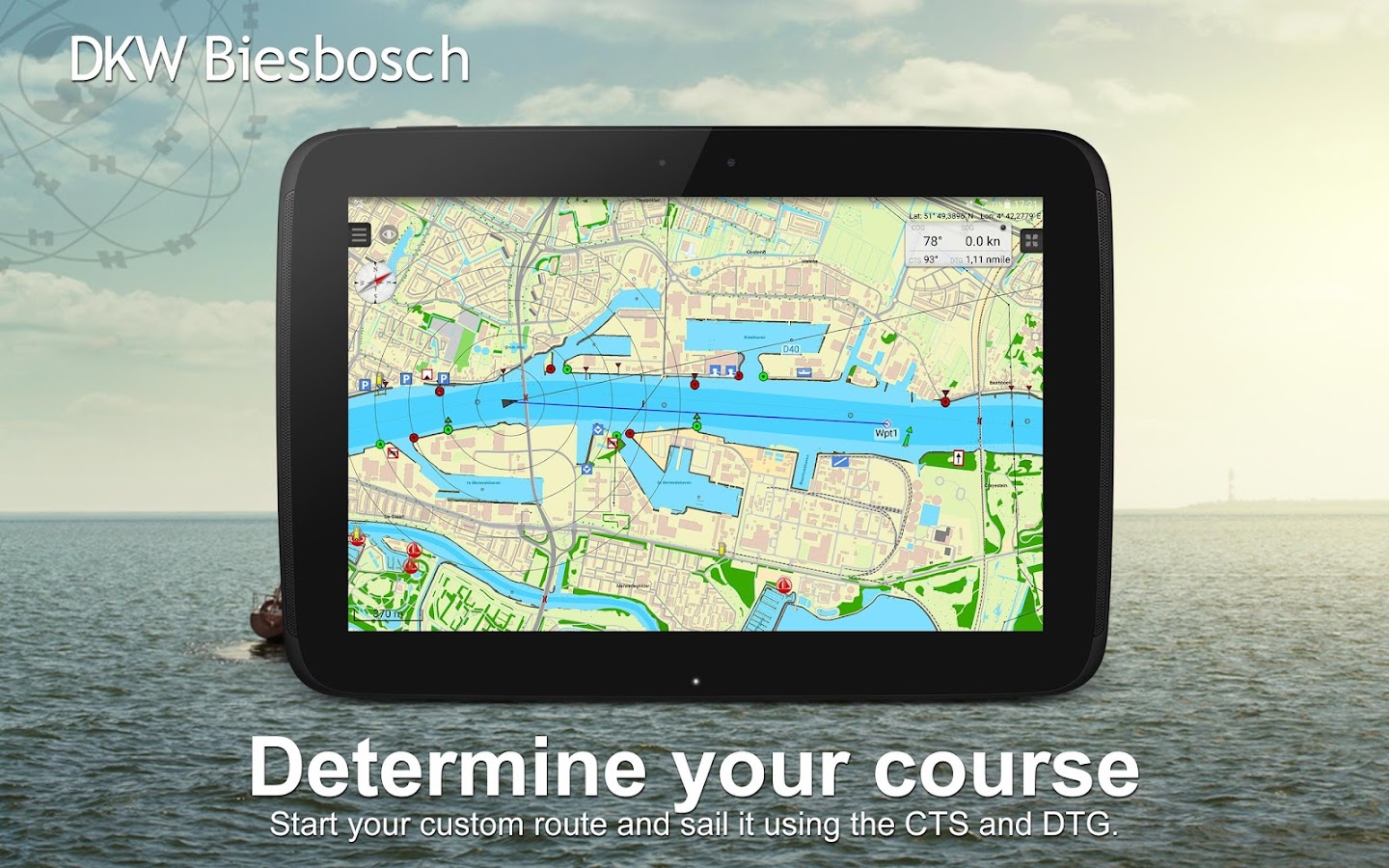
DKW UK1 English & Scottish east coast 2016Navigation app with digital water charts for boatingandcommercial shipping. This chart set is for North Sea SailorsandEngland sailors. The coverage of this chart set is: fromDover,Orkney Islands to the Shetland Islands, with over sailors oftheNorth sea, the channel and the west of the United KingdomandIreland.Note: When purchasing this app you can use the 2015 editionofthe chart. It will automatically update the chart in the appwhenthe 2016 edition is available.What can you do with this app?• Show the current or last known position on the chart andfollowautomatically• Plot your track on the chart• Create your own waypoints• Instrument monitor with: Course over ground (COG), speedoverground (SOG), your GPS position (Lat&Lon), Course tosteer(CTS), distance to go (DTG), time to go (TTG), estimated timeofarrival (ETA) of your selected waypoint.• Automatically search for updates at startup.Why use this app?• safely navigating with the latest chart onboard.• Free summer update in July.• Sign in with your Stentec user account and use your 2ndactivationfor WinGPS on your Windows navigation laptop.• You create a backup system on board of your ship.

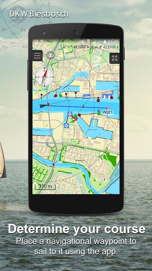
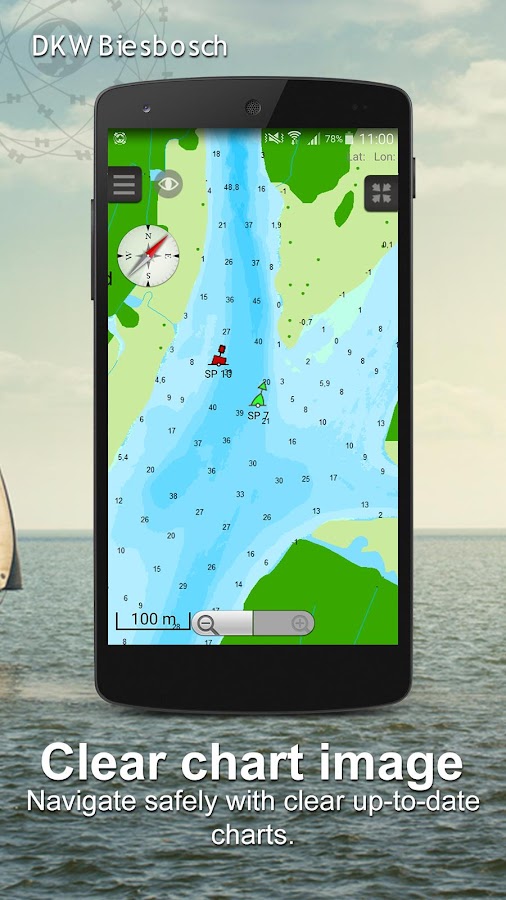
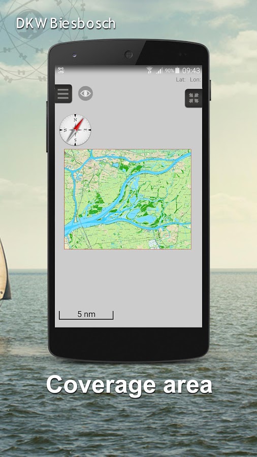
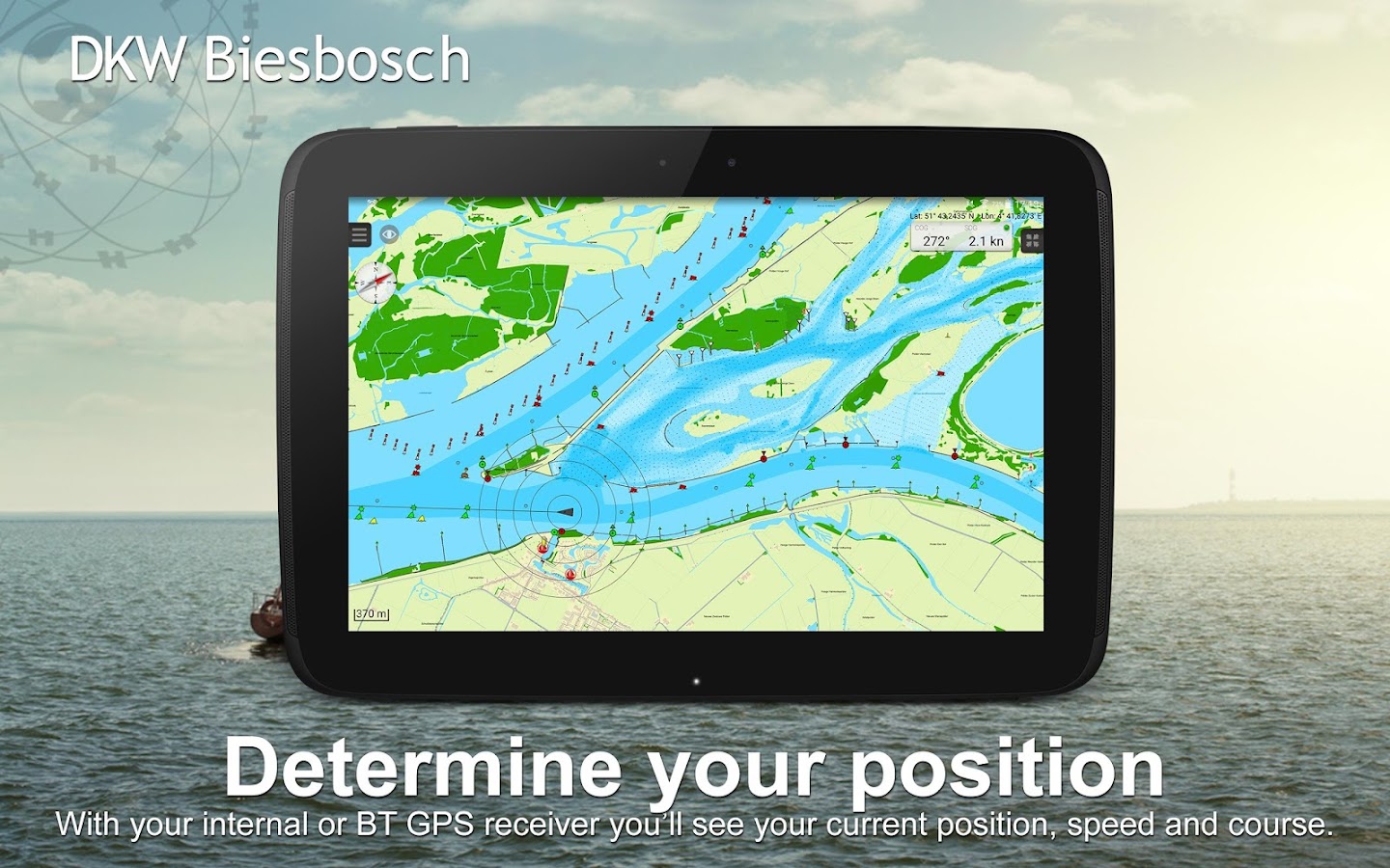
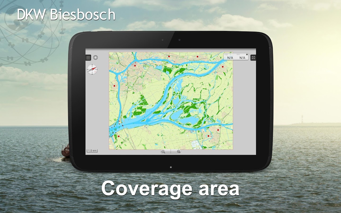
Vaarkaart Biesbosch 2014 1.05 APK
Recommended for water sporters, fishersandnature lovers. Also perfect for tourists and people with canoeswholike to cruise.AreaBiesbosch between Dordrecht, Werkendam, RaamsdonkveerandMoerdijk.With the following: Oude Maas, Dordtsche Kil , HollandschDiep,Amer, Bergsche Maas, Merwede.This is a detailed chart with a scale 0,8m/pixel. This comes downtoabout 1 : 3000 on the screen.Depth viewVaarkaart Biesbosch contains an unique depth view of theBiesboschbased on the most recent data Rijkswaterstaat (2013). Thedepthview is shown in several degrees (white to blue), and alsodepthnumbers in NAP.The Biesbosch can vary about 2dm thanks to tide. The averagelowwater (GLW) is 1,5dm above NAP, so the NAP depth numbers stillhavea 1,5dm.The average high (GHW) is 3,5dm above NAP.In short : Average low water is NAP + 1,5dm, and average highwateris NAP + 3,5dm.WaypointsThe included database contains 926 waypoints, of which halfisbouyage. The rest are 38 marinas with phone number andwebsite,moorings and gas stations.Bridges and locks show allowed height and width for easyrouteplanning. If available, VHF channels are also shown.

DKW German Bight 2016 3.01 APK
Navigation app with digital water chartsforboating and commercial shipping. The DKW German Bightconnectsperfectly to the “DKW 1812 – Waddenzee East” chartset.The coverage of this chart set: from Juist tot Kiel,Hamburg,Bremen, Oldenburg, Hemmoor, Helgoland and Sylt.Note: When purchasing this app you can use the 2015 editionofthe chart. It will automatically update the chart in the appwhenthe 2016 edition is available.What can you do with this app?• Show the current or last known position on the chart andfollowautomatically• Plot your track on the chart• Create your own waypoints• Instrument monitor with: Course over ground (COG), speedoverground (SOG), your GPS position (Lat&Lon), Course tosteer(CTS), distance to go (DTG), time to go (TTG), estimated timeofarrival (ETA) of your selected waypoint.• Automatically search for updates at startup.Why use this app?• safely navigating with the latest chart onboard.• Free Summer update in July.• Sign in with your Stentec user account and use your 2ndactivationfor WinGPS on your Windows navigation laptop.• The German Bight connects perfectly with the DKW 1812chartset.• You create a backup system on board of your ship.

Similar Apps Show More...


VaarWater 3.1.2 APK
VaarWater is still the ultimate app forboating in and around Amsterdam. Download now the new, improvedversion. Use it to keep up with the latest news about boatingroutes and events, and to get updated reports. The app has a newcompass feature, which shows you what there is to see and do inyour vicinity. Find out where one-way traffic restrictions apply,locate the best places to moor your boat, and discover restaurantsthat are situated beside the water. The app is now available inEnglish.
Travel & Local Top Show More...

Flightradar24 - Flight Tracker 6.7.1 APK
Turn your phone or tablet into anairtrafficradar and see planes around the world move in real-timeonadetailed map. Or point your Android device at a plane in theskytofind out where it’s going and more. Discover today whymillionsarealready using Flightradar24 - Flight Tracker.Features that have helped make Flightradar24 - FlightTrackerthe#1 selling app in 100+ countries and the #1 Travel appin140+countries (United States, France, United Kingdom, Germanyandmore)include:* Watch planes move in real-time on detailed map* Identify planes flying overhead by simply pointing yourdeviceatthe sky (the augmented reality view requiresrearcamera,accelerometer & magnetic sensor)* Experience what the pilot of a an aircraft sees in real-timeandin3D* Tap on a plane for comprehensive flight andaircraftinformationsuch as route, estimated time of arrival, actualtime ofdeparture,aircraft type, speed, altitude, andhigh-resolutionpicture* Easy to search for individual flights using flightnumber,airport,or airline* Easy to filter by airline, aircraft, altitude,speed,andmore* Easy to set bookmarks to enable quick navigation toareasofinterest* Turn the device into the arrivals and departures board ofanymajorairport and get real-time status updates for flightspluscurrentairport weather conditions (in-app purchase)* Realistic aircraft symbols (in-app purchase)* Set up custom alerts based on airline, aircraft type,flightnumberor registration (in-app purchase)HOW IT WORKSMost aircraft are equipped with so called ADS-Btranspondersthattransmit positional data. Flightradar24 has arapidlygrowingnetwork of several thousand ground stations aroundthe worldtoreceive this data that then shows up as aircraft movingon a mapinthe app. In an expanding number of regions Flightradar24,withthehelp of multilateration, is able to calculate thepositionsofaircraft that don’t have ADS-B transponders.Traditional radar data is also used in the app thanks toadirectfeed from the US Federal Aviation Administration (FAA).http://www.flightradar24.com/how-it-works***IMPORTANT NOTICES***Minimum required screen resolution is 320x480px.If you are only interested in tracking air traffic inaspecificregion, we suggest that you checkFlightradar24.comBEFOREpurchasing the app. Flightradar24 providesunrivaledpositionalaircraft data coverage around the world butthere areareas wherewe don’t have coverage.Overview of coverage as of January 2016:* Europe: close to 100%* North America: 100% of US and Canada via slightlydelayedradardata. Real-time coverage for most of US, Canada andMexicoforADS-B equipped aircraft* South America: Substantial coverage in mostcountriesincludingArgentina, Bolivia, Brazil, Chile, Colombia,EcuadorandVenezuela.* Asia: Substantial coverage in most major AsiancountriesincludingJapan, India, Indonesia, South Korea, Thailand,UAE,Malaysia,Taiwan and many other countries. Rapidlyexpandingcoverage inChina* Oceania: Nearly complete coverage in AustraliaandNewZealand* Africa: Substantial coverage in Africa with coverageexpandingallthe time.Find out how you can help:http://www.flightradar24.com/increase-coverageCoverage is subject to change at any time.HELP & SUPPORTforum.flightradar24.com/threads/89-Important-Read-this-before-you-ask-questionsflightradar24.com/contact-us.DISCLAIMERThe use of this app is strictly limited toentertainmentpurposes.This specifically excludes activities thatmight endangeryourselfor the lives of others. Under nocircumstances will thedeveloperof this app be held responsible forincidents resultingfrom theuse of the data or its interpretation orits use contraryto thisagreement. We reserve the right toanonymously track andreport auser's activity inside of app.

MOFA KSA 2.5.5 APK
يعد تطبيق وزارة الخارجيةالسعوديةللأجهزةالذكيةهو أحد قنوات الوصول لخدمات الوزارة والتي منخلالهيمكن تنفيذمجموعةمن الخدمات التي تستهدف شرائح مختلفة منالمستفيدين(أفراد،أعمال،وحكومة) كما يتم تحديث التطبيق بشكل دوريبمجموعة منالخدماتالجديدةوالتحسينات التي من شانها رفع مستوى الرضالدىالمستفيدين منخدماتالوزارة.تنفيذ وتطوير التطبيق:تم تطوير التطبيق من قبل الإدارةالعامةلتقنيةالمعلوماتوالاتصالاتالدعم الفني والاقتراحات:يرجى تعبئة الاستبيان الموجود ضمن مشاركاتإلكترونية-استبيانتطبيقالأجهزة الذكية أو مراسلتناعلىالبريدالإلكتروني[email protected]

MakeMyTrip Hotel Extranet 5.0.0 APK
Hoteliers, this one is foryou!MakeMyTrippresents the exclusive Hotel Extranet mobileappspecially designedto keep your hotel details up-to-date.With this app, you can:• Have access to day-wise / calendar view of your hotelrates&inventory• Update your hotel rates & inventory day-wise as well asforalonger period of time• Update ALL your tariffs’ inventory in just 2 steps• Track your important business metrics(likeCheck-InsToday/Tomorrow, Room Night Check-Ins in next 30 days,SoldOut innext 90 days etc.)• Keep a track of all your bookings & also takenecessaryactionslike Confirm a booking, Mark Check-In/No Show fora Pay AtHotelbooking• View complete details of a booking (including the voucher)• Call a Pay At Hotel customer with a single tap• Manage your Hotel Promotions in quick & easy waywithanability to create new promotions• Keep a track of your Payments• View help video tutorials to understand the utilityofourapp• Push Notifications to help you with Sold Out days &summaryofyour BookingsHotel Extranet will set you free from long chain mailsandphonecalls. No matter where you are, you can keep yourhoteldetailsfresh within a few easy steps.Also, there is lot more to come, which will make yourlifeeveneasier!

hottel - Hotel Booking 4.1.20 APK
Everyday hotels give us last-minutediscountsontheir available rooms.Best prices are guaranteed.Hotels are hand-picked to meet your expectation.10 seconds to book a roomPay less enjoy more.8:00 - 24:00 every night we are ready.Contact [email protected]