


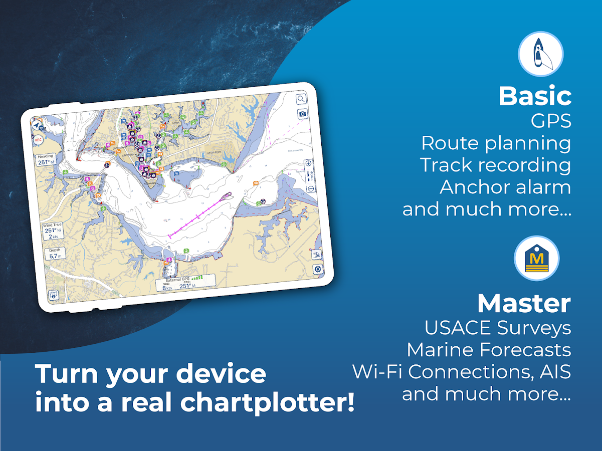
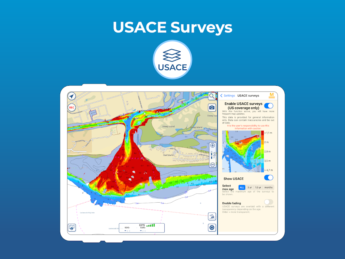
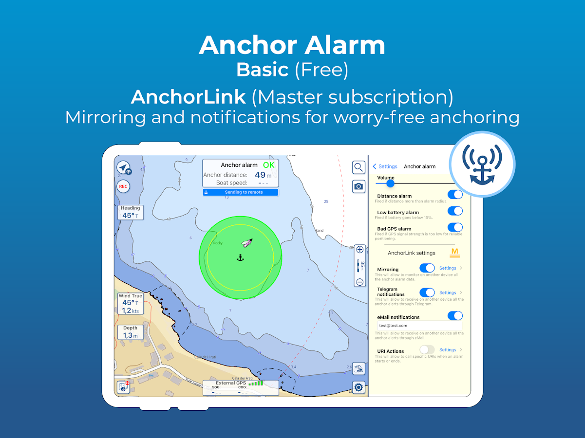


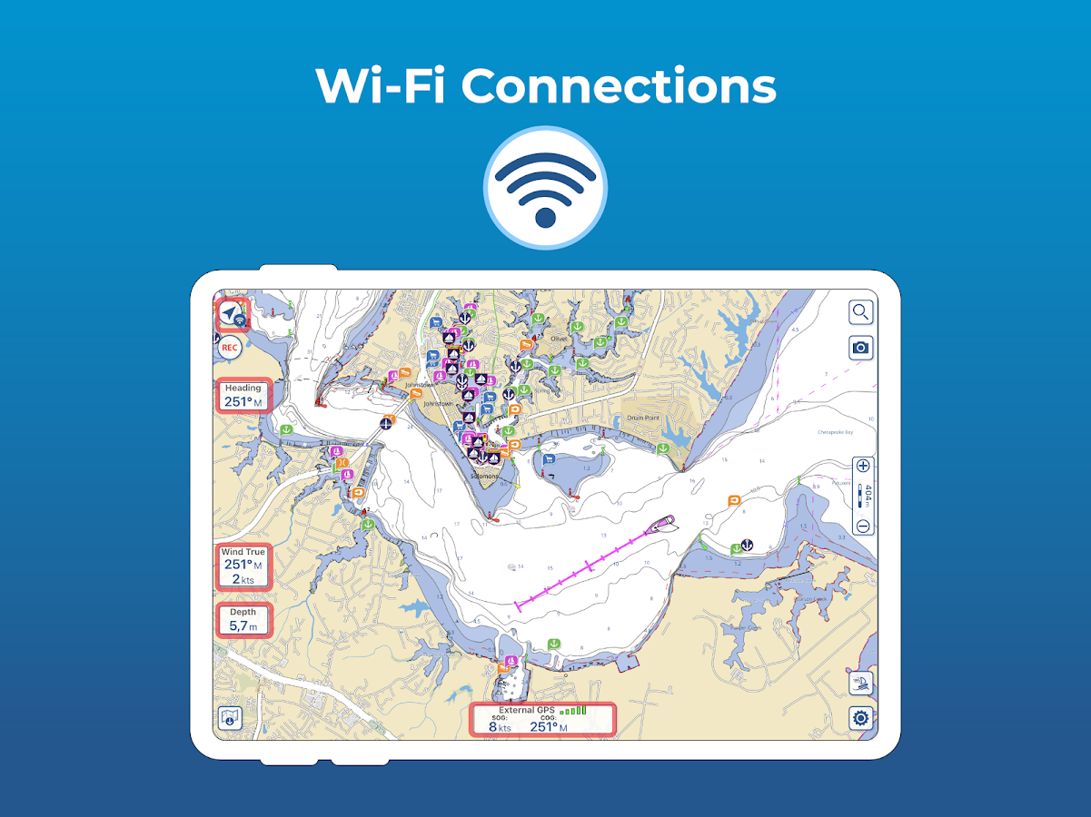
Description
App Information Aqua Map - Mobile Chartplotter
- App NameAqua Map - Mobile Chartplotter
- Package Namecom.gec.MarineApp.WorldViewerLite
- UpdatedOct 30, 2023
- File SizeUndefined
- Requires AndroidAndroid 6.0
- Version25.4
- DeveloperGEC srl
- Installs100K+
- PriceFree
- Categoryinfo_outline</i></button></div>
- DeveloperVia Monte Matanna 1/C
- Google Play Link
Aqua Map - Mobile Chartplotter Version History
Select Aqua Map - Mobile Chartplotter Version :-
Aqua Map - Mobile Chartplotter 21.7 APK File
Publish Date: 2022 /12/3Requires Android: Android 6.0+ (Marshmallow, API: 23)File Size: 79.8 MBTested on: Android 12 (Snow Cone, API: 31)File Sha1: 6fa9717c5de2d483722f39c33bf5b1265b2af9a2
GEC srl Show More...

Aqua Map Seychelles - GPS 5.0 APK
*** New exclusive function: mapXpan ***An app to satisfy all your Traveling, Fishing and Boating's needs,developed with the help of professional fishermen.You will be able to download the best nautical and land charts ofSeychelles and enjoy your navigation and travel. Press the RECORDbutton, put the phone in your pocket and record your fishingtrolling track....and much more.►► Features:• Amazingly clear maps.• User friendly interface.• You can download maps (for FREE, no additional purchase isrequired) on the device, to be used later without any internetconnection.• Complete Coverage of Seychelles region at the best details,marine and land charts• *** NEW *** Expand your horizons with mapXpan (patentpending).• Store your track without the need of cellular data or phonesignal.• No problem to receive/make phone calls and messages whilerecording the tracks.• Share tracks, markers and pictures in various formats (KMZ andGPX).• Store an unlimited number of tracks and markers.• Customize your Marker's icon and Track's color.• Switch between Map display modes (Offline, Satellite,Roads).• Measure distances on the map.• Play your track animation on Google Maps™ and Google Earth™ (KMZtracks).• Load any track and marker from internet communities (KMZ, KML,GPX also if zipped)• Query map objects with your finger tip*** NEW ***► mapXpanThis new mode will greatly extend your display; you will have thedetails you need for a safe navigation seamlessly integrated with alarge overview area.Using this new mode you will see a map 64 times larger than thestandard mode without losing any detail in the center part of thescreen.► iOS BACKGROUND MODEAqua Map works also when in background, you can receive/make callsand messages while the track recording is running.► MAPSAqua Map lets you download - for FREE!! - the best Nautical chartsderived from UKHO data, with depth contours, buoys, lights, etc.and all it is necessary to enjoy your best fishing experience. Acomplete land charts with roads tracks, and important places isalso included. No additional purchase is required. With anamazingly clear display at all zoom levels, you can download themaps at home within your device and then use them on the boatwithout any Internet connection need.► SHARINGWhy do not sharing your favorite's markers sending an email withyour last daily track, with all the pictures you captured to showthem on Earth or Maps ? With Aqua Map it is just a click.► LOADING OTHER's TRACKS AND MARKERSAqua Map can load any KML, KMZ, GPX (also zipped) you can find overthe internet or received from your friends. You can load tracks andmarkers generated from any application (e.g. Google EarthTM, Maps,or other mobile apps), obviously including Aqua Map, or any device(e.g. Garmin Etrex, Nuvi, Magellan, etc.).————Like any GPS, the signal quality can vary very much depending bythe amount of visible sky, foliage, weather condition, etc. GPS isnot reliable indoor.The continuous GPS usage, also in background, can drasticallyreduce the battery life.For more information please visit our website at:www.globalaquamaps.com or send us an email at:[email protected]


Aqua Map Maldives - GPS 5.0 APK
*** New exclusive function: mapXpan ***An app to satisfy all your Traveling, Fishing and Boating's needs,developed with the help of professional fishermen.You will be able to download the best nautical and land charts ofMaldives and enjoy your navigation and travel. Press the RECORDbutton, put the phone in your pocket and record your fishingtrolling track....and much more.►► Features:• Amazingly clear maps.• User friendly interface.• You can download maps (for FREE, no additional purchase isrequired) on the device, to be used later without any internetconnection.• Complete Coverage of Maldives region at the best details, marineand land charts• *** NEW *** Expand your horizons with mapXpan (patentpending).• Store your track without the need of cellular data or phonesignal.• No problem to receive/make phone calls and messages whilerecording the tracks.• Share tracks, markers and pictures in various formats (KMZ andGPX).• Store an unlimited number of tracks and markers.• Customize your Marker's icon and Track's color.• Switch between Map display modes (Offline, Satellite,Roads).• Measure distances on the map.• Play your track animation on Google Maps™ and Google Earth™ (KMZtracks).• Load any track and marker from internet communities (KMZ, KML,GPX also if zipped)• Query map objects with your finger tip*** NEW ***► mapXpanThis new mode will greatly extend your display; you will have thedetails you need for a safe navigation seamlessly integrated with alarge overview area.Using this new mode you will see a map 64 times larger than thestandard mode without losing any detail in the center part of thescreen.► iOS BACKGROUND MODEAqua Map works also when in background, you can receive/make callsand messages while the track recording is running.► MAPSAqua Map lets you download - for FREE!! - the best Nautical chartsderived from UKHO data, with depth contours, buoys, lights, etc.and all it is necessary to enjoy your best fishing experience. Acomplete land charts with roads tracks, and important places isalso included. No additional purchase is required. With anamazingly clear display at all zoom levels, you can download themaps at home within your device and then use them on the boatwithout any Internet connection need.► SHARINGWhy do not sharing your favorite's markers sending an email withyour last daily track, with all the pictures you captured to showthem on Earth or Maps ? With Aqua Map it is just a click.► LOADING OTHER's TRACKS AND MARKERSAqua Map can load any KML, KMZ, GPX (also zipped) you can find overthe internet or received from your friends. You can load tracks andmarkers generated from any application (e.g. Google EarthTM, Maps,or other mobile apps), obviously including Aqua Map, or any device(e.g. Garmin Etrex, Nuvi, Magellan, etc.).————Like any GPS, the signal quality can vary very much depending bythe amount of visible sky, foliage, weather condition, etc. GPS isnot reliable indoor.The continuous GPS usage, also in background, can drasticallyreduce the battery life.For more information please visit our website at:www.globalaquamaps.com or send us an email at:[email protected]

Aqua Map Bahamas - GPS 5.0 APK
*** New exclusive function: mapXpan ***An app to satisfy all your Fishing and Boating's needs, developedwith the help of professional fishermen.You will be able to download the best nautical charts and enjoyyour new fishing season. Press the RECORD button, put the phone inyour pocket and record your fishing trolling track....and muchmore.►► Features:• Nautical raster charts from Wavey Line, perfectly represented andautomatically selected at each zoom level to offer a seamlesscoverage for navigation• User friendly interface.• You can download maps (for FREE, no additional purchase isrequired) on the device, to be used later without any internetconnection.• Full coverage of charts of Bahamas received by Wavey Line• *** NEW *** Expand your horizons with mapXpan (patentpending).• Store your track without the need of cellular data or phonesignal.• No problem to receive/make phone calls and messages whilerecording the tracks.• Share tracks, markers and pictures in various formats (KMZ andGPX).• Store an unlimited number of tracks and markers.• Customize your Marker's icon and Track's color.• Measure distances on the map.• Load any track and marker from internet communities (KMZ, KML,GPX also if zipped)• ActiveCaptain community integration*** NEW ***► mapXpanThis new mode will greatly extend your display; you will have thedetails you need for a safe navigation seamlessly integrated with alarge overview area.Using this new mode you will see a map 64 times larger than thestandard mode without losing any detail in the center part of thescreen.► MAPSAqua Map lets you download - for FREE!! - the best charts derivedfrom the material received from Wavey Line with their permission;all Nautical Raster Charts, have been prepared to offer a seamlesscoverage of the area. No additional purchase is required. You candownload the maps at home within your device and then use them onthe boat without any Internet connection. Check our Nautical chartsat: http://www.globalaquamaps.com/AquaMarine.html#Bahamas► SHARINGWhy do not sharing your favorite's markers sending an email withyour last daily track, with all the pictures you captured to showthem to your friends ? With Aqua Map it is just a click.► LOADING OTHER's TRACKS AND MARKERSAqua Map can load any KML, KMZ, GPX (also zipped) you can find overthe internet or received from your friends. You can load tracks andmarkers generated from any application (e.g. Google EarthTM, Maps,or other iPhone/iPad apps), obviously including Aqua Map, or anydevice (e.g. Garmin Etrex, Nuvi, Magellan, etc.).► ENJOY ActiveCaptain CommunityJoin the community of more than 100.000 boaters who write reviews,update data and provide up to date hazard information onActiveCaptainView and contribute to the best marinas location database in theworldRead and contribute reviews and rating about marinas, shared localboating knowledge, anchorage and hazards————Like any GPS, the signal quality can vary very much depending bythe amount of visible sky, foliage, weather condition, etc. GPS isnot reliable indoor.The continuous GPS usage, also in background, can drasticallyreduce the battery life.For more information please visit our website at:www.globalaquamaps.com or send us an email at:[email protected]

Aqua Map North Dakota Lakes 5.0 APK
*** New exclusive function: mapXpan ***An app to satisfy all your Fishing and Boating's needs, developedwith the help of professional fishermen.► CHECK YOUR LAKE HERE BEFORE YOU BUY:http://www.globalaquamaps.com/NDviewer.htmlYou will be able to download the best maps and enjoy your newfishing season. Press the RECORD button, put the phone in yourpocket and record your fishing trolling track....and muchmore.►► Features:• Amazingly clear maps.• User friendly user interface.• 210 North Dakota lakes available, plus a complete topographic mapto reach the most remote lakes and rivers.• You can download the maps (for FREE, no additional purchase isrequired)) on the device, to be used later without any internetconnection.• *** NEW *** Expand your horizons with mapXpan (patentpending).• Store your tracks and markers without the need of cellular dataor phone signal.• Share tracks, markers and pictures in various formats (KMZ andGPX).• ActiveCaptain community integration.• No problem to receive/make phone calls and messages whilerecording the tracks.• Store an unlimited number of tracks and markers.• Customize your Marker's icon and Track's color.• Load any track and marker from internet communities (KMZ,GPX)• Switch between Map display modes (Offline, Satellite,Roads).• Query map objects with your finger tip.*** NEW ***► mapXpanThis new mode will greatly extend your display; you will have thedetails you need for a safe navigation seamlessly integrated with alarge overview area.Using this new mode you will see a map 64 times larger than thestandard mode without losing any detail in the center part of thescreen.► MAPSAqua Map lets you download the best maps with depth contours, boatramps, etc. but also a complete Topographic map with road network,trails, elevation contours, lakes, rivers, etc. and all it isnecessary to enjoy your best outdoor experience, for FREE!! Noadditional purchase is required. You can download the maps at homewithin your device and then use them on the boat without anyInternet connection need.► ACTIVECAPTAINActiveCaptain Community integration:Join the community of hundreds of thousands of boaters who writereviews, update data and provide up to date hazard information onActiveCaptain.► SHARINGWhy do not sharing your favorite's markers on Facebook or sendingan email with your last daily track, with all the pictures youcaptured to show them on Earth or Maps ? With Aqua Map it is just aclick.► LOADING OTHER's TRACKS AND MARKERSAqua Map can load any KMZ, GPX you can find over the internet orreceived from your friends. You can load tracks and markersgenerated from any application (e.g. Google EarthTM, Maps, or otheriPhone/iPad apps), obviously including Aqua Map, or any device(e.g. Garmin Etrex, Nuvi, Magellan, etc.).► BACKGROUND MODEAqua Map works also when in background, you can receive/make callsand messages while the track recording is running.————For more information please visit our website at:www.globalaquamaps.com or send us an email at:[email protected]

Aqua Map Michigan-Great Lakes 5.0 APK
*** New exclusive function: mapXpan ***An app to satisfy all your Fishing and Boating's needs, developedwith the help of professional fishermen.► CHECK YOUR LAKE HERE BEFORE YOU BUY:http://www.globalaquamaps.com/MIviewer.htmlYou will be able to download the best maps and enjoy your newfishing season. Press the RECORD button, put the phone in yourpocket and record your fishing trolling track....and muchmore.►► Features:• Amazingly clear maps.• User friendly user interface.• 530 Michigan lakes, plus the Great Lakes from NOAA data and acomplete topographic map to reach the most remote lakes andrivers.• You can download the maps (for FREE, no additional purchase isrequired)) on the device, to be used later without any internetconnection.• *** NEW *** Expand your horizons with mapXpan (patentpending).• Store your tracks and markers without the need of cellular dataor phone signal.• Share tracks, markers and pictures in various formats (KMZ andGPX).• ActiveCaptain community integration.• No problem to receive/make phone calls and messages whilerecording the tracks.• Store an unlimited number of tracks and markers.• Customize your Marker's icon and Track's color.• Load any track and marker from internet communities (KMZ,GPX)• Switch between Map display modes (Offline, Satellite,Roads).• Query map objects with your finger tip.*** NEW ***► mapXpanThis new mode will greatly extend your display; you will have thedetails you need for a safe navigation seamlessly integrated with alarge overview area.Using this new mode you will see a map 64 times larger than thestandard mode without losing any detail in the center part of thescreen.► MAPSAqua Map lets you download the best maps with depth contours, boatramps, etc. but also a complete Topographic map with road network,trails, elevation contours, lakes, rivers, etc. and all it isnecessary to enjoy your best outdoor experience, for FREE!! Noadditional purchase is required. You can download the maps at homewithin your device and then use them on the boat without anyInternet connection need.► ACTIVECAPTAINActiveCaptain Community integration:Join the community of hundreds of thousands of boaters who writereviews, update data and provide up to date hazard information onActiveCaptain.► SHARINGWhy do not sharing your favorite's markers on Facebook or sendingan email with your last daily track, with all the pictures youcaptured to show them on Earth or Maps ? With Aqua Map it is just aclick.► LOADING OTHER's TRACKS AND MARKERSAqua Map can load any KMZ, GPX you can find over the internet orreceived from your friends. You can load tracks and markersgenerated from any application (e.g. Google EarthTM, Maps, or otheriPhone/iPad apps), obviously including Aqua Map, or any device(e.g. Garmin Etrex, Nuvi, Magellan, etc.).► BACKGROUND MODEAqua Map works also when in background, you can receive/make callsand messages while the track recording is running.————For more information please visit our website at:www.globalaquamaps.com or send us an email at:[email protected]

Aqua Map Missouri Lakes GPS 5.0 APK
*** New exclusive function: mapXpan ***An app to satisfy all your Fishing and Boating's needs, developedwith the help of professional fishermen.► CHECK YOUR LAKE HERE BEFORE YOU BUY:http://www.globalaquamaps.com/MOviewer.htmlYou will be able to download the best maps and enjoy your newfishing season. Press the RECORD button, put the phone in yourpocket and record your fishing trolling track....and muchmore.►► Features:• Amazingly clear maps.• User friendly user interface.• 52 Missouri lakes available, plus a complete topographic map toreach the most remote lakes and rivers.• You can download the maps (for FREE, no additional purchase isrequired)) on the device, to be used later without any internetconnection.• *** NEW *** Expand your horizons with mapXpan (patentpending).• Store your tracks and markers without the need of cellular dataor phone signal.• Share tracks, markers and pictures in various formats (KMZ andGPX).• ActiveCaptain community integration.• No problem to receive/make phone calls and messages whilerecording the tracks.• Store an unlimited number of tracks and markers.• Customize your Marker's icon and Track's color.• Load any track and marker from internet communities (KMZ,GPX)• Switch between Map display modes (Offline, Satellite,Roads).• Query map objects with your finger tip.*** NEW ***► mapXpanThis new mode will greatly extend your display; you will have thedetails you need for a safe navigation seamlessly integrated with alarge overview area.Using this new mode you will see a map 64 times larger than thestandard mode without losing any detail in the center part of thescreen.► MAPSAqua Map lets you download the best maps with depth contours, boatramps, etc. but also a complete Topographic map with road network,trails, elevation contours, lakes, rivers, etc. and all it isnecessary to enjoy your best outdoor experience, for FREE!! Noadditional purchase is required. You can download the maps at homewithin your device and then use them on the boat without anyInternet connection need.► ACTIVECAPTAINActiveCaptain Community integration:Join the community of hundreds of thousands of boaters who writereviews, update data and provide up to date hazard information onActiveCaptain.► SHARINGWhy do not sharing your favorite's markers on Facebook or sendingan email with your last daily track, with all the pictures youcaptured to show them on Earth or Maps ? With Aqua Map it is just aclick.► LOADING OTHER's TRACKS AND MARKERSAqua Map can load any KMZ, GPX you can find over the internet orreceived from your friends. You can load tracks and markersgenerated from any application (e.g. Google EarthTM, Maps, or otheriPhone/iPad apps), obviously including Aqua Map, or any device(e.g. Garmin Etrex, Nuvi, Magellan, etc.).► BACKGROUND MODEAqua Map works also when in background, you can receive/make callsand messages while the track recording is running.————For more information please visit our website at:www.globalaquamaps.com or send us an email at:[email protected]

Aqua Map USA Marine GPS 5.0 APK
*** New exclusive function: mapXpan ***An app to satisfy all your Fishing and Boating's needs, developedwith the help of professional fishermen.You will be able to download the best nautical charts and enjoyyour fishing season. Press the RECORD button, put the phone in yourpocket and record your fishing trolling track....and muchmore.►► Features:• Amazingly clear maps.• User friendly interface.• Full coverage US NOAA Nautical charts (including Great Lakes,Alaska and Hawaii).• You can download the maps (for FREE, no additional purchase isrequired)) on the device, to be used later without any internetconnection.• *** NEW *** Expand your horizons with mapXpan (patentpending).• Store your tracks and markers without the need of cellular dataor phone signal.• Share tracks, markers and pictures in various formats (KMZ andGPX).• ActiveCaptain community integration.• No problem to receive/make phone calls and messages whilerecording the tracks.• Store an unlimited number of tracks and markers.• Customize your Marker's icon and Track's color.• Load any track and marker from internet communities (KMZ,GPX)• Switch between Map display modes (Offline, Satellite,Roads).• Query map objects with your finger tip .*** NEW ***► mapXpanThis new mode will greatly extend your display; you will have thedetails you need for a safe navigation seamlessly integrated with alarge overview area.Using this new mode you will see a map 64 times larger than thestandard mode without losing any detail in the center part of thescreen.► MAPSAqua Map lets you download - for FREE!! - the best US Nauticalcharts (from NOAA) and US Major Rivers (from USACE) with depthcontours, buoys, lights, etc. and all it is necessary to enjoy yourbest fishing experience.► ACTIVECAPTAINActiveCaptain Community integration:Join the community of hundreds of thousands of boaters who writereviews, update data and provide up to date hazard information onActiveCaptain.► SHARINGWhy do not sharing your favorite's markers on Facebook or sendingan email with your last daily track, with all the pictures youcaptured to show them on Earth or Maps ? With Aqua Map it is just aclick.► LOADING OTHER's TRACKS AND MARKERSAqua Map can load any KMZ, GPX you can find over the internet orreceived from your friends. You can load tracks and markersgenerated from any application (e.g. Google EarthTM, Maps, or otheriPhone/iPad apps), obviously including Aqua Map, or any device(e.g. Garmin Etrex, Nuvi, Magellan, etc.).► BACKGROUND MODEAqua Map works also when in background, you can receive/make callsand messages while the track recording is running.————For more information please visit our website at:www.globalaquamaps.com or send us an email at:[email protected]
Similar Apps Show More...


Boating HD 8.0.1 APK
The world's most popular marine &lakesapp! A favorite among cruisers, sailors, fishermen and divers.Findthe same detailed charts as on the best GPS plotters. Downloadtheapp, then go to Menu>Charts and select your region to get a14day free trial to the overwhelming value of Navionics+.NAVIONICS+ includes:√ Download of the following chart layers that will reside onyourdevice even after expiration:- NAUTICAL CHART for all essential cartographic referencedetail.The most accurate and thorough set of information basedonHydrographic Office data, Notices to Mariners, newpublications,our own surveys, and reports from users. It providesport plans,safety depth contours, marine services info, tides ¤ts,navigation aids and more.- SONARCHART™: the award-winning 1 ft/ 0,5 m HD bathymetry mapthatreflects ever-changing conditions. Be part of the communityandcontribute by uploading your sonar logs to enhance it.- COMMUNITY EDITS made by users (rocks, wrecks, etc.) and sharedforall to benefit.√ CHART UPDATES: we deliver more than 2,000 updates every day!Takeadvantage of our updates as frequently as you like.√ ADVANCED MAP OPTIONS to highlight Shallow Areas, and filterDepthContours. Includes a Fishing Mode that enables Fishing Rangefortargeting key fishing areas.√ NAVIGATION MODULE for advanced route planning with ETA,distanceto arrival, heading to WP, fuel consumption and more!√ DOCK-TO-DOCK AUTOROUTING quickly creates detailed routeseventhrough narrow waterways and channels, based on chart dataandnavigation aids. POIs are automatically shown nearbyyourdestination.√ WEATHER & TIDES provides real-time weather data andforecasts.Access daily and hourly forecasts for your favoritelocations andget wind, weather buoys, Tides & Currentsoverlaid on yourmap.Buoy data is retrieved from NOAA and can include wind speed,gustand direction as well as air pressure, water temperature,waveheight and other relevant marine data.Note: Download detailed maps by zooming in orfromMenu>Download Map. Check navionics.com for coverage.Navionics+ is a one year subscription. At expiration you canrenewwith a discount of up to 50%. If you don’t renew, you canstill usethe charts you previously downloaded, along with severalfreefeatures:TRACK your journey, view speed, distance, time and COG. Savetoarchive, see stats and playbackROUTES: create and edit, based on speed and fuel consumptionMeasure DISTANCE, add MARKERS, get WIND FORECASTS andsun/mooncyclesMAP OPTIONS: Satellite/Terrain, adjust shorelines to selectedWaterLevel, choose Depth Shading and Easy View to beginSYNC Tracks, Routes & Markers among your mobile devicesMAGAZINES & GUIDES for location-based articles fromleadingindustry publishersSONARCHART ™ LIVE - allows you to create new personal 1ft/0.5 mHDbathymetry maps that display in real time while navigating.Uploadyour sonar logs to build even better local charts for yourareaconnecting wirelessly to a compatible sounder/plotter.PLOTTER SYNC - NEW! Plotter Sync may also provide accesstoDock-to-dock Autorouting, SonarChart Live and Advanced MapOptionsfor your GPS plotter. Learn moreatwww.navionics.com/en/plotter-syncNavionics has certified several Android models where the appisdesigned to load and operate correctly with an OS of 4.0 orhigher.Please refer to our Compatibility Guide, which iscontinuouslyupdated athttp://www.navionics.com/en/compatibility/mobile. Wecannotguarantee flawless operation or provide support fornon-certifieddevices. ALL SALES ARE FINAL on Google Play.


