


Description
App Information SityTrail Belgium hiking GPS
- App NameSityTrail Belgium hiking GPS
- Package Namecom.geolivesbe
- UpdatedFebruary 27, 2017
- File SizeUndefined
- Requires AndroidAndroid Varies with device
- Version
- DeveloperGeolives Belgium S.P.R.L.
- Installs10,000 - 50,000
- PriceFree
- CategoryTravel & Local
- DeveloperVisit website Email [email protected] Privacy PolicyRue Cahorday, 1 Business Centre "Saive the future" - 2ème étage - bureau 141 4671 Saive Belgique
- Google Play Link
Geolives Belgium S.P.R.L. Show More...

SityTrail France - hiking GPS 12.7.0.2 APK
SityTrail is a GPS for all of your outdooractivities anywhere in France.Here are its main functions:★ IGN FRANCE TOPOGRAPHIC MAPS IN YOUR POCKETAll the topographic maps you need to discover France, Corsica andOverseas departments and territories on foot, cycling, horseriding, or by car, motorbike or quad.Subscription charge: The application can be accessed forfree for a week’s trial. You may then take out a subscription for€24.99 per year, all-inclusive.Tourism and discoveryDiscover the new 1:25 000 IGN map ideal to (re)discover an area onfoot, bicycle, horseback or car. The series includes coverage ofmainland France, Corsica and Overseas departments and territoriesrepresenting all relevant information for outdoor activities:roads, trails, streams, tourist sites, shelters, rest houses,buildings, religious buildings, ...The Grandes RandonnéesThe GR ®, maintained by the French Federation of Ramblers, are alsodisplayed: 60,000 km of hiking trails! Also shown on the maps arethe PR ® (petites randonnées) shorter walks for a day.★ MAPS AND YOUR WALKS AVAILABLE IN OFFLINE MODEThe download tool lets you get the most out of your maps and routeson the ground without any internet connection.There is an alarm when you stray from the route being followed. Nomore need to continuously check your smartphone, this alarm systemwill stop you getting lost or having to turn back onyourself.Automatic activation of points of interest and text to speechsynthesis.An elevation profile that enables the visualisation of inclines andof any difficulties along the route.★ RECORD YOUR ROUTES WITH PHOTOSRecord your walks in real time on the ground, and create points ofinterest with your own photos and commentary.Display showing distance covered, time taken, average speed, GPSaltitude, inclines (+/-), and many other useful indicators forwalkers and mountain bikers.Estimate of distance and time remaining based on your averagespeed.Elevation profile for the current recording.★ CREATE AND SHARE YOUR WALKSWith our online editor, create your own walking projects using aninternet navigator on your PC/MAC and then accessing them directlyfrom your mobile to experience them on the ground.Go further. Transform your favourite walks into real multimediaguides with text, photos, video links, and share them with theSityTrail community.Access too to thousands of walking circuits from other members andlet yourself be guided!★ TOURIST ATTRACTIONS AND WEATHER SERVICEGet plenty of localised tourist information: articlesWikipédia, accommodation, restaurants, and various servicessuch as chemists and banks.Save your favourite places so you can consult them during yourtrip.Check on the five-day weather forecast for any location on the mapto help you organise your stay.★ ADDITIONAL FUNCTIONSEasily create points of interest, such as the location of your car,your hotel, or a restaurant.In the event of any problems, the SOS function enables you to sendyour GPS coordinates to your contacts.Geocachers can use the compass to find their way to ageocache.★ ANDROID WEAR SMARTWATCH- Route and GPS position visualisation.- Indication of distance covered and remaining.- Arrow display indicating the direction to be taken.- Alarm when you stray from the route.We wish you lots of fun with SityTrail France.Application Manual:http://www.sitytrail.com/lang-en/manuals_trail.htmlFor any questions or suggestions:http://www.sitytrail.com/lang-en/support_trail.html- - -Some functions need an internet connection.The prolonged use of GPS can reduce battery levels.

SityTrail Belgium hiking GPS APK
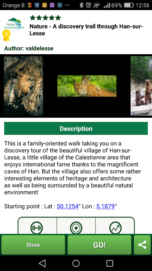
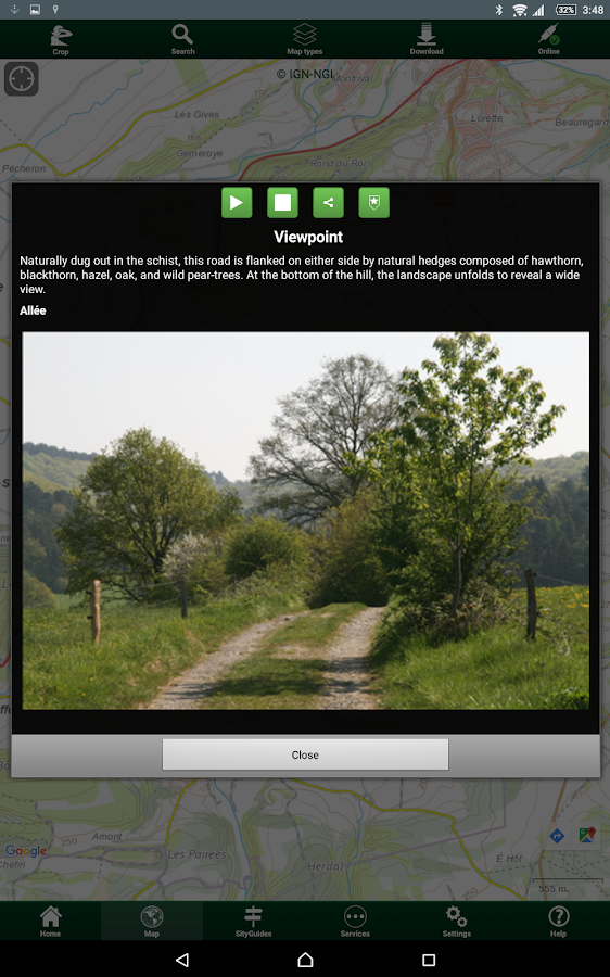
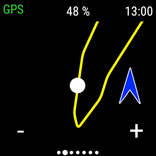
SityTrail is a GPS for all of your outdooractivities anywhere in Belgium.Here are its main functions:★ BELGIUM TOPOGRAPHIC MAPS IN YOUR POCKETAll the topographic maps you need to discover Belgium on foot,cycling, horse riding, or by car, motorbike or quad.Cycling network "node points" and GR paths are also available inoffline mode.Subscription charge: The application can be accessed forfree for a week’s trial. You may then take out a subscription for€14.99 per year, all-inclusive.★ MAPS AND YOUR WALKS AVAILABLE IN OFFLINE MODEThe download tool lets you get the most out of your maps and routeson the ground without any internet connection.There is an alarm when you stray from the route being followed. Nomore need to continuously check your smartphone, this alarm systemwill stop you getting lost or having to turn back onyourself.Automatic activation of points of interest and text to speechsynthesis.An elevation profile that enables the visualisation of inclines andof any difficulties along the route.★ RECORD YOUR ROUTES WITH PHOTOSRecord your walks in real time on the ground, and create points ofinterest with your own photos and commentary.Display showing distance covered, time taken, average speed, GPSaltitude, inclines (+/-), and many other useful indicators forwalkers and mountain bikers.Estimate of distance and time remaining based on your averagespeed.Elevation profile for the current recording.★ CREATE AND SHARE YOUR WALKSWith our online editor, create your own walking projects using aninternet navigator on your PC/MAC and then accessing them directlyfrom your mobile to experience them on the ground.Go further. Transform your favourite walks into real multimediaguides with text, photos, video links, and share them with theSityTrail community.Access too to thousands of walking circuits from other members andlet yourself be guided!★ TOURIST ATTRACTIONS AND WEATHER SERVICEGet plenty of localised tourist information: articlesWikipédia, accommodation, restaurants, and various servicessuch as chemists and banks.Save your favourite places so you can consult them during yourtrip.Check on the five-day weather forecast for any location on the mapto help you organise your stay.★ ADDITIONAL FUNCTIONSEasily create points of interest, such as the location of your car,your hotel, or a restaurant.In the event of any problems, the SOS function enables you to sendyour GPS coordinates to your contacts.Geocachers can use the compass to find their way to ageocache.★ ANDROID WEAR SMARTWATCH- Route and GPS position visualisation.- Indication of distance covered and remaining.- Arrow display indicating the direction to be taken.- Alarm when you stray from the route.We wish you lots of fun with SityTrail Belgium.Application Manual:http://www.sitytrail.com/lang-en/manuals_trail.htmlFor any questions or suggestions:http://www.sitytrail.com/lang-en/support_trail.html- - -Some functions need an internet connection.The prolonged use of GPS can reduce battery levels.

SityTrail Switzerland - hiking APK
SityTrail is a GPS for all of your outdooractivities anywhere in Switzerland.Here are its main functions:★ SWISSTOPO TOPOGRAPHIC MAPS IN YOUR POCKETAll the swisstopo topographic maps you need to discover Switzerlandon foot, cycling, horse riding, or by car, motorbike or quad.Subscription charge: The application can be accessed forfree for a week’s trial. You may then take out a subscription for55 CHF per year or 20 CHF per month, all-inclusive.★ MAPS AND YOUR WALKS AVAILABLE IN OFFLINE MODEThe download tool lets you get the most out of your maps and routeson the ground without any internet connection. *There is an alarm when you stray from the route being followed. Nomore need to continuously check your smartphone, this alarm systemwill stop you getting lost or having to turn back onyourself.Automatic activation of points of interest and text to speechsynthesis.An elevation profile that enables the visualisation of inclines andof any difficulties along the route.★ RECORD YOUR ROUTES WITH PHOTOSRecord your walks in real time on the ground, and create points ofinterest with your own photos and commentary.Display showing distance covered, time taken, average speed, GPSaltitude, inclines (+/-), and many other useful indicators forwalkers and mountain bikers.Estimate of distance and time remaining based on your averagespeed.Elevation profile for the current recording.★ CREATE AND SHARE YOUR WALKSWith our online editor, create your own walking projects using aninternet navigator on your PC/MAC and then accessing them directlyfrom your mobile to experience them on the ground.Go further. Transform your favourite walks into real multimediaguides with text, photos, video links, and share them with theSityTrail community.Access too to thousands of walking circuits from other members andlet yourself be guided!★ TOURIST ATTRACTIONS AND WEATHER SERVICEGet plenty of localised tourist information: articlesWikipédia, accommodation, restaurants, and various servicessuch as chemists and banks.Save your favourite places so you can consult them during yourtrip.Check on the five-day weather forecast for any location on the mapto help you organise your stay.★ ADDITIONAL FUNCTIONSEasily create points of interest, such as the location of your car,your hotel, or a restaurant.In the event of any problems, the SOS function enables you to sendyour GPS coordinates to your contacts.Geocachers can use the compass to find their way to ageocache.★ ANDROID WEAR SMARTWATCH- Route and GPS position visualisation.- Indication of distance covered and remaining.- Arrow display indicating the direction to be taken.- Alarm when you stray from the route.We wish you lots of fun with SityTrail Switzerland.Application Manual:http://www.sitytrail.com/lang-en/manuals_trail.htmlFor any questions or suggestions:http://www.sitytrail.com/lang-en/support_trail.html- - -Some functions need an internet connection.The prolonged use of GPS can reduce battery levels.* Download limit for maps stored simultaneously on your device foroffline use: 5000 km² for the one-year subscription (for example,the area of the Canton of Valais) or 2000 km² for the one-monthsubscription.Maps may not be downloaded for offline use during the one-weektrial period.

beCarto 14-18 1.0.5 APK
BeCarto14-18 is an app developed by the Belgian National GeographicInstitute (NGI) and the private company Geolives for thecommemoration of WW1. This App allows you to access spatial andhistorical information about the 1st World War in Belgium. Thespatial background of the app is CartoWeb.be, the NGI’s viewingservice equipped with a zooming tool that makes it possible to viewon screen the whole of Belgium or a very detailed picture of asmall area. We put above this topographic base the information fromthe map “14-18 The Great War from Liège to the Yser and the Somme”for the whole Belgian territory. You can locate museums, militarycemeteries, forts and trenches... that you still may visit today,but also have an overview of the large troops moves andconcentrations between 1914 and 1918. And that is where thehistorical information comes in. The app gives you access to twotimelines. The first one runs from 1914 till 1919 and gives youinformation about what happened on the Belgian territory duringthat time. The second one goes from 2014 to 2019 and gives youinformation about all events organized during that time as part ofthe commemoration. You also find a series of links to interestingwebsites, pictures and movies. Last but not least, beCarto14-18provides you with a lot of practical information such as museumopening times and addresses, place and time of events, etc. TheNational Geographic Institute of Belgium cooperated at the creationof this app with the Department of Defense and variousinstitutions, each of them possessing plenty of information aboutthe 1st World War according to their specific activity. Otherdatabases are expected to be made available via the app, like theone of the Institute for the Veterans, which will allow you tosearch information (like the day of death or the place where theywere buried) about the Belgian soldiers that were killed during the1st World War.

Oxygis 0.5.5.3r APK
Just as much as you will need smart, connected devices, you willneed smart and connected maps, to better manage the lifecycle ofyour assets. Today maps are timidly used as a geolocation display.Tomorrow you will use them as both a cockpit and control tower ofyour day-to-day operations. While we believe large enterprisesoftware solutions are necessary data gate-keepers, our mission isto complete your IT arsenal with a better interface that empowersoperational and decision-making users. Our vision involves a futurewhere your operational asset big data requires smart, connectedapplications to enable greater business value and reducedexploitation costs. Oxygis is : - Your go-to application for smartasset management - Your trusted advisor for integrated IOT-Big Dataprojects related to connected asset maintenance and smartpredictive maintenance projects Our technology partners include:LPWAN network services providers, industrial sensor suppliers,predictive analytics solutions, plant logistics optimization andimmersive 3D modelling solutions. Oxygis enables the swiftintegration of one or more of these solutions into the righttechnology architecture, the right business model, for yourbusiness needs. Our expertise lies in 10+ years of providing geomanagement solutions to fixed and critical asset owners,installation & maintenance subcontractors. Powered by Sityzen.

SityFit - free pedometer app 1.0.30 APK
SityFit is a free pedometer application which records the numberofsteps that you take every day. It works when your smartphone isinyour hand, your pocket or even in your backpack. The applicationiseasy to use, intuitive, and does not require an onlineaccount.Step values are displayed in tabs: today and yesterday, thelasttwo weeks and by month. Your results are displayed withbeautifulcharts and a monthly report in the form of acalendar.Notifications with motivating animations will help you tolive ahealthier life. SityFit will help you to keep fit and behealthier.Enjoy moving with SityFit! ------------------- To keepfit andhealthy, the World Health Organization (WHO) recommends10,000steps to be taken a day. But that is not so easy! An averagepersontakes between 4,000 and 6,000 steps a day and a sedentarypersontakes fewer than 3,000 steps. At first a reasonable goalwould beto increase the number of steps taken by 500 every week. Asecondgoal would be for you to try to reach 6000 steps a day onaveragefor a week, and then for a month. For your information, a30-minutewalk of moderate intensity represents around 3000 to 4000steps.Walking is therefore a very efficient physical activity forkeepingfit throughout the year. Don’t hesitate to discover ourSityTrailapplications, which give access to a catalogue withseveralthousands of trails. To practise a physical activity daily,hereare some simple ideas: • Take a break at the officeandstand up • Take the stairs • Get off the bus one stop earlier•Park a little further away • Take short walks • Play withyourchildren • Walk the dog • Do some gardening or jobs aroundthehouse • Do the housework listening to music and imitatingMrsDoubtfire For a more accurate step count you can invest inafitness band (€25 - €30).

SityZen 1.9.4 APK
SITYZEN... THE READY-2-GO MAP SOLUTION ! SityZen is a globalsolution designed to capture your data in the field and manage itreal-time in a powerful and user-friendly WebGIS application.SityZen has been designed for local authorities for use in variousdepartments. All based on the Cloud Computing technology. SityZenis available from any Internet browser and has also an Android andiOS application. MULTI-USERS SOLUTION Wherever they are differentactors of a subject have the last information encoded in thesolution. WHAT DATA ? SityZen is mainly adapted for geo-referenceddata encoding as for example : - road signs - addresses - buildings- etc. FEATURES - Login to a SityZen Server - Create and managepoints, lignes, polygons - Include and manage photos, videos andsounds for a point, line, polygon - Each point, line, polygon has adetailed descriptive sheet which can be adapted for each needs -Open Street Maps by default. Many other map types (IGN/PLI/etc.)are available when connected to a SityZen server (*) - SearchLocation - Many "layers" availables : "Trash", "Work" for example(*) - Capability to download maps for an offline use and spare yourData ! - The connection to a SityZen server is mandatory to use allfeatures of the application - Optimized for smartphones and tablets(*) These features are depending on the server you are connected.CLOUD-COMPUTING SOLUTION Interested by a SityZen server ? Get moreinformation on http://www.sityzen.net/

Similar Apps Show More...
SityTrail France - hiking GPS 12.7.0.2 APK
SityTrail is a GPS for all of your outdooractivities anywhere in France.Here are its main functions:★ IGN FRANCE TOPOGRAPHIC MAPS IN YOUR POCKETAll the topographic maps you need to discover France, Corsica andOverseas departments and territories on foot, cycling, horseriding, or by car, motorbike or quad.Subscription charge: The application can be accessed forfree for a week’s trial. You may then take out a subscription for€24.99 per year, all-inclusive.Tourism and discoveryDiscover the new 1:25 000 IGN map ideal to (re)discover an area onfoot, bicycle, horseback or car. The series includes coverage ofmainland France, Corsica and Overseas departments and territoriesrepresenting all relevant information for outdoor activities:roads, trails, streams, tourist sites, shelters, rest houses,buildings, religious buildings, ...The Grandes RandonnéesThe GR ®, maintained by the French Federation of Ramblers, are alsodisplayed: 60,000 km of hiking trails! Also shown on the maps arethe PR ® (petites randonnées) shorter walks for a day.★ MAPS AND YOUR WALKS AVAILABLE IN OFFLINE MODEThe download tool lets you get the most out of your maps and routeson the ground without any internet connection.There is an alarm when you stray from the route being followed. Nomore need to continuously check your smartphone, this alarm systemwill stop you getting lost or having to turn back onyourself.Automatic activation of points of interest and text to speechsynthesis.An elevation profile that enables the visualisation of inclines andof any difficulties along the route.★ RECORD YOUR ROUTES WITH PHOTOSRecord your walks in real time on the ground, and create points ofinterest with your own photos and commentary.Display showing distance covered, time taken, average speed, GPSaltitude, inclines (+/-), and many other useful indicators forwalkers and mountain bikers.Estimate of distance and time remaining based on your averagespeed.Elevation profile for the current recording.★ CREATE AND SHARE YOUR WALKSWith our online editor, create your own walking projects using aninternet navigator on your PC/MAC and then accessing them directlyfrom your mobile to experience them on the ground.Go further. Transform your favourite walks into real multimediaguides with text, photos, video links, and share them with theSityTrail community.Access too to thousands of walking circuits from other members andlet yourself be guided!★ TOURIST ATTRACTIONS AND WEATHER SERVICEGet plenty of localised tourist information: articlesWikipédia, accommodation, restaurants, and various servicessuch as chemists and banks.Save your favourite places so you can consult them during yourtrip.Check on the five-day weather forecast for any location on the mapto help you organise your stay.★ ADDITIONAL FUNCTIONSEasily create points of interest, such as the location of your car,your hotel, or a restaurant.In the event of any problems, the SOS function enables you to sendyour GPS coordinates to your contacts.Geocachers can use the compass to find their way to ageocache.★ ANDROID WEAR SMARTWATCH- Route and GPS position visualisation.- Indication of distance covered and remaining.- Arrow display indicating the direction to be taken.- Alarm when you stray from the route.We wish you lots of fun with SityTrail France.Application Manual:http://www.sitytrail.com/lang-en/manuals_trail.htmlFor any questions or suggestions:http://www.sitytrail.com/lang-en/support_trail.html- - -Some functions need an internet connection.The prolonged use of GPS can reduce battery levels.

Geo Tracker - GPS tracker 5.1.5.2972 APK
You can find answers to most common questionsin the FAQ section of my website:https://geo-tracker.org/faq/?lang=enIf you're looking for an excellent gps tracker, if you're a fan ofaction sports and long distance travel - this app is for you!Record tracks of your trips and share them with your friends!Geo Tracker can help:• making the reverse journey in an unfamiliar area without gettinglost
• tell your friends how to repeat your route
• use someone else's route that is stored in GPX or KML• mark important or interesting points of your trip.The application is able to record, even when switched off. Verylong tracks could be recorded without problems - you are limited bystorage memory only. Recorded tracks are saved in GPX or KMLformat, so they can be used in certain applications such as OziExplorer or Google Earth.When showing track on the map, the application keeps devicebacklight, which simplifies track navigation usage.Geo Tracker is based on public API of Yandex.Maps, so in trips overRussia and CIS countries you'll have the most detailed map of thearea.Application can calculate track statistics - boldly show off yourachievements to your friends :)Geo Tracker calculates:• Max & average speed on the track;• Time and average speed moving;• Max & min altitude, altitude difference;• Vertical distance, ascent & speed;• Min, max & average slope;There are also some fine charts of speed & elevation;If you have a proposal how to enchance the application or facedsome problem - please feel free to contact me:[email protected]. Thanks!Useful tips & tricks to solve common GPS issues with yoursmartphone:• If you start the tracking please wait with recording youractivity until the GPS signal is found.• Restart your smartphone and make sure that you have "clear view"of the sky before you start (no disturbing objects like highbuildings, forest, etc.).• The reception conditions are permanently changing because theygot influenced by the following factors: weather, season,positioning of satellites, areas with bad GPS coverage, highbuildings, forest, etc.).• Go to phone settings, choose "Location" and activate it.• Go to phone settings, choose "Date & time" and activate thefollowing options: "Automatic date & time" and "Automatic timezone". It may occur that it takes longer until the GPS signal isfound if your smartphone is set to the wrong time zone.• Deactivate the airplane mode in your phone settings.If none of these tips & tricks helped to solve your issues,deinstall the app and reinstall it again.Be aware that Google uses in their Google Maps app not only the GPSdata but also additional data of the current location fromsurrounding WLAN networks and/or mobile networks.

AlpineQuest GPS Hiking APK
AlpineQuest is the complete solution forall outdoor activities and sports, including hiking, running,trailing, hunting, sailing, geocaching, off-road navigation andmuch more.You can access and store locally a large range of on-linetopographic maps, which will remain available even while beingout of cell coverage. AlpineQuest also supports on-board filebased maps, like MemoryMap(c) maps.By using the GPS and the magnetic sensor of your device (withcompass display), getting lost is part of the past: you arelocalized in real-time on the map, which can also beoriented to match where you are looking at.Save and retrieve landmarks, share them with your friends.Track your path, get advanced statistics andinteractive graphics. You won't have anymore questions aboutwhat you can accomplish.By staying fully operational out of cell coverage (as often inmountain or abroad), AlpineQuest assists you in all your desires ofdeep wilderness exploring...Don't hesitate, try the free Lite version right now!PLEASE report suggestions and issues on our dedicated forumhttp://www.alpinequest.net/forum (no registration needed, allquestions answered) and not in comments.Key features are:★★ Maps ★★• Built-in online maps (with automatic local storage;road, topo and satellite maps included);• Built-in online layers (road names and hillsshading);• Get more online maps and layers in one click from the includedcommunity map list (Nokia maps, Yahoo! Maps, local topo maps,...);• Complete area storage of online maps for off-lineuse;• On-board offline maps support (visit our website to getthe free map creator MOBAC);• Memory-Map support (QuickChart .QCT maps only, .QC3 mapsnot compatible, test your maps using the free Lite versionfirst);• Multiple maps in layers display, with per-map opacitycontrol;• Advanced SD memory card Map Explorer and Scanner.★★ Landmarks ★★• Create, display, save, restore unlimited number of waypoints,routes, areas and tracks;• Import/export GPX files, Google Earth KML/KMZfiles, CSV/TSV files;• Support OziExplorer WPT and Geocaching LOCwaypoints;• Save and share online locations with other users using CommunityLandmarks;• Details, advanced statistics and interactive graphics on variousitems;• Time Controller to replay time-tagged tracks;• Routes, tracks and areas creator;• Advanced SD memory card Landmarks Explorer.★★ GPS Position / Orientation ★★• On-map geolocation using GPS or Network;• Map orientation, compass and target finder;• Built-in GPS/Barometric track recorder (long trackingcapable, running in a separate and light process);• Proximity alerts and leave path alerts;• Barometer support (for compatible devices).★★ And more: ★★• Metric, imperial and hybrid distance units;• GPS Latitude/Longitude and grid coordinate formats (UTM, MGRS,USNG, OSGB, Irish Grid, Swiss Grid, Lambert Grids, DFCI Grid, QTHMaidenhead Locator System, ...);• Ability to import hundreds of coordinate formats fromhttp://www.spatialreference.org;• On-map grids display;• Full screen map view;• Multi-touch zoom;• ...About the "Phone state and identity" Android permission: due to thebackward compatibility of AlpineQuest with Android 1.5, thispermission is automatically added by Google Play.

SityTrail Spain - hiking GPS APK
SityTrail is a GPS for all of your outdooractivities anywhere in Spain.Here are its main functions:★ SPAIN TOPOGRAPHIC MAPS IN YOUR POCKETAll the topographic maps you need to discover Spain on foot,cycling, horse riding, or by car, motorbike or quad.Subscription charge: The application can be accessed forfree for a week’s trial. You may then take out a subscription for€19.99 per year, all-inclusive.★ MAPS AND YOUR WALKS AVAILABLE IN OFFLINE MODEThe download tool lets you get the most out of your maps androutes on the ground without any internet connection.There is an alarm when you stray from the route being followed.No more need to continuously check your smartphone, this alarmsystem will stop you getting lost or having to turn back onyourself.Automatic activation of points of interest and text to speechsynthesis.An elevation profile that enables the visualisation of inclinesand of any difficulties along the route.★ RECORD YOUR ROUTES WITH PHOTOSRecord your walks in real time on the ground, and create pointsof interest with your own photos and commentary.Display showing distance covered, time taken, average speed, GPSaltitude, inclines (+/-), and many other useful indicators forwalkers and mountain bikers.Estimate of distance and time remaining based on your averagespeed.Elevation profile for the current recording.★ CREATE AND SHARE YOUR WALKSWith our online editor, create your own walking projects using aninternet navigator on your PC/MAC and then accessing them directlyfrom your mobile to experience them on the ground.Go further. Transform your favourite walks into real multimediaguides with text, photos, video links, and share them with theSityTrail community.Access too to thousands of walking circuits from other membersand let yourself be guided!★ TOURIST ATTRACTIONS AND WEATHER SERVICEGet plenty of localised tourist information: articlesWikipédia, accommodation, restaurants, and various servicessuch as chemists and banks.Save your favourite places so you can consult them during yourtrip.Check on the five-day weather forecast for any location on themap to help you organise your stay.★ ADDITIONAL FUNCTIONSEasily create points of interest, such as the location of yourcar, your hotel, or a restaurant.In the event of any problems, the SOS function enables you tosend your GPS coordinates to your contacts.Geocachers can use the compass to find their way to ageocache.★ ANDROID WEAR SMARTWATCH- Route and GPS position visualisation.- Indication of distance covered and remaining.- Arrow display indicating the direction to be taken.- Alarm when you stray from the route.We wish you lots of fun with SityTrail Spain.Application Manual:http://www.sitytrail.com/lang-en/manuals_trail.htmlFor any questions or suggestions:http://www.sitytrail.com/lang-en/support_trail.html- - -Some functions need an internet connection.The prolonged use of GPS can reduce battery levels.
 2.2.8b")
AlpineQuest GPS Hiking (Lite) 2.2.8b APK
AlpineQuest Lite is the free solution forall outdoor activities and sports, including hiking, running,trailing, hunting, sailing, geocaching, off-road navigation andmuch more.You can access and store locally a large range of on-linetopographic maps, which will remain available even while beingout of cell coverage. AlpineQuest also supports on-board filebased maps, like MemoryMap(c) maps.By using the GPS and the magnetic sensor of your device (withcompass display), getting lost is part of the past: you arelocalized in real-time on the map, which can also beoriented to match where you are looking at.By staying fully operational out of cell coverage (as often inmountain or abroad), AlpineQuest assists you in all your desires ofdeep wilderness exploring...Don't hesitate, use it right now for free!PLEASE report suggestions and issues on our dedicated forumhttp://www.alpinequest.net/forum (no registration needed, allquestions answered) and not in comments.Key features (for the full/paid version) are:★★ Maps ★★• Built-in online maps (with automatic local storage;road, topo and satellite maps included);• Built-in online layers (road names and hillsshading);• Get more online maps and layers in one click from the includedcommunity map list (Nokia maps, Yahoo! Maps, local topo maps,...);• Complete area storage of online maps for off-lineuse;• On-board offline maps support (visit our website to getthe free map creator MOBAC);• Memory-Map support (QuickChart .QCT maps only, .QC3 mapsnot compatible, test your maps using the free Lite versionfirst);• Multiple maps in layers display, with per-map opacitycontrol;• Advanced SD memory card Map Explorer and Scanner.★★ Landmarks ★★• Create, display, save, restore unlimited number of waypoints,routes, areas and tracks;• Import/export GPX files, Google Earth KML/KMZfiles, CSV/TSV files;• Support OziExplorer WPT and Geocaching LOCwaypoints;• Save and share online locations with other users using CommunityLandmarks;• Details, advanced statistics and interactive graphics on variousitems;• Time Controller to replay time-tagged tracks;• Routes, tracks and areas creator;• Advanced SD memory card Landmarks Explorer.★★ GPS Position / Orientation ★★• On-map geolocation using GPS or Network;• Map orientation, compass and target finder;• Built-in GPS/Barometric track recorder (long trackingcapable, running in a separate and light process);• Proximity alerts and leave path alerts;• Barometer support (for compatible devices).★★ And more: ★★• Metric, imperial and hybrid distance units;• GPS Latitude/Longitude and grid coordinate formats (UTM, MGRS,USNG, OSGB, Irish Grid, Swiss Grid, Lambert Grids, DFCI Grid, QTHMaidenhead Locator System, ...);• Ability to import hundreds of coordinate formats fromhttp://www.spatialreference.org;• On-map grids display;• Full screen map view;• Multi-touch zoom;• ...About the "Phone state and identity" Android permission: due to thebackward compatibility of AlpineQuest with Android 1.5, thispermission is automatically added by Google Play.


Travel & Local Top Show More...

Flightradar24 - Flight Tracker 6.7.1 APK
Turn your phone or tablet into anairtrafficradar and see planes around the world move in real-timeonadetailed map. Or point your Android device at a plane in theskytofind out where it’s going and more. Discover today whymillionsarealready using Flightradar24 - Flight Tracker.Features that have helped make Flightradar24 - FlightTrackerthe#1 selling app in 100+ countries and the #1 Travel appin140+countries (United States, France, United Kingdom, Germanyandmore)include:* Watch planes move in real-time on detailed map* Identify planes flying overhead by simply pointing yourdeviceatthe sky (the augmented reality view requiresrearcamera,accelerometer & magnetic sensor)* Experience what the pilot of a an aircraft sees in real-timeandin3D* Tap on a plane for comprehensive flight andaircraftinformationsuch as route, estimated time of arrival, actualtime ofdeparture,aircraft type, speed, altitude, andhigh-resolutionpicture* Easy to search for individual flights using flightnumber,airport,or airline* Easy to filter by airline, aircraft, altitude,speed,andmore* Easy to set bookmarks to enable quick navigation toareasofinterest* Turn the device into the arrivals and departures board ofanymajorairport and get real-time status updates for flightspluscurrentairport weather conditions (in-app purchase)* Realistic aircraft symbols (in-app purchase)* Set up custom alerts based on airline, aircraft type,flightnumberor registration (in-app purchase)HOW IT WORKSMost aircraft are equipped with so called ADS-Btranspondersthattransmit positional data. Flightradar24 has arapidlygrowingnetwork of several thousand ground stations aroundthe worldtoreceive this data that then shows up as aircraft movingon a mapinthe app. In an expanding number of regions Flightradar24,withthehelp of multilateration, is able to calculate thepositionsofaircraft that don’t have ADS-B transponders.Traditional radar data is also used in the app thanks toadirectfeed from the US Federal Aviation Administration (FAA).http://www.flightradar24.com/how-it-works***IMPORTANT NOTICES***Minimum required screen resolution is 320x480px.If you are only interested in tracking air traffic inaspecificregion, we suggest that you checkFlightradar24.comBEFOREpurchasing the app. Flightradar24 providesunrivaledpositionalaircraft data coverage around the world butthere areareas wherewe don’t have coverage.Overview of coverage as of January 2016:* Europe: close to 100%* North America: 100% of US and Canada via slightlydelayedradardata. Real-time coverage for most of US, Canada andMexicoforADS-B equipped aircraft* South America: Substantial coverage in mostcountriesincludingArgentina, Bolivia, Brazil, Chile, Colombia,EcuadorandVenezuela.* Asia: Substantial coverage in most major AsiancountriesincludingJapan, India, Indonesia, South Korea, Thailand,UAE,Malaysia,Taiwan and many other countries. Rapidlyexpandingcoverage inChina* Oceania: Nearly complete coverage in AustraliaandNewZealand* Africa: Substantial coverage in Africa with coverageexpandingallthe time.Find out how you can help:http://www.flightradar24.com/increase-coverageCoverage is subject to change at any time.HELP & SUPPORTforum.flightradar24.com/threads/89-Important-Read-this-before-you-ask-questionsflightradar24.com/contact-us.DISCLAIMERThe use of this app is strictly limited toentertainmentpurposes.This specifically excludes activities thatmight endangeryourselfor the lives of others. Under nocircumstances will thedeveloperof this app be held responsible forincidents resultingfrom theuse of the data or its interpretation orits use contraryto thisagreement. We reserve the right toanonymously track andreport auser's activity inside of app.

MOFA KSA 2.5.5 APK
يعد تطبيق وزارة الخارجيةالسعوديةللأجهزةالذكيةهو أحد قنوات الوصول لخدمات الوزارة والتي منخلالهيمكن تنفيذمجموعةمن الخدمات التي تستهدف شرائح مختلفة منالمستفيدين(أفراد،أعمال،وحكومة) كما يتم تحديث التطبيق بشكل دوريبمجموعة منالخدماتالجديدةوالتحسينات التي من شانها رفع مستوى الرضالدىالمستفيدين منخدماتالوزارة.تنفيذ وتطوير التطبيق:تم تطوير التطبيق من قبل الإدارةالعامةلتقنيةالمعلوماتوالاتصالاتالدعم الفني والاقتراحات:يرجى تعبئة الاستبيان الموجود ضمن مشاركاتإلكترونية-استبيانتطبيقالأجهزة الذكية أو مراسلتناعلىالبريدالإلكتروني[email protected]

MakeMyTrip Hotel Extranet 5.0.0 APK
Hoteliers, this one is foryou!MakeMyTrippresents the exclusive Hotel Extranet mobileappspecially designedto keep your hotel details up-to-date.With this app, you can:• Have access to day-wise / calendar view of your hotelrates&inventory• Update your hotel rates & inventory day-wise as well asforalonger period of time• Update ALL your tariffs’ inventory in just 2 steps• Track your important business metrics(likeCheck-InsToday/Tomorrow, Room Night Check-Ins in next 30 days,SoldOut innext 90 days etc.)• Keep a track of all your bookings & also takenecessaryactionslike Confirm a booking, Mark Check-In/No Show fora Pay AtHotelbooking• View complete details of a booking (including the voucher)• Call a Pay At Hotel customer with a single tap• Manage your Hotel Promotions in quick & easy waywithanability to create new promotions• Keep a track of your Payments• View help video tutorials to understand the utilityofourapp• Push Notifications to help you with Sold Out days &summaryofyour BookingsHotel Extranet will set you free from long chain mailsandphonecalls. No matter where you are, you can keep yourhoteldetailsfresh within a few easy steps.Also, there is lot more to come, which will make yourlifeeveneasier!

hottel - Hotel Booking 4.1.20 APK
Everyday hotels give us last-minutediscountsontheir available rooms.Best prices are guaranteed.Hotels are hand-picked to meet your expectation.10 seconds to book a roomPay less enjoy more.8:00 - 24:00 every night we are ready.Contact [email protected]