 2.2.8b")


Description
App Information AlpineQuest GPS Hiking (Lite)
- App NameAlpineQuest GPS Hiking (Lite)
- Package Namepsyberia.alpinequest.free
- UpdatedJune 8, 2017
- File SizeUndefined
- Requires AndroidAndroid Varies with device
- Version2.2.8b
- DeveloperPsyberia
- Installs500,000 - 1,000,000
- PriceFree
- CategoryTravel & Local
- Developer
- Google Play Link
AlpineQuest GPS Hiking (Lite) Version History
Select AlpineQuest GPS Hiking (Lite) Version :-
AlpineQuest GPS Hiking (Lite) 2.2.8b APK File
Publish Date: 2021 /4/11Requires Android: Android 3.0+ (Honeycomb, API: 11)File Size: 6.7 MBTested on: Android 10 (Quince Tart, API: 29)File Sha1: cd5127fb9b3c5561318f5e933b4efbef4fa123ce -
AlpineQuest GPS Hiking (Lite) 2.0.4 APK File
Publish Date: 2017 /5/8Requires Android: Android 3.0+ (Honeycomb, API: 11)File Size: 6.0 MBTested on: Android 6.0 (Marshmallow, API: 23)File Sha1: 120c142de6570403d6271ce7f2e868a38d217d56 -
AlpineQuest GPS Hiking (Lite) 2.0.3 APK File
Publish Date: 2017 /1/22Requires Android: Android 3.0+ (Honeycomb, API: 11)File Size: 5.9 MBTested on: Android 6.0 (Marshmallow, API: 23)File Sha1: a38ce6eabcfcd9898b8f1e6a3032493171374b9b -
AlpineQuest GPS Hiking (Lite) 2.0.2b APK File
Publish Date: 2016 /11/1Requires Android: Android 3.0+ (Honeycomb, API: 11)File Size: 5.9 MBTested on: Android 6.0 (Marshmallow, API: 23)File Sha1: 4969e7fe9a9ce715313820eaafea06771fe5948c -
AlpineQuest GPS Hiking (Lite) 2.0.2 APK File
Publish Date: 2016 /9/7Requires Android: Android 3.0+ (Honeycomb, API: 11)File Size: 5.8 MBTested on: Android 6.0 (Marshmallow, API: 23)File Sha1: 08a41a956c83e59be4af5b282988cbcb80a4fa6a -
AlpineQuest GPS Hiking (Lite) 2.0.1 APK File
Publish Date: 2016 /5/11Requires Android: Android 3.0+ (Honeycomb, API: 11)File Size: 5.4 MBTested on: Android 6.0 (Marshmallow, API: 23)File Sha1: 0afc4bed68b6003b981613fdc654e035410856ef -
AlpineQuest GPS Hiking (Lite) 2.0.0 APK File
Publish Date: 2016 /4/27Requires Android: Android 3.0+ (Honeycomb, API: 11)File Size: 5.4 MBTested on: Android 6.0 (Marshmallow, API: 23)File Sha1: c6db5135c2a796c66e111cf334e3dfe7c5982652 -
AlpineQuest GPS Hiking (Lite) 1.4.22 APK File
Publish Date: 2015 /11/23Requires Android: Android 1.5+ (Cupcake, API: 3)File Size: 4.8 MBTested on: Android 1.5 (Cupcake, API: 3)File Sha1: 4d9def9d00a41246dfc74d38b30928ae514f0640
Psyberia Show More...

All-In-One Offline Maps 3.6c APK
All-In-One OfflineMaps offers you to accessa wide range of maps for free.Bored to wait for maps to display? Once displayed, maps arestored and remain available, quickly, even with no networkaccess.• Want more than just roads on your maps? You will find whatyou need here;• Used to go to places with poor network coverage?Everything will stay available;• Used to go abroad? You won't be lost anymore;• Have a data allowance limit? It will reduce yourusage.★★ Maps ★★A lot of maps are available, including classical road maps,topographic maps, aerial (satellite) maps and various layers thatcan be added over any maps: OpenStreetMap (Roads, Topo), GoogleMaps, Bing Maps, USGS National Map (Hi-res topo, Aerial imagery),Worldwide Military Soviet topo maps, etc.• All maps can be stacked in layers, with precise opacitycontrol.• Select and store large areas in few clicks.• Stored space is clear and can be easily deleted.★★ Display, store and retrieve unlimited landmarks ★★You can add various items on the map such as waypoints, icons,routes, areas and tracks.You can easily manage them using the powerful SD-Card LandmarksExplorer.★★ On-map GPS Location & Orientation ★★Your real location and direction are clearly displayed on the map,which can be rotated to match your real orientation (depends ondevice capabilities).Easy turn on/off to save battery.And also:• Metric, imperial and hybrid distance units;• GPS Latitude/Longitude and grid coordinate formats (UTM, MGRS,USNG, OSGB Grid, Irish Grid, Swiss Grid, Lambert Grids, DFCI Grid,QTH Maidenhead Locator System, ...);• Ability to import hundreds of coordinate formats fromhttp://www.spatialreference.org;• On-map grids display;• Full screen map view;• Multi-touch zoom;• ...★★ Need more? ★★If you are a real adventurer, try AlpineQuest GPS Hiking,the complete outdoor solution based on All-In-One OfflineMaps,loaded with a powerful GPS Location Tracker and more:http://www.alpinequest.net/google-play

AlpineQuest GPS Hiking APK
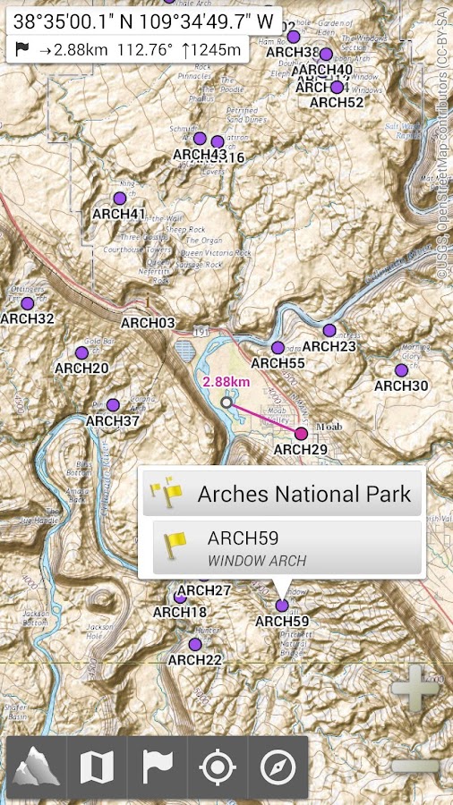
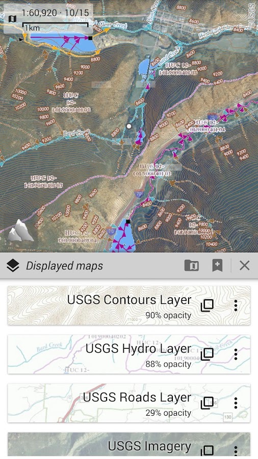
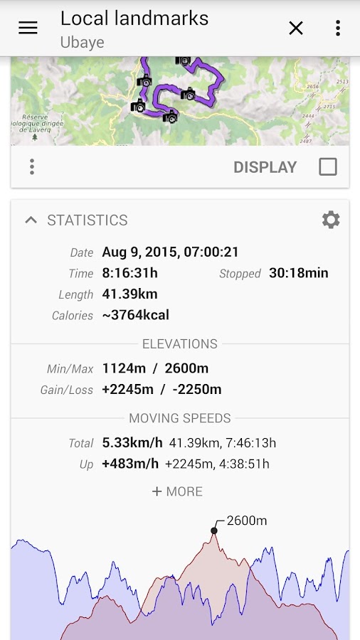
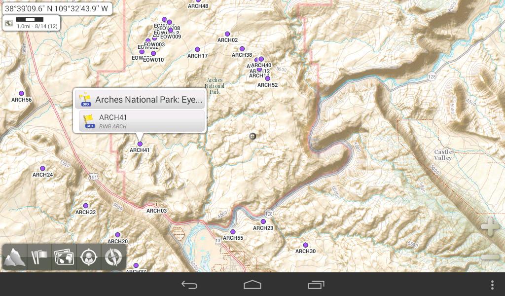
AlpineQuest is the complete solution forall outdoor activities and sports, including hiking, running,trailing, hunting, sailing, geocaching, off-road navigation andmuch more.You can access and store locally a large range of on-linetopographic maps, which will remain available even while beingout of cell coverage. AlpineQuest also supports on-board filebased maps, like MemoryMap(c) maps.By using the GPS and the magnetic sensor of your device (withcompass display), getting lost is part of the past: you arelocalized in real-time on the map, which can also beoriented to match where you are looking at.Save and retrieve landmarks, share them with your friends.Track your path, get advanced statistics andinteractive graphics. You won't have anymore questions aboutwhat you can accomplish.By staying fully operational out of cell coverage (as often inmountain or abroad), AlpineQuest assists you in all your desires ofdeep wilderness exploring...Don't hesitate, try the free Lite version right now!PLEASE report suggestions and issues on our dedicated forumhttp://www.alpinequest.net/forum (no registration needed, allquestions answered) and not in comments.Key features are:★★ Maps ★★• Built-in online maps (with automatic local storage;road, topo and satellite maps included);• Built-in online layers (road names and hillsshading);• Get more online maps and layers in one click from the includedcommunity map list (Nokia maps, Yahoo! Maps, local topo maps,...);• Complete area storage of online maps for off-lineuse;• On-board offline maps support (visit our website to getthe free map creator MOBAC);• Memory-Map support (QuickChart .QCT maps only, .QC3 mapsnot compatible, test your maps using the free Lite versionfirst);• Multiple maps in layers display, with per-map opacitycontrol;• Advanced SD memory card Map Explorer and Scanner.★★ Landmarks ★★• Create, display, save, restore unlimited number of waypoints,routes, areas and tracks;• Import/export GPX files, Google Earth KML/KMZfiles, CSV/TSV files;• Support OziExplorer WPT and Geocaching LOCwaypoints;• Save and share online locations with other users using CommunityLandmarks;• Details, advanced statistics and interactive graphics on variousitems;• Time Controller to replay time-tagged tracks;• Routes, tracks and areas creator;• Advanced SD memory card Landmarks Explorer.★★ GPS Position / Orientation ★★• On-map geolocation using GPS or Network;• Map orientation, compass and target finder;• Built-in GPS/Barometric track recorder (long trackingcapable, running in a separate and light process);• Proximity alerts and leave path alerts;• Barometer support (for compatible devices).★★ And more: ★★• Metric, imperial and hybrid distance units;• GPS Latitude/Longitude and grid coordinate formats (UTM, MGRS,USNG, OSGB, Irish Grid, Swiss Grid, Lambert Grids, DFCI Grid, QTHMaidenhead Locator System, ...);• Ability to import hundreds of coordinate formats fromhttp://www.spatialreference.org;• On-map grids display;• Full screen map view;• Multi-touch zoom;• ...About the "Phone state and identity" Android permission: due to thebackward compatibility of AlpineQuest with Android 1.5, thispermission is automatically added by Google Play.
 2.2.8b")
AlpineQuest GPS Hiking (Lite) 2.2.8b APK
AlpineQuest Lite is the free solution forall outdoor activities and sports, including hiking, running,trailing, hunting, sailing, geocaching, off-road navigation andmuch more.You can access and store locally a large range of on-linetopographic maps, which will remain available even while beingout of cell coverage. AlpineQuest also supports on-board filebased maps, like MemoryMap(c) maps.By using the GPS and the magnetic sensor of your device (withcompass display), getting lost is part of the past: you arelocalized in real-time on the map, which can also beoriented to match where you are looking at.By staying fully operational out of cell coverage (as often inmountain or abroad), AlpineQuest assists you in all your desires ofdeep wilderness exploring...Don't hesitate, use it right now for free!PLEASE report suggestions and issues on our dedicated forumhttp://www.alpinequest.net/forum (no registration needed, allquestions answered) and not in comments.Key features (for the full/paid version) are:★★ Maps ★★• Built-in online maps (with automatic local storage;road, topo and satellite maps included);• Built-in online layers (road names and hillsshading);• Get more online maps and layers in one click from the includedcommunity map list (Nokia maps, Yahoo! Maps, local topo maps,...);• Complete area storage of online maps for off-lineuse;• On-board offline maps support (visit our website to getthe free map creator MOBAC);• Memory-Map support (QuickChart .QCT maps only, .QC3 mapsnot compatible, test your maps using the free Lite versionfirst);• Multiple maps in layers display, with per-map opacitycontrol;• Advanced SD memory card Map Explorer and Scanner.★★ Landmarks ★★• Create, display, save, restore unlimited number of waypoints,routes, areas and tracks;• Import/export GPX files, Google Earth KML/KMZfiles, CSV/TSV files;• Support OziExplorer WPT and Geocaching LOCwaypoints;• Save and share online locations with other users using CommunityLandmarks;• Details, advanced statistics and interactive graphics on variousitems;• Time Controller to replay time-tagged tracks;• Routes, tracks and areas creator;• Advanced SD memory card Landmarks Explorer.★★ GPS Position / Orientation ★★• On-map geolocation using GPS or Network;• Map orientation, compass and target finder;• Built-in GPS/Barometric track recorder (long trackingcapable, running in a separate and light process);• Proximity alerts and leave path alerts;• Barometer support (for compatible devices).★★ And more: ★★• Metric, imperial and hybrid distance units;• GPS Latitude/Longitude and grid coordinate formats (UTM, MGRS,USNG, OSGB, Irish Grid, Swiss Grid, Lambert Grids, DFCI Grid, QTHMaidenhead Locator System, ...);• Ability to import hundreds of coordinate formats fromhttp://www.spatialreference.org;• On-map grids display;• Full screen map view;• Multi-touch zoom;• ...About the "Phone state and identity" Android permission: due to thebackward compatibility of AlpineQuest with Android 1.5, thispermission is automatically added by Google Play.

All-In-One Offline Maps + APK
All-In-One OfflineMaps+ offers you toaccess a wide range of maps.Bored to wait for maps to display? Once displayed, maps arestored and remain available, quickly, even with no networkaccess.• Want more than just roads on your maps? You will find whatyou need here;• Used to go to places with poor network coverage?Everything will stay available;• Used to go abroad? You won't be lost anymore;• Have a data allowance limit? It will reduce yourusage.This Plus version includes all features of the Standard versionwithout ads, and supports import of professional GPS and geographiclandmarks file formats (waypoints, routes, tracks, areas) like GPX,Google Earth KML/KMZ (map overlays not supported), OziExplorer WPT,CVS/TSV and Geocaching LOC★★ Maps ★★A lot of maps are available, including classical road maps,topographic maps, aerial (satellite) maps and various layers thatcan be added over any maps: OpenStreetMap (Roads, Topo), GoogleMaps, Bing Maps, USGS National Map (Hi-res topo, Aerial imagery),Worldwide Military Soviet topo maps, etc.• All maps can be stacked in layers, with precise opacitycontrol.• Select and store large areas in few clicks.• Stored space is clear and can be easily deleted.★★ Display, store and retrieve unlimited landmarks ★★You can add various items on the map such as waypoints, icons,routes, areas and tracks.You can easily manage them using the powerful SD-Card LandmarksExplorer.★★ On-map GPS Localization & Orientation ★★Your real location and direction are clearly displayed on the map,which can be rotated to match your real orientation (depends ondevice capabilities).Easy turn on/off to save battery.And also:• Metric, imperial and hybrid distance units;• GPS Latitude/Longitude and grid coordinate formats (UTM, MGRS,USNG, OSGB Grid, Irish Grid, Swiss Grid, Lambert Grids, DFCI Grid,QTH Maidenhead Locator System, ...);• Ability to import hundreds of coordinate formats fromhttp://www.spatialreference.org;• On-map grids display;• Full screen map view;• Multi-touch zoom;• ...★★ Need more? ★★If you are a real adventurer, try AlpineQuest GPS Hiking,the complete outdoor solution based on All-In-One OfflineMaps,loaded with a powerful GPS Location Tracker and more:http://www.alpinequest.net/google-play

SMS Locations Receiver 1.0 APK
This simple application allows you to displaylocations received by text messages (also called SMS) on a map inone click.Supported applications that can send and display locationsare:• All-In-One Offline Mapshttp://www.offline-maps.net/google-play• AlpineQuest GPS Hikinghttp://www.alpinequest.net/google-playThis application does not contain or display maps itself, it justopens and displays received locations in one of the previousapplications.
Similar Apps Show More...
AlpineQuest GPS Hiking APK
AlpineQuest is the complete solution forall outdoor activities and sports, including hiking, running,trailing, hunting, sailing, geocaching, off-road navigation andmuch more.You can access and store locally a large range of on-linetopographic maps, which will remain available even while beingout of cell coverage. AlpineQuest also supports on-board filebased maps, like MemoryMap(c) maps.By using the GPS and the magnetic sensor of your device (withcompass display), getting lost is part of the past: you arelocalized in real-time on the map, which can also beoriented to match where you are looking at.Save and retrieve landmarks, share them with your friends.Track your path, get advanced statistics andinteractive graphics. You won't have anymore questions aboutwhat you can accomplish.By staying fully operational out of cell coverage (as often inmountain or abroad), AlpineQuest assists you in all your desires ofdeep wilderness exploring...Don't hesitate, try the free Lite version right now!PLEASE report suggestions and issues on our dedicated forumhttp://www.alpinequest.net/forum (no registration needed, allquestions answered) and not in comments.Key features are:★★ Maps ★★• Built-in online maps (with automatic local storage;road, topo and satellite maps included);• Built-in online layers (road names and hillsshading);• Get more online maps and layers in one click from the includedcommunity map list (Nokia maps, Yahoo! Maps, local topo maps,...);• Complete area storage of online maps for off-lineuse;• On-board offline maps support (visit our website to getthe free map creator MOBAC);• Memory-Map support (QuickChart .QCT maps only, .QC3 mapsnot compatible, test your maps using the free Lite versionfirst);• Multiple maps in layers display, with per-map opacitycontrol;• Advanced SD memory card Map Explorer and Scanner.★★ Landmarks ★★• Create, display, save, restore unlimited number of waypoints,routes, areas and tracks;• Import/export GPX files, Google Earth KML/KMZfiles, CSV/TSV files;• Support OziExplorer WPT and Geocaching LOCwaypoints;• Save and share online locations with other users using CommunityLandmarks;• Details, advanced statistics and interactive graphics on variousitems;• Time Controller to replay time-tagged tracks;• Routes, tracks and areas creator;• Advanced SD memory card Landmarks Explorer.★★ GPS Position / Orientation ★★• On-map geolocation using GPS or Network;• Map orientation, compass and target finder;• Built-in GPS/Barometric track recorder (long trackingcapable, running in a separate and light process);• Proximity alerts and leave path alerts;• Barometer support (for compatible devices).★★ And more: ★★• Metric, imperial and hybrid distance units;• GPS Latitude/Longitude and grid coordinate formats (UTM, MGRS,USNG, OSGB, Irish Grid, Swiss Grid, Lambert Grids, DFCI Grid, QTHMaidenhead Locator System, ...);• Ability to import hundreds of coordinate formats fromhttp://www.spatialreference.org;• On-map grids display;• Full screen map view;• Multi-touch zoom;• ...About the "Phone state and identity" Android permission: due to thebackward compatibility of AlpineQuest with Android 1.5, thispermission is automatically added by Google Play.
")
GPS Status PRO - (legacy key) APK
NOTE: The main (free) app now supports in-apppayments to purchase a PRO license. Please purchase a licensefrom the side navigation menu of GPS Status & Toolbox. Toencourage the purchase the in-app license is 50% off compared tothis price. This app is left here only for users who havepreviously purchased the key app so they can still download it,when they need to reinstall the app.This is a plugin for 'GPS Status & Toolbox' that will removethe in-app advertisements from the program and add several PRO onlyfeatures. Please consider supporting the development.PRO features:- show/store/edit multiple waypoints and use them on the Radar fornavigation.- pressure, rotation, temperature, humidity values (if supported bythe device)- removed adsIf you do not have 'GPS Status & Toolbox' installed, visit the'More by MobiWIA' section and install it from there.If you like GPS Status & Toolbox, please leave a review hereand share your (hopefully) good experiences.Thank you for your support.NOTE: To avoid polluting your launcher with redundant icons, startGPS Status using the icon for the plugin (PRO). It will start GPSStatus and also will disable itself, so on next phone reboot theicon will disappear.-- MobiWIA - a cooperation with Andrs Studio --
Geo Tracker - GPS tracker 5.1.5.2972 APK
You can find answers to most common questionsin the FAQ section of my website:https://geo-tracker.org/faq/?lang=enIf you're looking for an excellent gps tracker, if you're a fan ofaction sports and long distance travel - this app is for you!Record tracks of your trips and share them with your friends!Geo Tracker can help:• making the reverse journey in an unfamiliar area without gettinglost
• tell your friends how to repeat your route
• use someone else's route that is stored in GPX or KML• mark important or interesting points of your trip.The application is able to record, even when switched off. Verylong tracks could be recorded without problems - you are limited bystorage memory only. Recorded tracks are saved in GPX or KMLformat, so they can be used in certain applications such as OziExplorer or Google Earth.When showing track on the map, the application keeps devicebacklight, which simplifies track navigation usage.Geo Tracker is based on public API of Yandex.Maps, so in trips overRussia and CIS countries you'll have the most detailed map of thearea.Application can calculate track statistics - boldly show off yourachievements to your friends :)Geo Tracker calculates:• Max & average speed on the track;• Time and average speed moving;• Max & min altitude, altitude difference;• Vertical distance, ascent & speed;• Min, max & average slope;There are also some fine charts of speed & elevation;If you have a proposal how to enchance the application or facedsome problem - please feel free to contact me:[email protected]. Thanks!Useful tips & tricks to solve common GPS issues with yoursmartphone:• If you start the tracking please wait with recording youractivity until the GPS signal is found.• Restart your smartphone and make sure that you have "clear view"of the sky before you start (no disturbing objects like highbuildings, forest, etc.).• The reception conditions are permanently changing because theygot influenced by the following factors: weather, season,positioning of satellites, areas with bad GPS coverage, highbuildings, forest, etc.).• Go to phone settings, choose "Location" and activate it.• Go to phone settings, choose "Date & time" and activate thefollowing options: "Automatic date & time" and "Automatic timezone". It may occur that it takes longer until the GPS signal isfound if your smartphone is set to the wrong time zone.• Deactivate the airplane mode in your phone settings.If none of these tips & tricks helped to solve your issues,deinstall the app and reinstall it again.Be aware that Google uses in their Google Maps app not only the GPSdata but also additional data of the current location fromsurrounding WLAN networks and/or mobile networks.

MAPS.ME – Map with Navigation and Directions v14.2.71484-googleRelease APK
Free, fast, detailed and entirely offline mapswith turn-by-turn navigation – trusted by over 90 milliontravelers worldwide.OFFLINE MAPSSave mobile data, no internet is required.FREE FOREVERAll maps inside and all features are free. Always were and alwayswill be.NAVIGATIONUse driving, walking and cycle navigation anywhere in theworld.INCREDIBLY DETAILEDDirections to points of interest (POI), hiking trails and placesmissing from other maps.UP-TO-DATEMaps are updated by millions of OpenStreetMap contributors daily.OSM is an open-source alternative to Google Maps, Mapquest andWaze.FAST AND RELIABLEOffline search, GPS navigation along with optimized maps toeffectively save memory space.BOOKMARKSSave locations you love and share them with your friends.AVAILABLE WORLDWIDEEssential for home and travel. Paris, France? Check. Amsterdam,Netherlands? Check. Barcelona, Spain? Check. New York, Chicago,Florida, Las Vegas, Nevada, Seattle, San Francisco, California,USA? Check! Rome, Italy? Check. London, UK? Check.TRAFFIC DATANew online city traffic maps. Check out updates on traffic info andfastest driving routes in 36 countries!AND MORE!– Search through different categories e.g. restaurants, cafes,tourist attractions, hotels, ATMs and public transport (metro,bus…)– Make hotel bookings via Booking.com directly from the app– Share your location via text message or social media– When cycling or walking, the app shows whether the way is uphillor downhillContinued use of GPS running in the background can dramaticallydecrease battery life.If you have any questions, visit our Help Center:support.maps.me.If you are unable to find the answer to your question, contact usat: [email protected] us on FB: http://www.facebook.com/mapswithme | Twitter:@MAPS_ME


All-In-One Offline Maps 3.6c APK
All-In-One OfflineMaps offers you to accessa wide range of maps for free.Bored to wait for maps to display? Once displayed, maps arestored and remain available, quickly, even with no networkaccess.• Want more than just roads on your maps? You will find whatyou need here;• Used to go to places with poor network coverage?Everything will stay available;• Used to go abroad? You won't be lost anymore;• Have a data allowance limit? It will reduce yourusage.★★ Maps ★★A lot of maps are available, including classical road maps,topographic maps, aerial (satellite) maps and various layers thatcan be added over any maps: OpenStreetMap (Roads, Topo), GoogleMaps, Bing Maps, USGS National Map (Hi-res topo, Aerial imagery),Worldwide Military Soviet topo maps, etc.• All maps can be stacked in layers, with precise opacitycontrol.• Select and store large areas in few clicks.• Stored space is clear and can be easily deleted.★★ Display, store and retrieve unlimited landmarks ★★You can add various items on the map such as waypoints, icons,routes, areas and tracks.You can easily manage them using the powerful SD-Card LandmarksExplorer.★★ On-map GPS Location & Orientation ★★Your real location and direction are clearly displayed on the map,which can be rotated to match your real orientation (depends ondevice capabilities).Easy turn on/off to save battery.And also:• Metric, imperial and hybrid distance units;• GPS Latitude/Longitude and grid coordinate formats (UTM, MGRS,USNG, OSGB Grid, Irish Grid, Swiss Grid, Lambert Grids, DFCI Grid,QTH Maidenhead Locator System, ...);• Ability to import hundreds of coordinate formats fromhttp://www.spatialreference.org;• On-map grids display;• Full screen map view;• Multi-touch zoom;• ...★★ Need more? ★★If you are a real adventurer, try AlpineQuest GPS Hiking,the complete outdoor solution based on All-In-One OfflineMaps,loaded with a powerful GPS Location Tracker and more:http://www.alpinequest.net/google-play


GPS Map 27.0.7 APK
GPS Map is a free, advertising supported app that allows you to doawesome things with a map powered by Google on Android devices. Fora price, you can get GPS Map Pro which is identical without theadvertising banner.Activities are organized into the following categories:* Search - Find new Placemarks by address, or coordinates.* My Location - Center or mark your place quickly, toggle Real/Mocklocation, Search nearby, and Share your location.* Layers - Allows you to toggle the visibility of My Location,Placemarks, Satellite, Traffic, Track, and Route layers.* Placemarks - View list, Center, Change location, use as Mocklocation, Navigate to, Route to, Search nearby, Street View, andShare* Routes - View list, Change color, Details, Hide, Show andShare* Tracks - View list, Start/Stop Recording, Change color, Graph,Tour on Google Earth, View at Human, Land, and Plane speed, andShare* Images - View list, set Default for Marker, Import as a Marker,Import location from Image* Markers - View list, Edit/Delete/Hide/Show groups of Placemarks,Markers created for each Import* Compass Mode - All visible layers rotate instead of My Locationarrow rotating towards north* Copyright - All the legal copyright and disclosure stuff* Data Management - Import/Export/Manage data* Help - A quick introduction, the FAQ, and links to other helpfulcontent about GPS Map* Preferences - Adjust update time, long press time, the visibilityof various items and featuresUse almost any image from your Camera, Gallery, or file browsingapp to create a Marker for a Placemark on the map. Imagescontaining location information can be imported as Placemarks withtheir image as the Marker on the map.GPS Map has the following features:* Easy to search for a location by address, placemark name, orlatitude, longitude.* Import/Export your Placemarks - GPSMap GPS, Garmin CSV, GeocodeGEO, Google Earth/Google Maps KML,GPS Exchange GPX filesand TomTomASCII* Imports the location and image from a photograph to create aPlacemark on the map with the Image as the Marker* Able to view Placemarks, Routes and Tracks with GoogleEarth* Able to be taken to Google Street View for a Placemark (ifavailable)* Able to use Placemarks to start a navigation app like GoogleNavigation* Export to Google Drive Fusion Tables with an active Gmailaccount* Creates Tours for Google Earth based upon your recorded TrackWorks best with:* Google Earth, Google Maps, Google Street View installed.GPS location service enabled.Visit https://sites.google.com/site/wrightkeith/gpsmap/ formore information.
Travel & Local Top Show More...

Flightradar24 - Flight Tracker 6.7.1 APK
Turn your phone or tablet into anairtrafficradar and see planes around the world move in real-timeonadetailed map. Or point your Android device at a plane in theskytofind out where it’s going and more. Discover today whymillionsarealready using Flightradar24 - Flight Tracker.Features that have helped make Flightradar24 - FlightTrackerthe#1 selling app in 100+ countries and the #1 Travel appin140+countries (United States, France, United Kingdom, Germanyandmore)include:* Watch planes move in real-time on detailed map* Identify planes flying overhead by simply pointing yourdeviceatthe sky (the augmented reality view requiresrearcamera,accelerometer & magnetic sensor)* Experience what the pilot of a an aircraft sees in real-timeandin3D* Tap on a plane for comprehensive flight andaircraftinformationsuch as route, estimated time of arrival, actualtime ofdeparture,aircraft type, speed, altitude, andhigh-resolutionpicture* Easy to search for individual flights using flightnumber,airport,or airline* Easy to filter by airline, aircraft, altitude,speed,andmore* Easy to set bookmarks to enable quick navigation toareasofinterest* Turn the device into the arrivals and departures board ofanymajorairport and get real-time status updates for flightspluscurrentairport weather conditions (in-app purchase)* Realistic aircraft symbols (in-app purchase)* Set up custom alerts based on airline, aircraft type,flightnumberor registration (in-app purchase)HOW IT WORKSMost aircraft are equipped with so called ADS-Btranspondersthattransmit positional data. Flightradar24 has arapidlygrowingnetwork of several thousand ground stations aroundthe worldtoreceive this data that then shows up as aircraft movingon a mapinthe app. In an expanding number of regions Flightradar24,withthehelp of multilateration, is able to calculate thepositionsofaircraft that don’t have ADS-B transponders.Traditional radar data is also used in the app thanks toadirectfeed from the US Federal Aviation Administration (FAA).http://www.flightradar24.com/how-it-works***IMPORTANT NOTICES***Minimum required screen resolution is 320x480px.If you are only interested in tracking air traffic inaspecificregion, we suggest that you checkFlightradar24.comBEFOREpurchasing the app. Flightradar24 providesunrivaledpositionalaircraft data coverage around the world butthere areareas wherewe don’t have coverage.Overview of coverage as of January 2016:* Europe: close to 100%* North America: 100% of US and Canada via slightlydelayedradardata. Real-time coverage for most of US, Canada andMexicoforADS-B equipped aircraft* South America: Substantial coverage in mostcountriesincludingArgentina, Bolivia, Brazil, Chile, Colombia,EcuadorandVenezuela.* Asia: Substantial coverage in most major AsiancountriesincludingJapan, India, Indonesia, South Korea, Thailand,UAE,Malaysia,Taiwan and many other countries. Rapidlyexpandingcoverage inChina* Oceania: Nearly complete coverage in AustraliaandNewZealand* Africa: Substantial coverage in Africa with coverageexpandingallthe time.Find out how you can help:http://www.flightradar24.com/increase-coverageCoverage is subject to change at any time.HELP & SUPPORTforum.flightradar24.com/threads/89-Important-Read-this-before-you-ask-questionsflightradar24.com/contact-us.DISCLAIMERThe use of this app is strictly limited toentertainmentpurposes.This specifically excludes activities thatmight endangeryourselfor the lives of others. Under nocircumstances will thedeveloperof this app be held responsible forincidents resultingfrom theuse of the data or its interpretation orits use contraryto thisagreement. We reserve the right toanonymously track andreport auser's activity inside of app.

MOFA KSA 2.5.5 APK
يعد تطبيق وزارة الخارجيةالسعوديةللأجهزةالذكيةهو أحد قنوات الوصول لخدمات الوزارة والتي منخلالهيمكن تنفيذمجموعةمن الخدمات التي تستهدف شرائح مختلفة منالمستفيدين(أفراد،أعمال،وحكومة) كما يتم تحديث التطبيق بشكل دوريبمجموعة منالخدماتالجديدةوالتحسينات التي من شانها رفع مستوى الرضالدىالمستفيدين منخدماتالوزارة.تنفيذ وتطوير التطبيق:تم تطوير التطبيق من قبل الإدارةالعامةلتقنيةالمعلوماتوالاتصالاتالدعم الفني والاقتراحات:يرجى تعبئة الاستبيان الموجود ضمن مشاركاتإلكترونية-استبيانتطبيقالأجهزة الذكية أو مراسلتناعلىالبريدالإلكتروني[email protected]

MakeMyTrip Hotel Extranet 5.0.0 APK
Hoteliers, this one is foryou!MakeMyTrippresents the exclusive Hotel Extranet mobileappspecially designedto keep your hotel details up-to-date.With this app, you can:• Have access to day-wise / calendar view of your hotelrates&inventory• Update your hotel rates & inventory day-wise as well asforalonger period of time• Update ALL your tariffs’ inventory in just 2 steps• Track your important business metrics(likeCheck-InsToday/Tomorrow, Room Night Check-Ins in next 30 days,SoldOut innext 90 days etc.)• Keep a track of all your bookings & also takenecessaryactionslike Confirm a booking, Mark Check-In/No Show fora Pay AtHotelbooking• View complete details of a booking (including the voucher)• Call a Pay At Hotel customer with a single tap• Manage your Hotel Promotions in quick & easy waywithanability to create new promotions• Keep a track of your Payments• View help video tutorials to understand the utilityofourapp• Push Notifications to help you with Sold Out days &summaryofyour BookingsHotel Extranet will set you free from long chain mailsandphonecalls. No matter where you are, you can keep yourhoteldetailsfresh within a few easy steps.Also, there is lot more to come, which will make yourlifeeveneasier!

hottel - Hotel Booking 4.1.20 APK
Everyday hotels give us last-minutediscountsontheir available rooms.Best prices are guaranteed.Hotels are hand-picked to meet your expectation.10 seconds to book a roomPay less enjoy more.8:00 - 24:00 every night we are ready.Contact [email protected]