
10.6.0 / May 4, 2023

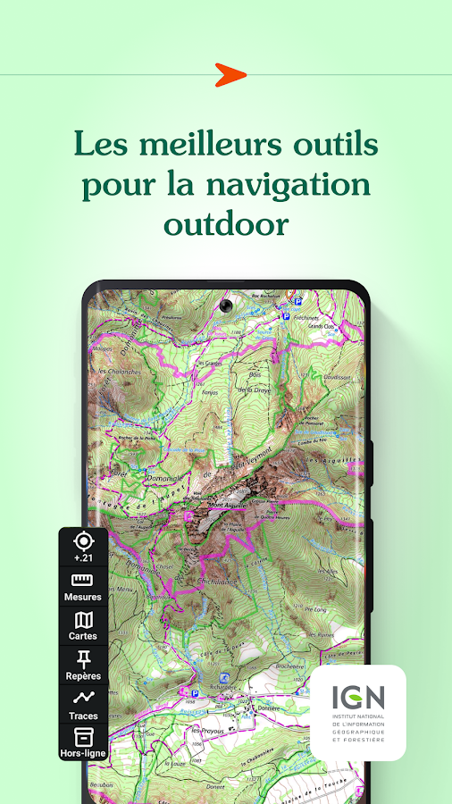
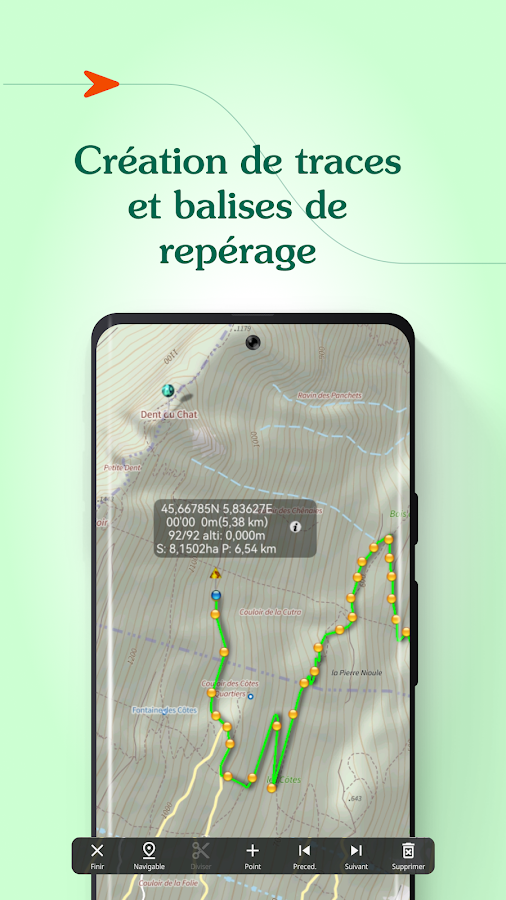
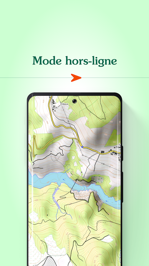
Description
App Information Iphigénie | The Hiking Map App
- App NameIphigénie | The Hiking Map App
- Package Namecom.iphigenie
- UpdatedMay 4, 2023
- File SizeUndefined
- Requires AndroidAndroid 5.0
- Version10.6.0
- DeveloperIphigénie
- Installs500K+
- PriceFree
- Categoryflag</i>Flag as inappropriate</a></div></section></div></div><div class="o45e4d"><c-wiz jsrenderer="Grlxwe" jsshadow jsdata="deferred-i18" data-p="%[email protected],true]" data-node-index="5;0" autoupdate jsmodel="hc6Ubd" c-wiz><section class="HcyOxe" jscontroller="NkbkFd"><header class=""><div class="VMq4uf" id="developer-contacts-heading"><div class="EaMWib"><h2 class="XfZNbf">Developer contact</h2></div><div jsaction="JIbuQc:Ptdedd"><button class="VfPpkd-Bz112c-LgbsSe yHy1rc eT1oJ mN1ivc VxpoF" jscontroller="soHxf" jsaction="click:cOuCgd; mousedown:UX7yZ; mouseup:lbsD7e; mouseenter:tfO1Yc; mouseleave:JywGue; touchstart:p6p2H; touchmove:FwuNnf; touchend:yfqBxc; touchcancel:JMtRjd; focus:AHmuwe; blur:O22p3e; contextmenu:mg9Pef;mlnRJb:fLiPzd;" data-disable-idom="true" aria-label="Expand" aria-controls="developer-contacts" aria-expanded="false"><div jsname="s3Eaab" class="VfPpkd-Bz112c-Jh9lGc"></div><div class="VfPpkd-Bz112c-J1Ukfc-LhBDec"></div><i class="google-material-icons VfPpkd-kBDsod W7A5Qb" aria-hidden="true">expand_more</i></button></div></div></header><div class="SfzRHd jqSImf" role="region" id="developer-contacts" aria-labelledby="developer-contacts-heading"><div class="vfQhrf BxIr0d"><div class="VfPpkd-WsjYwc VfPpkd-WsjYwc-OWXEXe-INsAgc KC1dQ Usd1Ac AaN0Dd VVmwY"><div class="VfPpkd-EScbFb-JIbuQc" jscontroller="tKHFxf" jsaction="click:cOuCgd; mousedown:UX7yZ; mouseup:lbsD7e; mouseenter:tfO1Yc; mouseleave:JywGue; touchstart:p6p2H; touchmove:FwuNnf; touchend:yfqBxc; touchcancel:JMtRjd; focus:AHmuwe; blur:O22p3e; contextmenu:mg9Pef;"><a class="Si6A0c RrSxVb" target="_blank" href="http://www.iphigen.ie"><i class="google-material-icons j25Vu" aria-hidden="true">language</i><div class="pZ8Djf"><div class="xFVDSb">Website</div><div class="pSEeg">http://www.iphigen.ie</div></div></a><div class="VfPpkd-FJ5hab"></div></div><span class="VfPpkd-BFbNVe-bF1uUb NZp2ef" aria-hidden="true">
- DeveloperChamonix, France
- Google Play Link
Iphigénie | The Hiking Map App Version History
Select Iphigénie | The Hiking Map App Version :-
Iphigénie | The Hiking Map App 10.3.8 APK File
Publish Date: 2022 /10/31Requires Android: Android 4.4+ (KitKat, API: 19)File Size: 19.3 MBTested on: Android 11 (Red Velvet Cake, API: 30)File Sha1: b2e4cb65412ae79d998bf56716f9ae73af4a8dfc -
Iphigénie | The Hiking Map App 7.2.5 APK File
Publish Date: 2017 /5/6Requires Android: Android 2.2+ (Froyo, API: 8)File Size: 9.5 MBTested on: Android 2.2 (Froyo, API: 8)File Sha1: ccac35f5bd2f31c2fa518efc568a5d6699199938 -
Iphigénie | The Hiking Map App 7.2.4 APK File
Publish Date: 2017 /5/26Requires Android: Android 2.2+ (Froyo, API: 8)File Size: 9.5 MBTested on: Android 2.2 (Froyo, API: 8)File Sha1: 21c4337db8553a7cdbca3abac843d898e08203e1 -
Iphigénie | The Hiking Map App 7.2.4 APK File
Publish Date: 2017 /5/9Requires Android: Android 2.2+ (Froyo, API: 8)File Size: 9.5 MBTested on: Android 2.2 (Froyo, API: 8)File Sha1: 21c4337db8553a7cdbca3abac843d898e08203e1 -
Iphigénie | The Hiking Map App 7.2.4 APK File
Publish Date: 2017 /3/5Requires Android: Android 2.2+ (Froyo, API: 8)File Size: 9.5 MBTested on: Android 2.2 (Froyo, API: 8)File Sha1: 21c4337db8553a7cdbca3abac843d898e08203e1 -
Iphigénie | The Hiking Map App 7.2.3 APK File
Publish Date: 2017 /1/9Requires Android: Android 2.2+ (Froyo, API: 8)File Size: 9.5 MBTested on: Android 2.2 (Froyo, API: 8)File Sha1: afea98a8384e999f56d01fde14c7d0b39e98db74 -
Iphigénie | The Hiking Map App 6.1.3 APK File
Publish Date: 2016 /4/8Requires Android: Android 2.2+ (Froyo, API: 8)File Size: 8.3 MBTested on: Android 2.2 (Froyo, API: 8)File Sha1: 2f0834a013811cf4f92d241428e97b7645544c7f -
Iphigénie | The Hiking Map App 6.1.2 APK File
Publish Date: 2016 /3/28Requires Android: Android 2.2+ (Froyo, API: 8)File Size: 8.3 MBTested on: Android 2.2 (Froyo, API: 8)File Sha1: 6be60a08e4a1744c7877d2fd3b851f74e667a25d -
Iphigénie | The Hiking Map App 6.1.1 APK File
Publish Date: 2016 /3/18Requires Android: Android 2.2+ (Froyo, API: 8)File Size: 8.3 MBTested on: Android 2.2 (Froyo, API: 8)File Sha1: 70d9e325eda87220797b3b11e5d4669e646c2582 -
Iphigénie | The Hiking Map App 6.0.5 APK File
Publish Date: 2016 /2/22Requires Android: Android 2.2+ (Froyo, API: 8)File Size: 8.2 MBTested on: Android 2.2 (Froyo, API: 8)File Sha1: cfd82c06e83658917eb3cbe7f9c615a812c9e55a -
Iphigénie | The Hiking Map App 6.0.3 APK File
Publish Date: 2016 /2/11Requires Android: Android 2.2+ (Froyo, API: 8)File Size: 7.9 MBTested on: Android 2.2 (Froyo, API: 8)File Sha1: 3d7c387d440e319b2afae3d9a75c81ff90657833

Similar Apps Show More...
 1.0.30")
IGN maps (E-walk plugin) 1.0.30 APK
E-WALK PLUGIN This app in an E-walk plugin (a plugin is an appthatadds features to another app). You need E-walk to use thisplugin:https://play.google.com/store/apps/details?id=com.at.ewalk.free.The plugin adds to E-walk the ability to use the French IGNmaps,and IGNrando'. WARNING: these features mostly cover Franceonly.IGN MAPS The IGN maps are highly detailed and cover thetotality offrench territory. Some maps are only available atcertain zoomlevels. They are the same as the ones used on theGéoportailwebsite (http://www.geoportail.gouv.fr). The IGN mapsplugin addsto E-walk 8 base maps : • ortho images: a highresolution satelliteimagery (zoom levels 2 - 19) • scan: a scan ofpaper IGN maps (zoomlevels 2 - 18) • scan express (classic): a scanof paper IGN mapsoften updated but with less details (zoom levels 6- 18) • scanexpress (standard): a scan of paper IGN maps oftenupdated but withless details, with another style (zoom levels 6 -18) • ICAO maps:International Civil Aviation Organisation maps(zoom levels 6 - 11)• administratives limits: administrativeslimits map (zoom levels 6- 10) • elevation map: digital terrainmodel (zoom levels 6 - 14) •army staff map (1820-1866): historicalmap from 18th century (zoomlevels 6 - 15) And 8 overlay maps: •cadastral parcels (black): mapof numerical cadastral information(zoom levels 2 - 20) • cadastralparcels (white): map of numericalcadastral information (zoomlevels 2 - 20) • cadastral parcels(orange): map of numericalcadastral information (zoom levels 2 -20) • administrative limits:map of administrative limits (zoomlevels 6 - 18) • buildings: mapof constructions (zoom levels 12 -18) • geographical names: mapshowing names of cities, towns, etc...(zoom levels 12 - 18) •Histolitt coastline: map showing the limitbetween land and marinearea (zoom levels 6 - 18) • hydrography: mapof lakes, reservoirs,rivers, creeks, etc... (zoom levels 6 - 18)LICENCES The pluginallows to see the maps through two licences:Discovery licence(free), and Adventure licence (5.99$USD / month or14.99$USD /year). The Discovery licence is limited by a monthlyquota sharedbetween all the users. Once the quota is exceeded, themaps can'tbe displayed until the next month. With the Adventurelicence, youcan also download the maps beforehand on your device,in order touse them without any internet access. IGNrando’IGNrando'(https://ignrando.fr) is a website provided by the IGN,allowingyou to visualize treks and points of interest among thetens ofthousands available. You can also add and share yours. Thosetreksand points of interest are mostly available in France only.WithE-walk, you can synchronize the treks and points of interestthatyou like on your device. Thereby, they will be availableanywhere,and you'll no longer need an internet access to see them.

Topo GPS France 7.2.0 APK
Makes from your phone or tablet a complete GPS device with thedetailed topographic map of France. Viewed maps will be stored onyour device so that Topo GPS can also be used without an internetconnection. Why should you buy an expensive GPS device if you caninstall Topo GPS? Topo GPS contains all functions of a regular GPSdevice for less money, has a much more detailed map, and is moreconvenient to operate. The accuracy of the position determinationis in favorable conditions about 5 m. The price of the detailedtopographic map is 0,99 € for four sections of 4 by 4 km. You getlifetime access to purchased sections including future map updates.You can easily select the sections you need on an overview map. Youget a discount if you buy a large section at once. Purchases aremade available on all devices that share the same Google Playaccount. Ideal for walking, hiking, cycling, mountainbiking,horse-riding, geocaching, trail running and other outdooractivities. Also suited for outdoor professionals. Map * Completetopographic map of France, scale 1:25,000 (SCAN25 from IGN), newestedition. * Very detailed maps, with buildings, cultivation, allroads including the smallest forest trails, contour lines, andcharacteristic elements in the landscape. * Future updates of themap are included for free. * The map can be zoomed and moved. * Allmaps of a certain region can be made offline accessible using themap download screen. * Percentage of map that is offline accessibleis indicated on the top left of the map. * Map tiles can be storedon external storage, like for example an SD-card. Intuitiveinterface * Clear menu with most important functions. * Differentdashboard panels with distance, time, speed, altitude andcoordinates. * Clear manual at www.topo-gps.com. Routes * Recordingof routes, with pause and restart possibility. * Planning of routesvia route points. * Importing routes in gpx and zipped gpx format.* Editing routes. * Sharing routes. * Free access to routecollection Topo GPS. * Searching routes with filters. * Routes canbe organized into folders. * Maps of a route can be made offlineaccessible. Waypoints * Adding waypoints by pressing on map. *Adding waypoints through address or coordinates. * Supportedcoordinate systems: WGS84 decimal, WGS84 degree minutes (seconds),UTM, MGRS and Lambert93. * Importing waypoints in gpx and zippedgpx format. * Sharing waypoints. * Editing waypoints. * Photos canbe added to waypoints. * Searching waypoints with filters. *Waypoints can be organized into folders. Your location * Locationand movement direction indicated by arrowed marker. * Displayablein WGS84 decimal, WGS84 degree minutes (seconds), UTM, MGRS andLambert 93 coordinates. * Sharing and saving as waypoint. In apppurchases * Topographic maps of Belgium, Denmark, Finland, France,Germany, Great Britain, Netherlands, Norway, New Zealand andSweden. * OpenStreetMap world map. If you are recording a route,the GPS will run in the background. Continued use of GPS running inthe background can dramatically decrease battery life. Rdzl, thecompany behind Topo GPS, does not obtain in any way the location ofthe user of Topo GPS. Rdzl does not obtain your routes andwaypoints, unless you share a route with Topo GPS. Rdzl does notregister which map tiles you have downloaded. We sell our product,not our user data.


SityTrail France - hiking GPS 12.7.0.2 APK
SityTrail is a GPS for all of your outdooractivities anywhere in France.Here are its main functions:★ IGN FRANCE TOPOGRAPHIC MAPS IN YOUR POCKETAll the topographic maps you need to discover France, Corsica andOverseas departments and territories on foot, cycling, horseriding, or by car, motorbike or quad.Subscription charge: The application can be accessed forfree for a week’s trial. You may then take out a subscription for€24.99 per year, all-inclusive.Tourism and discoveryDiscover the new 1:25 000 IGN map ideal to (re)discover an area onfoot, bicycle, horseback or car. The series includes coverage ofmainland France, Corsica and Overseas departments and territoriesrepresenting all relevant information for outdoor activities:roads, trails, streams, tourist sites, shelters, rest houses,buildings, religious buildings, ...The Grandes RandonnéesThe GR ®, maintained by the French Federation of Ramblers, are alsodisplayed: 60,000 km of hiking trails! Also shown on the maps arethe PR ® (petites randonnées) shorter walks for a day.★ MAPS AND YOUR WALKS AVAILABLE IN OFFLINE MODEThe download tool lets you get the most out of your maps and routeson the ground without any internet connection.There is an alarm when you stray from the route being followed. Nomore need to continuously check your smartphone, this alarm systemwill stop you getting lost or having to turn back onyourself.Automatic activation of points of interest and text to speechsynthesis.An elevation profile that enables the visualisation of inclines andof any difficulties along the route.★ RECORD YOUR ROUTES WITH PHOTOSRecord your walks in real time on the ground, and create points ofinterest with your own photos and commentary.Display showing distance covered, time taken, average speed, GPSaltitude, inclines (+/-), and many other useful indicators forwalkers and mountain bikers.Estimate of distance and time remaining based on your averagespeed.Elevation profile for the current recording.★ CREATE AND SHARE YOUR WALKSWith our online editor, create your own walking projects using aninternet navigator on your PC/MAC and then accessing them directlyfrom your mobile to experience them on the ground.Go further. Transform your favourite walks into real multimediaguides with text, photos, video links, and share them with theSityTrail community.Access too to thousands of walking circuits from other members andlet yourself be guided!★ TOURIST ATTRACTIONS AND WEATHER SERVICEGet plenty of localised tourist information: articlesWikipédia, accommodation, restaurants, and various servicessuch as chemists and banks.Save your favourite places so you can consult them during yourtrip.Check on the five-day weather forecast for any location on the mapto help you organise your stay.★ ADDITIONAL FUNCTIONSEasily create points of interest, such as the location of your car,your hotel, or a restaurant.In the event of any problems, the SOS function enables you to sendyour GPS coordinates to your contacts.Geocachers can use the compass to find their way to ageocache.★ ANDROID WEAR SMARTWATCH- Route and GPS position visualisation.- Indication of distance covered and remaining.- Arrow display indicating the direction to be taken.- Alarm when you stray from the route.We wish you lots of fun with SityTrail France.Application Manual:http://www.sitytrail.com/lang-en/manuals_trail.htmlFor any questions or suggestions:http://www.sitytrail.com/lang-en/support_trail.html- - -Some functions need an internet connection.The prolonged use of GPS can reduce battery levels.


MyTrails 2.1.11 APK
No ads even in the free version! Perfect for hiking,riding,cycling, running, skiing or orienteering Premium topo mapsUsein-app purchases to subscribe to high-quality,special-purposemaps. Flexible offline mode and competitive pricing.• OS OpenData(GB) • IGN TOP25, TOP50, Cadastre, Satellite andLittoral (marinemaps) (FR) http://www.frogsparks.com/mytrails/ign/Full-screentrail map oriented with the built-in compass and GPSKnow exactlywhich direction you are going. Uncluttered map area,withunobtrusive controls and a traditional scale with trackdurationand distance. Hardware-accelerated map drawing allowssmooth andsnappy display even with tens of thousands of trackpoints. Stats40+ stats to choose from! Display them on a dedicatedscreen(including stats for multiple tracks at once), on theHUDoverlaying the map or even on Android Wear. Graphs Freelydefineaxes (over 30 combinations) to visualize your tracks,includingelevation profiles, speed vs. time, etc. Free online mapsPick frommany built-in online map sources (OpenStreetMap, Yahoo,Bing,Google and many other global and local providers). Add moremapsources using the configurable map sources (URL or WMS).Onlypremium maps are guaranteed: we may be forced to remove accesstoany of the free maps if requested by the rights-holders; thisisregardless of whether you are using the Pro or Freeversion.Offline maps Save battery and data charges. The mapdisplaysinstantaneously. No need to use desktop-based tools tocreateoffline maps, you can do it in MyTrails, in the background.RecordGPS tracks Visualize your track at any time and analyse yourcourseduring or after the outdoor activity. Display multiplecolorizedGPS tracks at once (Pro) Visualize your previous outingsand thoseuploaded to GPS community sites, so that you always pick agreattrail. Visualize the key indicators of the track (altitude,speed,rate of ascent, slope, GPS accuracy, etc.) right on the mapwith adetailed legend. Waypoints Manually add waypoints toindicatememorable spots or upcoming turns. Waypoints areautomaticallygenerated when getting directions or when you take abreak. Shareand archive tracks (Pro) Share your tracks on MyTrails, GPSies,UtagawaVTT and la-trace.com. Download tracks sharedby other usersin your vicinity. Gestures Easily switch betweenactive maps byswiping three fingers left to right in the map view.Pull down theHUD with information on your speed and altitude byswiping threefingers down your screen. Full tablet support Planyour outing on alarge-screen tablet, go out and have fun, and whenyou're back,view the track in full glory. Use Dropbox to seamlesslysynchronizebetween devices. FAQ: http://www.frogsparks.com/faq/Permissions:please see the FAQ

