
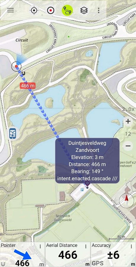
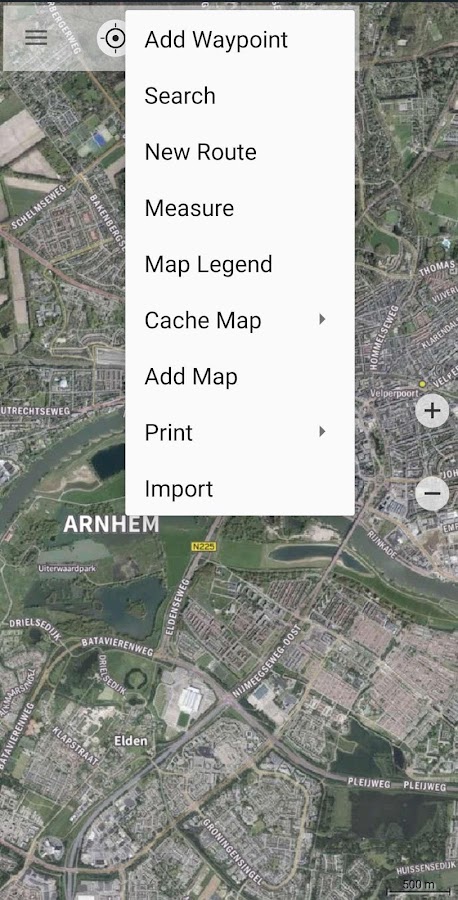
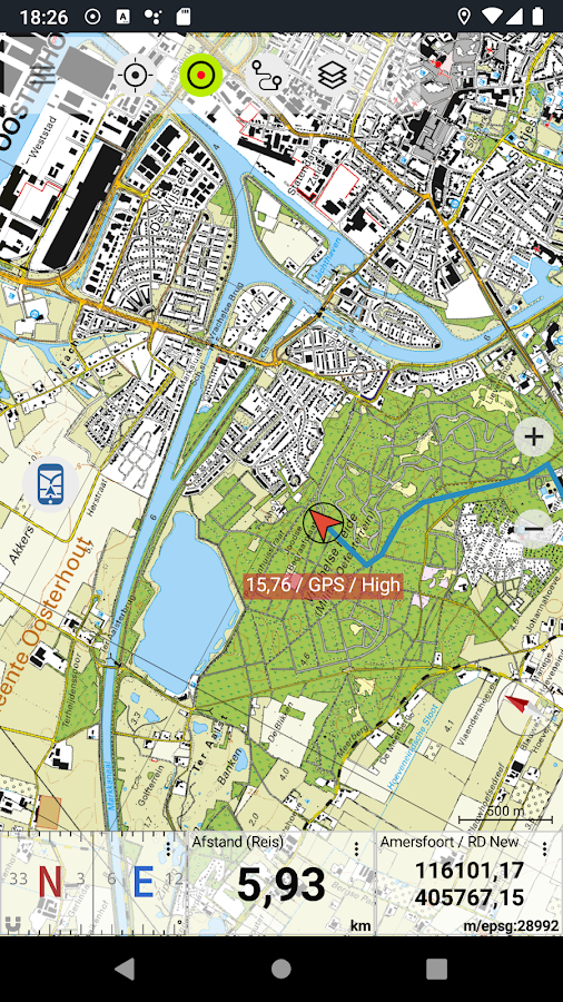

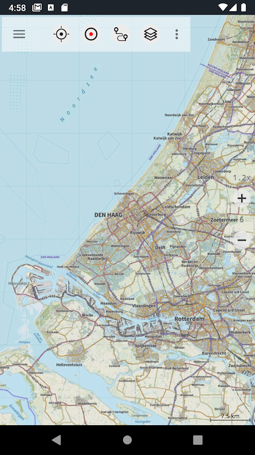
Description
App Information Netherland Topo Maps
- App NameNetherland Topo Maps
- Package Namecom.atlogis.netherland
- UpdatedMar 16, 2023
- File SizeUndefined
- Requires AndroidAndroid 5.0
- Version7.0.0
- DeveloperATLOGIS Geoinformatics GmbH & Co. KG
- Installs-
- PriceFree
- Category
- DeveloperUnter den Ulmen 8 33330 Gütersloh Germany
- Google Play Link
ATLOGIS Geoinformatics GmbH & Co. KG Show More...


Similar Apps Show More...


Topo GPS Spain 6.2.0 APK
Makes from your phone or tablet a complete GPS device with thedetailed topographic map of Spain. Viewed maps will be stored onyour device so that Topo GPS can also be used without an internetconnection. Why should you buy an expensive GPS device if you caninstall Topo GPS on your phone or tablet for only 3,99 €? Topo GPScontains all functions of a regular GPS device for less money, hasa much more detailed map, and is more convenient to operate. Theaccuracy of the position determination is in favorable conditionsabout 5 m. Ideal for walking, hiking, cycling, mountainbiking,horse-riding, geocaching, trail running and other outdooractivities. Also suited for outdoor professionals. Map * Completetopographic map of Spain , newest edition. * Very detailed maps,with buildings, cultivation, all roads including the smallestforest trails, contour lines, and characteristic elements in thelandscape. * Future updates of the map are included for free. * Themap can be zoomed and moved. * All maps of a certain region can bemade offline accessible using the map download screen. * Percentageof map that is offline accessible is indicated on the top left ofthe map. * Map tiles can be stored on external storage, like forexample an SD-card. Intuitive interface * Clear menu with mostimportant functions. * Different dashboard panels with distance,time, speed, altitude and coordinates. * Clear manual atwww.topo-gps.com. Routes * Recording of routes, with pause andrestart possibility. * Planning of routes via route points. *Importing routes in gpx and zipped gpx format. * Editing routes. *Sharing routes. * Free access to route collection Topo GPS. *Searching routes with filters. * Routes can be organized intofolders. * Maps of a route can be made offline accessible.Waypoints * Adding waypoints by pressing on map. * Adding waypointsthrough address or coordinates. * Supported coordinate systems:WGS84 decimal, WGS84 degree minutes (seconds), UTM and MGRS. *Importing waypoints in gpx and zipped gpx format. * Sharingwaypoints. * Editing waypoints. * Photos can be added to waypoints.* Searching waypoints with filters. * Waypoints can be organizedinto folders. Your location * Location and movement directionindicated by arrowed marker. * Displayable in WGS84 decimal, WGS84degree minutes (seconds), UTM and MGRS coordinates. * Sharing andsaving as waypoint. In app purchases * Topographic maps of Belgium,Denmark, Finland, France, Germany, Great Britain, Netherlands,Norway, New Zealand and Sweden. * OpenStreetMap world map. If youare recording a route, the GPS will run in the background.Continued use of GPS running in the background can dramaticallydecrease battery life. Rdzl, the company behind Topo GPS, does notobtain in any way the location of the user of Topo GPS. Rdzl doesnot obtain your routes and waypoints, unless you share a route withTopo GPS. Rdzl does not register which map tiles you havedownloaded. We sell our product, not our user data.


MyTrails 2.1.11 APK
No ads even in the free version! Perfect for hiking,riding,cycling, running, skiing or orienteering Premium topo mapsUsein-app purchases to subscribe to high-quality,special-purposemaps. Flexible offline mode and competitive pricing.• OS OpenData(GB) • IGN TOP25, TOP50, Cadastre, Satellite andLittoral (marinemaps) (FR) http://www.frogsparks.com/mytrails/ign/Full-screentrail map oriented with the built-in compass and GPSKnow exactlywhich direction you are going. Uncluttered map area,withunobtrusive controls and a traditional scale with trackdurationand distance. Hardware-accelerated map drawing allowssmooth andsnappy display even with tens of thousands of trackpoints. Stats40+ stats to choose from! Display them on a dedicatedscreen(including stats for multiple tracks at once), on theHUDoverlaying the map or even on Android Wear. Graphs Freelydefineaxes (over 30 combinations) to visualize your tracks,includingelevation profiles, speed vs. time, etc. Free online mapsPick frommany built-in online map sources (OpenStreetMap, Yahoo,Bing,Google and many other global and local providers). Add moremapsources using the configurable map sources (URL or WMS).Onlypremium maps are guaranteed: we may be forced to remove accesstoany of the free maps if requested by the rights-holders; thisisregardless of whether you are using the Pro or Freeversion.Offline maps Save battery and data charges. The mapdisplaysinstantaneously. No need to use desktop-based tools tocreateoffline maps, you can do it in MyTrails, in the background.RecordGPS tracks Visualize your track at any time and analyse yourcourseduring or after the outdoor activity. Display multiplecolorizedGPS tracks at once (Pro) Visualize your previous outingsand thoseuploaded to GPS community sites, so that you always pick agreattrail. Visualize the key indicators of the track (altitude,speed,rate of ascent, slope, GPS accuracy, etc.) right on the mapwith adetailed legend. Waypoints Manually add waypoints toindicatememorable spots or upcoming turns. Waypoints areautomaticallygenerated when getting directions or when you take abreak. Shareand archive tracks (Pro) Share your tracks on MyTrails, GPSies,UtagawaVTT and la-trace.com. Download tracks sharedby other usersin your vicinity. Gestures Easily switch betweenactive maps byswiping three fingers left to right in the map view.Pull down theHUD with information on your speed and altitude byswiping threefingers down your screen. Full tablet support Planyour outing on alarge-screen tablet, go out and have fun, and whenyou're back,view the track in full glory. Use Dropbox to seamlesslysynchronizebetween devices. FAQ: http://www.frogsparks.com/faq/Permissions:please see the FAQ


