


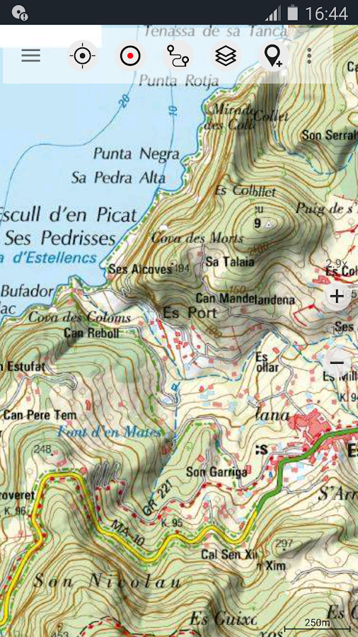
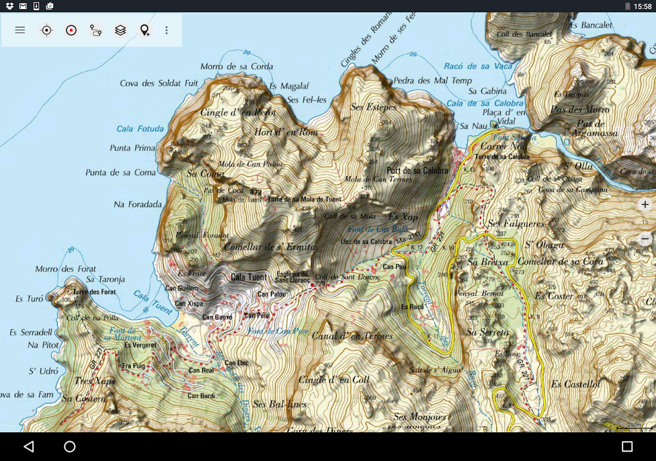


Description
App Information Mallorca Topo Maps
- App NameMallorca Topo Maps
- Package Namecom.atlogis.mallorca
- UpdatedOct 13, 2023
- File SizeUndefined
- Requires AndroidAndroid 5.0
- Version7.1.0
- DeveloperATLOGIS Geoinformatics GmbH & Co. KG
- Installs-
- PriceFree
- Category
- DeveloperUnter den Ulmen 8 33330 Gütersloh Germany
- Google Play Link
Mallorca Topo Maps Version History
Select Mallorca Topo Maps Version :-
Mallorca Topo Maps 6.8.0 APK File
Publish Date: 2022 /9/6Requires Android: Android 5.0+ (Lollipop, API: 21)File Size: 11.3 MBTested on: Android 12 (Snow Cone, API: 31)File Sha1: 969bf95fa6690606aa5127bca9db0f9e90dc8df8
ATLOGIS Geoinformatics GmbH & Co. KG Show More...


Similar Apps Show More...


Topo GPS Spain 6.2.0 APK
Makes from your phone or tablet a complete GPS device with thedetailed topographic map of Spain. Viewed maps will be stored onyour device so that Topo GPS can also be used without an internetconnection. Why should you buy an expensive GPS device if you caninstall Topo GPS on your phone or tablet for only 3,99 €? Topo GPScontains all functions of a regular GPS device for less money, hasa much more detailed map, and is more convenient to operate. Theaccuracy of the position determination is in favorable conditionsabout 5 m. Ideal for walking, hiking, cycling, mountainbiking,horse-riding, geocaching, trail running and other outdooractivities. Also suited for outdoor professionals. Map * Completetopographic map of Spain , newest edition. * Very detailed maps,with buildings, cultivation, all roads including the smallestforest trails, contour lines, and characteristic elements in thelandscape. * Future updates of the map are included for free. * Themap can be zoomed and moved. * All maps of a certain region can bemade offline accessible using the map download screen. * Percentageof map that is offline accessible is indicated on the top left ofthe map. * Map tiles can be stored on external storage, like forexample an SD-card. Intuitive interface * Clear menu with mostimportant functions. * Different dashboard panels with distance,time, speed, altitude and coordinates. * Clear manual atwww.topo-gps.com. Routes * Recording of routes, with pause andrestart possibility. * Planning of routes via route points. *Importing routes in gpx and zipped gpx format. * Editing routes. *Sharing routes. * Free access to route collection Topo GPS. *Searching routes with filters. * Routes can be organized intofolders. * Maps of a route can be made offline accessible.Waypoints * Adding waypoints by pressing on map. * Adding waypointsthrough address or coordinates. * Supported coordinate systems:WGS84 decimal, WGS84 degree minutes (seconds), UTM and MGRS. *Importing waypoints in gpx and zipped gpx format. * Sharingwaypoints. * Editing waypoints. * Photos can be added to waypoints.* Searching waypoints with filters. * Waypoints can be organizedinto folders. Your location * Location and movement directionindicated by arrowed marker. * Displayable in WGS84 decimal, WGS84degree minutes (seconds), UTM and MGRS coordinates. * Sharing andsaving as waypoint. In app purchases * Topographic maps of Belgium,Denmark, Finland, France, Germany, Great Britain, Netherlands,Norway, New Zealand and Sweden. * OpenStreetMap world map. If youare recording a route, the GPS will run in the background.Continued use of GPS running in the background can dramaticallydecrease battery life. Rdzl, the company behind Topo GPS, does notobtain in any way the location of the user of Topo GPS. Rdzl doesnot obtain your routes and waypoints, unless you share a route withTopo GPS. Rdzl does not register which map tiles you havedownloaded. We sell our product, not our user data.


BackCountry Nav Topo Maps GPS APK
Use your Android as an offroad topo mappingGPS with the bestselling outdoor navigation app for Android! Trythis DEMO to see if it is right for you, then upgrade to the paidversion.Use offline topo maps and GPS on hike trails without cell service!The GPS in your Android phone can get its position from satellites,and you don’t have to rely on your data plan to get maps. Have morefun and safe GPS adventures in the backcountry.Preload FREE offline topo maps, aerial photos, and road maps onyour storage memory, so they are ready when you need them.Add custom GPS waypoints in longitude and latitude, UTM or MGRSgrid reference. Import GPS waypoints from GPX files. Choose iconsfor waypoints much like in MapSource. (This app uses the WGS84datum, NAD27 is available in settings).Use GPS for hunting a waypoint or geocache, for recording tracksand GPS waypoints on your trip, all the while tracking your queston topographic maps.About topo (topographic) maps: Topo maps show terrain through colorand contours, and are useful for navigation offroad. Topo maps andGPS can be used for hiking, hunting, kayaking, snowshoeing, &backpacker trails.The app has many built in map sources and allows you to create yourown maps with Mobile Atlas Creator. Built in sources include:OpenStreetMaps and NASA landsat data worldwide.OpenCyle Maps are topo maps that show terrain worldwide.USGS Color Aerial photography.Topographic Maps of Spain and Italy.Outdoor maps of Germany and AustriaTopo maps of New ZealandHere are some of the outdoor GPS activities BackCountry Navigatorhas been used for:Hiking both on hiking trails and off trail.Camping, to find the perfect camping site or the way back tocamp.Hunting trips for hunting wild game in rugged areas, includingrecon for the hunt.Bait fishing or fly fishing with a buddy.Search and Rescue (SAR) with GPS.Kayak and canoe trips on inland lakes and streams or marine,coastal waters.Backpacker trips: using topo maps of wilderness areas and nationalforests to navigate on trails with the GPS.Snow adventures including snowmobiling, skiing (alpine or crosscountry) and snowshoeing. Create a memory. Map it out.This a great addition to the outdoor gear you bought at Cabelas,REI, or another outdoor store. Your android phone could substitutefor a Garmin or Magellan outdoor handheld GPS! You storage hasmemory for maps.Find your own ways to have fun in the outdoors. Be a maverick byventuring into new territory beyond cell service boundaries. Becomea pro at navigation with GPS.BackCountry Navigator has been previously available on WM devicesand preloaded on the Trimble Nomad outdoor rugged device. ThisAndroid version is more flexible, featured, and fun.


