
7.0.0 / Mar 16, 2023


Description
App Information Sweden Topo Maps
- App NameSweden Topo Maps
- Package Namecom.atlogis.sweden
- UpdatedMar 16, 2023
- File SizeUndefined
- Requires AndroidAndroid 5.0
- Version7.0.0
- DeveloperATLOGIS Geoinformatics GmbH & Co. KG
- Installs100K+
- PriceFree
- Categoryflag</i>Flag as inappropriate</a></div></section></div></div><div class="o45e4d"><c-wiz jsrenderer="Grlxwe" jsshadow jsdata="deferred-i18" data-p="%[email protected],true]" data-node-index="5;0" autoupdate jsmodel="hc6Ubd" c-wiz><section class="HcyOxe" jscontroller="NkbkFd"><header class=""><div class="VMq4uf" id="developer-contacts-heading"><div class="EaMWib"><h2 class="XfZNbf">Developer contact</h2></div><div jsaction="JIbuQc:Ptdedd"><button class="VfPpkd-Bz112c-LgbsSe yHy1rc eT1oJ mN1ivc VxpoF" jscontroller="soHxf" jsaction="click:cOuCgd; mousedown:UX7yZ; mouseup:lbsD7e; mouseenter:tfO1Yc; mouseleave:JywGue; touchstart:p6p2H; touchmove:FwuNnf; touchend:yfqBxc; touchcancel:JMtRjd; focus:AHmuwe; blur:O22p3e; contextmenu:mg9Pef;mlnRJb:fLiPzd;" data-disable-idom="true" aria-label="Expand" aria-controls="developer-contacts" aria-expanded="false"><div jsname="s3Eaab" class="VfPpkd-Bz112c-Jh9lGc"></div><div class="VfPpkd-Bz112c-J1Ukfc-LhBDec"></div><i class="google-material-icons VfPpkd-kBDsod W7A5Qb" aria-hidden="true">expand_more</i></button></div></div></header><div class="SfzRHd jqSImf" role="region" id="developer-contacts" aria-labelledby="developer-contacts-heading"><div class="vfQhrf BxIr0d"><div class="VfPpkd-WsjYwc VfPpkd-WsjYwc-OWXEXe-INsAgc KC1dQ Usd1Ac AaN0Dd VVmwY"><div class="VfPpkd-EScbFb-JIbuQc" jscontroller="tKHFxf" jsaction="click:cOuCgd; mousedown:UX7yZ; mouseup:lbsD7e; mouseenter:tfO1Yc; mouseleave:JywGue; touchstart:p6p2H; touchmove:FwuNnf; touchend:yfqBxc; touchcancel:JMtRjd; focus:AHmuwe; blur:O22p3e; contextmenu:mg9Pef;"><a class="Si6A0c RrSxVb" target="_blank" href="http://www.atlogis.com"><i class="google-material-icons j25Vu" aria-hidden="true">language</i><div class="pZ8Djf"><div class="xFVDSb">Website</div><div class="pSEeg">http://www.atlogis.com</div></div></a><div class="VfPpkd-FJ5hab"></div></div><span class="VfPpkd-BFbNVe-bF1uUb NZp2ef" aria-hidden="true">
- DeveloperUnter den Ulmen 8 33330 Gütersloh Germany
- Google Play Link
Sweden Topo Maps Version History
Select Sweden Topo Maps Version :-
Sweden Topo Maps 6.9.1 APK File
Publish Date: 2023 /2/12Requires Android: Android 5.0+ (Lollipop, API: 21)File Size: 11.7 MBTested on: Android 13 (Tiramisu, API: 33)File Sha1: 0a7a20a67902df71799447c77baf8ba26a8574e9
ATLOGIS Geoinformatics GmbH & Co. KG Show More...


Similar Apps Show More...


Topo GPS France 7.2.0 APK
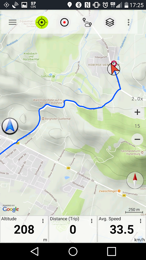
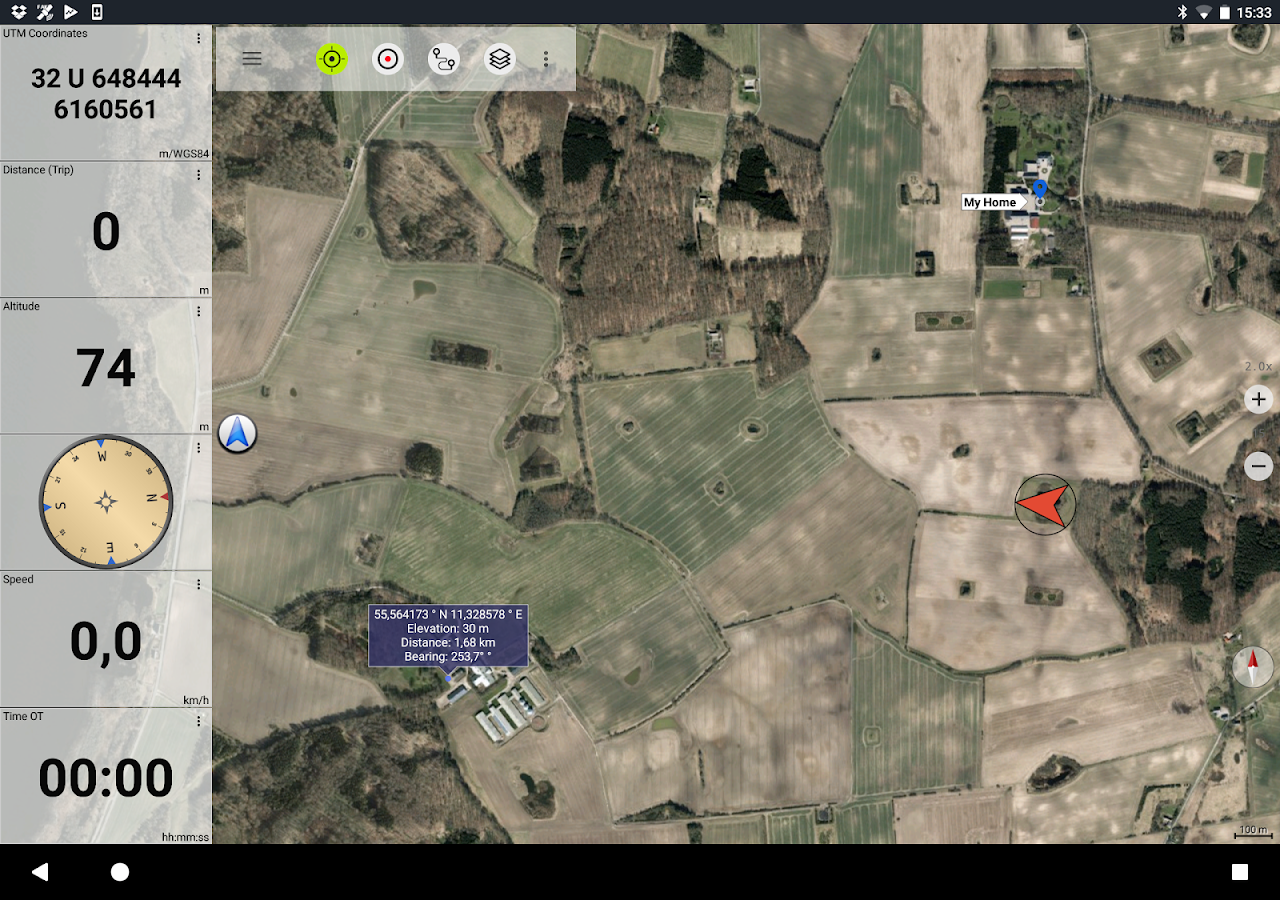
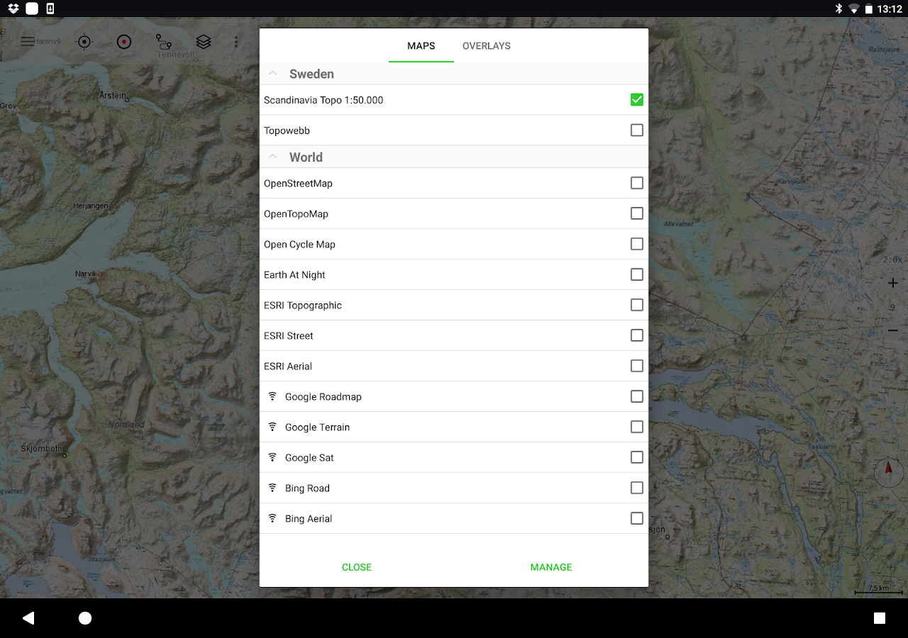
Makes from your phone or tablet a complete GPS device with thedetailed topographic map of France. Viewed maps will be stored onyour device so that Topo GPS can also be used without an internetconnection. Why should you buy an expensive GPS device if you caninstall Topo GPS? Topo GPS contains all functions of a regular GPSdevice for less money, has a much more detailed map, and is moreconvenient to operate. The accuracy of the position determinationis in favorable conditions about 5 m. The price of the detailedtopographic map is 0,99 € for four sections of 4 by 4 km. You getlifetime access to purchased sections including future map updates.You can easily select the sections you need on an overview map. Youget a discount if you buy a large section at once. Purchases aremade available on all devices that share the same Google Playaccount. Ideal for walking, hiking, cycling, mountainbiking,horse-riding, geocaching, trail running and other outdooractivities. Also suited for outdoor professionals. Map * Completetopographic map of France, scale 1:25,000 (SCAN25 from IGN), newestedition. * Very detailed maps, with buildings, cultivation, allroads including the smallest forest trails, contour lines, andcharacteristic elements in the landscape. * Future updates of themap are included for free. * The map can be zoomed and moved. * Allmaps of a certain region can be made offline accessible using themap download screen. * Percentage of map that is offline accessibleis indicated on the top left of the map. * Map tiles can be storedon external storage, like for example an SD-card. Intuitiveinterface * Clear menu with most important functions. * Differentdashboard panels with distance, time, speed, altitude andcoordinates. * Clear manual at www.topo-gps.com. Routes * Recordingof routes, with pause and restart possibility. * Planning of routesvia route points. * Importing routes in gpx and zipped gpx format.* Editing routes. * Sharing routes. * Free access to routecollection Topo GPS. * Searching routes with filters. * Routes canbe organized into folders. * Maps of a route can be made offlineaccessible. Waypoints * Adding waypoints by pressing on map. *Adding waypoints through address or coordinates. * Supportedcoordinate systems: WGS84 decimal, WGS84 degree minutes (seconds),UTM, MGRS and Lambert93. * Importing waypoints in gpx and zippedgpx format. * Sharing waypoints. * Editing waypoints. * Photos canbe added to waypoints. * Searching waypoints with filters. *Waypoints can be organized into folders. Your location * Locationand movement direction indicated by arrowed marker. * Displayablein WGS84 decimal, WGS84 degree minutes (seconds), UTM, MGRS andLambert 93 coordinates. * Sharing and saving as waypoint. In apppurchases * Topographic maps of Belgium, Denmark, Finland, France,Germany, Great Britain, Netherlands, Norway, New Zealand andSweden. * OpenStreetMap world map. If you are recording a route,the GPS will run in the background. Continued use of GPS running inthe background can dramatically decrease battery life. Rdzl, thecompany behind Topo GPS, does not obtain in any way the location ofthe user of Topo GPS. Rdzl does not obtain your routes andwaypoints, unless you share a route with Topo GPS. Rdzl does notregister which map tiles you have downloaded. We sell our product,not our user data.


Topo GPS Spain 6.2.0 APK
Makes from your phone or tablet a complete GPS device with thedetailed topographic map of Spain. Viewed maps will be stored onyour device so that Topo GPS can also be used without an internetconnection. Why should you buy an expensive GPS device if you caninstall Topo GPS on your phone or tablet for only 3,99 €? Topo GPScontains all functions of a regular GPS device for less money, hasa much more detailed map, and is more convenient to operate. Theaccuracy of the position determination is in favorable conditionsabout 5 m. Ideal for walking, hiking, cycling, mountainbiking,horse-riding, geocaching, trail running and other outdooractivities. Also suited for outdoor professionals. Map * Completetopographic map of Spain , newest edition. * Very detailed maps,with buildings, cultivation, all roads including the smallestforest trails, contour lines, and characteristic elements in thelandscape. * Future updates of the map are included for free. * Themap can be zoomed and moved. * All maps of a certain region can bemade offline accessible using the map download screen. * Percentageof map that is offline accessible is indicated on the top left ofthe map. * Map tiles can be stored on external storage, like forexample an SD-card. Intuitive interface * Clear menu with mostimportant functions. * Different dashboard panels with distance,time, speed, altitude and coordinates. * Clear manual atwww.topo-gps.com. Routes * Recording of routes, with pause andrestart possibility. * Planning of routes via route points. *Importing routes in gpx and zipped gpx format. * Editing routes. *Sharing routes. * Free access to route collection Topo GPS. *Searching routes with filters. * Routes can be organized intofolders. * Maps of a route can be made offline accessible.Waypoints * Adding waypoints by pressing on map. * Adding waypointsthrough address or coordinates. * Supported coordinate systems:WGS84 decimal, WGS84 degree minutes (seconds), UTM and MGRS. *Importing waypoints in gpx and zipped gpx format. * Sharingwaypoints. * Editing waypoints. * Photos can be added to waypoints.* Searching waypoints with filters. * Waypoints can be organizedinto folders. Your location * Location and movement directionindicated by arrowed marker. * Displayable in WGS84 decimal, WGS84degree minutes (seconds), UTM and MGRS coordinates. * Sharing andsaving as waypoint. In app purchases * Topographic maps of Belgium,Denmark, Finland, France, Germany, Great Britain, Netherlands,Norway, New Zealand and Sweden. * OpenStreetMap world map. If youare recording a route, the GPS will run in the background.Continued use of GPS running in the background can dramaticallydecrease battery life. Rdzl, the company behind Topo GPS, does notobtain in any way the location of the user of Topo GPS. Rdzl doesnot obtain your routes and waypoints, unless you share a route withTopo GPS. Rdzl does not register which map tiles you havedownloaded. We sell our product, not our user data.

BackCountry Navigator TOPO GPS APK
Download topo maps for an offline outdoornavigator! Use your phone or tablet as an offroad topo mappinghandheld GPS with the bestselling outdoor navigation app forAndroid! Explore beyond cell coverage for hiking and otherrecreation.Download topo maps for the US and many other countries in advance,so you won't need cell coverage for navigation. Use storage memoryfor maps.New: Android Wear support to see navigation at a glance onwristUse GPS waypoints from GPX or KML files, or enter your owncoordinates using longitude/latitude, UTM, MGRS, or grid reference.Using GOTO makes a waypoint a locus for navigation.This uses many publicly available map sources as free downloads.Some additional content available as an in app purchase:-Accuterra Topo Map Source for $19.99/year. This can be purchasedand used with or in instead of the free sources.- Boundary maps for 12 western states from the Bureau of LandManagement(BLM) Overlay for topo maps valued by hunters.-GMU boundaries in some states-Lake Contours in several states.-Content from US TrailMaps including:-ATV, Whitewater, and Equestrian Trail MapsSee the menu under More-> "Purchasing AddOns". They can be shownon top of topo maps.You may try the DEMO version to make sure you like the maps in yourcountry.About topo (topographic) maps: Topo maps show terrain through colorand contours, and are useful for navigation offroad. Topo maps andGPS can be used for hiking, hunting, kayaking, snowshoeing, &backpacker trails.You can create your own maps with Mobile Atlas Creator, or specifya custom tile server. Built in sources include:OpenStreetMaps from MapQuestOpenCycleMaps showing terrain worldwideUS Topo Maps from Caltopo and the USGSUSTopo: Aerial Photography with markup.Canada Topo Maps from ToporamaMarine maps: NOAA RNC Nautical Charts (coastal)USGS Color Aerial photographyTopographic Maps of Spain and ItalyTopo maps of New ZealandJapan GSI maps.Many of the above sources are generally free to use.Use offline topo maps and GPS on hiking trails without cellservice. The GPS in your Android phone can get its position fromGPS satellites, and you don’t have to rely on your data plan to getmaps. Have more fun and safe GPS navigation in thebackcountry.Use as a geocaching navigator by getting a pocket query asGPX.Besides geocaching, use GPS for recording tracks and GPS waypointson your trip, all the while tracking your GPS quest on topographicmaps. It may replace your Garmin handheld GPS.Here are some of the outdoor GPS activities BackCountry Navigatorhas been used for:As a hiking GPS both on hiking trails and off trail.Camping trips to find that perfect camping site or the way back tocamp with GPS.Hunting trips for hunting wild game in rugged areas.Doing recon for a hunt or as your hunting GPSFishing: make it your fishing GPS.Search and Rescue (SAR).Trekking the Pacific Crest trail or other long term hiking.Kayak and canoe treks on inland lakes and streams or marine,coastal waters.Backpacker trips: using topo maps of wilderness areas and nationalforests for navigation on trails with the GPS in your rucksack orbackpack.Find your own ways to have fun in the outdoors. Be a maverick byventuring beyond cell service boundaries with your GPS. Become apro at navigation with GPS for the outdoors.BackCountry Navigator has been on WM devices and preloaded on theTrimble Nomad outdoor rugged device. This Android version is moreflexible, featured, and fun. Create a memory with maps.For a one time fee, this a great addition to the outdoor gear youbought at Cabelas, REI, or another outdoor store. Many have foundthe Android GPS in a phone or tablet to substitute for a Garmin GPSor Magellan GPS, such as the Garmin GPS units Montana, Etrex, orOregon. Android can be your handheld GPS.


