


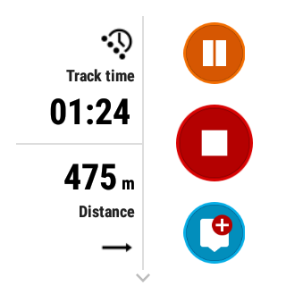
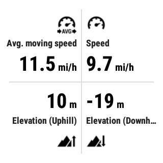

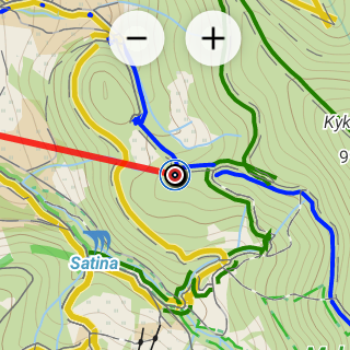


Description
App Information Locus Map Watch
- App NameLocus Map Watch
- Package Namecom.asamm.locus.addon.wear
- UpdatedNov 15, 2023
- File SizeUndefined
- Requires AndroidAndroid
- Version1.6.0
- DeveloperAsamm Software, s. r. o.
- Installs50K+
- PriceFree
- Categoryinfo_outline</i></button></div>
- DeveloperK Odpočinku 3129/8 Praha 9, 193 00 Czech Republic
- Google Play Link
Locus Map Watch Version History
Select Locus Map Watch Version :-
Locus Map Watch 1.5.3 APK File
Publish Date: 2023 /3/2Requires Android: Android 5.0+ (Lollipop, API: 21)File Size: 11.0 MBTested on: Android 13 (Tiramisu, API: 33)File Sha1: 42d30aafebbeec23dfdc284560ffde3e6a090329 -
Locus Map Watch 1.2.0 APK File
Publish Date: 2022 /8/5Requires Android: Android 5.0+ (Lollipop, API: 21)File Size: 6.8 MBTested on: Android 12 (Snow Cone, API: 31)File Sha1: 9024af07867a6dd7557a1d02c6463cd016cbf2dc
Asamm Software, s. r. o. Show More...

Locus GIS - offline geodata collecting, SHP edits 1.10.1 APK
Professional GIS application for offline fieldwork with geodata. Itprovides data collection, viewing, and updating. All its featuresare available above a wide selection of online, offline, and WMSmaps. Fieldwork • offline collecting and updating of field data •saving points with current or arbitrary position • creating linesand polygons by motion recording • settings of attributes • photos,video/audio or drawings as attachments • guidance to pointsImport/Export • importing and editing ESRI SHP files • exportingdata to ESRI SHP or CSV files • exporting whole projects to QGISMaps • wide range of maps both for online use and for download •support of WMS sources • support of offline maps in MBTiles,SQLite, MapsForge, TAR, GEMF, RMAP formats, and customOpenStreetMap data or map themes Tools and features • measuringdistances and areas • searching and filtering of data in theattribute table • style editing and text labels • organizing datainto layers and projects Locus GIS is successfully used in a widerange of industries: • collection of environmental data (ecologicalscanning, tree surveys ...) • forestry management and planning, •agriculture and soil management • gas and energy distribution •planning and construction of wind farms • exploration of miningfields and location of wells • survey and management of urbanfacilities • road constructions and maintenance


Similar Apps Show More...

Locus GIS - offline geodata collecting, SHP edits 1.10.1 APK
Professional GIS application for offline fieldwork with geodata. Itprovides data collection, viewing, and updating. All its featuresare available above a wide selection of online, offline, and WMSmaps. Fieldwork • offline collecting and updating of field data •saving points with current or arbitrary position • creating linesand polygons by motion recording • settings of attributes • photos,video/audio or drawings as attachments • guidance to pointsImport/Export • importing and editing ESRI SHP files • exportingdata to ESRI SHP or CSV files • exporting whole projects to QGISMaps • wide range of maps both for online use and for download •support of WMS sources • support of offline maps in MBTiles,SQLite, MapsForge, TAR, GEMF, RMAP formats, and customOpenStreetMap data or map themes Tools and features • measuringdistances and areas • searching and filtering of data in theattribute table • style editing and text labels • organizing datainto layers and projects Locus GIS is successfully used in a widerange of industries: • collection of environmental data (ecologicalscanning, tree surveys ...) • forestry management and planning, •agriculture and soil management • gas and energy distribution •planning and construction of wind farms • exploration of miningfields and location of wells • survey and management of urbanfacilities • road constructions and maintenance


MyTrails 2.1.11 APK
No ads even in the free version! Perfect for hiking,riding,cycling, running, skiing or orienteering Premium topo mapsUsein-app purchases to subscribe to high-quality,special-purposemaps. Flexible offline mode and competitive pricing.• OS OpenData(GB) • IGN TOP25, TOP50, Cadastre, Satellite andLittoral (marinemaps) (FR) http://www.frogsparks.com/mytrails/ign/Full-screentrail map oriented with the built-in compass and GPSKnow exactlywhich direction you are going. Uncluttered map area,withunobtrusive controls and a traditional scale with trackdurationand distance. Hardware-accelerated map drawing allowssmooth andsnappy display even with tens of thousands of trackpoints. Stats40+ stats to choose from! Display them on a dedicatedscreen(including stats for multiple tracks at once), on theHUDoverlaying the map or even on Android Wear. Graphs Freelydefineaxes (over 30 combinations) to visualize your tracks,includingelevation profiles, speed vs. time, etc. Free online mapsPick frommany built-in online map sources (OpenStreetMap, Yahoo,Bing,Google and many other global and local providers). Add moremapsources using the configurable map sources (URL or WMS).Onlypremium maps are guaranteed: we may be forced to remove accesstoany of the free maps if requested by the rights-holders; thisisregardless of whether you are using the Pro or Freeversion.Offline maps Save battery and data charges. The mapdisplaysinstantaneously. No need to use desktop-based tools tocreateoffline maps, you can do it in MyTrails, in the background.RecordGPS tracks Visualize your track at any time and analyse yourcourseduring or after the outdoor activity. Display multiplecolorizedGPS tracks at once (Pro) Visualize your previous outingsand thoseuploaded to GPS community sites, so that you always pick agreattrail. Visualize the key indicators of the track (altitude,speed,rate of ascent, slope, GPS accuracy, etc.) right on the mapwith adetailed legend. Waypoints Manually add waypoints toindicatememorable spots or upcoming turns. Waypoints areautomaticallygenerated when getting directions or when you take abreak. Shareand archive tracks (Pro) Share your tracks on MyTrails, GPSies,UtagawaVTT and la-trace.com. Download tracks sharedby other usersin your vicinity. Gestures Easily switch betweenactive maps byswiping three fingers left to right in the map view.Pull down theHUD with information on your speed and altitude byswiping threefingers down your screen. Full tablet support Planyour outing on alarge-screen tablet, go out and have fun, and whenyou're back,view the track in full glory. Use Dropbox to seamlesslysynchronizebetween devices. FAQ: http://www.frogsparks.com/faq/Permissions:please see the FAQ


OruxMaps Donate APK
ATTENTION, THIS IS THE VERSION 'DONATE'. IFYOU WANT, YOU CAN TRY THE FREE VERSION, WHICH IS IDENTICAL TOTHIS.IMPORTANT!: NOT ALL ONLINE MAP SOURCES ARE NOW DOWNLOADABLE. SELECTANOTHER SOURCE IF YOU CAN NOT FIND THE OPTION TO DOWNLOAD AMAP.Map viewer, track logger.You can use OruxMaps for your outdoor activities (running, treking,mountain bike, paragliding, flying, nautic sports,....)100% no adversisementsOnline and offline maps. Support to multiple formats:-OruxMaps format. You can use maps from Ozi Explorer transformedwit a PC tool.-.ozf2-.img garmin (vectorial) -no full support is provided-.-.mbtiles-.rmap-.map (vectorial from mapsforge). Support to custom themes similatthan Locus themes.Support to Wms, you can use the application as a WMS viewer.Support to APRS sources.3D view.Support to multiple external devices:-GPS bluetooth.-Heart rate monitors, bluetooth Zephyr, Polar (including bluettohsmart devices, like polar H7).-ANT+ (speed, cadence, heart rate, distance,...).-AIS information systems (experimental), for nautical sports, usingWifi o BT.More features:Support to KML KMZ and GPX formats.Share your position with your friends, display the position of yourfriends in your device.Download online maps for offline use.Text to speech support.Profiles; save your preferences in your SD card.Statistics with graphics.Follow routes, with different alarms to alert you if you are near awaypoint, or you are far from the route.Create/save wayponits, attaching photo/audio/videoextensions.Custom waypoints types, with your icons.Basic support to Geocaching.Correct the altitude of your tracks/routes using DEM files(offline) or online services.Search/download tracks from:-everytrail.com-gpsies.comSearch or create tracks using online services from Cloudmade oroffline using Broute app.Upload tracks to:-mapmytracks.com-trainingstagebuch.org-ikimap-wikirutas-openxploraLive tracking using:-mapmytracks.com-okmap application-gpsgate protocolMore info here: www.oruxmaps.com


