
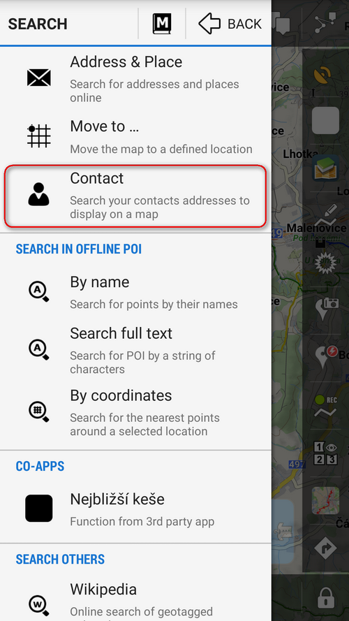
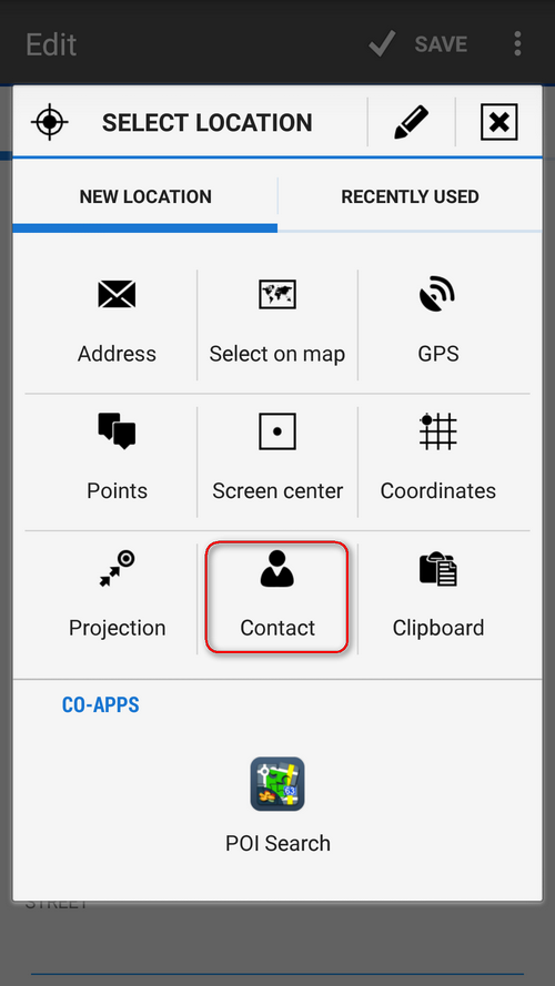
Description
App Information Contacts for Locus Map
- App NameContacts for Locus Map
- Package Namemenion.android.locus.addon.contacts
- UpdatedDec 19, 2014
- File SizeUndefined
- Requires AndroidAndroid 2.2
- Version1.3
- DeveloperAsamm Software, s. r. o.
- Installs100K+
- PriceFree
- Categoryinfo_outline</i></button></div>
- DeveloperK Odpočinku 3129/8 Praha 9, 193 00 Czech Republic
- Google Play Link
Contacts for Locus Map Version History
Select Contacts for Locus Map Version :-
Contacts for Locus Map 1.3 APK File
Publish Date: 2015 /10/9Requires Android: Android 2.2+ (Froyo, API: 8)File Size: 103.8 kBTested on: Android 5.0 (Lollipop, API: 21)File Sha1: 998060853a8b450241467fc376be799282be4fa4
Asamm Software, s. r. o. Show More...

Locus GIS - offline geodata collecting, SHP edits 1.10.1 APK
Professional GIS application for offline fieldwork with geodata. Itprovides data collection, viewing, and updating. All its featuresare available above a wide selection of online, offline, and WMSmaps. Fieldwork • offline collecting and updating of field data •saving points with current or arbitrary position • creating linesand polygons by motion recording • settings of attributes • photos,video/audio or drawings as attachments • guidance to pointsImport/Export • importing and editing ESRI SHP files • exportingdata to ESRI SHP or CSV files • exporting whole projects to QGISMaps • wide range of maps both for online use and for download •support of WMS sources • support of offline maps in MBTiles,SQLite, MapsForge, TAR, GEMF, RMAP formats, and customOpenStreetMap data or map themes Tools and features • measuringdistances and areas • searching and filtering of data in theattribute table • style editing and text labels • organizing datainto layers and projects Locus GIS is successfully used in a widerange of industries: • collection of environmental data (ecologicalscanning, tree surveys ...) • forestry management and planning, •agriculture and soil management • gas and energy distribution •planning and construction of wind farms • exploration of miningfields and location of wells • survey and management of urbanfacilities • road constructions and maintenance


Similar Apps Show More...

Locus GIS - offline geodata collecting, SHP edits 1.10.1 APK
Professional GIS application for offline fieldwork with geodata. Itprovides data collection, viewing, and updating. All its featuresare available above a wide selection of online, offline, and WMSmaps. Fieldwork • offline collecting and updating of field data •saving points with current or arbitrary position • creating linesand polygons by motion recording • settings of attributes • photos,video/audio or drawings as attachments • guidance to pointsImport/Export • importing and editing ESRI SHP files • exportingdata to ESRI SHP or CSV files • exporting whole projects to QGISMaps • wide range of maps both for online use and for download •support of WMS sources • support of offline maps in MBTiles,SQLite, MapsForge, TAR, GEMF, RMAP formats, and customOpenStreetMap data or map themes Tools and features • measuringdistances and areas • searching and filtering of data in theattribute table • style editing and text labels • organizing datainto layers and projects Locus GIS is successfully used in a widerange of industries: • collection of environmental data (ecologicalscanning, tree surveys ...) • forestry management and planning, •agriculture and soil management • gas and energy distribution •planning and construction of wind farms • exploration of miningfields and location of wells • survey and management of urbanfacilities • road constructions and maintenance


TrekMe - GPS trekking offline 3.2.6 APK
TrekMe is an Android app to get live position on a map and otheruseful information, without ever needing an internet connection(except when creating a map). It's ideal for trekking, biking, orany outdoor activity. In this application, you create a map bychosing the area you want to download. Then, your map is availablefor offline usage (the GPS works even without mobile data).Download from USGS, OpenStreetMap, SwissTopo, IGN (France andSpain) Other topographic map sources will be added. Fluid anddoesn't drain the battery Particular attention was given toefficency, low battery usage, and smooth experience. SD cardcompatible A large map can be quite heavy and may not fit into yourinternal memory. If you have an SD card, you can use it. Features •Import, record, and share GPX files • Marker support, with optionalcomments • Real-time visualization of a GPX record, as well as itsstatistics (distance, elevation, ..) • Orientation, distance, andspeed indicators • Measure a distance along a track For instance,all map providers are free, except for France IGN - which requiresan annual subscription. During a GPX recording, the app collectslocation data even when the app is closed or not in use. However,your location will never be shared with anyone and gpx files arestored locally on your device. General TrekMe guidehttps://github.com/peterLaurence/TrekMe/blob/master/Readme.md


MyTrails 2.1.11 APK
No ads even in the free version! Perfect for hiking,riding,cycling, running, skiing or orienteering Premium topo mapsUsein-app purchases to subscribe to high-quality,special-purposemaps. Flexible offline mode and competitive pricing.• OS OpenData(GB) • IGN TOP25, TOP50, Cadastre, Satellite andLittoral (marinemaps) (FR) http://www.frogsparks.com/mytrails/ign/Full-screentrail map oriented with the built-in compass and GPSKnow exactlywhich direction you are going. Uncluttered map area,withunobtrusive controls and a traditional scale with trackdurationand distance. Hardware-accelerated map drawing allowssmooth andsnappy display even with tens of thousands of trackpoints. Stats40+ stats to choose from! Display them on a dedicatedscreen(including stats for multiple tracks at once), on theHUDoverlaying the map or even on Android Wear. Graphs Freelydefineaxes (over 30 combinations) to visualize your tracks,includingelevation profiles, speed vs. time, etc. Free online mapsPick frommany built-in online map sources (OpenStreetMap, Yahoo,Bing,Google and many other global and local providers). Add moremapsources using the configurable map sources (URL or WMS).Onlypremium maps are guaranteed: we may be forced to remove accesstoany of the free maps if requested by the rights-holders; thisisregardless of whether you are using the Pro or Freeversion.Offline maps Save battery and data charges. The mapdisplaysinstantaneously. No need to use desktop-based tools tocreateoffline maps, you can do it in MyTrails, in the background.RecordGPS tracks Visualize your track at any time and analyse yourcourseduring or after the outdoor activity. Display multiplecolorizedGPS tracks at once (Pro) Visualize your previous outingsand thoseuploaded to GPS community sites, so that you always pick agreattrail. Visualize the key indicators of the track (altitude,speed,rate of ascent, slope, GPS accuracy, etc.) right on the mapwith adetailed legend. Waypoints Manually add waypoints toindicatememorable spots or upcoming turns. Waypoints areautomaticallygenerated when getting directions or when you take abreak. Shareand archive tracks (Pro) Share your tracks on MyTrails, GPSies,UtagawaVTT and la-trace.com. Download tracks sharedby other usersin your vicinity. Gestures Easily switch betweenactive maps byswiping three fingers left to right in the map view.Pull down theHUD with information on your speed and altitude byswiping threefingers down your screen. Full tablet support Planyour outing on alarge-screen tablet, go out and have fun, and whenyou're back,view the track in full glory. Use Dropbox to seamlesslysynchronizebetween devices. FAQ: http://www.frogsparks.com/faq/Permissions:please see the FAQ

Shapefile over Map APK
Load your own shapefiles with this GeographicInformation System (GIS) directly from the sdcard of your mobiledevice and visualize them over a map. You can also edit the valuesof its dbf table and use it in offline mode, loading maps from yourmemory card.With this GIS application, you can select and load a shp file orload an entire folder automatically.You can select one of these shp files and mark it as the activelayer and if you use a long press over one of them you can changeits coordinate system, its color or make it invisible.The map will display a series of icons, belonging to each of therecords in the active layer, which when pressed will allow you toview and edit information from its corresponding attributetable.The application also allows you to view your current position viaGPS and center the map on it.You can choose between several online map servers.Support for all UTM Projections (WGS84, SAD69 and NAD83)The .prj file is readed and the coordinate system is automaticallyassigned.Now you can save your sessions (a configured shapefile list).Now also includes a tool to measure distances, areas andperimeters.New tool to search shapes by dbf field valueNew functionality to add and delete dbf fieldsNew functionality to add WMS serversA Quick Help has been addedNew drawing system. Now move the map is fasterMore memory available to load larger shapefiles(only in Androidversions 3.0 or later)New layers administration systemNew tool to load the last sessionNew auto zoom tool to the active layerNew Settings option to change measure units, GPS update time andcharacter codificationsTo use a map in offline mode, simply download it previously (forexample using Mobile Atlas Creator (using OsmAnd tile storageformat)). You must copy the map to the folder you have set onsettings and it should be in the formatMAPNAME/ZOOM/X/Y.png.tile


