


Description
App Information PathAway Outdoor GPS Navigator
- App NamePathAway Outdoor GPS Navigator
- Package Namecom.muskokatech.PathAwayFree
- UpdatedMay 15, 2023
- File SizeUndefined
- Requires AndroidAndroid 5.0
- Version7.15.01
- DeveloperMuskokaTech Inc.
- Installs100K+
- PriceFree
- Categoryinfo_outline</i></button></div>
- Developer151 Holditch St. Bracebridge, Ontario, Canada. P1L 1E8
- Google Play Link
PathAway Outdoor GPS Navigator Version History
Select PathAway Outdoor GPS Navigator Version :-
PathAway Outdoor GPS Navigator 6.03.05.03 APK File
Publish Date: 2016 /12/5Requires Android: Android 2.2+ (Froyo, API: 8)File Size: 11.8 MBTested on: Android 7.0 (Nougat, API: 24)File Sha1: 1318a43bbc80fd5bead71b0e5d4c0d34ace7518b -
PathAway Outdoor GPS Navigator 6.03.00.01 APK File
Publish Date: 2016 /5/13Requires Android: Android 2.2+ (Froyo, API: 8)File Size: 11.8 MBTested on: Android 6.0 (Marshmallow, API: 23)File Sha1: e0c60413f561c4abeacc4aee50ac817046bdf367 -
PathAway Outdoor GPS Navigator 6.02.24.00 APK File
Publish Date: 2016 /2/19Requires Android: Android 2.2+ (Froyo, API: 8)File Size: 10.9 MBTested on: Android 6.0 (Marshmallow, API: 23)File Sha1: 20075c58d20aae017f2b80993b9d9da0f72c23a5 -
PathAway Outdoor GPS Navigator 6.02.23.01 APK File
Publish Date: 2016 /1/9Requires Android: Android 2.2+ (Froyo, API: 8)File Size: 10.2 MBTested on: Android 6.0 (Marshmallow, API: 23)File Sha1: dc5b03a17ca6401a5412916699fdf53d69fd4a11
MuskokaTech Inc. Show More...


PathAway LE - Outdoor GPS Nav 6.03.07.00 APK
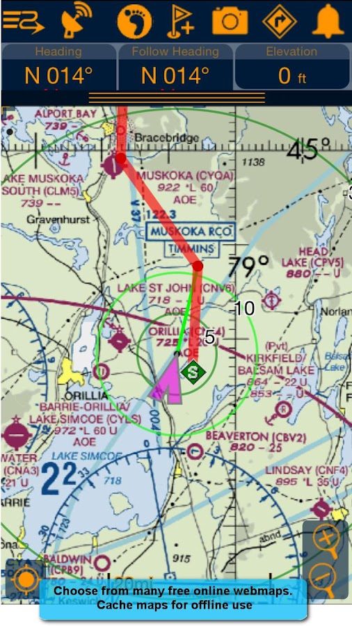
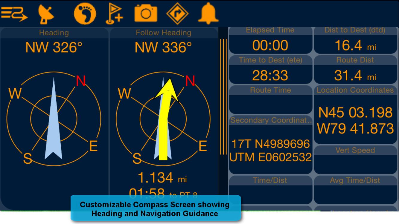
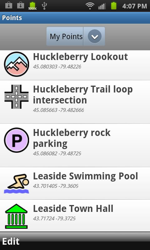
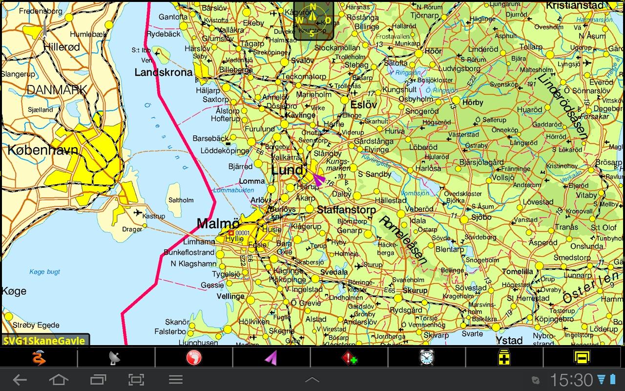
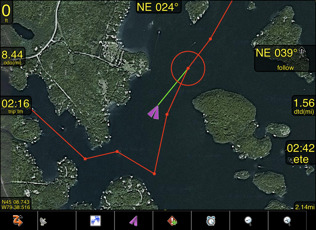
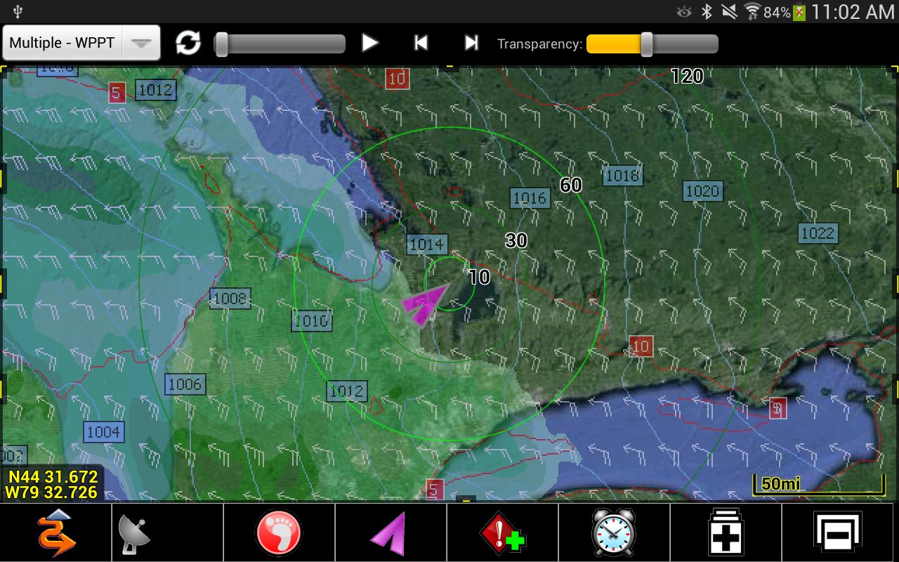
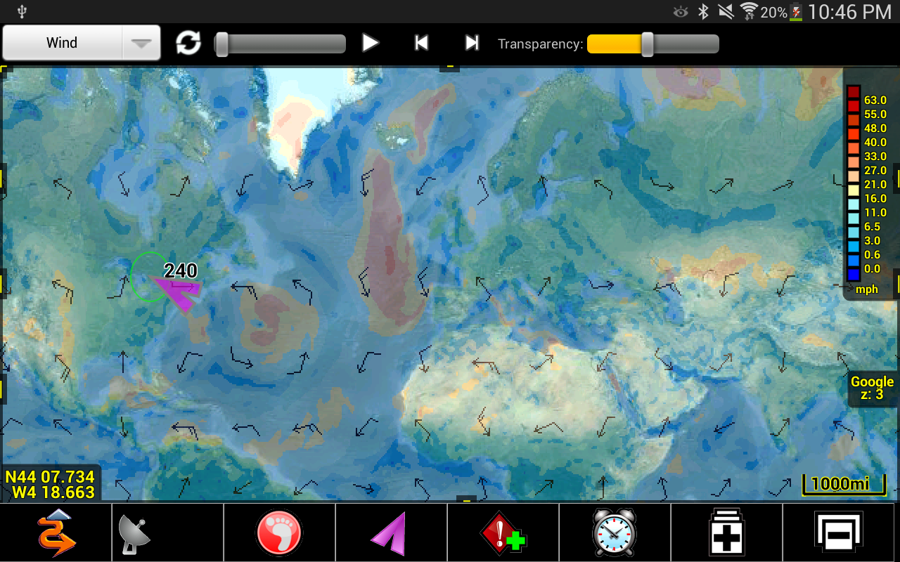
Enjoy hours of outdoor fun with PathAwayguiding, and tracking your way! Mark points of interest, withdetails or photos at those special spots along your route! Navigatewith free online maps that are downloaded on-the-fly and are cachedon the device so they're available when there is no datacoverage.Never get lost again, and track your route so you can explore itagain. Whatever your outdoor adventure is you can use maps thatwill guide you, and track where you are so you can easily get home,or use this route again on your next trip out.Designed for Robust Use.We’ve been developing GPS Apps for mobile devices for over 15years, based on user feedback and recommendations. The creativedesign of PathAway has grown to be the companion you can trust toget you out there, and to bring you back safely. Its time provencore engine manages all the monitoring and recording dataefficiently and robustly. You can count on PathAway to handle themost challenging tasks in the Outdoors.Unparalleled Versatility.PathAway’s features have been carefully designed to embrace thewidest range of activities in the field. PathAway Pro is designedto handle activities from navigating a tight waterway, totraversing a mountain trail, to mapping property boundaries, tocollecting wildlife data.Users have their Say."Perfect for Off Road Navigation!”, “Best GPS App yet!I”, "Allother programs have fallen behind now! So just super. Now, thedream tool is here!!", " The cool thing is that you can layer mapsand switch between them. I have used this for flight, boating andhiking."Maps:- Use online maps from Google maps, OpenStreetMap, OpenCycleMap(Topo), USGS Topos and aerials, FAA USA Aviation charts, ArcGISWorld and USA Topographic, Natural Resources Canada topographicmaps;- Maps are cached for offline use when connectivity is notavailable;- Weather Forecast overlay maps! In real time see weather patternson top of your maps while you travel.Tracking (Breadcrumb):- Log your travels for later analysis, or use as a route to follownext time out.- track in the background while using other applications.- Pause and continue track timer for precision timing;- One touch "BackTrack" feature to find your way home afterrecording your way out;- Store as many Track logs as you like for use later.Points:- Capture points, describe by name, icon, description, photo fromgallery or camera;- Over 100 icons to choose from;- Manage and Edit Points;- Organize your points by creating multiple Points Databases;Navigation:- Navigate directly to a single point or follow multi-pointroutes;- Create navigational routes simply by marking the route on themap;- Alarms to notify you when you've strayed off your route, ornearing a marked point;- Auto Rotate maps to direction of travel;- Uses built-in magnetic compass for slow speed directionallocation. Great for Geocaching when you’re trying to pin-point acache;- View navigational information on the dashboard;- Just want the arrow pointing you which way to go? Use the CompassView.- Import/Export trails or geocaching info in most common formats(GPX, KML, KMZ)Also Available as In-App Purchase:*** PathAway Express Edition:Import or create your own maps. Get maps from web sites, CD-ROM,scanned, or photographed. Import Worldfile, JPR, GeoTiff, or anybitmap image. Display BSB/KAP maps without conversion.*** PathAway Professional Edition:- Location sharing, elevation/speed profile map, UI Customizations:multi-folder support, s, show multiple tracks, routes plusmore...
")
")

Similar Apps Show More...


BackCountry Navigator TOPO GPS APK
Download topo maps for an offline outdoornavigator! Use your phone or tablet as an offroad topo mappinghandheld GPS with the bestselling outdoor navigation app forAndroid! Explore beyond cell coverage for hiking and otherrecreation.Download topo maps for the US and many other countries in advance,so you won't need cell coverage for navigation. Use storage memoryfor maps.New: Android Wear support to see navigation at a glance onwristUse GPS waypoints from GPX or KML files, or enter your owncoordinates using longitude/latitude, UTM, MGRS, or grid reference.Using GOTO makes a waypoint a locus for navigation.This uses many publicly available map sources as free downloads.Some additional content available as an in app purchase:-Accuterra Topo Map Source for $19.99/year. This can be purchasedand used with or in instead of the free sources.- Boundary maps for 12 western states from the Bureau of LandManagement(BLM) Overlay for topo maps valued by hunters.-GMU boundaries in some states-Lake Contours in several states.-Content from US TrailMaps including:-ATV, Whitewater, and Equestrian Trail MapsSee the menu under More-> "Purchasing AddOns". They can be shownon top of topo maps.You may try the DEMO version to make sure you like the maps in yourcountry.About topo (topographic) maps: Topo maps show terrain through colorand contours, and are useful for navigation offroad. Topo maps andGPS can be used for hiking, hunting, kayaking, snowshoeing, &backpacker trails.You can create your own maps with Mobile Atlas Creator, or specifya custom tile server. Built in sources include:OpenStreetMaps from MapQuestOpenCycleMaps showing terrain worldwideUS Topo Maps from Caltopo and the USGSUSTopo: Aerial Photography with markup.Canada Topo Maps from ToporamaMarine maps: NOAA RNC Nautical Charts (coastal)USGS Color Aerial photographyTopographic Maps of Spain and ItalyTopo maps of New ZealandJapan GSI maps.Many of the above sources are generally free to use.Use offline topo maps and GPS on hiking trails without cellservice. The GPS in your Android phone can get its position fromGPS satellites, and you don’t have to rely on your data plan to getmaps. Have more fun and safe GPS navigation in thebackcountry.Use as a geocaching navigator by getting a pocket query asGPX.Besides geocaching, use GPS for recording tracks and GPS waypointson your trip, all the while tracking your GPS quest on topographicmaps. It may replace your Garmin handheld GPS.Here are some of the outdoor GPS activities BackCountry Navigatorhas been used for:As a hiking GPS both on hiking trails and off trail.Camping trips to find that perfect camping site or the way back tocamp with GPS.Hunting trips for hunting wild game in rugged areas.Doing recon for a hunt or as your hunting GPSFishing: make it your fishing GPS.Search and Rescue (SAR).Trekking the Pacific Crest trail or other long term hiking.Kayak and canoe treks on inland lakes and streams or marine,coastal waters.Backpacker trips: using topo maps of wilderness areas and nationalforests for navigation on trails with the GPS in your rucksack orbackpack.Find your own ways to have fun in the outdoors. Be a maverick byventuring beyond cell service boundaries with your GPS. Become apro at navigation with GPS for the outdoors.BackCountry Navigator has been on WM devices and preloaded on theTrimble Nomad outdoor rugged device. This Android version is moreflexible, featured, and fun. Create a memory with maps.For a one time fee, this a great addition to the outdoor gear youbought at Cabelas, REI, or another outdoor store. Many have foundthe Android GPS in a phone or tablet to substitute for a Garmin GPSor Magellan GPS, such as the Garmin GPS units Montana, Etrex, orOregon. Android can be your handheld GPS.


BackCountry Nav Topo Maps GPS APK
Use your Android as an offroad topo mappingGPS with the bestselling outdoor navigation app for Android! Trythis DEMO to see if it is right for you, then upgrade to the paidversion.Use offline topo maps and GPS on hike trails without cell service!The GPS in your Android phone can get its position from satellites,and you don’t have to rely on your data plan to get maps. Have morefun and safe GPS adventures in the backcountry.Preload FREE offline topo maps, aerial photos, and road maps onyour storage memory, so they are ready when you need them.Add custom GPS waypoints in longitude and latitude, UTM or MGRSgrid reference. Import GPS waypoints from GPX files. Choose iconsfor waypoints much like in MapSource. (This app uses the WGS84datum, NAD27 is available in settings).Use GPS for hunting a waypoint or geocache, for recording tracksand GPS waypoints on your trip, all the while tracking your queston topographic maps.About topo (topographic) maps: Topo maps show terrain through colorand contours, and are useful for navigation offroad. Topo maps andGPS can be used for hiking, hunting, kayaking, snowshoeing, &backpacker trails.The app has many built in map sources and allows you to create yourown maps with Mobile Atlas Creator. Built in sources include:OpenStreetMaps and NASA landsat data worldwide.OpenCyle Maps are topo maps that show terrain worldwide.USGS Color Aerial photography.Topographic Maps of Spain and Italy.Outdoor maps of Germany and AustriaTopo maps of New ZealandHere are some of the outdoor GPS activities BackCountry Navigatorhas been used for:Hiking both on hiking trails and off trail.Camping, to find the perfect camping site or the way back tocamp.Hunting trips for hunting wild game in rugged areas, includingrecon for the hunt.Bait fishing or fly fishing with a buddy.Search and Rescue (SAR) with GPS.Kayak and canoe trips on inland lakes and streams or marine,coastal waters.Backpacker trips: using topo maps of wilderness areas and nationalforests to navigate on trails with the GPS.Snow adventures including snowmobiling, skiing (alpine or crosscountry) and snowshoeing. Create a memory. Map it out.This a great addition to the outdoor gear you bought at Cabelas,REI, or another outdoor store. Your android phone could substitutefor a Garmin or Magellan outdoor handheld GPS! You storage hasmemory for maps.Find your own ways to have fun in the outdoors. Be a maverick byventuring into new territory beyond cell service boundaries. Becomea pro at navigation with GPS.BackCountry Navigator has been previously available on WM devicesand preloaded on the Trimble Nomad outdoor rugged device. ThisAndroid version is more flexible, featured, and fun.


MyTrails 2.1.11 APK
No ads even in the free version! Perfect for hiking,riding,cycling, running, skiing or orienteering Premium topo mapsUsein-app purchases to subscribe to high-quality,special-purposemaps. Flexible offline mode and competitive pricing.• OS OpenData(GB) • IGN TOP25, TOP50, Cadastre, Satellite andLittoral (marinemaps) (FR) http://www.frogsparks.com/mytrails/ign/Full-screentrail map oriented with the built-in compass and GPSKnow exactlywhich direction you are going. Uncluttered map area,withunobtrusive controls and a traditional scale with trackdurationand distance. Hardware-accelerated map drawing allowssmooth andsnappy display even with tens of thousands of trackpoints. Stats40+ stats to choose from! Display them on a dedicatedscreen(including stats for multiple tracks at once), on theHUDoverlaying the map or even on Android Wear. Graphs Freelydefineaxes (over 30 combinations) to visualize your tracks,includingelevation profiles, speed vs. time, etc. Free online mapsPick frommany built-in online map sources (OpenStreetMap, Yahoo,Bing,Google and many other global and local providers). Add moremapsources using the configurable map sources (URL or WMS).Onlypremium maps are guaranteed: we may be forced to remove accesstoany of the free maps if requested by the rights-holders; thisisregardless of whether you are using the Pro or Freeversion.Offline maps Save battery and data charges. The mapdisplaysinstantaneously. No need to use desktop-based tools tocreateoffline maps, you can do it in MyTrails, in the background.RecordGPS tracks Visualize your track at any time and analyse yourcourseduring or after the outdoor activity. Display multiplecolorizedGPS tracks at once (Pro) Visualize your previous outingsand thoseuploaded to GPS community sites, so that you always pick agreattrail. Visualize the key indicators of the track (altitude,speed,rate of ascent, slope, GPS accuracy, etc.) right on the mapwith adetailed legend. Waypoints Manually add waypoints toindicatememorable spots or upcoming turns. Waypoints areautomaticallygenerated when getting directions or when you take abreak. Shareand archive tracks (Pro) Share your tracks on MyTrails, GPSies,UtagawaVTT and la-trace.com. Download tracks sharedby other usersin your vicinity. Gestures Easily switch betweenactive maps byswiping three fingers left to right in the map view.Pull down theHUD with information on your speed and altitude byswiping threefingers down your screen. Full tablet support Planyour outing on alarge-screen tablet, go out and have fun, and whenyou're back,view the track in full glory. Use Dropbox to seamlesslysynchronizebetween devices. FAQ: http://www.frogsparks.com/faq/Permissions:please see the FAQ


