


Description
App Information WiFi GPS
- App NameWiFi GPS
- Package Namecn.bluedrum.gps.wifi
- UpdatedMay 14, 2013
- File Size1.1M
- Requires AndroidAndroid 2.1 and up
- Version1.08
- Developerwork4blue.com
- Installs1,000 - 5,000
- PriceFree
- CategoryTransportation
- Developer
- Google Play Link
WiFi GPS Version History
Select WiFi GPS Version :-
WiFi GPS 1.08 APK File
Publish Date: 2016 /1/11Requires Android: Android 2.1+ (clair, API: 7)File Size: 1.1 MBTested on: Android 4.0 (Ice Cream Sandwich, API: 14)File Sha1: 21e58b960906a61ccb4483fa7da6f2604acbf2c6
work4blue.com Show More...


WiFi GPS 1.08 APK
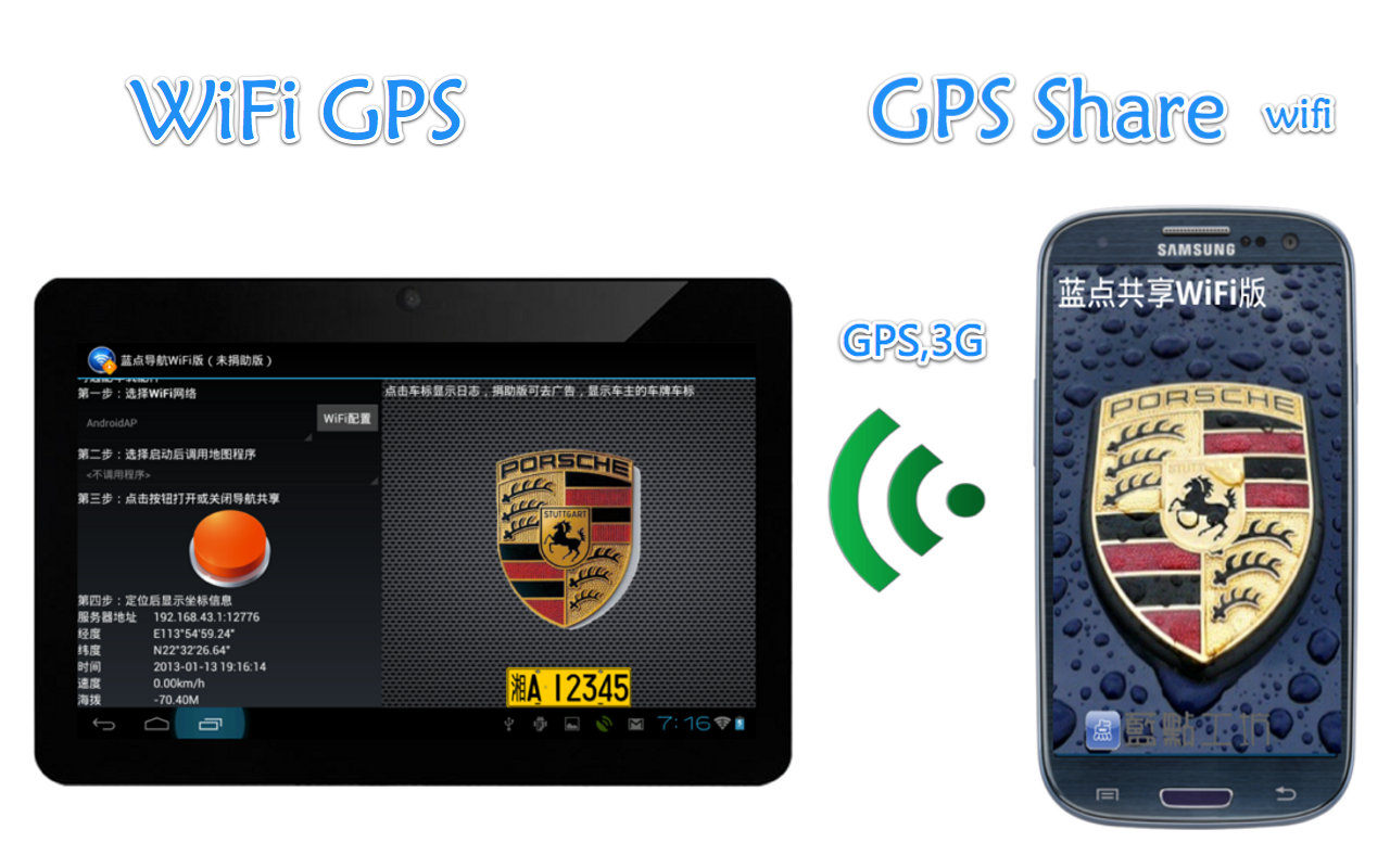
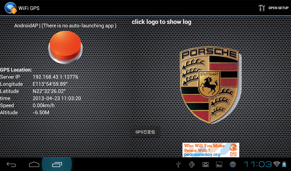
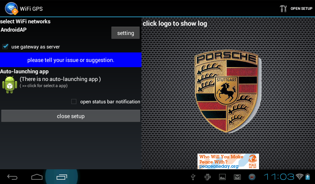
WiFi GPS is an Android tablet app thatreceives GPS data via WiFi.It lets any tablet become navigator right now.☆The app is specifically designed for large phone and tablet.☆Turn on WiFi, GPS , Audio volume and launch map app in onetouch.☆Many tablet has been tested. This app is compatible with most ofthe CPU,for example, Allwinner A10/A13, Rockship RK3066,Amlogic AML8765 ...☆In a file /system/build.prop to change a line: gps.enable=falseon gps.enable=true if tablet's CPU is Amlogic, such as Aniol fire,W22 Pro.☆This app receives NMEA data from the other Android phone thatinstalled "GPS Share WiFi"(https://play.google.com/store/apps/details?id=cn.bluedrum.share.wifi).This Android phone must support GPS and WiFi.☆Specialized power-saving design, can be used WiFi in standbystate.☆Support three NMEA output format:GPS, Russian GLNOSS and ChineseBeidou (BD2).We welcome to get feedback from our customers. If you have anissue or suggestion,please send us an e-mail to [email protected] . or G+ me byhttp://goo.gl/hE8ke.

USB GPS 1.08 APK
USB GPS is an Android tablet app that receives GPS data viaUSB.It lets any tablet become navigator right now.☆The app is specifically designed for large screen phone andtablet.☆Turn on GPS , Audio volume and launch map app in one touch.☆tablet or phone need rooted, and kernel has USB Serial driver,etc. PL2303☆Support three NMEA output format:GPS, Russian GLNOSS andChinese Beidou (BD2).We welcome to get feedback from our customers. If you have anissue or suggestion,please send us an e-mail to [email protected] . or G+ me byhttp://goo.gl/hE8ke.

GPS Share BT 1.07 APK
Android phone become a Bluetooth GPS modulethat the Android Tablet and iPad can navigate.☆Support send NMEA data to Android Tablet without GPS so that itcan navigate. Tablet needto install BT GPS(https://play.google.com/store/apps/details?id=cn.bluedrum.gps.bt).All tablet support !☆Support send NMEA data to Wi-Fi-only iPad so that it can navigate.IPad needto install roqyBT4 or BTstack GPS.☆Support three NMEA output format:GPS, Russian GLNOSS and ChineseBeidou (BD2).☆Turn on Bluetooth, GPS and 3G data in one touch.We welcome to get feedback from our customers. If you have anissue or suggestion,please send us an e-mail to [email protected] . Or G+ meby http://goo.gl/hE8ke.

GPS Share WiFi 1.06 APK
Android phone become a GPS /3G module thatthe Android Tablet and iPad can navigate.☆Support send NMEA data to Android Tablet without GPS so that itcan navigate. Tablet needto install WiFi GPS(https://play.google.com/store/apps/details?id=cn.bluedrum.gps.wifi).All tablet support !☆Support Tablet use phone 3G data.☆Support three NMEA output format:GPS, Russian GLNOSS andChinese Beidou (BD2).☆Turn on WiFi, GPS and 3G data in one touch.We welcome to get feedback from our customers. If you have anissue or suggestion,please send us an e-mail to [email protected] . or G+ me byhttp://goo.gl/hE8ke.
Similar Apps Show More...

Easy Auto PRO 1.0 APK
Easy Auto Easy solution for make driving easier and safer Thenewtool which lets us access all important settings duringourdriving. It has such an easy interface where you'll find easywhatto do ★SELECT THE NAVIGATOR: Quick access to Google Mapsservice.★PHONE YOUR CONTACTS: Open the dial without having anaccident ordistractions. ★MUSIC ACCESS: Quickly access to yourmusic. Soconnect your mobile easily to your car speakers. ★FINDYOUR CARLAST LOCATION: After each driving, save your location,you'll besaving your current location to easy remember the placewhere youlast parked your car.You can alternate between 3differentsearching modes: Google Maps, Radar View and 3D augmentedRealityView ★AND MORE OPTIONS: Customize you background interface,yourbutton's colors, language. ★VERY EASY TO USE. This tool isdesignedfor your comfort and it'll try to bring you the bestdrivingexperience ★MOST IMPORTANT. We are open to you! We are opento anysuggestions or improvements you could think would be betterto theapp =D! Thank you for downloading this app. Enjoy the app,and rateus to make us improve.

Easy Auto 6.3 APK
Easy GPS Navigation Easy solution for make driving easier andsaferThe new tool which lets us access all important settingsduring ourdriving. It has such an easy interface where you'll findeasy whatto do ★SELECT THE NAVIGATOR: Quick access to Google Mapsservice.★PHONE YOUR CONTACTS: Open the dial without having anaccident ordistractions. ★MUSIC ACCESS: Quickly access to yourmusic. Soconnect your mobile easily to your car speakers. ★FINDYOUR CARLAST LOCATION: After each driving, save your location,you'll besaving your current location to easy remember the placewhere youlast parked your car.You can alternate between 3differentsearching modes: Google Maps, Radar View and 3D augmentedRealityView ★AND MORE OPTIONS: Customize you background interface,yourbutton's colors, language. ★VERY EASY TO USE. This tool isdesignedfor your comfort and it'll try to bring you the bestdrivingexperience ★MOST IMPORTANT. We are open to you! We are opento anysuggestions or improvements you could think would be betterto theapp =D! Thank you for downloading this app. Enjoy the app,and rateus to make us improve.

BackCountry Nav Topo Maps GPS APK
Use your Android as an offroad topo mappingGPS with the bestselling outdoor navigation app for Android! Trythis DEMO to see if it is right for you, then upgrade to the paidversion.Use offline topo maps and GPS on hike trails without cell service!The GPS in your Android phone can get its position from satellites,and you don’t have to rely on your data plan to get maps. Have morefun and safe GPS adventures in the backcountry.Preload FREE offline topo maps, aerial photos, and road maps onyour storage memory, so they are ready when you need them.Add custom GPS waypoints in longitude and latitude, UTM or MGRSgrid reference. Import GPS waypoints from GPX files. Choose iconsfor waypoints much like in MapSource. (This app uses the WGS84datum, NAD27 is available in settings).Use GPS for hunting a waypoint or geocache, for recording tracksand GPS waypoints on your trip, all the while tracking your queston topographic maps.About topo (topographic) maps: Topo maps show terrain through colorand contours, and are useful for navigation offroad. Topo maps andGPS can be used for hiking, hunting, kayaking, snowshoeing, &backpacker trails.The app has many built in map sources and allows you to create yourown maps with Mobile Atlas Creator. Built in sources include:OpenStreetMaps and NASA landsat data worldwide.OpenCyle Maps are topo maps that show terrain worldwide.USGS Color Aerial photography.Topographic Maps of Spain and Italy.Outdoor maps of Germany and AustriaTopo maps of New ZealandHere are some of the outdoor GPS activities BackCountry Navigatorhas been used for:Hiking both on hiking trails and off trail.Camping, to find the perfect camping site or the way back tocamp.Hunting trips for hunting wild game in rugged areas, includingrecon for the hunt.Bait fishing or fly fishing with a buddy.Search and Rescue (SAR) with GPS.Kayak and canoe trips on inland lakes and streams or marine,coastal waters.Backpacker trips: using topo maps of wilderness areas and nationalforests to navigate on trails with the GPS.Snow adventures including snowmobiling, skiing (alpine or crosscountry) and snowshoeing. Create a memory. Map it out.This a great addition to the outdoor gear you bought at Cabelas,REI, or another outdoor store. Your android phone could substitutefor a Garmin or Magellan outdoor handheld GPS! You storage hasmemory for maps.Find your own ways to have fun in the outdoors. Be a maverick byventuring into new territory beyond cell service boundaries. Becomea pro at navigation with GPS.BackCountry Navigator has been previously available on WM devicesand preloaded on the Trimble Nomad outdoor rugged device. ThisAndroid version is more flexible, featured, and fun.

SpeedView: Legacy Edition 4.0.2 APK
SpeedView is an advanced speedometer application that usesthephone's built-in GPS system to show your current, maximumandaverage speed, as well as the direction, total distance, andtimetraveled. Suitable for running, car driving, biking, or hiking.•High accuracy GPS-based speedometer that is more accurate thantheone in your car. • Linear compass Shows your current directionoftravel. A compass mode is also available. • HUD mode Mirrorsthenumbers so you can place your phone on your car's dashboard andseethe speed reflected in the front glass. You can check outthisvideo to see how it works: http://youtu.be/rzda7CQ-ZAU •Speedgraph Displays a graph chart covering the last severalminutes. •Speed warning You can set the speed limits for threedifferenttypes of roads so that when you go too fast a visual alertor soundwill notify you. • Display units Supports units such asmiles,kilometers, and nautical miles. • GPX track export Enablesyou tosave your current track to the SD card or email it tosomeone. TheGPX format is supported by Google Earth and many otherprograms:http://www.topografix.com/gpx_resources.asp • Backgroundmode Youcan minimize the program and keep it running in thebackground. Itwill work as usual and even notify you when youexceed the speedlimit. Please note that the accuracy of GPSmeasurements isaffected by a number of factors includingatmospheric conditions,obstructions and the visibility ofsatellites. We use Sense360, athird party technology provider, tohelp us better understand howour users use SpeedView and theirdevices. SpeedView sends rawsensor data generated by your device toSense360. This sensor datamay include information from GPSreceivers, accelerometers,gyroscopes, and other sensors, which mayallow Sense360 todetermine, for example, your device’s location,acceleration, andorientation. Sense360 may use this data to send usanalytic reportsregarding how our users are using SpeedView andtheir devices, orfor marketing purposes. To learn more, pleasevisit Sense360’sprivacy policy, availableat:http://sense360.com/privacy-policy.html. This versionisad-supported. A paid version without ads and more features isalsoavailable. If you have any questions or comments, feel free topostthem on our blog: http://blog.codesector.com/

GPS Speedometer Free 1.17 APK
GPS Speedometer is a speedometer application that uses yourphone'sinternal GPS module to calculate your current speed anddisplay itwith large, easy to read, LCD-like fonts. It will alsodisplay yourtotal travel time, your average speed, maximum reachedspeed, yourheading and elevation, a nice compass and forward andlateralaccelerations. #### Now with HUD (head-up display) mode* -justpress "Menu" - "Enable HUD mode" and put your phone face up onthedashboard, under the windshield; the screen will be mirrored anditwill be reflected by the windshield. *HUD mode needs more CPUpowerthan normal mode. This is a free version, supported byads.Features: - HUD mode - High accuracy. The speed valuecalculatedfrom GPS data is more accurate than the one displayed byyour car'sspeedometer - It supports both imperial and metric units- 5predefined color themes available - It can record your path,speed,distance, and elevation and save them in a KML file (forGoogleEarth) - just press "Menu", select "Settings" and "Recordtrack". -It can work in the background, so it can record yourmovement andspeed even while you're talking on the phone. Thismeans that ifyou really want to exit the application, you have topress "Menu"and select "Exit". It requires the followingpermissions: -WAKE_LOCK in order to prevent the screen from turningoff -ACCESS_FINE_LOCATION (GPS based location) for reading GPS data-WRITE_EXTERNAL_STORAGE in order to save the KML file - INTERNETinorder to retrieve ads from ad servers. Please note that whileI'vetested the application on several Android devices, there areway tomany different Android devices to guarantee that it will workjustfine on all of them, so if you encounter a problem withtheapplication, just drop me an email with your phone model andashort description of your problem; I will do my best to fixitASAP. Also, please note that this application comes with NOSUPPORTwhatsoever. I'm just one guy who develops apps as a hobby,in mylittle free time that I have. If you have a problem, I will domybest to fix it, but I can't guarantee that it will be as fastasyou might like it. Likewise, I will also do my best to replytoemails, but the truth is that sometimes I'm overwhelmed.
GPS Tracker Car TK SMS APK
Austral GPS Tracker (GPS Tracking by SMS GSM)helps you to track and set your GPS Tracker from a huge number ofmanufacturers (Xexun and full list in the end).Tired of sending complex SMS to your GPS Tracker Xexun or clonedevices, or paying monthly fees to someone track your car ormotorcycle? How about controlling your device with a few clicksfrom your Android smartphone?With the Austral GPS Car Tracker you can monitor your vehicles(boat, etc), people and animals tracked by devices Xexun and othersfrom your Droid smartphone with a few clicks at a cost of SMSmessages.On the main screen just select the brand, model, phone numberand password of your GPS Tracking and click OK.In our app we have 4 main screens:- Dashboard: where you can check your vehicle’s current location,speed and distance from your smartphone. All of these in a simpleand intuitive screen with a map.- Locations: when and where your vehicle went since you installedthe app. Also it shows the real address of that location, no moreLatitude and Longitude!- Events: know the commands you sent and received from your devicein an easily reading form that anyone can understand.- Settings: here you can send some commands to your device likechanging the password, change the GPS mode, listen to your car, cutvehicle’s engine, GeoFence, define over speed and move alerts andmuch more.You also receive light and sound warnings indicating that thevehicle was moved, if the alarm was triggered, SOS was pressed orthe vehicle was exceeding the speed you defined!EXCLUSIVE FEATURE! Now you can define your GeoFence using a mapby pressing the threshold points you want (top left and bottomright) and then send it to your tracker.Fuel Control: Control your spending on fill ups! Know your car'sefficiency.Please, uninstall the free version if you install the full oneto avoid receiving SMS in the wrong version.You can find the manual and some tips in our blog.http://australsystems.wordpress.com/Available in english, portuguese, spanish, italian, german,french, dutch, polski and русский.If you have any questions or suggestions, please do not hesitateto contact us via [email protected] before giving us a badreview. If you have an idea, send us!Also we are working hard to make it compatible with anothertrackers or clone devices, so if you have something that isn’tworking like it should, just send us an email with the SMS messagethat we will fix it as soon as possible.*****Compatible with:- Xexun TK 103-2, TK 103, TK 102-2, TK 102, TK 101, TK 201-2, TK201, TK 202, TK 203, TK 206, XT 008, XT 009, XT 107- SmarTrack KX300, KX301, KX302, KX402- ZY International TK 102B, TK 103, TK 103B, TK 104, TK 106, TK106B, TK 008- Coban GPS 103-B, GPS 103-A, GPS 102-B, GPS 102, GPS 107, GPS106-B, GPS 106-A, GPS 104, GPS 301, GPS 302, GPS 303, GPS 304, GPS305, GPS 306- Zclelec GPS TK 203, GPS TK 201- ELRO GPS1- Meitrack/Meiligao VT300, VT310, VT400, GT30i, GT60- Technaxx GPS Tracker 1- Timson TK 104, TK 103-2, TK 102-2, TK 103, TK 102- Orange TK 103, TK 102- GPS Vision TK 102 V6, TK 102 V3- Anywhere TK 108, TK 106- PowerTrack TK105- Hashtag # TK 102

GPS altimeter APK
Altimeter is a free to use the functionalityof the GPS.Current position on the map, advanced GPS, elevation map isdisplayed.Please click the button at the point you want to measure.Please use the setting to ON GPS.Also any problems caused by downloading this software Note)installed, but its responsibilities.Please use at your own risk.


GPS ILS 1.3.67 APK
VFR flight ONLY!!!(1) Voice vertical guidance into any airport. This helps flyingconsistent & safer short field VFR approaches into runways withno vertical guidance.(2) "Flight Analysis" to review the approach precision and improvefrom feedback on every flight.============================================================How does it work? (reference 1st App Screenshot)* Connect Phone audio to headset, adjust audio volume* Select desired approach* Identify "Green Arrow" in HSI and turn aircraft to Top ofDescent. (67 deg)* Localizer bar is "red" indicating that loc is past the rightlimit.* Localizer will turn "yellow" once in range* "White Arrow" in HSI is the direction of touchdown point. (60deg)* "Yellow Arrow" in HSI is the direction of final approach course.(37 deg)* Descent to "TOD altitude" (top of descent) using aircraftaltimeter as reference* Now a GREEN glide slope bar will appear and be centered* As we approach the TOD and the synthetic ILS GP in "yellow" iscoming down* YELLOW ILS glide slope and the GREEN TOD glide slope will mergeat TOD* Passing the TOD turn to the final approach course shown as"yellow" arrow* Descent with the YELLOW ILS glide slope* Voice will announce: "50 up", "Center", "Down 100" etc....* Menu: "Request Flight Analysis" after landing, suggest connectingvia wifi* Examples and details at: http://www.reuter-family.com/gpsils/GPSILS_Details.pdf.Thank You to Timothy Nathan===============================================================Watch the example video of on an actual ILS:www.youtube.com/watch?v=85AdUUd-kZwWe are approaching the localiser on a 125 heading and a TODaltitude of 1200ft. We are about 60 ft too low. The Green, Whiteand Yellow arrows show the direction to the TOD point, thetouchdown zone and the approach course respectively.As the localizer comes in we turn to 207 for the intercept.As we approach the TOD the Green and Yellow GP merge. The greenarrow swings around to the left indicating that we pass TOD on theright.The decent with the GP starts. The white arrow is now hiddenbehind the yellow arrow. The TOD is now behind us and hence thegreen arrow is pointing to our 6 o' clock position.The voice announcement are suppressed. However you can see theannouncements in the upper left of the phone screen. "Up 80" forexample. The app shows an altitude of 510 ft at touchdown.According to the charts the runway is at 517 ft.Once we pass the touchdown zone the white arrow moves to the 6o'clock position.Note, we used an external Bluetooth GPS on the glare shield witha 5 Hz update frequency. Any change in color of the "accuracy"field indicates a new GPS data point. CAUTION, usage of theinternal phone GPS may materially reduce the accuracy.http://www.youtube.com/watch?v=HqyAXyufBK8&feature=youtu.beshows a good match between GPS and ILS. At 1000 ft agl the towerswitches the approach from circle to land to straight in. Comparethe two glide slopes.Further comparison of the app to an actual ILS: http://www.youtube.com/watch?v=TGLHkozNBRwCourchevel with Audio announcement for altitude correction:www.youtube.com/watch?v=P__OlISD3xgScenic Courchevel (LFLJ) approach:www.youtube.com/watch?v=uNFNFZq2BFYThe app asks for the pilots e-mail address. The address isattached to log files and makes it possible to send comments back.Privacy is ensured. Upload/download of data may best be done whenconnected to internet via wifi. The data stays private.To add more approaches drop me an e-mail or press the requestbutton on the phone. 37,000 approaches can be down loaded via"Menu->Download Approaches".Comments to: [email protected]: The software and data is as is. The author assumes noresponsibility or liability either directly or indirectly.Big "Thank You" to Mark Rae and Timothy Nathan who worked onimproving the UI, database checks and test flights.
Transportation Top Show More...


Speed Limiter 2.0 APK
Tired of fines? Speed limiter is there for you!Speed Limiter is an application whose purpose is to warn youin case you drive too fast. It works thanks to the GPS on yourphone.Its simple and clear, you can use it without leaving theroad.The last button indicates the speed at which you drive. Byselecting, you dynamically create a new limitation.

Drive Link 1.1.043 APK
DriveLink is a perfect app for safe, handsfree in-vehicle services that really makes a difference in thedriving.The app can either work as Standalone Mode, which is just launchedin the smartphone, or as Connected Mode,which works by connecting to the car's headunit display viaMirrorLink(TM).For the Connected Mode, the screen of the smartphone is mirroredto the head unit display.The app has been designed to conform to the safety regulation setby Automotive industry standard.The current version has the following features:- Welcome Screen: Context Awareness feature that allows todisplay the current location's weather information,Recently Played Music in the smartphone, Schedule info stored inCalendar app. If the schedule contains an address, the user canclick theaddress to directly navigate to the destination- Music : User can listen to every music file stored in thesmartphone. Also, DriveLink has other music sources such asInternet Radio.Currently, TuneIn and Radioclock App is available.- Phone: User can make a phone call, and send text messages. Theapp retrieves all contact information stored in the smartphone- Shortcut: User can create a shortcut for a specific contact,music, and location.Note:- To use MirrorLink(TM) service in car using USB, the head unitmust support MirrorLink(TM) 1.0.1.- If MirrorLink(TM) service doesn't work in your smartphone, it isnecessary to update a firmware.- Firmware update availability is depending on mobileoperators.

myIowaDOT 1.1.12 APK
The myIowaDOT app has been developed to act as a container forother Iowa Department of Transportation apps. It shows allavailable Iowa Department of Transportation apps, even those appsthat are not currently installed on the device. If an app isselected that is not installed on the device, the user is taken tothat app in Google Play so the app can be installed. Once apps havebeen installed, the myIowaDOT app can be used as a launch pad forthose apps.The list of apps available on the myIowaDOT app is builtdynamically, so new apps will automatically appear in the myIowaDOTapp as they are developed. Users can also create a list of favoriteapps, personalized to meet their needs.Apps that are currently available with myIowaDOT include:Aviation - Contains an Iowa airport directory, aviation weather, anaviation calendar, and NOTAMS (Notice to Airmen)Bike Map - An interactive bike map with bike trail navigation anddriving directionsDL Docs – Helps determine which documents are needed in order toobtain an Iowa Real IDDrive Test – A practice test to help prepare for the Iowa driver'stestERL – The Department’s Electronic Reference Library, which containshighway & bridge construction specifications andstandardsFacebook – The Iowa Department of Transportation’s FacebookpageIowa 511 – Traveler information such as Iowa road conditions,traffic speeds, and traffic camerasLegis – Information about the Iowa Department of Transportation byIowa legislative districtmyMVD – Use this to renew your Iowa driver’s license, change youraddress, or see your driving recordTwitter – The Iowa Department of Transportation’s Twitter feed

Indonesia - iGO NextGen App 9.19.1.540354 APK
Join the millions of users who have alreadychosen iGO navigation all over the world.After downloading the iGO primo application you CAN START TO USE ITIMMEDIATELY. IT WORKS IN OFFLINE MODE, there are NO ROAMING FEES.Your Android phone becomes a FULL VALUE NAVIGATION device, justlike any dedicated satellite navigation device. The maps are partof the application (see details of the coverage below).°°°°°°°°°°°°°°°°°°°°°°°°°HIGHLIGHTS- Fast, short, easy-to-follow, and green routes- Automatic route recalculation- Multipoint-route support- Get social! Share your routes on Facebook!- Navigate to GPS-coordinates, pictures- Local/POI search: find businesses or anything else you needaround your position- Country specific lane guidance & signposts (whereapplicable)- 3D junctions (where applicable)- Smart keyboard&history- Customizable quick menu & vehicle profile- Try out the Customer Support Centre: read tips&tricks, send afeedback.°°°°°°°°°°°°°°°°°°°°°°°°°COUNTRIES COVEREDIndonesia°°°°°°°°°°°°°°°°°°°°°°°°°IMPORTANT TECHNICAL INFORMATIONContinued use of GPS running in the background can dramaticallydecrease battery life. Background navigation has to be turned onwhile using the application;The maps are part of the application, no roaming fees,: no needfor cellular network coverage, no surprises. Map updates aresubject to availability and may come as part of softwareupdates.

TaxiForSure book taxis, cabs 4.3.0 APK
TaxiForSure is a travel experience providerthat helps you book a cab in the simplest way possible. Downloadour free app to get a safe, reliable cab, anywhere, anytime! Be itairport transfer or just an in-city ride, book a cab from yourTaxiForSure app with just a few taps. We make sure a taxi driven bya professional chauffeur arrives at your door on time. No morehaggling with rickshaws, no more waiting for your call to beanswered. Save time and money with our affordable rates and getquick access to thousands of cars driven by our friendly andinformed chauffeurs across India.All taxis can be requested for immediate or future pickups.Simply choose the taxi you like, instantly receive your driverdetails, track the taxi to your address, and pay after completionof the trip. You can view your travel history, modify or canceltrips, save your favorite locations and even go cashless with ourwallet options. Share the tracking link through SMS/ Whatsapp/Email and let your loved ones track you through your journey. Thein-trip SOS alert facility helps you notify emergency contacts andlocal authorities if required.Now the TaxiForSure App also allows you to book an Ola Micro,available at just Rs. 6/km. It also allows you to link and use youOla Money wallet for Micro rides booked on the TaxiForSure app.Advantages of Using the App:• Easy Booking Process• Wide range of car categories• Most affordable rates• Cashless travel with wallet• Airport transfers, City rides.• Save money and time• Trained chauffeursBooking a taxi has never been easier!


Infraction 0.0.1 APK
Ce service est dédié aux propriétaires desvéhicules et aux conducteurs. Il permet la consultation desinfractions enregistrées sur le fichier national des permis deconduire et celui des véhicules. Pour cela l’utilisateur est tenude s’identifier moyennant son numéro de la carte nationaled’identité et le numéro du permis de conduire.This service is dedicatedto vehicle owners and drivers. It allows the consultation ofoffenses recorded on the national register of driving license andthe vehicle. For this the user is required to identify through itsnumber of national ID card and driving license number.