


Description
App Information SeaWi Marine
- App NameSeaWi Marine
- Package Namenet.seawimarine.activities
- UpdatedSeptember 22, 2016
- File Size5.5M
- Requires AndroidAndroid 2.1 and up
- Version1.08.CI22.449
- DeveloperSeaWi Marine
- Installs10,000 - 50,000
- PriceFree
- CategorySports
- DeveloperVisit website Email [email protected]Prat Petit de Ferreres AD300 El Serrat (Ordino) Principat d'Andorra
- Google Play Link
SeaWi Marine Version History
Select SeaWi Marine Version :-
SeaWi Marine 1.08.BH14.439 APK File
Publish Date: 2015 /9/13Requires Android: Android 2.1+ (clair, API: 7)File Size: 5.8 MBTested on: Android 4.2 (Jelly Bean, API: 17)File Sha1: bf4ca435fa263bd744c777d788572e30d923367d
SeaWi Marine Show More...

SeaWi Marine 1.08.CI22.449 APK
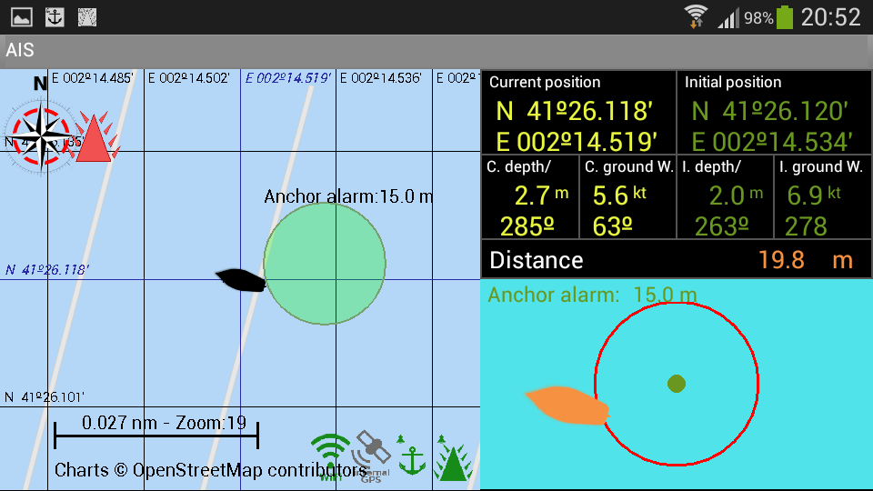
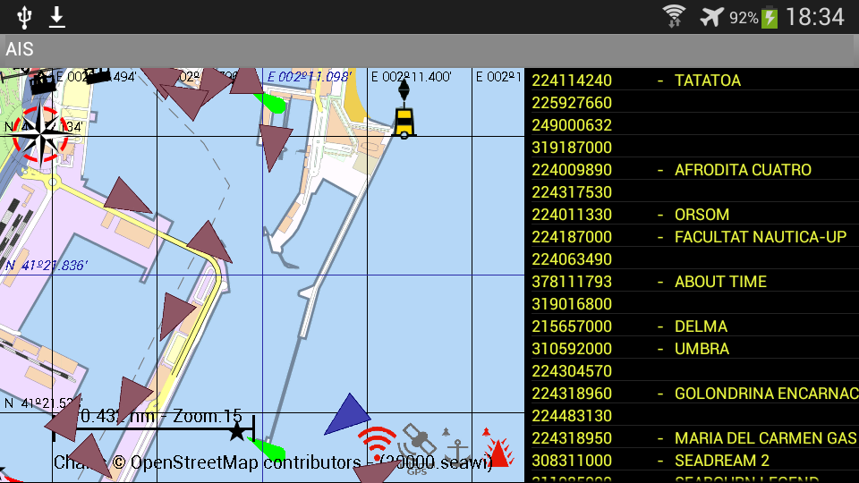
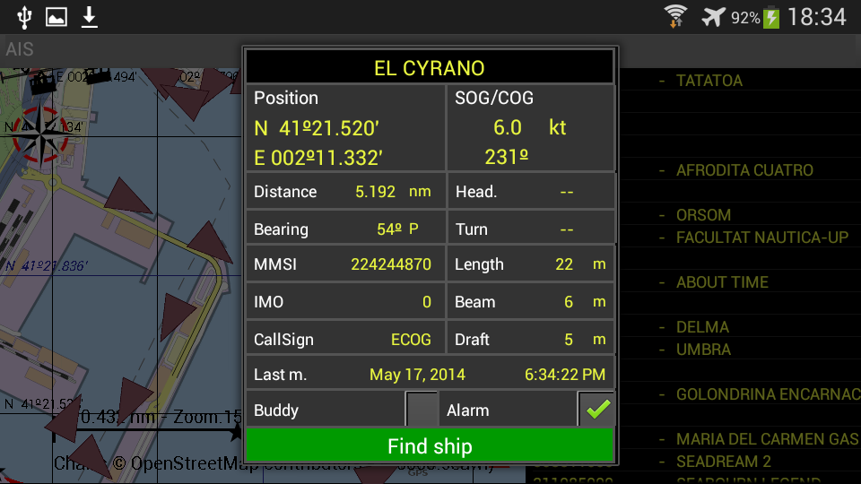
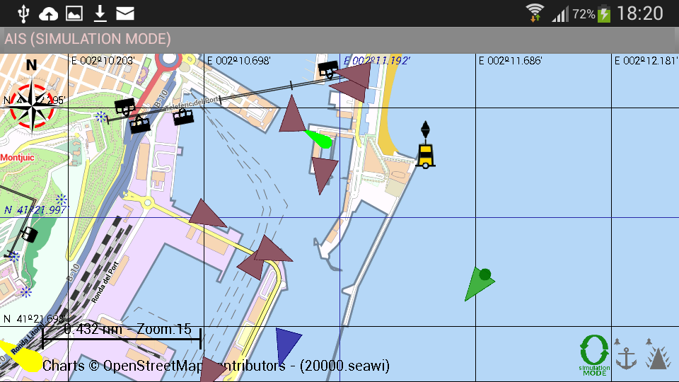
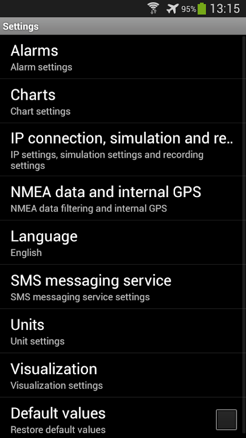
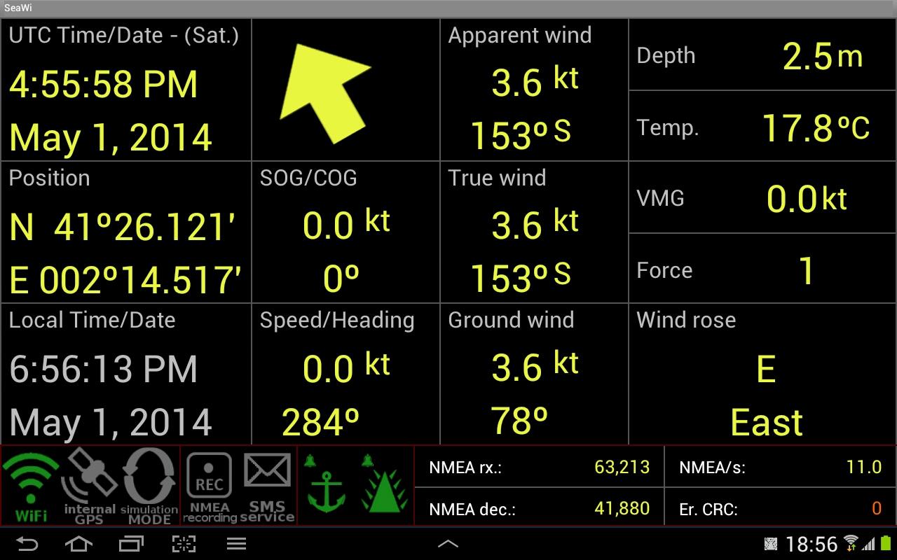
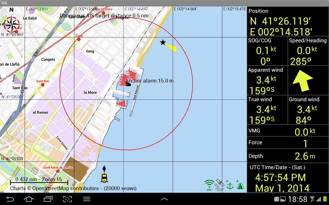
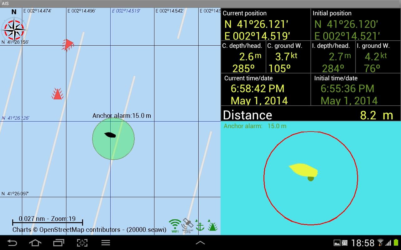
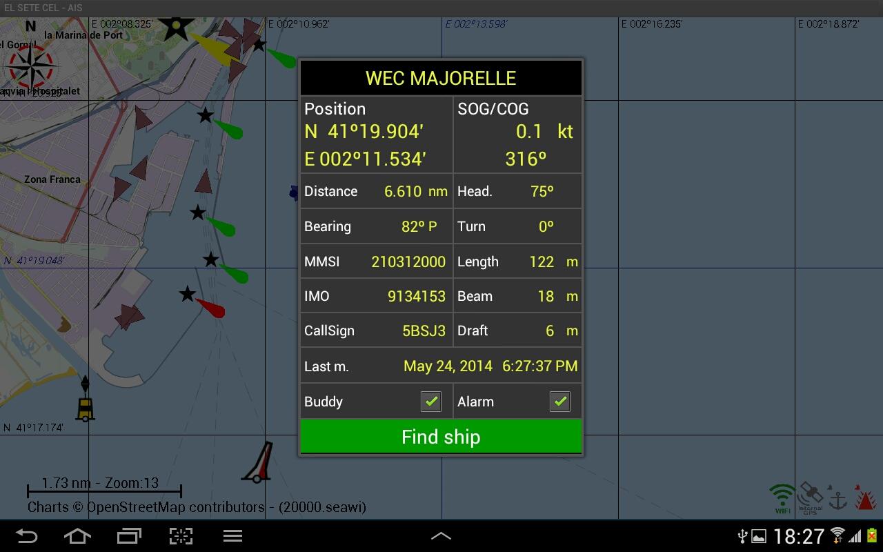
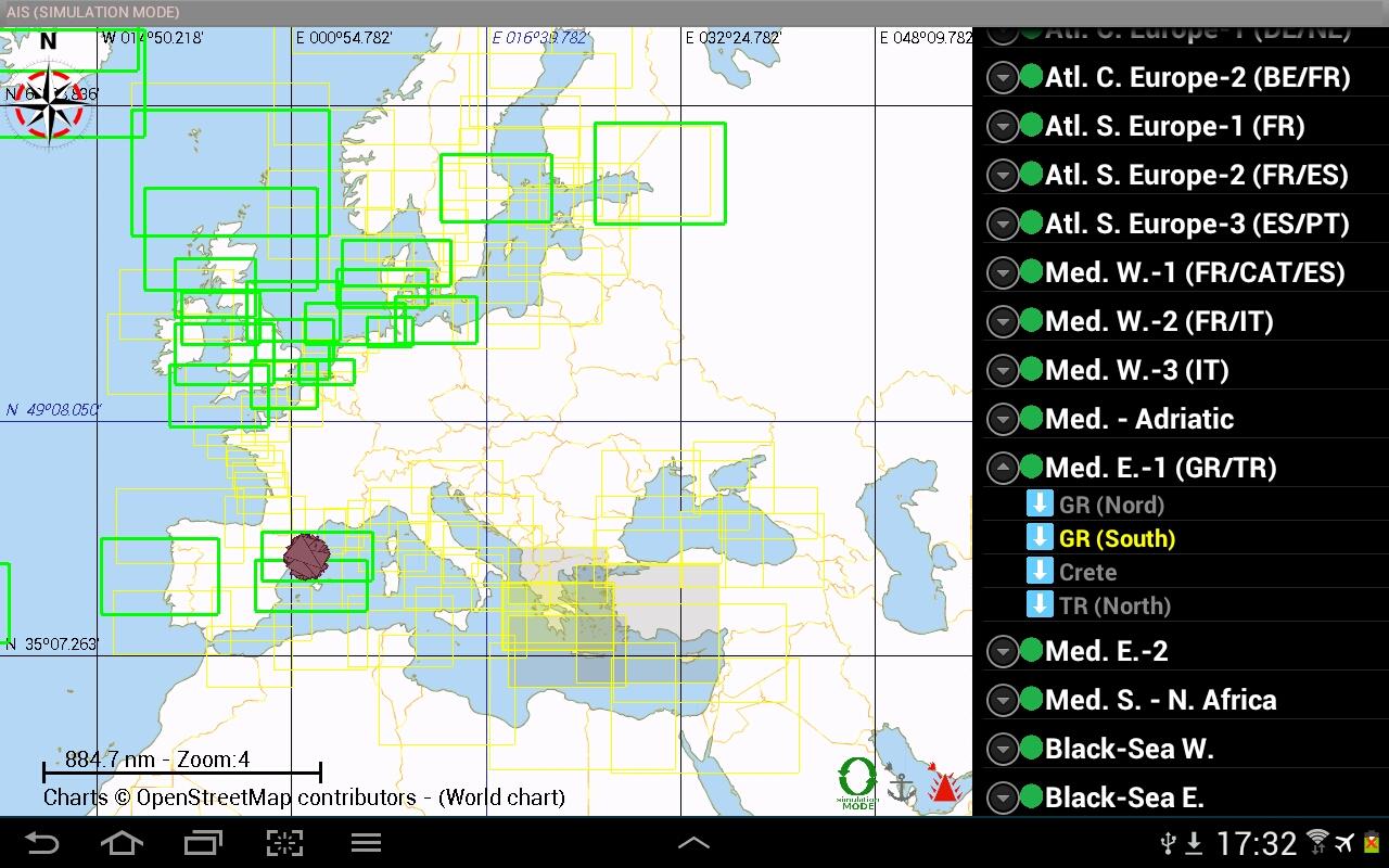
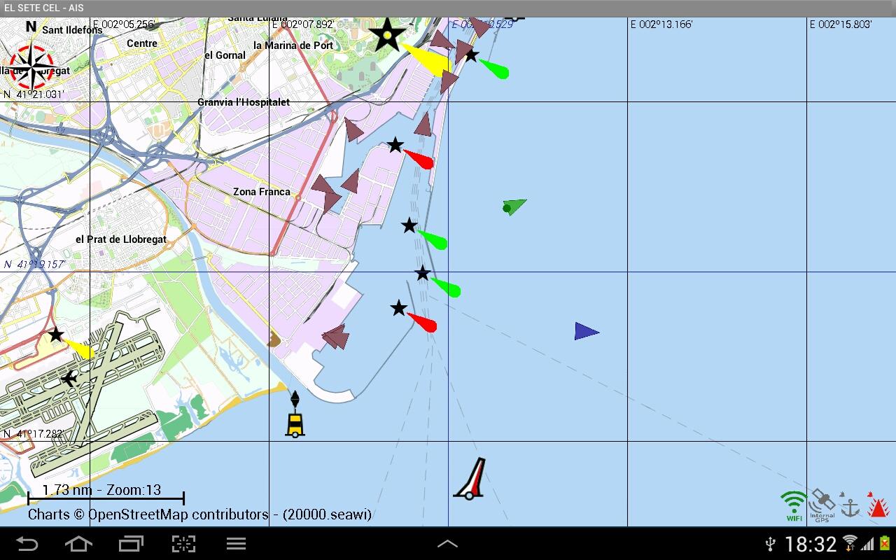
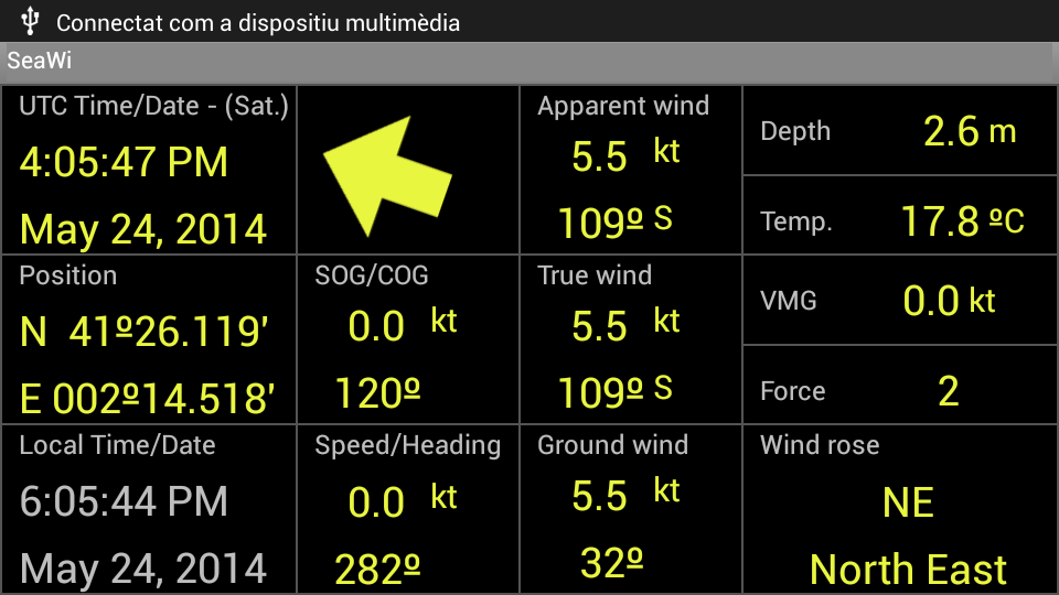
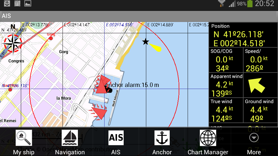
A full Navigation Tool for Android Tablets andPhones and the best Navigation aid Tool for Sailors.Navigation DataVisualize navigation data on your phone or tablet: position,SOG, COG, speed, heading, apparent wind, true wind, ground wind,VMG, Beaufort force, depth, water temperature, UTC time. (A NMEA2000® or a NMEA 0183 WiFi adaptor is required to receive NMEA data.SeaWi decodes NMEA 2000® and NMEA 0183 data received in TPC, UDPUnicast and Multicast packets).You can also use the built-in GPS of your device to showposition, SOG, COG and UTC time.AIS TargetsSeaWi decodes AIS information and allows you to visualize AIStarget information on your phone or tablet: AIS target name andMMSI, AIS target position, AIS target SOG, AIS target COG, distanceand bearing from your vessel, heading, rate of turn, length, beam,draft, IMO, Callsign. SeaWi shows AIS targets on the chart andtriggers alarms for dangerous AIS targets or AIS target lost. (AnAIS receiver and a NMEA 2000® or a 38400 baud NMEA 0183 WiFiadaptor; or a WiFi AIS receiver is required to receive AISinfo).You can select your buddies and keep track of them.AlarmsSeaWi allows you to program multiple alarms: anchor alarms,depth alarms (shallow water alarm, deep water alarm), alarm of lostdata (depth data lost, heading data lost, position data lost,apparent wind data lost) and AIS alarms (dangerous AIS target, lostAIS target).TracksYou can create a track tapping the Create new track button fromthe Track View. The tracks are saved and may be visualized at anytime.You may configure the time period or the distance between trackpoint creation and the number of viewed points at highresolution.You may continue a saved track whenever you need it.WaypointsYou can create a waypoint tapping and holding on a chart position.Once the waypoint dialog appears you can modify the waypointposition and place the waypoint at your vessel’s position or at aposition of your choosing. You can mark the waypoint with sixdifferent symbols: generic waypoint, anchorage waypoint, divingwaypoint, fishing waypoint, dangerous waypoint and MOB waypoint.You may add a photo to your preferred waypoints.Man Over Board (MOB)You can create a Man Over Board waypoint with only one click(menu MOB). Your vessel's position and UTC time and date will beautomatically saved. You can manage the MOB mark as a waypoint fromwaypoints view.SMS ServiceThe SMS Service allows you to receive SMS messages when an alarmis activated. If you are anchored and you are not on board you canprogram alarms (anchor alarm, depth alarm, dangerous AIS targetalarm or lost data alarm) and receive them on your phone. When noton board you can schedule SMS messages at certain intervals of timeand receive navigational data from your vessel on your phone.SeaWi NMEA forwardingYou can forward all navigation and AIS data where you need them.Forward NMEA data to other tablets and phones on your boat. ForwardNMEA data remotely and use SeaWi app to visualize the samenavigational and AIS data as if you where aboard.Log Trip and Simulation ModeYou can record navigational data of your trip and recover themlater to review your trip in Simulation Mode.ChartsOff-line OpenSeaMaps charts of the entire world are available.Currently charts of Europe, North America, Mediterranean Sea, BlackSea, Caribbean, Australia, New Zealand, Pacific and North Africaare available. Charts of the rest of the world will be availablesoon.OpenSeaMap is an open source, worldwide project to create a freenautical chart. In 2009, OpenSeaMap came into life. This mapincludes beacons, buoys and other navigation aids. OpenSeaMap is asubproject of OpenStreetMap and uses its database.
Similar Apps Show More...


AIS Sport Arena 1.3 APK
Application for sport lovers, it is providingall world class football leagues and matches such as EnglishPremier League, Cal-cio series A Italy, La Liga Spain, Ligue 1France, Thail Premier League and all worldwide key footballmatches.You can stay tuned for every movements, real-time reportthroughout 24 hours including match/team statistics, match scheduleand in-depth analysis from leading football experts.Besides football, it's also providing variety of sport news formall over the world such as Golf, tennis, American Football (NFL),Thai Boxing and snooker promptly updated by No.1 Thai sportjournalists of StarSoccer, Sportpool and Siamsport.We guarantee providing more information than anyone else.Real-Time ReportReport every movement throughout football matches.Report Sport circle news from all over the world.Report match statistics every leagues.Report Thai’s and Oversea matches.Report analysis result by experts.Report match summary.

AIS Soccer Live 1.1 APK
AIS Soccer Live is listed as free App so youcan download it and use it for free. We brings you up-to-secondscores from hundreds of soccer games around the world.AIS Soccer Live Freatures:Live soccer scores from leagues and tournament around theworldMore than 100 live soccer games in live scoreLeague tableLine-up on selected matchesMatch facts details informationSet your own refresh periodShake to refresh scoreBandwidth friendly / use minimal data transfersFree


Fashion selfie face changer 1.3 APK
This application has many excellent,marvelous,superb, very good, first-rate, first-class, wonderful,outstanding,exceptional, magnificent, splendid, superlative,matchless,peerless, super, terrific, tremendous, smashing,fantastic,sensational, stellar, ace, fab, A1, cool, awesome andmagical latestfashion dresses. we can not describe there beauty inwords.We are offering you a chance to wear them in free...With this application you can adopt new fashion in just sometouchand FREE...You can also frame border to your work. and save then for shareandfuture watch.You can share your new fashion dress photo and selfie withfriendson sms, mms, facebook, twitter, imo, whatsapp or whateversocialmedia you are using.------------------------------------Main Feature------------------------------------You will get one new frame after every three days thoughpushnotification . its totally free.* So please share this app with friends for help andencourageus.------------------------------------How to Use------------------------------------1) Start application.2) ==> Click on start button for frame your photo==> Click on gallery button for view saved work==> Click on close button to close application. (Please visitourother apps before close app)3) Select frame from list of frames.4) Select photo frame camera or gallery.5) Click cross button for move next.6) Select border frame from list and click cross button formovenext7) Share your work with friends or move to saved work8) If you like our app, Please rate us must. and share app.-----------------------Disclaimer-----------------------This application complies with US Copyright law guidelines of"fairuse". If you feel there is a direct copyright ortrademarkviolation that doesn't follow within the "fair use"guidelines,please contact us directly.


Pancakes and Crepes 2.30 APK
A pancake is a flat cake, often thin,andround, prepared from a starch-based batter that may alsocontaineggs, milk and butter and cooked on a hot surface such as agriddleor frying pan, often with oil or butter. In Britain,pancakes areoften unleavened, and resemble a crêpe. In NorthAmerica, a raisingagent is used (typically baking powder). TheAmerican pancake issimilar to a Scotch pancake[1] or drop scone.Commercially preparedpancake mixes are produced in some countries.They may be served at any time with a variety of toppingsorfillings including jam, fruit, syrup, chocolate chips, or meat.InAmerica, they are typically considered to be a breakfast food.InBritain and the Commonwealth, they are associated withShroveTuesday, commonly known as Pancake Day, when perishableingredientshad to be used up before the fasting period of Lentbegan.Archaeological evidence suggests that pancakes are probablytheearliest and most widespread cereal food eaten inprehistoricsocieties.The pancake's shape and structure variesworldwide. Acrêpe is a thin Breton pancake cooked on one or bothsides in aspecial pan or crepe maker to achieve a lacelike networkof finebubbles. A well-known variation originating in SoutheastEurope isPalačinke, a thin moist pancake fried on both sides andfilled withjam, cheese cream, chocolate, or ground walnuts, butmany otherfillings, both sweet or savoury, can also be used.PancakesÆbleskiver[Apam balikAppamBaghrirBánh cuốnBánh rếBánh xèoBannockBlintzBorlengoBoûkèteBoxtyCachapaChalboribbangChataamariChinese pancakeCholermusCrempogCrêpeCrêpe SuzettePalatschinkenDavid Eyre's pancakeDosaDutch baby pancakeEgg waffleFarinataFicelle picardeFlädleFläskpannkakaFunkasoGaletteGundel pancakeGyabragHirayachiHortobágyi palacsintaHotteokInjeraJeonBindaetteokGamjajeonHwajeonKimchijeonMeat junMemiljeonPajeonJohnnycakeKalathappamKhanom bueangKouign-amannLaobingMasala dosaMemelaMilcaoMoflettaMsemenMunini-imoMurtabakOkonomiyakiPalatschinkePan batiPannekoekPashtiPathiriPesaha AppamPesarattuPloyePoffertjesPotato pancakeQuarkkäulchenRacuchyRava dosaRoti prataScallion pancake – also referred to as spring onion pancakeScovardăSel rotiSerabiSpring pancakeStaffordshire oatcakeSuncakeSwedish pancakeThalipeethTlacoyoToutonUttapamCrêpes are made by pouring a wheat batter onto a frying panorflat circular hot plate, often with a trace of butter orvegetableoil on the pan's surface. The batter is spread evenly overthecooking surface of the pan or plate either by tilting the pan orbydistributing the batter with an offset spatula ortrowel.Theconsistency of the batter cannot be too thick, nor canthe pan betoo hot. In either of these instances, the crêpe could beruinedwith lumpiness or tears. Cooking may take 30 to 60 secondsuntilthe cooked side looks like the surface of the moon, then itisturned over to cook the other side; one can flip it in the airbyswinging the pan (air flipping).Because the outside of the crêpe is more attractive, theyaretypically never served inside out.Sweet crêpes are generally made with wheat flour, whilesavorycrêpes are made with non-wheat flours such as buckwheat.Batterscan also consist of other simple ingredients such as butter,milk,water, eggs, flour, salt, and sugar.Common savoury fillings for crêpes served for lunch or dinnerarecheese, ham, and eggs, ratatouille, mushrooms, artichoke (incertainregions), and various meat products. The fillings arecommonly addedto the center of the crêpe and served with the edgespartiallyfolded over the center.When sweet, they can be eaten as part of breakfast or asadessert. They can be filled and topped with various sweettoppings,often including Nutella spread, preserves, sugar(granulated orpowdered), maple syrup, lemon juice, whipped cream,fruit spreads,custard, and sliced soft fruits or confiture.
Sports Top Show More...

FIFA 15 Ultimate Team 1.7.0 APK
FIFA 15 Ultimate Team by EA SPORTS featuresover 10,000 players from over 500 licensed teams. Plus, over 30real leagues and stadiums! Build a dream squad of footballers andput them to the test. From the English Premier League, La Liga, andMLS, to the German Bundesliga and beyond. Take the thrills with youwherever you are with the most authentic soccer game on GooglePlay.This app offers in-app purchases. You may disable in-apppurchasing using your device settings.** This game has superior graphics and is packed with tons ofreal football leagues, teams, and players. Please make sure youhave at least 1.35GB of free space on your device. **BUILD YOUR ULTIMATE TEAMEarn, trade, and collect superstars like Lionel Messi and EdenHazard to create your own fantasy team. Choose your play style,formation, kits, and more.PLAY IN QUICK SIMULATION MODEPut your management skills to the test with new Quick Simulations.Set up your squad, start the match, and watch it unfold. Make smartsubs, tactical tweaks, and gauge team effort along the way. Yourmatch results depend entirely on your ability to manage playerskills and chemistry – taking authenticity to the next level.OR TAKE IT TO THE PITCH!If you’re new to FIFA on mobile, try out our “Casual Controls”,with elegantly simple buttons like “shoot”, “pass”, or “sprint”.Once you’re feeling comfortable, move on to “Classic Controls”,which let you add either “through passes” or “skill moves” to yourgaming arsenal. Or, you can interact with your team directly,tapping on players to pass the ball and swiping towards the net toshoot. Plus, if you have an external controller – don’t miss thechance to use it on the pitch for the first timeREAL WORLD MATCH UPSPlay your favorite team’s next fixture, plus 3 other majormatch-ups happening around the world – every week!Jump into the action and feel the passion of your favorite sportwith FIFA 15 Ultimate Team!NOTES:Terms of Service: http://www.ea.com/terms-of-servicePrivacy & Cookie Policy: http://www.ea.com/privacy-policyGame EULA: http://tos.ea.com/legalapp/mobileeula/US/en/OTHER/Visit https://help.ea.com/ for assistance orinquiries.EA may retire online features and services after 30 days’ noticeposted on www.ea.com/1/service-updatesImportant Consumer Information: This app: Requires acceptance ofEA’s Privacy & Cookie Policy, TOS and EULA; Includes in-gameadvertising; Collects data through third party ad serving andanalytics technology (See Privacy & Cookie Policy for details);Contains direct links to the internet and social networking sitesintended for an audience over 13.

Real Football 2012 1.6.1d APK
Real Football is back for the new season,bringing football on mobile to a new era! Join the community offans as you create and share content with the Custom Kit Editor.Experience the ultimate football game on smartphone thanks to manymajor improvements and the addition of the most complete andenjoyable community-oriented features.Love football. Share football. Join the community.REPLAY THE GAME YOU JUST WATCHED ON TVEver wish you could control the outcome of a game you watched onTV? Now you can, thanks to Hypergame technology! With just thepress of a button, you can recreate any match-up from the in-gamenews feed and play!STAND OUT ON THE FIELD WITH CUSTOM KITSCreate your own custom team jerseys, shorts and more using adetailed editor, then share it with the rest of the community, orlook for cool designs made by other players and use themyourself.THE BIGGEST, MOST ENJOYABLE FOOTBALL COMMUNITYGet the latest football news thanks to official RSS feeds fromgoal.com, as.com and sports.fr. Send your comments, interact withfriends, upload pictures and videos.FOOTBALL AT ITS FINESTEnjoy smoother and more realistic graphics for both players andstadiums.Over 700 motion-capture-based animations that adjust to players’skills and positions on the field.Smarter moves for your teammates and opponents on the field thanksto an improved AI.New effects and cutscenes during the games for an even more TV-likefootball experience.THE OFFICIAL FIFPRO LICENCEThousands of real players’ names, 350 teams and 14 leaguechampionships to play including England, Spain, France, Germany andSouth America.Online updates of the database will keep your game up to date withthe most recent player transfers and lineup changes.MANY GAME MODES TO ENJOYAccess many different game modes including Exhibition, League andvarious International Cup modes, or practise your skills inTraining mode.You can also take over your favourite team as a manager and lead itto glory, or replay the best games of the past by entering Historymode.Certain apps allow you to purchase virtual items within the appand may contain third party advertisements that may redirect you toa third party site.Privacy Policy : http://www.gameloft.com/privacy-notice/Terms of Use : http://www.gameloft.com/conditions/End User License Agreement : http://www.gameloft.com/eula/

Real Football 2013 1.6.8b APK
The newest edition of the free footballsimulation is back to score another win for the franchise with awhole new set of moves.Take part in the most immersive free football simulation and showthat you are the best on the pitch. Reinforce your team ofchampions by developing your club’s facilities, hiring new staffmembers, dealing with sponsors and more.Join world football champions like our cover athlete, Falcao, onthe pitch. YOU ARE FOOTBALL, YOU ARE REAL FOOTBALL!LEAD YOUR CLUB TO THE TOPTake control of your team on the field during league games or cupgames. Starting with a rookie team, you’ll need to improve yourplayers’ abilities to reach the top league and compete against thebest teams in the world for the championship and the cup.REALISM PUSHED FURTHERFor the first time in Real Football games, see names and portraitsof over 3,000 top Euro and international champions thanks to theofficial FIFPro licence. Updates for the application will keep yourgame up to date with the most recent player transfers and rosterchanges.DEVELOP YOUR CLUBThe best teams in the world have the most modern facilities. It'stime to be a good fantasy manager. Get your players in shape bydeveloping your training grounds to increase your players’physical, technical and tactical skills as a real manager. Earnmore money and attract fans by expanding your stadium, filling itwith shops and signing big-name sponsors.THE MOST IMMERSIVE EXPERIENCESmooth and realistic graphics make every player come to life onyour screen during games. Witness over 700 motion-captureanimations as you take on an improved AI for a TV-like experienceof games with spectacular effects and cutscenes. It's just likewatching real sports!RF13 is a free simulation sport game in which you'll be able towin a league or cup championship, play with world champions, be amanager of a fantasy team, and more. We're bringing you a real,free fantasy simulation and a comprehensive manager game, all inone soccer package.Whether you like soccer simulations, fantasy manager games oryou're simply a fan of the sport, this free game is for you.----Visit our official site at http://www.gameloft.comFollow us on Twitter at http://glft.co/GameloftonTwitter or like us onFacebook at http://facebook.com/Gameloft to get more infoabout all our upcoming titles.Check out our videos and game trailers on http://www.youtube.com/GameloftDiscover our blog at http://glft.co/Gameloft_Official_Blog for theinside scoop on everything Gameloft.Certain apps allow you to purchase virtual items within the appand may contain third party advertisements that may redirect you toa third party site.Privacy Policy : http://www.gameloft.com/privacy-notice/Terms of Use : http://www.gameloft.com/conditions/End User License Agreement : http://www.gameloft.com/eula/

PES CLUB MANAGER APK
The "PES" soccer simulation game has beenplayed by more than 23 million users around the globe.After a major update, the game's cover now features the prestigiousGerman club, BORUSSIA DORTMUND. In addition, the renewal of theentire training mode allows you to enjoy an in-depth playertraining experience.Official players and teams have also been updated to the latest2016/17 winter season.Match commentary is available in 9 different languages (English,Japanese, Mandarin Chinese, Cantonese, etc.) so you can enjoy thistop-quality free-to-play soccer simulation game anytime,anywhere.Test your management skills as the team's manager, owner, andscout. Challenge rival managers around the globe in every aspect ofsoccer![PES Console Game Engine on Mobile Devices]Enjoy playing realistic soccer matches with high-quality 3Dgraphics and analyzing tactics in realtime on an animated 2Dscreen.[Licenses Around the Globe]Official licenses for popular European and Southern Americanteams/leagues are included, with more than 5,000 authenticplayers.[Soccer Simulation Enjoyable for Core Strategists (Basic GameplayAll Free)]Simple controls allow you to easily set tactics during matches. Thetide of matches will change based on your management skill.Experience gripping matches in which you are in totalcontrol.[Try out your Soccer Theory in Player Training Mode]Train players however you want by assigning them to a qualitytrainer and the training venue of your choice. You can competeagainst rivals around the world with the team built under your teamconcept.[User-Driven League]No need to log in at a fixed time. Play each season at your ownpace.[Play the Global Standard of Soccer Games for Free]Winning matches with your own tactics/skills is more satisfying.Win League/Cup rewards to build your team. Bid for players on themarket at the lowest price.We recommend PES CLUB MANAGER if you:・For those who want to construct a great stadium that will beiconic to the club's fans, just like how Borussia Dortmunddid.・Possess a soccer philosophy like FC BARCELONA.・For those who are attracted to clubs like Borussia Dortmund, ateam that contributes to their hometown and is loved by their localfans.・Believe tradition is important for a soccer club.・For those who want to improve their soccer tactics by makingflexible tactical changes during matches like Borussia Dortmund'smanager, Tuchel.・Think a soccer club can become something more than a "club".・Believe "winning in a style" is the ideal victory.・Think soccer is all about tactics.・Want to manage a dream team with your favorite players.・Want to become an owner of a soccer club with a longhistory.・Want to test out new soccer tactics.・Are curious about young soccer stars.・Are curious about mid-season transfers.・Watch national matches.・Root for young players in international tournaments.・Think training young generations is important.・Think philosophy is necessary for strong clubs.・Soccer is your favorite sport.* PES CLUB MANAGER is a free-to-play app. No purchases arerequired. All users can play the entire game free of charge,although purchasing PES Coins can speed up gameplay and help tostrengthen your club faster. In-app purchases can be disabled by“limiting in-app billing” on the device used.Required OS: Android 4.2.0 or later*Operation is not guaranteed on other OSes.Compatible devices:http://www.konami.jp/pescm/jp/sp/info/compatible_model.php5*Please note that support is not offered in response to inquiriesthat involve non-compatible devices.This is an online game only. Users must be connected to theinternet (3G,4G,or Wi-Fi) to play. Internet connection charges maybe incurred separately depending on the user's networkenvironment.Use of this app requires agreement to the app’s Terms of Use,Virtual Currency Terms of Use, and Privacy Policy.License Rights:http://www.konami.jp/pescm/en/sp/info/licenses.php5

Top Eleven 2017 - Be a Soccer Manager 10.9.2 APK
Join over 150 million players worldwide tobecome the best soccer manager with the unbeatable excitement ofTop Eleven! Run your own soccer team - apply Mourinho’s besttactics, use his brilliant line-up or create your own strategies tobeat the competition.Play Top Eleven and experience all the excitement of managing areal soccer clubTop Eleven is the most-played online soccer manager game - Createyour own world-famous soccer team. Test and improve your skillswhile playing against other managers from around the globe. Formyour soccer team in the spirit of the best clubs. Choose officialjerseys and emblems of the best soccer clubs from the PremierLeague, Bundesliga, MLS, the legendary Champions League and manymore soccer leagues.Begin your journey to become a soccer manager today!Join forces with friends, talk tactics, compare with other soccerteams and beat the competition in this one-of-a-kind freemultiplayer game! Organize the best training sessions, level-up andwin bonuses to encourage your team's progress. Pick your topplayers to create the best team possible. Motivate your players onand off the pitch and start scoring goals! Top Eleven brings youthe most socially engaging soccer manager experience as youchallenge real people worldwide or collaborate with them using ournew associations social feature!★Bid for players as you follow the live soccer transfermarket★Build your own winning strategies★Follow your team’s performance in live matches★Develop a stadium with all surrounding facilities★Challenge other soccer managers in competition andfriendlies★Win Cups and qualify to play in the Champions League★Create your very own soccer association and invite friends tojoin in as you compete against others!Top Eleven is translated into 30 different languages!---For any issues or suggestions regarding the game, simply contact usat https://nordeus.helpshift.comOur Player Support team offers support in 10 languages.

ICC Pro Cricket 2015 2.0.23 APK
ICC Pro Cricket 2015Play the Official Game of the ICC Cricket World Cup 2015.This game features over 150 official players from the 14 teams ofthe ICC Cricket World Cup 2015.****Nominated by the FICCI BAF AWARDS 2016****_________________________________________________________"The game is optimized for Quad core ARM 7 Devices with 2GB of RAM,Android 4.2 and above. There might be visual and functionaldiscrepancies on lower devices."Support id: [email protected] with us on: https://www.facebook.com/ProCricket2015__________________________________________________________Do you want a taste of Real Cricket?One of the most detailed and realistic cricket simulationexperiences of its kind, “ICC Pro Cricket 2015” is a gamers delight– equipped with 2 game play cameras and over 25 in-game cameraangles, the cricket fever never stops.Bored of playing the usual fantasy league, county cricket and testmatch games?Don’t stick to the old cricketing format; move on to the T20 styleof big shots and big plays.Taking inspiration from ICC Champions Trophy 2016 we have a new andimproved game for our fans.ICC Pro Cricket 2015 is a real Cricket 3d simulation game where youcan get the excitement of an ODI match on your mobile screen.Play different modes, get your favorite players and make sure youbeat your opponent to ashesBuild your dream team with players like Chris Gayle, Virat Kohli,Steve Smith, AB de Villiers and Rohit Sharma to name a few.You might be a WWE or a Fifa fan, you might even love Basketball,but this will surely make you feel like you’re playing the WorldCricket Championship.Features:• First ever cricket game with real simulation and cardmanagement.• Modes: ICC Cricket World Cup Tournament, World Tour Mode (Dreamteam) and Quick Match Mode• All 14 participating ICC Cricket World Cup 2015 Countries withthe original Player names.• Motion captured animation to get the real cricketingexperience.• Intuitive batting Controls & Innovative Bowling controls.Control the speed, line and length.• Complete your daily objectives to earn gold which will help youstrengthen your squad.IMPORTANT CONSUMER INFORMATION:ICC Pro Cricket 2015 respects your privacy and does not store anypersonal informationWe do require a few additional Permissions to make your gamingexperience better:• We need access to photos media and files to install thegame• Contacts to access Google play• Phone for game pause on receiving calls• Location for relevant advertisement servingPRIVACY POLICY:To read our complete privacy policy please visit the below URLhttp://www.disney.in/privacy-policy.htmlhttp://www.disney.in/addendum-to-global-privacy-policyICC Pro Cricket 2015 and Indiagames Cricket Card Battle areproduced by Indiagames Ltd., an affiliate of the Walt DisneyCompany.About Disney India’s Interactive Business:Disney India’s Interactive business is a hub for creation anddistribution of high-quality digital content reaching out tomillions of users in India. It develops and delivers multi-platformgames and digital products including apps for multi-brands underDisney India - Indiagames, UTV, Disney, Marvel, and Disney.Pixarand distributes the content via mobile operators and various OEMapp stores in India and globally.Copyrights:The ICC symbol, name style, typeface, colors and logo and those ofthe ICC Cricket World Cup 2015 (any or all of which are referred toas the “ICC Identity”) are trade marks and (as appropriate)copyright works of ICC Development (International) Limited (“IDI”)© 2001-2015. All rights in the ICC Identity remain the property ofand are reserved to IDI. All proprietary names, logos and marksrelating to the ICC Identity, the ICC Cricket World Cup 2015 andthe participating teams that appear in this game remain theproperty of their respective owners and are used herein underlicense.

Dream League Soccer 2.07 APK
Top 10 Sports Game in Italy, Singapore,Belgium & Turkey!Soccer as we know it has changed! Dream League Soccer is YOURchance to build THE best team on the planet. Recruit new Players,upgrade your Stadium, and train your team as you march towardsglory, on your road to Soccer Super Stardom!Download Dream League Soccer for FREE now!* Includes Tablet Support! ******************************************BUILD YOUR TEAMUse our in depth transfer system to build the team of your choice!Sign players using coins or even spot a bargain in the freetransfer market! Develop a team of up to 32 players for theultimate experience, including the ability the create your ownplayers!INTELLIGENT AI, RAPID GAMEPLAY & SHARP VISUALSSmart defensive and attacking player AI form a challenging andaddictive experience. With intuitive controls & excellentvisuals, Dream League Soccer is the perfect Soccer package whichcaptures the true essence of your favourite sport.COMPETE ACROSS 4 LEAGUES IN A BID TO RISE TO THE TOP!Got the skills to gain promotion into the Elite Division? Or ifthat’s not enough, it doesn’t just end there...Friendly matches,the Global Challenge cup and a few extra prestigious competitionsawait the very best Dream Teams out there!DEVELOP YOUR PLAYERS TO REACH THEIR FULL POTENTIALTrain your squad members in our unique player development program.Increase Ball Skills, Fitness, Distribution and much more!MEET YOUR TARGETSStrive every match to achieve your board’s season and matchobjectives, also keep your fans happy with our very own fan ratingsystem!GET INVOLVED!Watch matches come to life with over 60 unique celebrations,realistic cameras and ultra smooth animations.CRAMMED FULL OF ACHIEVEMENTS!Unlock challenging achievements to keep you engaged for hours, eachone giving you in-game currency to help build the ultimate dreamteam!*****************************************Exclusive soundtrack provided by Charly Coombes & the NewBreed, Dance à la Plage, We Outspoken & Secret Rivals.We hope you enjoy playing Dream League Soccer; this titlewouldn’t be possible without valued fan feedback.PLEASE NOTE: This game is free to play, but additional contentand in-game items may be purchased for real money.Coins can be earned during gameplay or gained by watchingvideos, but can also be bought in packs ranging from $1.99 -$54.99.This app contains third party advertising. Advertising isdisabled if you purchase in game currency from the shop.VISIT US: firsttouchgames.comLIKE US: facebook.com/dreamleaguesoccerFOLLOW US: twitter.com/firsttouchgamesWATCH US: youtube.com/firsttouchgames

Star Sports Live Cricket Score 4.8 APK
The Star Sports App is the official free livevideo streaming app with live match coverage spanning across sevensports (Cricket, Football, Kabaddi, Tennis, Formula1, Badminton,Hockey).Nobody covers live matches like we do!Streaming Now: Vivo Indian Premier League 2016 (IPL), EnglishPremier League 2016, Bundesliga 2016, Formula1 2016.What do you get with Star Sports:- Match Video Streaming, absolutely free, across seven sports- Live cricket & football scores with complete match centrecoverage- Cricket's finest video scorecard, fastest score & ball byball updates- Match schedules, fixtures & results, standings & pointstally for all tournaments- The official live match streaming app for the Pro KabaddiLeague- Great collection of videos: full match replays, match highlights,in-match clips, match preview & review, batsmen & bowlersperformance, goals, etc.We truly believe the only way to improve ourselves is bylistening to sports fans like you. Please send us your suggestionsand feedback at [email protected]. You can also followwww.starsports.com on your browser.Please note:Videos will only work on 3G and Wifi connectivity.