


Description
App Information Balades en Bourgogne
- App NameBalades en Bourgogne
- Package Namecom.voxinzebox.baladesenbourgogne
- UpdatedMay 15, 2023
- File SizeUndefined
- Requires AndroidAndroid 5.0
- Version2.0.3
- DeveloperCôte-d'Or Tourisme
- Installs-
- PriceFree
- Category
- Developer
- Google Play Link
Côte-d'Or Tourisme Show More...

Bourgogne Rando Vignes 1.3 APK
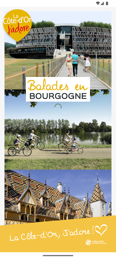
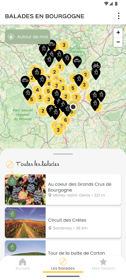
Sur les chemins de L’UNESCOLe vignoble des côtes de Nuits et de Beaune contribue depuis prèsde deux mille ans à la réputation des vins de Bourgogne et continued'être aujourd'hui l'une des références mondiales pour les grandsvins rouges. A l’image des vins qu’il produit, grands crus,premiers crus et même appellations génériques, ce territoire uniquedéveloppe des valeurs fortes d’ouverture, de découverte et derencontre. Un patrimoine et un site culturel unique façonné parl’homme depuis plus de 20 siècles !Avec cette nouvelle application mobile découvrez les climats depuisles chemins de randonnée qui les traversent. Autour de la Butte deCorton et à Santenay…pour commencer. Bourgogne Rando Vignes vouspermet de vous promener à travers les vignes grâce à sacartographie géolocalisée. Des audio guides culturels, desexplications sur les climats, des indications directionnelles ettouristiques et une option de réalité augmentée vous accompagnenttout au long de la balade afin de conjuguer au mieux nature etculture. Les circuits de randonnée sont téléchargés au préalableafin de naviguer avec une technologie embarquée et éviter ainsitout problème de connexion.Avant d’enfiler vos chaussures de marche, n’hésitez pas à consulterles slides « découvrez » pour vous familiariser avec cette notionde Climats aujourd’hui sur le devant de la scène avec soninscription au patrimoine mondial de l’UNESCO. Car aujourd’hui,voilà un modèle de viticulture qui rayonne dans le monde entier,tout comme le nom de certains crus, inclassables comme celui de laRomanée-Conti.Mais la Côte-d’Or, cœur de la Bourgogne, ce sont aussi :- Des spécialités qui font la réputation gastronomique de ladestination, comme les escargots de Bourgogne, la moutarde deDijon, le pain d’épices, les Anis de Flavigny, le cassis et toutesles tables de chefs inspirés,- Un patrimoine d’exception comme Dijon, capitale des ducs deBourgogne, Beaune, capitale des grands vins de Bourgogne,Châteauneuf-en-Auxois et Flavigny-sur-Ozerain, Plus Beaux Villagesde France, Semur-en-Auxois la médiévale, Montbard et sonnaturaliste Buffon, les abbayes cisterciennes de Fontenay etCîteaux, le muséoParc d’Alésia et la fameuse bataille entre Césaret Vercingétorix, Châtillon-sur-Seine et le célèbre vase deVix…- Une nature accueillante pour pratiquer en toute quiétude denombreuses activités de plein air : rando, vélo, tourisme fluvial,baignade, golf, escalade…Que vous soyez plutôt branché vin, gastronomie, patrimoine ounature, la Côte-d’Or est faite pour vous.On the paths ofUNESCOThe vineyards of the Côtes de Nuits and Beaune for nearly twothousand years contributes to the reputation of Burgundy wines andcontinues to be today a world reference for red wines. Like thewines it produces great wines, first growths and even genericnames, this unique territory develops strong values of openness,discovery and encounter. Heritage and unique cultural site shapedby man for over 20 centuries!With this new mobile application learn climates since the footpathsthat cross. Around the Butte de Corton and Santenay ... to start.Rando Burgundy Vineyards allows you to walk through the vineyardswith its geolocation mapping. Cultural guides audio explanations ofclimates, directional and tourist information and an optionalaugmented reality accompany you along for the ride to combine thebest of nature and culture. The hiking trails are downloaded priorto navigate with a board and avoid any problem of connectiontechnology.Before putting on your walking shoes, do not hesitate to consultthe slides "learn" to familiarize yourself with the concept ofclimates today on the front of the stage with his inclusion in theWorld Heritage of UNESCO. For now, here is a model of viticulturethat radiates around the world, just like the name of some raw,unclassifiable such as Romanée-Conti.But the Gold Coast, the heart of Burgundy, it is also:- Specialties that are the gastronomic reputation of thedestination, such as Burgundy snails, Dijon mustard, gingerbread,Anis de Flavigny, blackcurrant and all tables inspired chefs,- An exceptional heritage as Dijon, capital of the dukes ofBurgundy, Beaune, capital of Burgundy wines, Chateauneuf-en-Auxoisand Flavigny-sur-Ozerain, Most Beautiful Villages of France,Semur-en-Auxois medieval, Montbard and naturalist Buffon Cistercianabbeys of Fontenay and Cistercian Museopark Alesia and the famousbattle between Caesar and Vercingetorix, Châtillon-sur-Seine andthe famous vase Vix ...- A friendly practice in peace for many outdoor activities innature: hiking, biking, river tourism, swimming, golf, climbing...Whether you are rather trendy wine, gastronomy, heritage or nature,Côte-d'Or is for you.

Similar Apps Show More...


SityTrail France - hiking GPS 12.7.0.2 APK
SityTrail is a GPS for all of your outdooractivities anywhere in France.Here are its main functions:★ IGN FRANCE TOPOGRAPHIC MAPS IN YOUR POCKETAll the topographic maps you need to discover France, Corsica andOverseas departments and territories on foot, cycling, horseriding, or by car, motorbike or quad.Subscription charge: The application can be accessed forfree for a week’s trial. You may then take out a subscription for€24.99 per year, all-inclusive.Tourism and discoveryDiscover the new 1:25 000 IGN map ideal to (re)discover an area onfoot, bicycle, horseback or car. The series includes coverage ofmainland France, Corsica and Overseas departments and territoriesrepresenting all relevant information for outdoor activities:roads, trails, streams, tourist sites, shelters, rest houses,buildings, religious buildings, ...The Grandes RandonnéesThe GR ®, maintained by the French Federation of Ramblers, are alsodisplayed: 60,000 km of hiking trails! Also shown on the maps arethe PR ® (petites randonnées) shorter walks for a day.★ MAPS AND YOUR WALKS AVAILABLE IN OFFLINE MODEThe download tool lets you get the most out of your maps and routeson the ground without any internet connection.There is an alarm when you stray from the route being followed. Nomore need to continuously check your smartphone, this alarm systemwill stop you getting lost or having to turn back onyourself.Automatic activation of points of interest and text to speechsynthesis.An elevation profile that enables the visualisation of inclines andof any difficulties along the route.★ RECORD YOUR ROUTES WITH PHOTOSRecord your walks in real time on the ground, and create points ofinterest with your own photos and commentary.Display showing distance covered, time taken, average speed, GPSaltitude, inclines (+/-), and many other useful indicators forwalkers and mountain bikers.Estimate of distance and time remaining based on your averagespeed.Elevation profile for the current recording.★ CREATE AND SHARE YOUR WALKSWith our online editor, create your own walking projects using aninternet navigator on your PC/MAC and then accessing them directlyfrom your mobile to experience them on the ground.Go further. Transform your favourite walks into real multimediaguides with text, photos, video links, and share them with theSityTrail community.Access too to thousands of walking circuits from other members andlet yourself be guided!★ TOURIST ATTRACTIONS AND WEATHER SERVICEGet plenty of localised tourist information: articlesWikipédia, accommodation, restaurants, and various servicessuch as chemists and banks.Save your favourite places so you can consult them during yourtrip.Check on the five-day weather forecast for any location on the mapto help you organise your stay.★ ADDITIONAL FUNCTIONSEasily create points of interest, such as the location of your car,your hotel, or a restaurant.In the event of any problems, the SOS function enables you to sendyour GPS coordinates to your contacts.Geocachers can use the compass to find their way to ageocache.★ ANDROID WEAR SMARTWATCH- Route and GPS position visualisation.- Indication of distance covered and remaining.- Arrow display indicating the direction to be taken.- Alarm when you stray from the route.We wish you lots of fun with SityTrail France.Application Manual:http://www.sitytrail.com/lang-en/manuals_trail.htmlFor any questions or suggestions:http://www.sitytrail.com/lang-en/support_trail.html- - -Some functions need an internet connection.The prolonged use of GPS can reduce battery levels.


Topo GPS France 7.2.0 APK
Makes from your phone or tablet a complete GPS device with thedetailed topographic map of France. Viewed maps will be stored onyour device so that Topo GPS can also be used without an internetconnection. Why should you buy an expensive GPS device if you caninstall Topo GPS? Topo GPS contains all functions of a regular GPSdevice for less money, has a much more detailed map, and is moreconvenient to operate. The accuracy of the position determinationis in favorable conditions about 5 m. The price of the detailedtopographic map is 0,99 € for four sections of 4 by 4 km. You getlifetime access to purchased sections including future map updates.You can easily select the sections you need on an overview map. Youget a discount if you buy a large section at once. Purchases aremade available on all devices that share the same Google Playaccount. Ideal for walking, hiking, cycling, mountainbiking,horse-riding, geocaching, trail running and other outdooractivities. Also suited for outdoor professionals. Map * Completetopographic map of France, scale 1:25,000 (SCAN25 from IGN), newestedition. * Very detailed maps, with buildings, cultivation, allroads including the smallest forest trails, contour lines, andcharacteristic elements in the landscape. * Future updates of themap are included for free. * The map can be zoomed and moved. * Allmaps of a certain region can be made offline accessible using themap download screen. * Percentage of map that is offline accessibleis indicated on the top left of the map. * Map tiles can be storedon external storage, like for example an SD-card. Intuitiveinterface * Clear menu with most important functions. * Differentdashboard panels with distance, time, speed, altitude andcoordinates. * Clear manual at www.topo-gps.com. Routes * Recordingof routes, with pause and restart possibility. * Planning of routesvia route points. * Importing routes in gpx and zipped gpx format.* Editing routes. * Sharing routes. * Free access to routecollection Topo GPS. * Searching routes with filters. * Routes canbe organized into folders. * Maps of a route can be made offlineaccessible. Waypoints * Adding waypoints by pressing on map. *Adding waypoints through address or coordinates. * Supportedcoordinate systems: WGS84 decimal, WGS84 degree minutes (seconds),UTM, MGRS and Lambert93. * Importing waypoints in gpx and zippedgpx format. * Sharing waypoints. * Editing waypoints. * Photos canbe added to waypoints. * Searching waypoints with filters. *Waypoints can be organized into folders. Your location * Locationand movement direction indicated by arrowed marker. * Displayablein WGS84 decimal, WGS84 degree minutes (seconds), UTM, MGRS andLambert 93 coordinates. * Sharing and saving as waypoint. In apppurchases * Topographic maps of Belgium, Denmark, Finland, France,Germany, Great Britain, Netherlands, Norway, New Zealand andSweden. * OpenStreetMap world map. If you are recording a route,the GPS will run in the background. Continued use of GPS running inthe background can dramatically decrease battery life. Rdzl, thecompany behind Topo GPS, does not obtain in any way the location ofthe user of Topo GPS. Rdzl does not obtain your routes andwaypoints, unless you share a route with Topo GPS. Rdzl does notregister which map tiles you have downloaded. We sell our product,not our user data.


Chamonix APK
Chamonix Tourist Office, the Compagnie duMont-Blanc and la Chamoniarde (mountain safety and rescueorganization) provide all practical information about Chamonix on asingle and free mobile app : " Chamonix, official mobileapplication of the Chamonix-Mont-Blanc valley ! "Lifts, hiking ideas, mountain bike itineraries, webcams,directory and map of the town, transport, mountain conditions, hutinformation and you can also reload your pass !Continue use of GPS running in the background can decreasebattery level.

 1.0.30")
IGN maps (E-walk plugin) 1.0.30 APK
E-WALK PLUGIN This app in an E-walk plugin (a plugin is an appthatadds features to another app). You need E-walk to use thisplugin:https://play.google.com/store/apps/details?id=com.at.ewalk.free.The plugin adds to E-walk the ability to use the French IGNmaps,and IGNrando'. WARNING: these features mostly cover Franceonly.IGN MAPS The IGN maps are highly detailed and cover thetotality offrench territory. Some maps are only available atcertain zoomlevels. They are the same as the ones used on theGéoportailwebsite (http://www.geoportail.gouv.fr). The IGN mapsplugin addsto E-walk 8 base maps : • ortho images: a highresolution satelliteimagery (zoom levels 2 - 19) • scan: a scan ofpaper IGN maps (zoomlevels 2 - 18) • scan express (classic): a scanof paper IGN mapsoften updated but with less details (zoom levels 6- 18) • scanexpress (standard): a scan of paper IGN maps oftenupdated but withless details, with another style (zoom levels 6 -18) • ICAO maps:International Civil Aviation Organisation maps(zoom levels 6 - 11)• administratives limits: administrativeslimits map (zoom levels 6- 10) • elevation map: digital terrainmodel (zoom levels 6 - 14) •army staff map (1820-1866): historicalmap from 18th century (zoomlevels 6 - 15) And 8 overlay maps: •cadastral parcels (black): mapof numerical cadastral information(zoom levels 2 - 20) • cadastralparcels (white): map of numericalcadastral information (zoomlevels 2 - 20) • cadastral parcels(orange): map of numericalcadastral information (zoom levels 2 -20) • administrative limits:map of administrative limits (zoomlevels 6 - 18) • buildings: mapof constructions (zoom levels 12 -18) • geographical names: mapshowing names of cities, towns, etc...(zoom levels 12 - 18) •Histolitt coastline: map showing the limitbetween land and marinearea (zoom levels 6 - 18) • hydrography: mapof lakes, reservoirs,rivers, creeks, etc... (zoom levels 6 - 18)LICENCES The pluginallows to see the maps through two licences:Discovery licence(free), and Adventure licence (5.99$USD / month or14.99$USD /year). The Discovery licence is limited by a monthlyquota sharedbetween all the users. Once the quota is exceeded, themaps can'tbe displayed until the next month. With the Adventurelicence, youcan also download the maps beforehand on your device,in order touse them without any internet access. IGNrando’IGNrando'(https://ignrando.fr) is a website provided by the IGN,allowingyou to visualize treks and points of interest among thetens ofthousands available. You can also add and share yours. Thosetreksand points of interest are mostly available in France only.WithE-walk, you can synchronize the treks and points of interestthatyou like on your device. Thereby, they will be availableanywhere,and you'll no longer need an internet access to see them.


