


Description
App Information BackPackTrack II
- App NameBackPackTrack II
- Package Nameeu.faircode.backpacktrack2
- UpdatedApril 26, 2016
- File Size4.5M
- Requires AndroidAndroid 4.1 and up
- Version1.35
- DeveloperMarcel Bokhorst
- Installs1,000 - 5,000
- PriceFree
- CategoryTravel & Local
- Developer
- Google Play Link
BackPackTrack II Version History
Select BackPackTrack II Version :-
BackPackTrack II 1.35 APK File
Publish Date: 2017 /3/25Requires Android: Android 4.1+ (Jelly Bean, API: 16)File Size: 4.5 MBTested on: Android 6.0 (Marshmallow, API: 23)File Sha1: 4c7e761a8722bdf0ab8313cf94ccbb5319f62b79 -
BackPackTrack II 1.26 APK File
Publish Date: 2015 /9/12Requires Android: Android 4.1+ (Jelly Bean, API: 16)File Size: 4.3 MBTested on: Android 6.0 (Marshmallow, API: 23)File Sha1: 2306b707bbb4a9562886e799be1637b1a3289ec9
Marcel Bokhorst Show More...

BackPackTrack II 1.35 APK
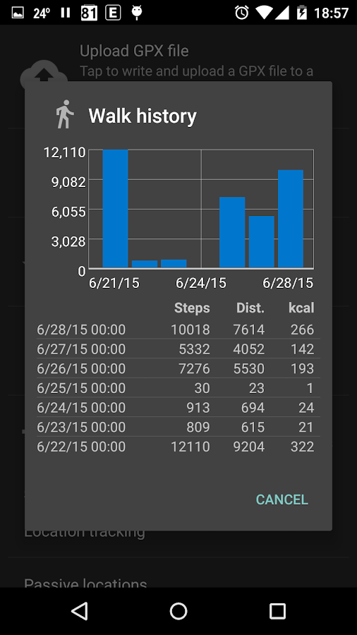
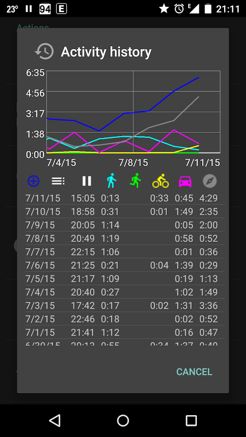
BackPackTrack II is an open source utilityapplication meant to continuously record your location, withoutdraining your battery and without requiring an internet connection.The GPS will be switched on every 3 minutes for a maximum of 60seconds (both configurable) to acquire a location, but only if youare moving. If there is not at least one satellite visible after 30seconds (configurable), the GPS will be turned off. When the GPScannot get a fix, a network location will be used as backup.BackPackTrack II will also passively use locations requested byother applications, for example mapping applications. Passivelocations will be recorded if the bearing changes by more than 30degrees or if the altitude changes by more than 20 meter (bothconfigurable).Locations will be filtered based on distance from your lastlocation and based on location accuracy. The default is to filterlocations within 100 meter of the last location and locations withan accuracy of worse than 100 meter.The altitude of GPS locations will be corrected using the EGM96model, which can make a significant difference in some areas.From the status bar notification you can make an extratrackpoint or a new waypoint. Waypoints will be automaticallyreverse geocoded if there is an internet connection, otherwise thiscan be done later using the waypoint editor.You can export your location history as a GPX or KML file forvisualization in another application. You could use OsmAnd orGoogle Earth for this purpose.You can upload your location history to a WordPress weblog usinga small WordPress plugin. You could use the Google Maps GPX Viewerplugin for visualization.If you want to see the status of the GPS, you could use theapplication GPS Status & Toolbox.As a bonus BackPackTrack includes:- an activity history, so you can see when you were doingwhat- a step counter which doesn't count false steps, because activityrecognition will be used to count steps only while you are walking(your device needs to have a hardware step counter for this towork)- tabular and graphical actual and historical weather information,including weather notification and rain warning- hourly and daily weather forecasting for the last or a selectedlocation- search for Wikipedia articles around waypoints- search for geonames around waypoints- fetch elevation data from GoogleBackPackTrack II is a complete rewrite of BackPackTrack, thefirst Android application I wrote in 2011.See here for more information:https://github.com/M66B/BackPackTrackII/You can ask questions here:http://forum.xda-developers.com/android/apps-games/app-backpacktrack-ii-t3123682

FairEmail, privacy first email 1.2028 APK
FairEmail is easy to set up and works with virtually all emailproviders, including Gmail, Outlook and Yahoo! FairEmail might befor you if you value your privacy. FairEmail is an email clientonly, so you need to bring your own email address. FairEmail doesnot support non-standard protocols, like Microsoft Exchange WebServices and Microsoft ActiveSync. Almost all features are free touse, but to maintain and support the app in the long term, notevery feature can be for free. See below for a list of profeatures. A lot of effort has gone into this app, which wasdeveloped to help you protect your privacy. If you have a questionor problem, there is always support at [email protected]. Mainfeatures * Fully featured * 100 % open source * Privacy oriented *Unlimited accounts * Unlimited email addresses * Unified inbox(optionally accounts or folders) * Conversation threading * Two waysynchronization * Push notifications * Offline storage andoperations * Common text style options (size, color, lists, etc) *Battery friendly * Low data usage * Small (~20 MB) * Materialdesign (including dark/black theme) * Maintained and supported Thisapp is deliberately minimalistic by design, so you can concentrateon reading and writing messages. This app starts a foregroundservice with a low priority status bar notification to make sureyou'll never miss new emails. Privacy features *Encryption/decryption supported (OpenPGP, S/MIME) * Reformatmessages to prevent phishing * Confirm showing images to preventtracking * Confirm opening links to prevent tracking and phishing *Attempt to recognize and disable tracking images * Warning ifmessages could not be authenticated Simple * Quick setup * Easynavigation * No bells and whistles * No distracting "eye candy"Secure * No data storage on third party servers * Using openstandards (IMAP, POP3, SMTP, OpenPGP, S/MIME, etc) * Safe messageview (styling, scripting and unsafe HTML removed) * Confirm openinglinks, images and attachments * No special permissions required *No advertisements * No analytics and no tracking (error reportingvia Bugsnag is opt-in) * No Google backup * No Firebase CloudMessaging * FairEmail is an original work, not a fork or a cloneEfficient * Fast and lightweight * IMAP IDLE (push messages)supported * Built with latest development tools and libraries Profeatures All pro features are convenience or advanced features. *Account/identity/folder colors * Colored stars * Notificationsettings (sounds) per account/folder/sender (requires Android 8Oreo) * Configurable notification actions * Snooze messages * Sendmessages after selected time * Synchronization scheduling * Replytemplates * Accept/decline calendar invitations * Add message tocalendar * Filter rules * Automatic message classification * Searchindexing, search on server * S/MIME sign/encrypt * Biometric/PINauthentication * Message list widget * Export settings Support Ifyou have a question or problem, please check here first:https://github.com/M66B/open-source-email/blob/master/FAQ.md If youcannot find what you are looking for, please contact me [email protected] and I will try to help you.

Fine Geotag 1.21 APK
Automatically geotag photos with a real-timelocation right after they are taken.The camera application mostly uses the last known location,which could be old and miles away from your current position.FineGeotag will try to acquire an accurate location in real-timeand update the Exif location tags of the photos taken.FineGeotag will try to use the GPS and/or the network location,depending on which location providers are enabled in the Androidsettings.Optionally a popup will be shown with a thumbnail of the photoand the reverse geocoded address.More information / source code / support: https://github.com/M66B/FineGeotag
Similar Apps Show More...

Maps & GPS Navigation OsmAnd+ APK
OsmAnd+ (OSM Automated Navigation Directions)is a map and navigation application with access to the free,worldwide, and high-quality OpenStreetMap (OSM) data.Enjoy voice and optical navigation, viewing POIs (points ofinterest), creating and managing GPX tracks, using contour linesvisualization and altitude info, a choice between driving, cycling,pedestrian modes, OSM editing and much more.OsmAnd+ is the paid application version. By buying it, you supportthe project, fund the development of new features, and receive thelatest updates.Some of the main features:Navigation• Works online (fast) or offline (no roaming charges when you areabroad)• Turn-by-turn voice guidance (recorded and synthesizedvoices)• Optional lane guidance, street name display, and estimated timeof arrival• Supports intermediate points on your itinerary• Automatic re-routing whenever you deviate from the route• Search for places by address, by type (e.g.: restaurant, hotel,gas station, museum), or by geographical coordinatesMap Viewing• Display your position and orientation• Optionally align the picture according to compass or yourdirection of motion• Save your most important places as Favorites• Display POIs (point of interests) around you• Display specialized online tiles, satellite view (from Bing),different overlays like touring/navigation GPX tracks andadditional layers with customizable transparency• Optionally display place names in English, local, or phoneticspellingOnly this week 50% OFFUse OSM and Wikipedia Data• High-quality information from the best collaborative projects ofthe world• OSM data available per country or region• Wikipedia POIs, great for sightseeing• Unlimited free downloads, directly from the app• Compact offline vector maps updated at least once a month• Selection between complete region data and just road network(Example: All of Japan is 700 MB or 200 MB for the road networkonly)Safety Features• Optional automated day/night view switching• Optional speed limit display, with reminder if you exceedit• Optional speed-dependent zooming• Share your location so that your friends can find youBicycle and Pedestrian Features• Viewing foot, hiking, and bike paths, great for outdooractivities• Special routing and display modes for bike and pedestrian• Optional public transport stops (bus, tram, train) including linenames• Optional trip recording to local GPX file or online service• Optional speed and altitude display• Display of contour lines and hill-shading (via additionalplugin)Directly Contribute to OSM• Report data bugs• Upload GPX tracks to OSM directly from the app• Add POIs and directly upload them to OSM (or later ifoffline)• Optional trip recording also in background mode (while device isin sleep mode)OsmAnd is open-source and actively being developed. Everyone cancontribute to the application by reporting bugs, improvingtranslations or coding new features. The project is in a livelystate of continuous improvement by all these forms of developer anduser interaction. The project progress also relies on financialcontributions to fund coding and testing of newfunctionalities.Approximate map coverage and quality:• Western Europe: ****• Eastern Europe: ***• Russia: ***• North America: ***• South America: **• Asia: **• Japan & Korea: ***• Middle East: **• Africa: **• Antarctica: *Most countries around the globe available as downloads!From Afghanistan to Zimbabwe, from Australia to the USA. Argentina,Brazil, Canada, France, Germany, Mexico, UK, Spain, ...

Contour lines plugin — OsmAnd APK
This plugin provides contour lines andhillshade which can be displayed in OsmAnd's offline maps.* To download hillshade and contour lines map: Manage map files →choose the country you need → Hillshade/Contour Lines* To enable hillshade layer online maps plugin should be enabledand hillshade should be selected as underlay layer* Latest update: download functionality is fixed (New OsmAnd isrequired) *The global data (between 70 degrees north and 70 degrees south) isbased on measurements by SRTM (Shuttle Radar Topography Mission)and ASTER (Advanced Spaceborne Thermal Emission and ReflectionRadiometer), an imaging instrument onboard Terra, the flagshipsatellite of NASA's Earth Observing System. ASTER is a cooperativeeffort between NASA, Japan's Ministry of Economy, Trade andIndustry (METI), and Japan Space Systems (J-spacesystems).
")
GPS Status PRO - (legacy key) APK
NOTE: The main (free) app now supports in-apppayments to purchase a PRO license. Please purchase a licensefrom the side navigation menu of GPS Status & Toolbox. Toencourage the purchase the in-app license is 50% off compared tothis price. This app is left here only for users who havepreviously purchased the key app so they can still download it,when they need to reinstall the app.This is a plugin for 'GPS Status & Toolbox' that will removethe in-app advertisements from the program and add several PRO onlyfeatures. Please consider supporting the development.PRO features:- show/store/edit multiple waypoints and use them on the Radar fornavigation.- pressure, rotation, temperature, humidity values (if supported bythe device)- removed adsIf you do not have 'GPS Status & Toolbox' installed, visit the'More by MobiWIA' section and install it from there.If you like GPS Status & Toolbox, please leave a review hereand share your (hopefully) good experiences.Thank you for your support.NOTE: To avoid polluting your launcher with redundant icons, startGPS Status using the icon for the plugin (PRO). It will start GPSStatus and also will disable itself, so on next phone reboot theicon will disappear.-- MobiWIA - a cooperation with Andrs Studio --

Parking Plugin — OsmAnd 1.0 APK
OsmAnd Parking Plugin is a reminder for yourparking position.This is an additive plugin to the navigation app OsmAnd.The plugin offers two functions:- time independent reminder (only a marker on the map).- time limited reminder with alarm upon time expiration (includesalso a marker on the map).To place a Parking reminder on the map:1.Tap and hold on the map until a text bubble pops up.2.Tap on the text bubble and choose Parking reminder from themenu.3.Set the type of reminder you wish.Activating/Deactivating OsmAnd Parking Plugin,can be done inOsmand>Settings>Plugin Manager.


ElevMaps 1.7.23 APK
ElevMaps is a powerful GPS tool with a simple and easyuserinterface. ElevMaps is a 3D / 2D map viewer for your hikingtrips,but not only ; ElevMaps is perfect also for mountainbike,paraglide, and many outdoors activities ... The 3D mapsarerendered in OpenGL by combining map tile from various sourceswithelevation data. The maps can be displayed like classic map(Northup) or with automatic rotation (GPS orientation andCompassorientation) ElevMaps is also a great map navigation GPStool ...You'll be never lost with it ! Current features : .Viewonline/offline maps in 3D and 2D. . Download maps areas forofflineuse. . View offline maps downloaded with Mobile AtlasCreator(MOBAC) The atlas format is OSMAND tiles storage. . ViewMapsforgemaps/OpenAndroMap maps with different render themes. .Perfect mapsview with zoom level commands IN/OUT and screen fingersgesturesintegration. . Import and view OziExplorer maps. . Downloadandattach elevations for current downloaded maps. . Use elevationdatain SRTM3 format (stored in device and perfect for big maps) .Trackrecording in KML/GPX format. . Track builder for easytripspreparation in KML/GPX format. . Track player with hiking modeorflight mode 3D in air (KML/GPX format) . Import/Export tracksinKML/GPX format. . Statistics window (altitudes, speed,distance...) . Search a place on the map (internet needed) . Andmorefeatures coming soon ...


GPS Device Toolbox 1.0.5 APK
This app allows you to download log data fromexternal GPS Receiver/Logger (like Holux M-241,TranSystem 747 ...)via bluetooth, similar to BT747 and ezTour on PC.Main features:* Download log data.* Delete log data.* Restart device.* View logging settings and GPS status.* Record raw NMEA sentenses.*** This app does NOT work with cellphone/tablet's bulit-in GPS.Certain external GPS device is required! ***
Travel & Local Top Show More...

Flightradar24 - Flight Tracker 6.7.1 APK
Turn your phone or tablet into anairtrafficradar and see planes around the world move in real-timeonadetailed map. Or point your Android device at a plane in theskytofind out where it’s going and more. Discover today whymillionsarealready using Flightradar24 - Flight Tracker.Features that have helped make Flightradar24 - FlightTrackerthe#1 selling app in 100+ countries and the #1 Travel appin140+countries (United States, France, United Kingdom, Germanyandmore)include:* Watch planes move in real-time on detailed map* Identify planes flying overhead by simply pointing yourdeviceatthe sky (the augmented reality view requiresrearcamera,accelerometer & magnetic sensor)* Experience what the pilot of a an aircraft sees in real-timeandin3D* Tap on a plane for comprehensive flight andaircraftinformationsuch as route, estimated time of arrival, actualtime ofdeparture,aircraft type, speed, altitude, andhigh-resolutionpicture* Easy to search for individual flights using flightnumber,airport,or airline* Easy to filter by airline, aircraft, altitude,speed,andmore* Easy to set bookmarks to enable quick navigation toareasofinterest* Turn the device into the arrivals and departures board ofanymajorairport and get real-time status updates for flightspluscurrentairport weather conditions (in-app purchase)* Realistic aircraft symbols (in-app purchase)* Set up custom alerts based on airline, aircraft type,flightnumberor registration (in-app purchase)HOW IT WORKSMost aircraft are equipped with so called ADS-Btranspondersthattransmit positional data. Flightradar24 has arapidlygrowingnetwork of several thousand ground stations aroundthe worldtoreceive this data that then shows up as aircraft movingon a mapinthe app. In an expanding number of regions Flightradar24,withthehelp of multilateration, is able to calculate thepositionsofaircraft that don’t have ADS-B transponders.Traditional radar data is also used in the app thanks toadirectfeed from the US Federal Aviation Administration (FAA).http://www.flightradar24.com/how-it-works***IMPORTANT NOTICES***Minimum required screen resolution is 320x480px.If you are only interested in tracking air traffic inaspecificregion, we suggest that you checkFlightradar24.comBEFOREpurchasing the app. Flightradar24 providesunrivaledpositionalaircraft data coverage around the world butthere areareas wherewe don’t have coverage.Overview of coverage as of January 2016:* Europe: close to 100%* North America: 100% of US and Canada via slightlydelayedradardata. Real-time coverage for most of US, Canada andMexicoforADS-B equipped aircraft* South America: Substantial coverage in mostcountriesincludingArgentina, Bolivia, Brazil, Chile, Colombia,EcuadorandVenezuela.* Asia: Substantial coverage in most major AsiancountriesincludingJapan, India, Indonesia, South Korea, Thailand,UAE,Malaysia,Taiwan and many other countries. Rapidlyexpandingcoverage inChina* Oceania: Nearly complete coverage in AustraliaandNewZealand* Africa: Substantial coverage in Africa with coverageexpandingallthe time.Find out how you can help:http://www.flightradar24.com/increase-coverageCoverage is subject to change at any time.HELP & SUPPORTforum.flightradar24.com/threads/89-Important-Read-this-before-you-ask-questionsflightradar24.com/contact-us.DISCLAIMERThe use of this app is strictly limited toentertainmentpurposes.This specifically excludes activities thatmight endangeryourselfor the lives of others. Under nocircumstances will thedeveloperof this app be held responsible forincidents resultingfrom theuse of the data or its interpretation orits use contraryto thisagreement. We reserve the right toanonymously track andreport auser's activity inside of app.

MOFA KSA 2.5.5 APK
يعد تطبيق وزارة الخارجيةالسعوديةللأجهزةالذكيةهو أحد قنوات الوصول لخدمات الوزارة والتي منخلالهيمكن تنفيذمجموعةمن الخدمات التي تستهدف شرائح مختلفة منالمستفيدين(أفراد،أعمال،وحكومة) كما يتم تحديث التطبيق بشكل دوريبمجموعة منالخدماتالجديدةوالتحسينات التي من شانها رفع مستوى الرضالدىالمستفيدين منخدماتالوزارة.تنفيذ وتطوير التطبيق:تم تطوير التطبيق من قبل الإدارةالعامةلتقنيةالمعلوماتوالاتصالاتالدعم الفني والاقتراحات:يرجى تعبئة الاستبيان الموجود ضمن مشاركاتإلكترونية-استبيانتطبيقالأجهزة الذكية أو مراسلتناعلىالبريدالإلكتروني[email protected]

MakeMyTrip Hotel Extranet 5.0.0 APK
Hoteliers, this one is foryou!MakeMyTrippresents the exclusive Hotel Extranet mobileappspecially designedto keep your hotel details up-to-date.With this app, you can:• Have access to day-wise / calendar view of your hotelrates&inventory• Update your hotel rates & inventory day-wise as well asforalonger period of time• Update ALL your tariffs’ inventory in just 2 steps• Track your important business metrics(likeCheck-InsToday/Tomorrow, Room Night Check-Ins in next 30 days,SoldOut innext 90 days etc.)• Keep a track of all your bookings & also takenecessaryactionslike Confirm a booking, Mark Check-In/No Show fora Pay AtHotelbooking• View complete details of a booking (including the voucher)• Call a Pay At Hotel customer with a single tap• Manage your Hotel Promotions in quick & easy waywithanability to create new promotions• Keep a track of your Payments• View help video tutorials to understand the utilityofourapp• Push Notifications to help you with Sold Out days &summaryofyour BookingsHotel Extranet will set you free from long chain mailsandphonecalls. No matter where you are, you can keep yourhoteldetailsfresh within a few easy steps.Also, there is lot more to come, which will make yourlifeeveneasier!

hottel - Hotel Booking 4.1.20 APK
Everyday hotels give us last-minutediscountsontheir available rooms.Best prices are guaranteed.Hotels are hand-picked to meet your expectation.10 seconds to book a roomPay less enjoy more.8:00 - 24:00 every night we are ready.Contact [email protected]