


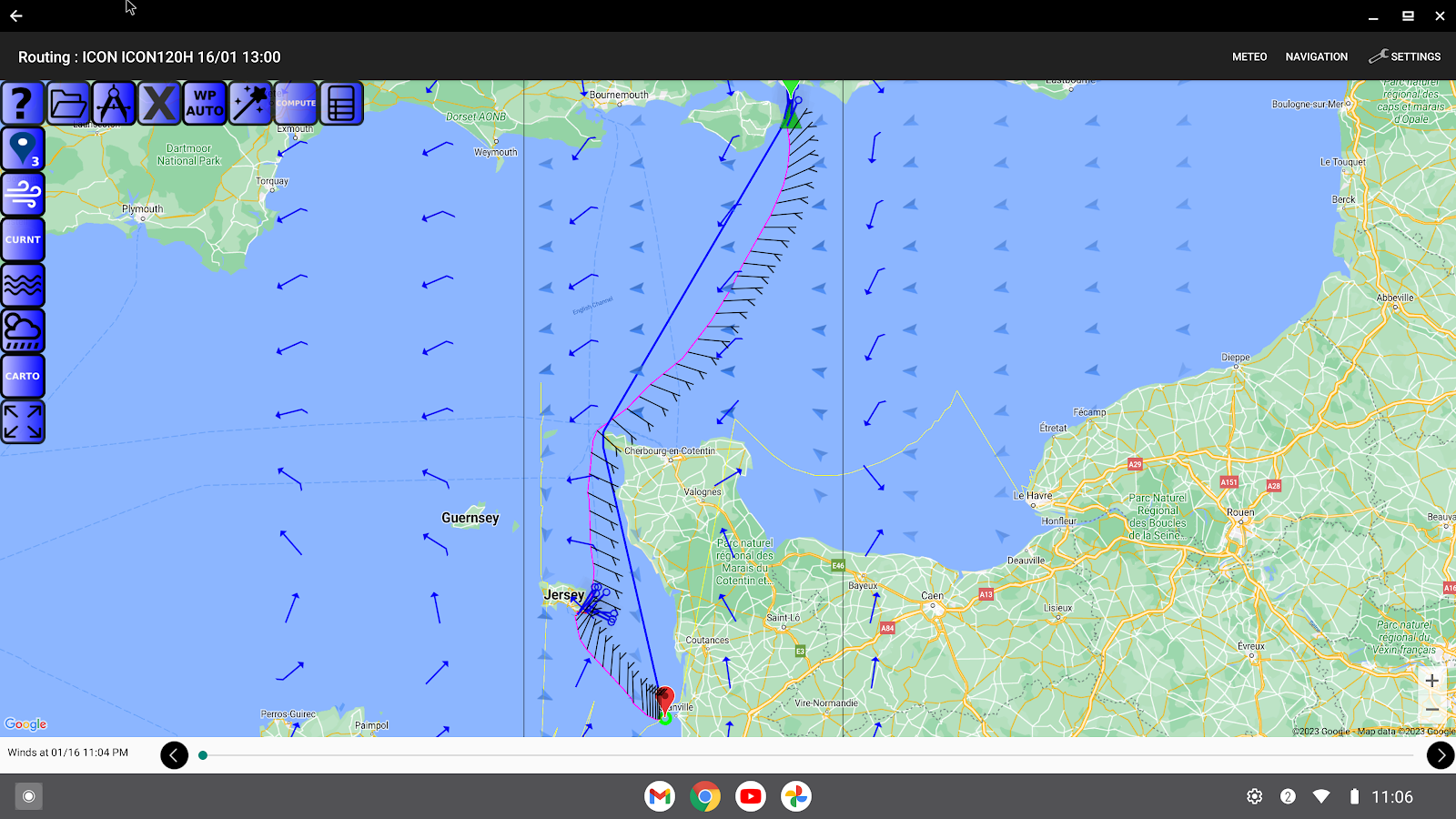


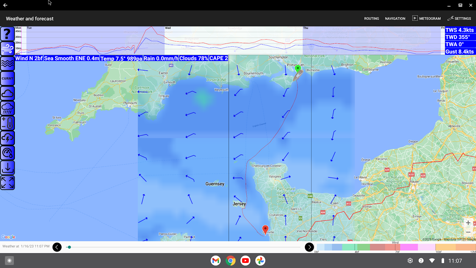

Description
App Information Avalon Offshore
- App NameAvalon Offshore
- Package Namecom.avalon.avalonoffshore.app
- UpdatedJun 23, 2023
- File SizeUndefined
- Requires AndroidAndroid 5.0
- Version6.2.3
- DeveloperAvalon Navigation Systems
- Installs-
- PriceFree
- Category
- DeveloperPod 2 The Old Station House 15A Main Street Blackrock Co.Dublin Dublin A94 T8P8
- Google Play Link

Similar Apps Show More...


Vaarkaart Friese Meren 2.11 APK
The perfect chart for sailing on the Frisianlakes. This chart is made for boat renters, skippers and crew ofsail boats, motor boats and barges. Also recommended for canoes andfishers.AreaFrom Stavoren to Grouw, with the following lakes:: Heegermeer,Fluessen, Morra, Oudegaster Brekken, Zwarte and Witte Brekken,Sneekermeer, Koevorden, Tjeukermeer, Langweerderwielen, andPikmeer/Wijde Ee.This is a detailed chart with a scale 1,3m/pixel. This comesdown to about 1 : 5000 on the screen.Depth viewWith clear depth view from the Friese Meren Project in well coloreddepth areas on the lakes and depth numbers along the water ways.Developed by Stentec in cooperation with the province Fryslân basedon the most recent depth measurements.WaypointsThe included database contains 2345 waypoints divided in 13 groups.The 145 marinas show phone numbers and websites. Other groups areamong others bouyage, mooring spots, campings and gas stations.The accurate positioned bouyage contains the so called‘slobbers’. These mark the protected bird area from 1 October to 1May. Outside this period these are replaced by yellow regattabuoys.Marrekrite 2014 natural mooring places are also included in thechart. You can easily see if camping is allowed (CAMP), if acontainer is present (CONT) or if you can moor (WAL).The bridges and locks along the water ways are shown with heightand width so you can easily plan your route. The many aquaducts arealso shown. Most bridges are operated daily from 1 May to 1November from 9h-19h. In June, July and August even until 20h.

AirMate 1.7.1 APK
Airmate is a free and easy to use application for pilots, providinghelp for flight planning and navigation, and including many socialsharing features. Thanks to Airmate flight planning tools, you willget instant access to airport data and aviation maps worldwide andup to date weather and NOTAMs. IFR and VFR airport plates arefreely available in US (FAA charts), all Europe, and more than 200other countries. Many of them are georeferenced and could beoverlaid on the aviation chart. A powerful Plate Manager allows todownload in advance all airport plates in a country, they could beeasily printed and viewed. During the flight, the moving map willdisplay the aircraft location along the route, show airports andaeronautical data details. A profile view is available to displayterrain elevation across the route. Airmate includes a worldwideaeronautical database updated free of charge with airports,navigation beacons, waypoints, airways, regulated and restrictedareas. Topographic maps and elevation data for most countries maybe downloaded free of charge, as well as additional aviation mapoverlays such US Sectionals. Airmate will also record your flightsand allow to replay them later or export the flight path in gpxformat. A Satellite map display mode in flight planning or replaymode allows to familiarize with significant landmarks. Airmate willsave planned and flown flights, user waypoints and user aircraftsin the cloud and sync them between your devices. Airmate bringsnumerous social features to the community. Pilots may leaveratings, tips and comments to share their experience with fellowpilots, and report fuel prices and landing fees. They could findfriends, instructors, flight schools, aviation events and aircraftto rent near their home airport or any visited airport.


