


Description
App Information Air VFR GPS- International Sta
- App NameAir VFR GPS- International Sta
- Package Namecom.aviation.sixpacklog
- UpdatedApr 7, 2020
- File SizeUndefined
- Requires AndroidAndroid 4.0
- Version2.5
- DeveloperGiPSi Navigation
- Installs10K+
- PriceFree
- CategoryMaps & Navigation
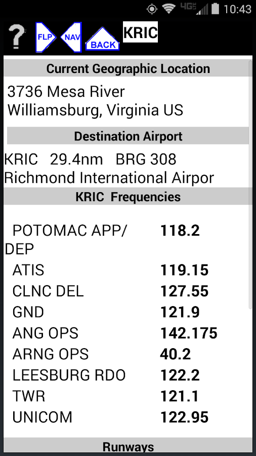
- DeveloperGiPSi Navigation 3736 Mesa River Williamsburg, VA 23188
- Google Play Link
GiPSi Navigation Show More...

Diabetic Insulin LogAlert Paid 1.26 APK
This App is a paid version of the FreeDiabetic Insulin Log/Alert. It's purpose is to fund furtherdevelopment on thisand other Medical Apps.The new Summary Screen is a tremendous aid for proper sizing ofmedication. A quick look and you knowexactly what your current medications are doing plus a comparisonof recent medication levels.The DMM is specifically for Diabetics and Caregivers that arededicated to tight and safe control who use MDI or Flexible InsulinTherapy (FIT).This APP makes it easy to quickly store and check times andamounts of insulin. For MDI users, it is an easy way to keep trackhelping to avoid an unpleasant low.The APP makes it so easy to keep track of medication times andamounts. For example, just start the APP and use the large customkeyboard to enter amount (1+ pushes) and select the type of insulin(1). Then press EXIT. That is all you have to do. This avoidswasted time compared to other medication logging APPs.The APP creates a record plus optionally reminds, via popup orandroid alert, sound, or vibration when the medication onsets,peaks, or other selected time occurs.When you want to check your active insulin, simply start theAPP, select Active Insulin and you see a list of all functioninginsulin plus a weeks history of average BG and number of unitsused.This APP was designed by a Type 1 diabetic to keep track ofGlucose and Med times dates and averages. This can save timeoverall with information at your fingertips giving you instantstatus on how your therapy is working.It is especially valuable for athletes with irregular exerciseschedules. Aerobic one day and Anaerobic the next who want to usealarms to know when to check glucose. Even more so to people whoparticipate in anaerobic exercise. This app will do this with theleast keystrokes.In addition to the visual and audio reminder alerts a historicalrecord or log, is stored in the smartphone. The log, in ExcelFormat, can be exported via email for analysis or read off thePhone Smart Card. On a desktop Excel may be used to analyze andplot the data recorded.

Trial VFR GPS MM Nav + Plan V1.80 APK
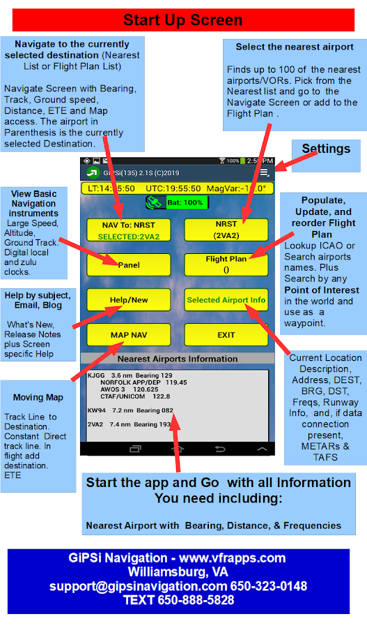
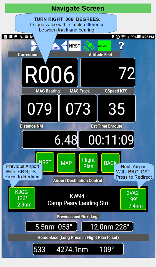
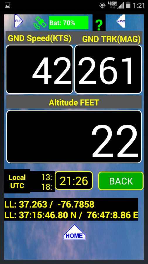
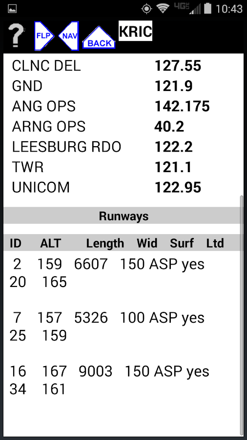
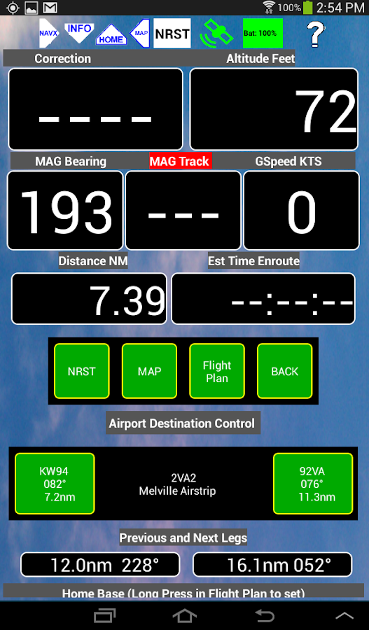
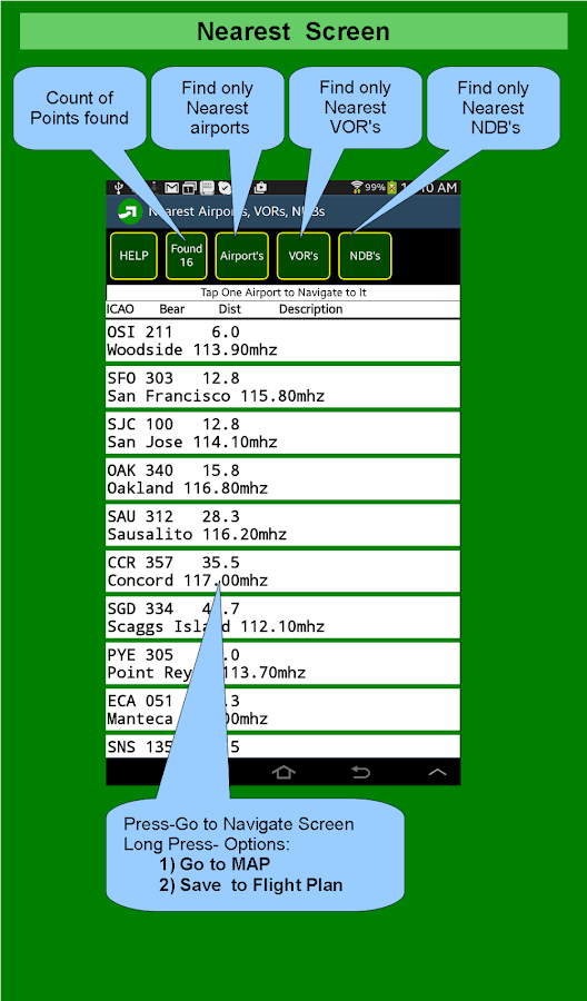
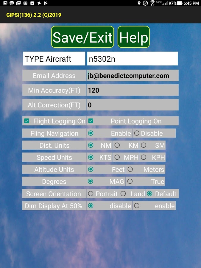
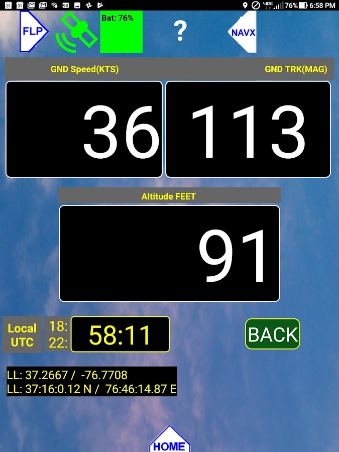
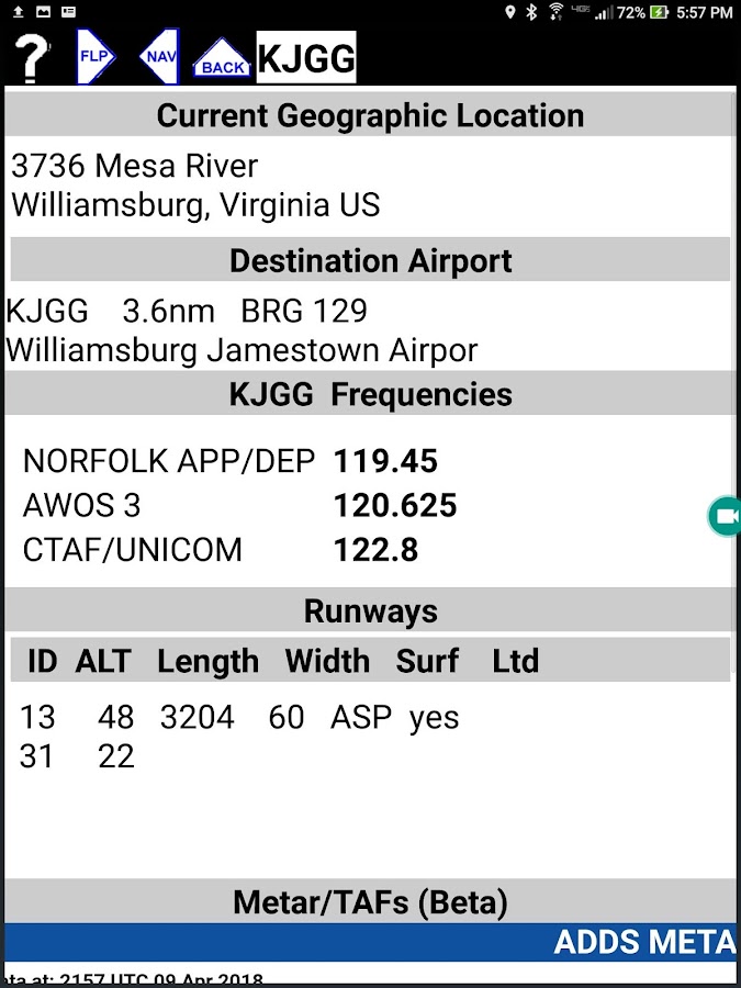
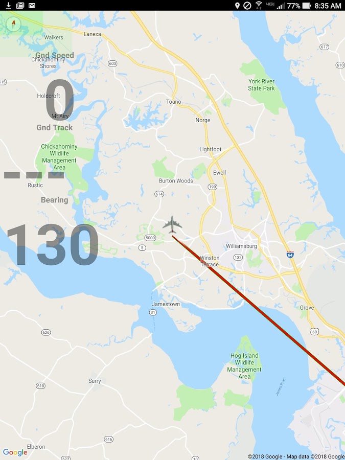
This is a Free 30 day Trial of the VFR GPSAirplane Navigation Paid App. This fully self contained tool willguide you to any airport, Vor, or Point of Interest in the world.No downloads, no subscriptions, no ads, updates are free.The Moving Map Screen requires a temporary data connection forautomatic downloading.This GPS based system is a quick and extremely simple full Guidanceand Navigation tool for pilots to enjoy the view from the skywithout wasting precious flying time with complicated navigationinstruments. Searches and easily provides guidance to any airport,Radio VOR, or Point of Interest(any LAT/LON combination) in theworld.The Navigation screen works well on either a smartphone or tabletcomputers. If you fly multiple planes, you will have one portablefamiliar navigation tool that you can rely upon.It only takes 5 to 10 minutes to learn how to get to any airport,anywhere in the world. Search airport descriptions, identifiers, ornearest lists. Pick a spot on the map and with a single pressinsert it into your flight plan and immediately see the bearing,bearing line, and distance to that location from your current GPSlocation.Search for Airports, VOR's, and NDB's. Search for "nearest airportsto any airport in your flight plan" capability from the flight planscreen.Unique Where Screen. Designed to aid the pilot by providinginformation to aid location identification to ATC.You can export, import and edit your flight plan on your device orsave and edit multiple versions on any computer. This is easilydone to any cloud service, such as Google Drive.EASY TO USE:Press NEAREST for the nearest 50-100 runways, press (select) theairport you want, and follow the bearing or track on the map,verbally if you wish. This App shows a single prompt (R)ight or(L)eft and the number of degrees, Eg. "L005" for turn left 5degrees. Easy. It also shows Ground Track, Bearing, Ground Speed,Altitude, Distance to Airport and Estimated Time of Arrival atcurrent speed.Press MAP and you have a moving map with "Press and Go." With themap visible, press any place on the map and the Lat/Lon from thatlocation will be stored in the destination list.Choose to immediately navigate to that location. In this case thenavigation bearing line will be redrawn. Edit the name of thelocation in the Flight Plan screen at any timeIf you check the MAP screenshot on this page, you can see that tonavigate to your destination, just turn to the plane until thetrack (black with pointer) line is coincident with the RED Bearingline.. The bearing line can be re draw to start from your currentlocation anytime.Any airport in our world database can be found by ICAO or a word orphrase from the Description. For example, "paris" would return 25runways to select from.VIEW YOUR FLIGHT.There is a point logging feature. In the air, every 30 seconds aLat/Lon point is stored along with Altitude and Ground Speed. ThePoint Log can be emailed to your computer and opened with Excel orother compatible program. A hyper link is included to see thatlocation on Google Maps.There is an automatic Log Book feature that automatically recordstime in the air. The Log Book stores your flight hours as well asyour Type Aircraft and Tail Number. The Log Book can be started irstopped manually.If you have a question or issue, email us as soon as possible. Wewant to be available for support when you need it.AUTOMATIC LOGBOOKThe Automatic Logbook feature uses a ground speed value greaterthan 30 KTS to determine when you rotate and a speed value lessthan 5 KTS to determine when you have landed.For further information, please email us [email protected] or call us at 650-323-0148If you have any question or issue with this app, please email orcall us to resolve it.GiPSi Navigation

Similar Apps Show More...


Aviaze 1.16.1 APK
If you are a pilot, you are in training or you just like to fly andsurf the clouds with your own aircraft Fly Fun, Fly Safe anddownload AVIAZE! AVIAZE is the social network for light aircraftpilots. Use AVIAZE to log your flights and navigate and post yourflights in your timeline. A General Aviation platform where you canshare your flights, thoughts, pictures and come together with acommunity of passionate aviators like you. More than just an airnavigation tool with airspace information, airports, runways andwaypoints, AVIAZE turns your smartphone into a flight tracker and aconnected Flight Data Recorder to monitor, log and broadcast inreal time all flight parameters along your flight route. AVIAZEgathers information from all your device’s sensors to plot allflight parameters. Just like an airliner performance tool, monitorAltitude, Ground Speed, G forces and RPMs estimations to analyzeall inflight events. Monitor the accuracy of your approaches, thesoftness of your landings, the perfection in the maneuvers youexecute, debrief your flights and make every flight hour count toimprove your skills. MAIN FEATURES: - Navigation moving map andairspace information - Share a link with friends and family tofollow your flight in real time - Logbook with automatic block,flight and engine start/stop times detection plus full tracking -Detects take off and landings automatically - Performance graphs(Altitude, Speed, Engine RPMs estimation and Gs) - Flight DataRecorder - Option to post flights in the timeline and share themwith followers - Follow and meet other pilots, like and comment ontheir flights or post - Get points on every flight and positionyourself as a high ranked pilot - Beat challenges and earn badgesWHO IS AVIAZE MENT FOR? Any aviation lover, but especially focusedon General Aviation, ULMs, gliders, paramotors, paragliders andUFOs pilots. A worried flight instructor? a cocky group of friends?a concerned mommy? Let them know where you are at any time. AVIAZEallows you to share your flight in real time via Whatsapp,Instagram, Facebook, Twitter... How does it work? Easy! Start aflight, click on “share” and send them the link that will open theAVIAZE map on their smartphone browser to follow your airnavigation wherever you go. WHAT’S NEXT? Much more is coming, somake sure you invite your pilot friends to share with them flights,adventures, knowledge or anything aircraft related in thisexpanding community of general aviation pilots. Every flight is amission, every pilot has a goal. Safety is always first but, webelieve that flying has to be fun as well. In every flight you willearn points that will allow you to go to the next level and facenew challenges. To start with, beat the 6 first challenges whileimproving your flying skills, share it with AVIAZE community, getlikes and new challenges will come. Ready to have a good time?Welcome to the club!------------------------------------------------ Terms of service:http://aviaze.com/terms-and-conditions-for-the-users.pdf Privacypolicy: http://aviaze.com/privacy-policy.pdf


AirMate 1.7.1 APK
Airmate is a free and easy to use application for pilots, providinghelp for flight planning and navigation, and including many socialsharing features. Thanks to Airmate flight planning tools, you willget instant access to airport data and aviation maps worldwide andup to date weather and NOTAMs. IFR and VFR airport plates arefreely available in US (FAA charts), all Europe, and more than 200other countries. Many of them are georeferenced and could beoverlaid on the aviation chart. A powerful Plate Manager allows todownload in advance all airport plates in a country, they could beeasily printed and viewed. During the flight, the moving map willdisplay the aircraft location along the route, show airports andaeronautical data details. A profile view is available to displayterrain elevation across the route. Airmate includes a worldwideaeronautical database updated free of charge with airports,navigation beacons, waypoints, airways, regulated and restrictedareas. Topographic maps and elevation data for most countries maybe downloaded free of charge, as well as additional aviation mapoverlays such US Sectionals. Airmate will also record your flightsand allow to replay them later or export the flight path in gpxformat. A Satellite map display mode in flight planning or replaymode allows to familiarize with significant landmarks. Airmate willsave planned and flown flights, user waypoints and user aircraftsin the cloud and sync them between your devices. Airmate bringsnumerous social features to the community. Pilots may leaveratings, tips and comments to share their experience with fellowpilots, and report fuel prices and landing fees. They could findfriends, instructors, flight schools, aviation events and aircraftto rent near their home airport or any visited airport.


cats.maps_navigation Top Show More...

ta3lim siya9a maroc belvideo 1.4.2 APK
امتحان رخصة السياقة بالمغرب 2015 هوتطبيقمغربيوبالدارجة المغربية خاص بمساعدة كل المقدمين علىاجتيازامتحانرخصةالسياقة بالمغرب كلهذا باللهجة التب يعرفها الجميع في المغرب وهي الدارجةالمتداولةأهم مايميز تطبيق امتحان رخصة السياقة بالمغرب انهنفسأسئلةالامتحاناتالموجودة في مدارس تعليم السياقة بالمغربكل الأسئلة المحتملة للامتحانات الموجودة في مدارس تعليمالسياقةأسؤلة صوتية أي مسموعة ومقروءة في نفس الوقتوغيرها من الميزات الكثير الكثيروشكرااta3lim siya9a belmagherib application jadidafihal3adidminalvideouhatta3lim wa ta3lam kayfa tata3lam salasil rokhesa siya9asiya9a ta3lim maroc fih jadid kol mayakhos rokhesat siya9afih majmo3a mina doross 3la chakli video salihalikolisanasawa2an2015 wella 2016 ila ghayeri thalik minal2a3wamامتحانرخصةالسياقةبالمغرب2015 هو تطبيق مغربي و بالدارجة المغربية خاصبمساعدةكلالمقدمين علىاجتياز امتحان رخصة السياقة بالمغرب كلهذا باللهجة التب يعرفها الجميع في المغرب وهي الدارجةالمتداولةأهم مايميز تطبيق امتحان رخصة السياقة بالمغرب انهنفسأسئلةالامتحاناتالموجودة في مدارس تعليم السياقة بالمغربكل الأسئلة المحتملة للامتحانات الموجودة في مدارس تعليمالسياقةأسؤلة صوتية أي مسموعة ومقروءة في نفس الوقتوغيرها من الميزات الكثير الكثيروشكرااta3lim siya9a belmagherib implementation Jadidafihal3adidminalvideouhatta3lim wa ta3lam kayfa tata3lam Salasil rokhesa siya9asiya9a ta3lim Morocco fih jadid kol mayakhos rokhesat siya9afih majmo3a mina doross 3la chakli video salihalikolisanasawa2an2015 wella 2016 ila ghayeri thalik minal2a3wam

Map of China 1.24 APK
This is an application that turnsyourAndroiddevice into a GPS navigator with offline maps. Youcansearcheasily locations in China and you can add them toyourroute.Discover interesting places near you:accommodation,parking,restaurants, bars, clubs, cinemas, theatres,auto services,shops,parks, schools, hospitals, sport areas.It includes detailed maps of the biggest cities inChina:Shanghai,Beijing, Chongqing, Shenzhen, Guangzhou, Tianjin,Wuhan,Dongguan,Foshan, Chengdu, Nanjing, Shenyang, Xi'an,Hangzhou,Harbin,Suzhou, Qingdao, Dalian, Zhengzhou, Shantou,Jinan,Changchun,Kunming, Hong Kong, Changsha, Taiyuan, Xiamen,Hefei,Ürümqi,Fuzhou and others.This application is based on Osmand project under theGNUGPLv3license and uses high quality data from OSM.

Map of Hungary 1.24 APK
This app turns your Android device intoaGPSnavigator with offline maps.You can search easily locations in Hungary and you can addthemtoyour route.Discover interesting places near you:accommodation,parking,restaurants, bars, clubs, cinemas, theatres,auto services,shops,parks, schools, hospitals, sport areas.It includes detailed maps of the biggest cities inHungary:Budapest,Debrecen, Szeged, Miskolc, Pecs, Gyor,Nyiregyhaza,Kecskemet,Szekesfehervar and others.This application is based on Osmand project under theGNUGPLv3license and uses high quality data from OSM.


Map of Germany 1.25 APK
Install this app on your device andyou'llgetan GPS navigator with offlline maps.You'll get access to the interesting points that can be foundonyourway: accommodation, parking, restaurants, bars,clubs,cinemas,theaters, auto services, shops, parks, schools,hospitals,sportareas.Audio and visual guidance will help you reachyourdestination.The application has detailed maps of major cities inGermany:Berlin,Hamburg, Munich, Koln, Frankfurt am Main,Stuttgart,Dortmund, Essen,Dusseldorf, Bremen, Hannover, Leipzig,Duisburg,Nurnberg, Dresden ,Bochum, Wuppertal, Bielefeld, Bonn,Mannheimand others.This application is based on Osmand project under theGNUGPLv3license and uses high quality data from OSM.

АВТОтема. Всё для Вашего авто. 1.0.7 APK
Загружайте и пользуйтесь самой полнойбазойместдля ремонта и техобслуживания автомобиля. Приложениедоступноболеечем в 300 городах России, Украины, Киргизии иКазахстана.Установите приложение, и оно покажет на картеближайшиеСТО,автомойки, автозаправки и магазины автозапчастей врадиусе2хкилометров от Вас.В приложении есть адреса и телефоны автосервисов,времяработы,ссылки на сайты и отзывы клиентов. Звоните вавтосервисыпрямо изприложения, и здесь же смотрите схему проезда –приложениепокажетудобный маршрут до нужного местатехобслуживания.АВТОтема поможет найти компанию для тюнинга автомобиляилисервис,которому можно доверить ремонт двигателя, кузоваилиходовойчасти!• Если нужен поиск в другой части города, используйте«долгийтап»(прикоснитесь и удерживайте) в нужной точке накарте• Пользуйтесь тематическим разделами (автосервис,автомойка,АЗС,шиномонтаж, автозапчасти, тюнинг, автостоянка)• Чтобы увидеть автосервисы в других городах, выберете нужныйгородвменюАВТОтема – бесплатное приложение без рекламы!Краткий список городов: Москва,Санкт-Петербург,Новосибирск,Абакан (Минусинск), Алматы,Альметьевск, Армавир,Архангельск,Астана, Астрахань, Барнаул,Белгород, Бийск, Бишкек,Благовещенск,Братск, Брянск, ВеликийНовгород, Владивосток,Владимир, Волгоград,Вологда, Воронеж,Горно-Алтайск,Днепропетровск, Донецк,Екатеринбург, Иваново, Ижевск,Иркутск,Йошкар-Ола, Казань,Калининград, Калуга,Каменск-Уральский,Караганда, Кемерово, Киев,Киров,Комсомольск-на-Амуре, Кострома,Краснодар, Красноярск,Курган, Курск,Ленинск-Кузнецкий, Липецк,Магнитогорск, Махачкала,Миасс, Мурманск,Набережные Челны, Находка,Нижневартовск, НижнийНовгород, НижнийТагил, Новокузнецк,Новороссийск, Норильск,Ноябрьск, Одесса, Омск,Орёл, Оренбург,Павлодар, Пенза, Пермь,Петрозаводск,Петропавловск-Камчатский,Псков, Пятигорск (КМВ),Ростов-на-Дону,Рязань, Самара, Саранск,Саратов, Смоленск, Сочи,Ставрополь, СтарыйОскол, Стерлитамак,Сургут, Сыктывкар, Тамбов,Тверь, Тобольск,Тольятти, Томск, Тула,Тюмень, Улан-Удэ,Ульяновск, Уссурийск,Усть-Каменогорск, Уфа,Хабаровск, Харьков,Чебоксары, Челябинск,Чита, Южно-Сахалинск,Якутск, Ярославль.Download and usethemostcomprehensive database of places for vehiclerepairandmaintenance. The application is available in more than300citiesin Russia, Ukraine, Kyrgyzstan and Kazakhstan.Install the app and it will show on the map thenearestservicestations, car washes, gas stations and auto partsshops arewithina radius of 2 kilometers from you.The application has addresses and telephone numbersofservicestations, working hours, links to websites, andcustomerreviews.Call garages directly from the application, andhere seelocationmap - it shows a convenient route to thenecessarymaintenancespace.Avtotema help to find a company for tuning a car or aservicethatcan be trusted to repair the engine, body andrunninggear!•, use the "long tap" (touch and hold) at the desired pointonthemap If you want to search in a different part of thecity• Use thematic sections (auto repair, car wash, gasstation,tire,spare parts, tuning, car park)• To see the garages in other cities, select the city you wantonthemenuAvtotema - free application without ads!A short list of cities: Moscow, SaintPetersburg,Novosibirsk,Abakan (Minusinsk), Almaty, Almetyevsk,Armavir,Arkhangelsk,Astana, Astrakhan, Barnaul, Belgorod,Biysk,Bishkek,Blagoveshchensk, Bratsk, Bryansk, Novgorod,Vladivostok,Vladimir,Volgograd, Vologda, Voronezh,Gorno-Altaisk,Dnepropetrovsk,Donetsk, Ekaterinburg, Ivanovo,Izhevsk, Irkutsk,Yoshkar-Ola,Kazan, Kaliningrad, Kaluga,Kamensk-Uralsky, Karaganda,Kemerovo,Kiev, Kirov,Komsomolsk-on-Amur, Kostroma, Krasnodar,Krasnoyarsk,Kurgan, Kursk,Leninsk-Kuznetsky, Lipetsk,Magnitogorsk,Makhachkala, Miass,Murmansk, Naberezhnye Chelny,Nakhodka,Nizhnevartovsk, NizhnyNovgorod, Nizhniy Tagil,Novokuznetsk,Novorossiysk, Norilsk,Noyabrsk, Odessa, Omsk, Orel ,Orenburg,Pavlodar, Penza, Perm,Petrozavodsk,Petropavlovsk-Kamchatsky,Pskov, Pyatigorsk (CMS),Rostov-on-Don,Ryazan, Samara, Saransk,Saratov, Smolensk, Sochi,Stavropol, StaryOskol, Sterlitamak,Surgut, Syktyvkar , Tambov,Tver, Tobolsk,Tolyatti, Tomsk, Tula,Tyumen, Chelyabinsk, Ulyanovsk,Ussuriysk,Ust-Kamenogorsk, Ufa,Khabarovsk, Kharkov, Cheboksary,Chelyabinsk,Chita,Yuzhno-Sakhalinsk, Yakutsk, Yaroslavl.

MAROC Plaques Immatriculation 1.1 APK
Vous vous ennuyez en route ?Vous êtes en vacances et vous regardez plein de voituresd'oùvousvoulez connaitre la provenance ?Ou bien peut être vous êtes tenté de défier un ami delaprovenanced'une voiture ?Cette application " MAROC Plaques d'immatriculation"Vavouspermettre de faire ça." MAROC Plaques d'immatriculation" est uneapplicationpermettantl'identification des véhicules enregistrésauroyaume.Bored on the way?You're on vacation and you look full of cars where you wanttoknowthe source?Or may be you are tempted to challenge a friend to the originofacar?This application "MOROCCO License Plates" Go you to do that."MOROCCO License Plates" is an applicationallowingtheidentification of vehicles registered in theKingdom.

广州地铁 Guangzhou Metro 7.0.1 APK
广州地铁-rGuide 全新登场新增站点周边丰富的消费信息!出行指引、消费信息一站解决!【主要功能】◆操作最简便:无论是查询车程还是车站资料,最快只需点击2次即可完成!◆选站最快速:独创的GPS自动定位、线路图直接点击、站名地标搜索,总让您以最快速度选到车站!◆离线车站交互式地图,信息最完整:除了调用标准地图服务外,提供独家出口地标及街道离线地图!◆多种语言选择:两种语言界面,通行两岸三地:简体、繁体!◆站点攻略:不仅仅提供线路查询,更多消费指南供你参考!rGuide,助您畅享地铁生活!任何反馈请提交至:微博:@rGuide (weibo.com/rguide)QQ群:233911718微信:1690775453邮箱:[email protected]网站:www.rguide.infoGuangzhouMetro-rGuidenewdebutAdd a wealth of consumer information around the site!Travel guide, consumer information a stop solution![Main features]◆ Operation easiest: either drive or station dataquery,simplyclick two times the fastest to complete!◆ choose the fastest station: original automaticGPSpositioning,wiring diagrams directly click on the stationnamelandmark search,the total allows you to choose the fastestspeed tothestation!◆ Offline Station interactive maps, most completeinformation:Inaddition to calling the standard map service,providingexclusiveexport landmarks and street offline map!◆ choice of languages: two languages interface, accessthethreeplaces: Simplified and Traditional!◆ site Raiders: not only provide line queries, moreconsumerguidefor your reference!rGuide, to help you enjoy life subway!Please submit any feedback to:Twitter: @ rGuide (weibo.com / rguide)QQ group: 233 911 718Micro letter: 1690775453E-mail: [email protected]: www.rguide.info