


Description
App Information Air Navigator Slim
- App NameAir Navigator Slim
- Package Namecom.navigatorslim
- UpdatedApril 24, 2014
- File Size2.0M
- Requires AndroidAndroid 2.2 and up
- Version3.57
- DeveloperAerosoft Aeronautical Applications
- Installs100 - 500
- Price$6.00
- CategoryTransportation
- DeveloperVisit website Email [email protected]Rua Alberto Elerth Filho 589. Centro - Telemaco Borba - PR - Brasil
- Google Play Link
Aerosoft Aeronautical Applications Show More...

Air Navigator IFR 3.57 APK
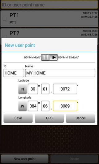
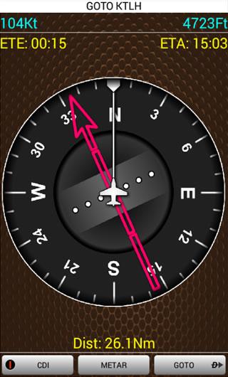
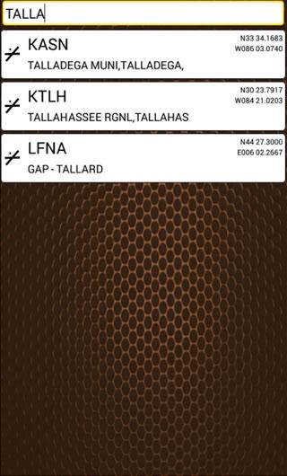
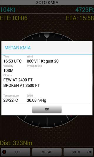
Air Navigator IFR can make a difference inyour cockpit.- This is the GPS APP that can not miss on your smartphoneduring your flight VFR or IFR.- With it, simply choose one of more than 263.000 waypoints (ILSVOR NDB FIXES OR AIRPORTS) in the database or one of theuser-defined and ready. Just follow the HSI and reach thedestination.- All world covered on most complete database in GoogleMarket:- 17.000+ ICAO Airports- 229.000+ Fixes- 6.600+ ILS- 4.500+ VOR- 6.200+ NDB- Another important feature is that any time you can see thedecoded METAR of destination airport with only one touch on thescreen.- Designed to be simple to use, no complicated functions andwithout maps, which, in many cases, hinder and confuse the userwith small screen devices.- To further facilitate the user's life, this APP has beentranslated into three languages (English, Spanish and Portuguese)which are adjusted according to the language of yoursmartphone.Tags: navigation, navigator, aircraft, airplane, plane,aviation, pilot, METAR, GPS, HSI,navegación, navegador, avión, aviación, piloto, navegação, avião,aeronave, aviação, IFR, VFR

Air Navigator Slim 3.57 APK
Air Navigator Slim can make a difference inyour cockpit.- This is the GPS APP that can not miss on your smartphone whenyou go flying.- With it, simply choose one of over 17,000 airports in thedatabase or one of the user-defined and ready. Just follow the HSIand reach the destination.- Another important feature is that any time you can see thedecoded METAR of destination airport with only one touch on thescreen.- Designed to be simple to use, no complicated functions andwithout maps, which, in many cases, hinder and confuse the userwith small screen devices.- To further facilitate the user's life, this APP has beentranslated into three languages (English, Spanish and Portuguese)which are adjusted according to the language of yoursmartphone.Tags: navigation, navigator, aircraft, airplane, plane,aviation, pilot, METAR, GPS, HSI,navegación, navegador, avión, aviación, piloto, navegação, avião,aeronave, aviação

ATC Latin America 1.0 APK
In this air traffic control game, you mustcontrol all aircraft in your airspace and deliver them to the endof the ramp control tower. Each aircraft landed accumulate pointsand each 2000 points next airport will be unlocked.Go ahead, control aircraft throughout Latin America (there are10 countries and 55 airports).Unlock airports.Earn points and not let any accident happen.

Aviation Flight Recorder 1.01 APK
Record, organize and analize your flights withAviation Flight RecorderApplication to general aviation or commercial aviation- Record your flights and get complete information suchas:Time on groundTime on flightAverage speed, anddistance traveled- Know exactly how many hours flown- Review and analize your flights- Export to KML format to see your flight in Google Earththree-dimensional shape- View statistics of your flights in various categories- No matter what type of aircraft you fly (piston aircraft, Jetaircraft or helicopter)- Can be used even when you fly as a passenger- Easy to use platform- Easy setup- APP developed for smartphones and tablets

Heli Navigator BR 3.57 APK
Brazil has the fourth largest fleet ofhelicopters in the world, and to meet the demand of this growingmarket, Aerosoft has created a unique navigator to help pilotsflying in this country.- All airports and helipads in Brazil- With it, simply choose one airport or helipad in the databaseor one of the user-defined and ready. Just follow the HSI and reachthe destination.- Another important feature is that any time you can see thedecoded METAR of destination airport with only one touch on thescreen.- Designed to be simple to use, no complicated functions andwithout maps, which, in many cases, hinder and confuse the userwith small screen devices.- To further facilitate the user's life, this APP has beentranslated into three languages (English, Spanish and Portuguese)which are adjusted according to the language of yoursmartphone.
Similar Apps Show More...

Air Navigator IFR 3.57 APK
Air Navigator IFR can make a difference inyour cockpit.- This is the GPS APP that can not miss on your smartphoneduring your flight VFR or IFR.- With it, simply choose one of more than 263.000 waypoints (ILSVOR NDB FIXES OR AIRPORTS) in the database or one of theuser-defined and ready. Just follow the HSI and reach thedestination.- All world covered on most complete database in GoogleMarket:- 17.000+ ICAO Airports- 229.000+ Fixes- 6.600+ ILS- 4.500+ VOR- 6.200+ NDB- Another important feature is that any time you can see thedecoded METAR of destination airport with only one touch on thescreen.- Designed to be simple to use, no complicated functions andwithout maps, which, in many cases, hinder and confuse the userwith small screen devices.- To further facilitate the user's life, this APP has beentranslated into three languages (English, Spanish and Portuguese)which are adjusted according to the language of yoursmartphone.Tags: navigation, navigator, aircraft, airplane, plane,aviation, pilot, METAR, GPS, HSI,navegación, navegador, avión, aviación, piloto, navegação, avião,aeronave, aviação, IFR, VFR


Navigator PRO 1.9.4 APK
ON SALE FOR A LIMITED TIME!If you are in your country or abroad, online or offline, in yourcar or you travel by foot, Navigator PRO will guide you to arriveto destination as fast as possible. Download this app to get apowerful Android navigation tool and you can be confident thatyou'll arrive where you want no matter what.Navigator PRO is an Android GPS app that lets you find places asfast as possible whether you have an Internet connection or not byusing offline maps, so you avoid phone charges in your country orabroad.The Best Navigation ApplicationNavigator PRO is simply the best choice whether you drive, you walkor you go by bike. Enter your destination by address, name orgeographic coordinates, and Navigator PRO will find the best route.The app uses the GPS locator in your Android device to determineyour position and guides you by voice, so you can keep your eyes onthe road, sidewalk or trail. It can even tell you the names ofstreets, give you guidance to choose the lane and let you know whenyou can expect to reach your destination. Did you make anaccidental wrong turn? No worries. Navigator PRO will find you andupdate the route to get back on track.Easy to Use Online or OfflineWhether you've got an interent connection or not, Navigator PROlets you find yourself on the map or look up a place that you wishto visit. You can save favorite addresses to find again and again.Are you in a new place or do you want to discover some hidden spotsin your hometown? Discover points of interest and you can see thebest way to get to them with just a few taps of the screen.The Best Maps for Pedestrians & CyclistsNavigator PRO will help you discover routes for walking, hiking andbiking. You can discover bus stops, tram stops or train stations tohelp you find the best public transportation. You can even use theapp to find out your current speed and altitude.The following are just some of the features of NavigatorPRO:• Clear HD display of offline maps that will help you avoid roamingcharges• It's suitable for when you drive, you go by bike or by foot• Voice-guided, turn by turn navigation to help you be attentive atthe road• You can add intermediate points on your itinerary• It displays street names and it offers lane guidance so youeasily get sign info at motorway exits• If you deviate from the route then the app automatically findsanother route• You can search addresses or places by categories or geographicalcoordinates• It displays stop signs an you can get warnings when exceeding thespeed limit.• Displays your orientation and position on the map, your speed andeven the altitude• You can add intermediate points on your itinerary• The map will be aligned to your direction of movement• The places are displayed in English or local language• And so much more…How do I use maps on my SD Card?Go to General settings->Data storage folder and choose a folderon extSdCard.Starting Android version 4.4.x Android has changed the rules sothat no application can write to the external SD card anywhereoutside its new standard folder Android/data/[PACKAGE-NAME].So you can only place the data in the standard SD folder:(extSdCard)/Android/data/com.navigatorpro.gpsThis application is based on Osmand project under the GNU GPLv3license and uses high quality data from OSM.

BackCountry Navigator TOPO GPS APK
Download topo maps for an offline outdoornavigator! Use your phone or tablet as an offroad topo mappinghandheld GPS with the bestselling outdoor navigation app forAndroid! Explore beyond cell coverage for hiking and otherrecreation.Download topo maps for the US and many other countries in advance,so you won't need cell coverage for navigation. Use storage memoryfor maps.New: Android Wear support to see navigation at a glance onwristUse GPS waypoints from GPX or KML files, or enter your owncoordinates using longitude/latitude, UTM, MGRS, or grid reference.Using GOTO makes a waypoint a locus for navigation.This uses many publicly available map sources as free downloads.Some additional content available as an in app purchase:-Accuterra Topo Map Source for $19.99/year. This can be purchasedand used with or in instead of the free sources.- Boundary maps for 12 western states from the Bureau of LandManagement(BLM) Overlay for topo maps valued by hunters.-GMU boundaries in some states-Lake Contours in several states.-Content from US TrailMaps including:-ATV, Whitewater, and Equestrian Trail MapsSee the menu under More-> "Purchasing AddOns". They can be shownon top of topo maps.You may try the DEMO version to make sure you like the maps in yourcountry.About topo (topographic) maps: Topo maps show terrain through colorand contours, and are useful for navigation offroad. Topo maps andGPS can be used for hiking, hunting, kayaking, snowshoeing, &backpacker trails.You can create your own maps with Mobile Atlas Creator, or specifya custom tile server. Built in sources include:OpenStreetMaps from MapQuestOpenCycleMaps showing terrain worldwideUS Topo Maps from Caltopo and the USGSUSTopo: Aerial Photography with markup.Canada Topo Maps from ToporamaMarine maps: NOAA RNC Nautical Charts (coastal)USGS Color Aerial photographyTopographic Maps of Spain and ItalyTopo maps of New ZealandJapan GSI maps.Many of the above sources are generally free to use.Use offline topo maps and GPS on hiking trails without cellservice. The GPS in your Android phone can get its position fromGPS satellites, and you don’t have to rely on your data plan to getmaps. Have more fun and safe GPS navigation in thebackcountry.Use as a geocaching navigator by getting a pocket query asGPX.Besides geocaching, use GPS for recording tracks and GPS waypointson your trip, all the while tracking your GPS quest on topographicmaps. It may replace your Garmin handheld GPS.Here are some of the outdoor GPS activities BackCountry Navigatorhas been used for:As a hiking GPS both on hiking trails and off trail.Camping trips to find that perfect camping site or the way back tocamp with GPS.Hunting trips for hunting wild game in rugged areas.Doing recon for a hunt or as your hunting GPSFishing: make it your fishing GPS.Search and Rescue (SAR).Trekking the Pacific Crest trail or other long term hiking.Kayak and canoe treks on inland lakes and streams or marine,coastal waters.Backpacker trips: using topo maps of wilderness areas and nationalforests for navigation on trails with the GPS in your rucksack orbackpack.Find your own ways to have fun in the outdoors. Be a maverick byventuring beyond cell service boundaries with your GPS. Become apro at navigation with GPS for the outdoors.BackCountry Navigator has been on WM devices and preloaded on theTrimble Nomad outdoor rugged device. This Android version is moreflexible, featured, and fun. Create a memory with maps.For a one time fee, this a great addition to the outdoor gear youbought at Cabelas, REI, or another outdoor store. Many have foundthe Android GPS in a phone or tablet to substitute for a Garmin GPSor Magellan GPS, such as the Garmin GPS units Montana, Etrex, orOregon. Android can be your handheld GPS.

SNAV Navigator APK
SNAV Navigator is a shortcut to google maps™ or Waze, you cansimplytype or speak (via voice recognition) an address, and GooglemapsNavigator starts in navigation mode quickly. Navigator isuseful forin-car use. you can program your home address, fivefavorites andit’ll remember your last destinations as well,navigator make itsuper easy to get to where you want to go andallow you to avoidHighways and Tolls easily. Great for drivers whodon’t want to befiddling around with their phones at the wheel,SNAV Navigator willmake the whole process of getting to where youwant to go, andgetting home again, a lot easier as well as lessdistracting forwhen you’re behind the wheel. Snav Navigator doesnot use any"Google API" Google Maps™ & Google voice™ must beinstalled towork. *If in doubt, try the free version first.

NAVIGON Europe APK
Whether on holiday, taking a weekend trip orheading off somewhere as yet unfamiliar – with NAVIGON, you can besure of getting there quickly and safely! Transform your Smartphoneinto a full-performance mobile navigation system that includesonboard maps so that you can always find your way – even when nointernet connection1 is available.Important: Following installation, the app needs further data(maps, etc.) which have to be loaded via WiFi (WLAN).*** Scope of function ***- Support of 18 languages- Onboard map material: only save the road maps on your Smartphonethat you really need. That way, you save on memory space and cannavigate even when no internet connection is available.- Intelligent address entry, including voice entry(1): thanks tothe first-class, simplified address entry, which can be operatedusing the keypad or via voice input, you can find your destinationeven more quickly.- Precise voice commands, including street names: so that you canconcentrate on driving the car.- The latest traffic reports(1, 2): avoid annoying jamsautomatically.- Hazard warnings(1, 2): you can choose to receive alerts of dangerspots such as mobile speed traps.- POI search: find your destination even without entering theaddress directly – locally, Community-based or using AugmentedReality.- Real signage and road sign displays: you always have an overviewthanks to photo-realistic views of junctions and road signs.- Dynamic lane assistant: at junctions where the exit is unclear oron motorway exits, be guided into the right lane every time.- Speed assistant: NAVIGON warns you visually or audibly if you areexceeding the permitted speed limit.- Optimal route: choose the right option for you, from up to threesuggested routes.- Route planning: plan longer trips with several destinations enroute.- Expanded pedestrian navigation: navigate to your destination onfoot too – or use Urban Guidance1,2 if you also want to includepublic transport.- Many other in-app purchases possible: alternative petrolstations, 3D maps showing mountains and valleys, and muchmore.*** Maps ***- Latest Map Guarantee for the latest HERE maps(3) (formerlyNavteq), with the following coverage: AL, AN, AT, BA, BE, BG, BY,CH, CZ, DE, DK, EE, ES, FI, FR, GI, GR, HR, HU, IE, IM, IS, IT, LI,LT, LU, LV, MC, MD, ME, ME, MT, NL, NO, PL, PT, RK, RO, SE, SI, SM,RS, SK, TR, UK, VA- NAVIGON FreshMaps(2): For a one-off payment, you get the latestmap updates from experts up to four times a year, for two years! Itmeans that your app is always up-to-date, containing the latestchanges to the road network and any amount of new points ofinterest.*** Please note the following ***The correct positioning of your Smartphone in the vehicle isimportant for optimum GPS reception. For that reason, we recommendthe Garmin Smartphone Universal Mount with additional USBconnection so that you can also charge your Smartphone during yourtrip. Continuous use of GPS can shorten battery life. Available inspecialist stores or directly from the Garmin Shop atwww.garmin.com.Please also note our FAQ area at www.navigon.com.This version of NAVIGON can require up to 3.4GB of free memory(depending on the number of maps you download). Due to the highdata volume, we recommend using WiFi (WLAN). On first startup ashort data connection (ca. 25kB) is mandatory to register yourproductNAVIGON wishes you a lot of fun from your navigation!(1)To be able to provide you with the latest reports at all times,some functions require an internet connection (e.g. traffic reportsor speed camera alerts). However, the navigation system itself,including address search, speed display, driving lane assistant andmuch more, does not require the internet.(2)Available as an additional in-app purchase.(3)You get the maps most up-to-date at the time you purchase theapp
Transportation Top Show More...


Speed Limiter 2.0 APK
Tired of fines? Speed limiter is there for you!Speed Limiter is an application whose purpose is to warn youin case you drive too fast. It works thanks to the GPS on yourphone.Its simple and clear, you can use it without leaving theroad.The last button indicates the speed at which you drive. Byselecting, you dynamically create a new limitation.

Drive Link 1.1.043 APK
DriveLink is a perfect app for safe, handsfree in-vehicle services that really makes a difference in thedriving.The app can either work as Standalone Mode, which is just launchedin the smartphone, or as Connected Mode,which works by connecting to the car's headunit display viaMirrorLink(TM).For the Connected Mode, the screen of the smartphone is mirroredto the head unit display.The app has been designed to conform to the safety regulation setby Automotive industry standard.The current version has the following features:- Welcome Screen: Context Awareness feature that allows todisplay the current location's weather information,Recently Played Music in the smartphone, Schedule info stored inCalendar app. If the schedule contains an address, the user canclick theaddress to directly navigate to the destination- Music : User can listen to every music file stored in thesmartphone. Also, DriveLink has other music sources such asInternet Radio.Currently, TuneIn and Radioclock App is available.- Phone: User can make a phone call, and send text messages. Theapp retrieves all contact information stored in the smartphone- Shortcut: User can create a shortcut for a specific contact,music, and location.Note:- To use MirrorLink(TM) service in car using USB, the head unitmust support MirrorLink(TM) 1.0.1.- If MirrorLink(TM) service doesn't work in your smartphone, it isnecessary to update a firmware.- Firmware update availability is depending on mobileoperators.

myIowaDOT 1.1.12 APK
The myIowaDOT app has been developed to act as a container forother Iowa Department of Transportation apps. It shows allavailable Iowa Department of Transportation apps, even those appsthat are not currently installed on the device. If an app isselected that is not installed on the device, the user is taken tothat app in Google Play so the app can be installed. Once apps havebeen installed, the myIowaDOT app can be used as a launch pad forthose apps.The list of apps available on the myIowaDOT app is builtdynamically, so new apps will automatically appear in the myIowaDOTapp as they are developed. Users can also create a list of favoriteapps, personalized to meet their needs.Apps that are currently available with myIowaDOT include:Aviation - Contains an Iowa airport directory, aviation weather, anaviation calendar, and NOTAMS (Notice to Airmen)Bike Map - An interactive bike map with bike trail navigation anddriving directionsDL Docs – Helps determine which documents are needed in order toobtain an Iowa Real IDDrive Test – A practice test to help prepare for the Iowa driver'stestERL – The Department’s Electronic Reference Library, which containshighway & bridge construction specifications andstandardsFacebook – The Iowa Department of Transportation’s FacebookpageIowa 511 – Traveler information such as Iowa road conditions,traffic speeds, and traffic camerasLegis – Information about the Iowa Department of Transportation byIowa legislative districtmyMVD – Use this to renew your Iowa driver’s license, change youraddress, or see your driving recordTwitter – The Iowa Department of Transportation’s Twitter feed

Indonesia - iGO NextGen App 9.19.1.540354 APK
Join the millions of users who have alreadychosen iGO navigation all over the world.After downloading the iGO primo application you CAN START TO USE ITIMMEDIATELY. IT WORKS IN OFFLINE MODE, there are NO ROAMING FEES.Your Android phone becomes a FULL VALUE NAVIGATION device, justlike any dedicated satellite navigation device. The maps are partof the application (see details of the coverage below).°°°°°°°°°°°°°°°°°°°°°°°°°HIGHLIGHTS- Fast, short, easy-to-follow, and green routes- Automatic route recalculation- Multipoint-route support- Get social! Share your routes on Facebook!- Navigate to GPS-coordinates, pictures- Local/POI search: find businesses or anything else you needaround your position- Country specific lane guidance & signposts (whereapplicable)- 3D junctions (where applicable)- Smart keyboard&history- Customizable quick menu & vehicle profile- Try out the Customer Support Centre: read tips&tricks, send afeedback.°°°°°°°°°°°°°°°°°°°°°°°°°COUNTRIES COVEREDIndonesia°°°°°°°°°°°°°°°°°°°°°°°°°IMPORTANT TECHNICAL INFORMATIONContinued use of GPS running in the background can dramaticallydecrease battery life. Background navigation has to be turned onwhile using the application;The maps are part of the application, no roaming fees,: no needfor cellular network coverage, no surprises. Map updates aresubject to availability and may come as part of softwareupdates.

TaxiForSure book taxis, cabs 4.3.0 APK
TaxiForSure is a travel experience providerthat helps you book a cab in the simplest way possible. Downloadour free app to get a safe, reliable cab, anywhere, anytime! Be itairport transfer or just an in-city ride, book a cab from yourTaxiForSure app with just a few taps. We make sure a taxi driven bya professional chauffeur arrives at your door on time. No morehaggling with rickshaws, no more waiting for your call to beanswered. Save time and money with our affordable rates and getquick access to thousands of cars driven by our friendly andinformed chauffeurs across India.All taxis can be requested for immediate or future pickups.Simply choose the taxi you like, instantly receive your driverdetails, track the taxi to your address, and pay after completionof the trip. You can view your travel history, modify or canceltrips, save your favorite locations and even go cashless with ourwallet options. Share the tracking link through SMS/ Whatsapp/Email and let your loved ones track you through your journey. Thein-trip SOS alert facility helps you notify emergency contacts andlocal authorities if required.Now the TaxiForSure App also allows you to book an Ola Micro,available at just Rs. 6/km. It also allows you to link and use youOla Money wallet for Micro rides booked on the TaxiForSure app.Advantages of Using the App:• Easy Booking Process• Wide range of car categories• Most affordable rates• Cashless travel with wallet• Airport transfers, City rides.• Save money and time• Trained chauffeursBooking a taxi has never been easier!


Infraction 0.0.1 APK
Ce service est dédié aux propriétaires desvéhicules et aux conducteurs. Il permet la consultation desinfractions enregistrées sur le fichier national des permis deconduire et celui des véhicules. Pour cela l’utilisateur est tenude s’identifier moyennant son numéro de la carte nationaled’identité et le numéro du permis de conduire.This service is dedicatedto vehicle owners and drivers. It allows the consultation ofoffenses recorded on the national register of driving license andthe vehicle. For this the user is required to identify through itsnumber of national ID card and driving license number.