Top 50 Apps Similar to Tropical Hurricane Tracker


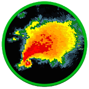
Hurricane Tracker 1.1
After launching on iOS almost 10 years ago, HurricaneTrackerhasfinally made it's way into the Google Play store!Reviewed byCNNas the best Hurricane Tracking app. GOOGLE: "cnn tophurricaneapp"to read the article! Hurricane Tracker is the mostused &mostcomprehensive tracking app available on any platform.WhatmakesHurricane Tracker different from the others in theGooglePlayStore: • Receive push alerts (by region) when a new stormformsorthreatens landfall • 65+ maps/images • In-depthwrittendiscussionsand analysis from our team • Real timeNationalHurricane CenterUpdates (All NHC advisories & maps) •Audiotropical updates •Storm video updates • Custom graphics fromourteam of experts.Exclusive “Alert Level” & “ImpactPotential”maps. Not justbasic NHC info. • Share informationwithfriends/family via email,SMS, Facebook & Twitter •Superdetailed tropical wave/investinformation • Dozens ofsatellites •Much, much more! There is noother Hurricane trackingapp out therethat can match the amount ofinformation you get-weguarantee it.Get the information you needto make informeddecisions. We chargefor our app because it’s notjust an automatedproduct, our team isconstantly creating graphics& writingdetailed discussions tokeep you informed. This isour full time job- keeping you ahead ofthe storms. NOTE*** We donot offer refunds onour app after thestandard Google trialwindow. All sales final.Hurricane Trackercovers The Gulf ofMexico, Caribbean, AtlanticOcean & EasternPacific. Our appalso covers any storms that mayaffect Hawaii. Wedo not coverstorms near Australia and the WesternPacific. CONTACTUS WITH ANYQUESTIONS: Web: www.hurrtracker.comEmail:[email protected]: @hurrtrackerapp (live, realtimeupdates) *HurricaneTracker is an extremely dataintensiveapplication. A WiFi orstrong cellular signal isrecommended for thebest experience.


RadSat HD 1.0.13
RadSat HD is a weather app that allows the integration ofaweatherradar mosaic with GOES-16 satellite imagery,lightning,forecastsmaps and other products. You can view current orfutureweatherradar imagery from the United States, Europe,Australia,Argentina,Brazil and other countries. In addition,satelliteimagery, globallightning (requires subscription) and GFSproductscan be added.With a forecast, we can know the probabilityof rainorthunderstorms for a given day or hour, but with a weatherradarorsatellite, we can know the exact moment that will rain ineachareaand what risks can be expected (heavy lightning,hail,tornadoes,flash flooding). When lightning occurs near yourdevice'slocation,the app will notify you to seek shelter. Formoreinformation or tosuggest improvements, visittheExtendedForecast.net website or ourFacebookpage:/extendedforecast.

Florida Storms 2.0.8
Everything you need, nothing you don't.FloridaStorms is not just another weather app with a radar. It's acleanand fast interactive map that alerts you to every storm,while atthe same time delivers credible real-‐time audio and textalertsfrom the Florida Public Radio Emergency Network. Using acombinationof Baron's exclusive storm track algorithms and theexpertise of ameteorologist, you're certain to receive the mostup-to-dateinformation on any potential weather hazard.View the latest tropical weather updates from the NationalHurricaneCenter, find your nearest evacuation route, check ifyou're in thepath of a dangerous storm surge, or just review achecklist of itemsyour family should have in case of a weatheremergency. Once youhave Florida Storms, you won't need multipleapps to prepare for thenext "big one". Whether it's just a routinepop-up shower thatmight send you indoors or a major hurricanethreatening yourneighborhood, Florida Storms is the simplest andfastest way to stayinformed of mother nature's next move.Features of Florida Storms:• Live radio stream of the nearest Florida Public RadioEmergencyNetwork partner station, with option to choose from 12others inthe state in case of evacuation or traveling• Customizable push notifications from multiple sources,includingthe National Weather Service, the National HurricaneCenter,Baron's exclusive Doppler radar, and local emergencymanagementpersonnel• Able to set location to other cities to track weatherthroughoutthe state and to get warnings for those locations• Watch and warning information from the National WeatherService,with the ability to view the advisory text and radar at thesametime• Fast and clean national radar, with 1-‐hour past loop• Option to load the nearest high-‐resolution Doppler radarinFlorida, also with 1-‐hour loop• Real-‐time lightning data, including positive strikes• National Hurricane Center storm track's and forecasts• Future radar up to 48 hours, with option to pause/play• Current temperatures and wind speeds• Multiple feeds of real-‐time information from varioussources,such as the nearest National Weather Service office, theNationalHurricane Center, Florida Department of Transportation, theFPRENStorm Center and local emergency management offices• Preparedness information for a weather disaster, including whattodo before, during, and after a stormFlorida Storms is completely free and developed by theFloridaPublic Radio Emergency Network, in partnership withMobiquity, Inc.Updates from the FPREN Storm Center are provided bya team of staffmeteorologists at the University of Florida Collegeof Journalismand Communications, and are also available on yourlocal Floridapublic radio station's website or over the air.The Florida Public Radio Emergency Network partners stationsareWUWF (Pensacola), WFSU (Tallahassee), WKGC (Panama City),WUFT(Gainesville), WJCT (Jacksonville), WMFE (Orlando), WMNF andWUSF(Tampa-‐St. Petersburg), WFIT (Melbourne), WQCS (Ft. Pierce),WGCU(Ft. Myers), and WLRN (Miami). Repeater stations includeWJUF(Inverness), WMKO (Marco), WUCF (Orlando), WFSQ (Tallahassee),andWXEL (Miami). More information about the Florida PublicRadioEmergency Network can be found at www.floridastorms.org.


NOAA Weather International
Retrieve real-time 7-day hyperlocalpointweather forecasts and current weather conditions forworldwidelocations from NOAA NWS, Environment Canada & Dark Skybased onyour current location or any location in the world.Not only are NOAA forecasts the most accurate, they provideuniquepoint forecasts for every square mile which take intoconsiderationall the variables affecting the weather at that point,such asaltitude. This is especially useful in locations withhighlydynamic weather patterns and is a great tool forbeingoutdoors.-View forecast & current conditions for yourcurrentlocation.-View forecast & current conditions for any location intheworld by map.-Save favorite locations to quickly retrieve forecastsforthem.-Hourly forecast-Animated radar, cloud cover, precipitation & wind imageryoverGoogle Maps-Map measuring tool to measure distance and elevation-Hazardous weather alerts-Current conditions notification-Home screen widget-Light and Dark Material themes-Optimized for tablets-Android Wear supportIn-app purchase is available to remove ads.Please e-mail me below with any bug reports or featuresrequests.Thanks!


Tide Charts - Free 2.35
Finally a beautiful and simple way to view tides onyourmobiledevice! In addition to worldwide tidal estimates, you canseethelunar data, weather forecast, and current radar makingyournextoutdoor adventure as easy to plan as possible. Bydefault,theapplication will pick the closest station to you, butpickingadifferent station is as easy as viewing a map ofyourcurrentlocation. You can also setup and quickly switch betweenmanystoredfavorite stations if you need to. No internetaccesswhileoutdoors? No problem. This app has been designed to giveyoutidaland lunar predictions without internet access! The firsttimeyoulaunch this application may take up to 3 minutes to startwhileitgenerates textures.


Radar Express - Weather Radar 2.5.11
Radar Express gives you instant access toahigh resolution animated weather radar and all the localweatherinformation you need provided by the NOAA NWS. It's clear,simple,and fast-loading.• Quickly view an HD animated doppler weather radar for anywhereinthe United States.• Check the current temperature and other weather conditions inanyU.S. city.• Read the latest alerts and hazardous weather discussion fromtheNOAA NWS in your area.• Weather radar, alerts, and forecast all come directly fromyourlocal NOAA NWS office.• Forecasts from the NOAA NWS are some of the mostaccurateavailable.Whether you want to know when it will rain, or you need to knowhowstrong the storms are on the horizon and which directionthey'removing, install the Radar Express weather radar app on yourmobilephone or tablet now.Radar Express is neither affiliated with nor endorsed bytheNational Oceanic and Atmospheric Administration or theNationalWeather Service.


Weather for the World
Every day you can quickly and easily find a10day weather forecast for the world supervised 24/24 byMeteoNewsand updated in real time!- Weather forecast for the morning / afternoon / evening- Rainfall radar images- Value of forecast reliability- Probability of sunshine and precipitations- Perceived temperature- Average, mimimum and maximum temparature- Wind force, wind direction, gust force- Limit of snowfall- Limit zero degrees- Fog- Humidity and pressureFind your favorite ski resorts and snow conditions for FranceandSwitzerland- All resorts and snow reports; Skiing - cross-country skiing-sledding- Check the snow conditions through live webcams- See the last snowfall in a snap- Flash TV of the weekend weather, road weather and currents- Alpine webcamExposure for 10 days in landscape mode.- Choose your town or any other city: Bruxelles, Antwerp,Paris,London, New York, Los Angeles, Barcelone, Rio de Janeiro,Zermatt,Milan, Vienna, Berlin, Amsterdam ... and even smallvillages aroundthe WorldContent delivered by MeteoNews


Weather Radar Pro - Get the forecast right 1.0
Weather forecast is one of the best weather apps providingyouhourlyweather forecasts and monthly weather forecasts.WeatherRadar givesyou accurate info on hourly weather forecast anddailyweatherforecast(weather today, weather tomorrow...) proWeatherapp detectsyour current location automatically. There aremanyinformation inweather forecasts in addition to ten daysfutureforecast. Accurateweather forecasts, real-time weatherradaralerts and severe weatherwarnings, with this weather app youwillbe up to date at all times !Weadar will help you getwarnings,storm, rain, hurricane at yourlocation with the stormtracker& hurricane tracker feature. Getthe latest specificsontemperature, rain, probability ofprecipitation, snow,wind,sunshine hours, sunrise and sunset times.Detailed displays ofairpressure, humidity levels and UV-Index.features: •Real-timeweather data and radar animations with blizzard&hurricanetracker: rain, snow, clouds, wind, currenttemperature,humidity,wave, pressure, current • Full report ofdetailed WeatherForecast:location time, temperature, atmosphericpressure, hourlyweathercondition, visibility distance, relativehumidity,precipitation indifferent units, dew point, wind speed,anddirection • Detectlocation by GPS & network to giveyouaccurate and reliableweather forecast. • Search &managemultiple locations manuallyto get your local forecasts andtrackweather conditions in yourcity. • Accurate & reliableforecastapp supportingnotifications • Real-time update widget •Chartgraphs of hourlyweather forecast and daily too, including aproweather radar •Today, tomorrow’s weather, 10 days futureforecast.• Weather appdescription: sunrise & sunset time,humidity,precipitationprobability, visibility, weather conditionsetc. •Change unitsetting of your live weather app: temperature(C/F),time format(12h/24h), precipitation (mm, inch), wind speed(km/h,mi/h, m/s),pressure (mmHg, hPa, mbar) • Weather forecast forallcountries& cities: Australia, Canada Weather, NewZealand,UnitedKingdom (UK), United States, USA Weather forecast(US),Auckland,London, New York, Sydney, Toronto, etc. ϟ LocalRadar,lightning: -Real-time Lightning Strikes as they occurredinselected time range- You can display it as an animation to onehourback in the past.彡 Wind: - Average wind speed 10 meters abovethesurface over thenext 10 days - Especially helpful fortrackinghurricanes and otherstrong wind events. ☂ Rain, thunder:-Rain/snow accumulation inthe last 3 hours, combined withlightningdensity forecast. - Nostorm will hit you unprepared!C°Temperature: - provides thecurrent temperature in CelsiusandFahrenheit, ☁ Clouds: - Theamount of cloud cover forecast inthelast 3 hours ☠ COconcentration: - Carbon monoxide is a toxicgasfor humans andother oxygen-breathing organisms - The level ofCOconcentration inthe troposphere is measured by a systemcalledParts Per Billion byVolume (PPBV). ⚠ Weather warnings: - TheCommonAlerting Protocol(CAP) shows you public warnings andemergencies,it generateswarnings on all possible dangers: Hightemperatures /Lowtemperatures, fires, Air quality,earthquakes,volcanoes,landslides, Flood, Avalanches, Waves &sea, etc - Youcan seewarnings using two filters: colorize byintensity and typeof thewarning We are trying our best to make ourweather forecastappbetter and better. Enjoy your life with ourweatherchannels.Download this pro weather app and share with yourfriends.