


Description
App Information Yacht Navigator |Kartenplotter
- App NameYacht Navigator |Kartenplotter
- Package Namede.deliusklasing.yachtnavigator
- UpdatedMay 21, 2016
- File SizeUndefined
- Requires AndroidAndroid 4.0 and up
- Version1.8.0
- DeveloperDelius Klasing Verlag
- Installs10,000 - 50,000
- PriceFree
- CategoryTravel & Local
- Developer
- Google Play Link
Delius Klasing Verlag Show More...

Yacht Navigator |Kartenplotter 1.8.0 APK
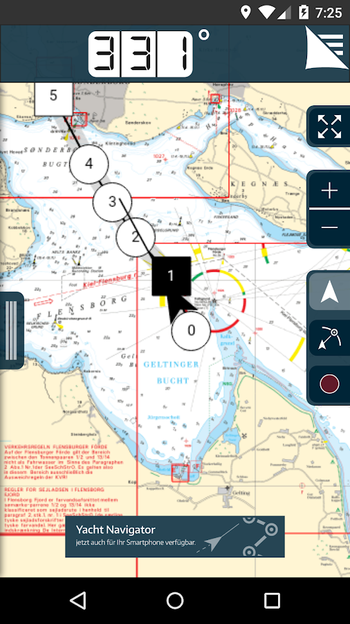
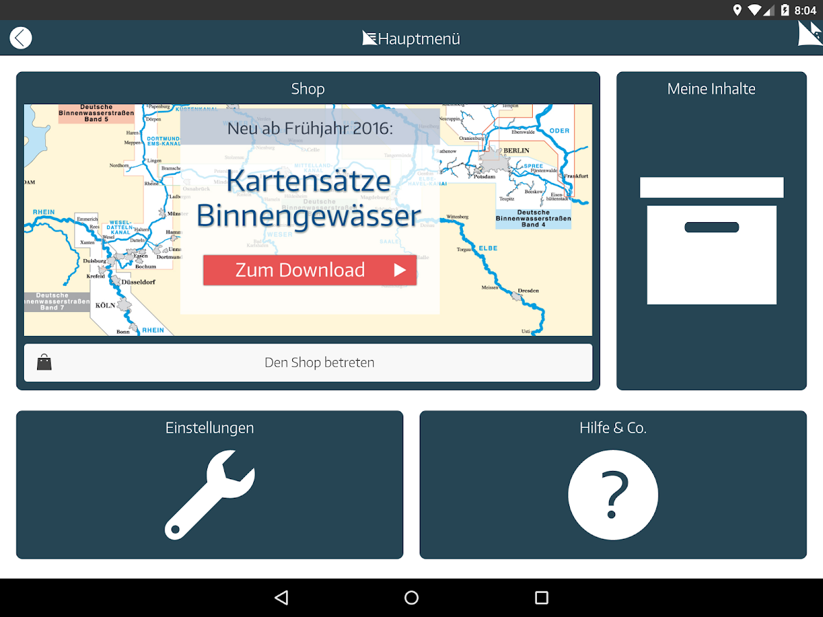
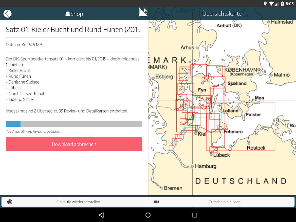
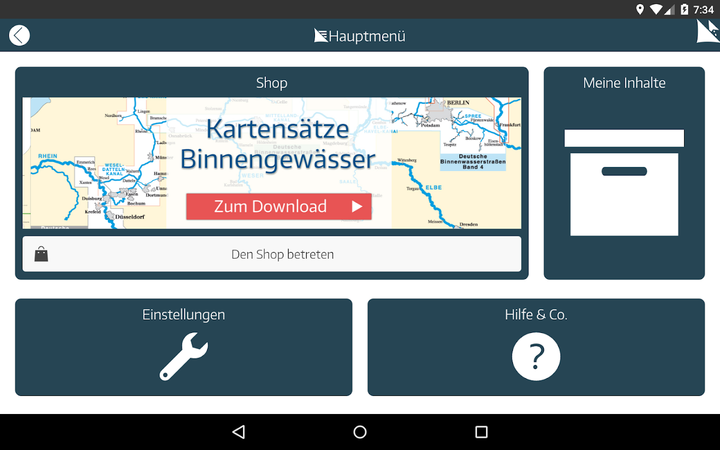
Mit dem Yacht Navigator können Sie auf ihremTablet einfach und intuitiv in Echtzeit navigieren. Die YachtNavigator App basiert auf dem Kartenmaterial der gedrucktenSportbootkarten von Delius Klasing.App inklusive kostenlosem Probekartensatz. Weitere Kartensätze sindüber In-App-Kauf erhältlich.### AKTUELLES – RABATT-AKTION+ Delius Klasing Sportbootkartensätze 2015 können zu einem Preisvon 19,99€ aus der App heraus bezogen werden. Zur Einführung derApp ist folgende Funktion in der App stark rabattiert:+ Pro-Version/Keine Werbung (0,99€ statt 3,99€)### DIE WICHTIGSTEN FUNKTIONEN+ blattschnittfreie, gleitende Kartendarstellung+ Offline-Navigation (nur zum Download der Karten wird eineInternetverbindung benötigt)+ Kompass (COG) als Digital- und Analoganzeige+ Intelligentes Peilwerkzeug (Ein-Finger-Bedienung möglich)### TRACKING-FUNKTION+ Aufzeichnen und Anzeigen der gefahrenen Strecke+ Auswahl verschiedener Farben zur deutlichen Unterscheidung derTracks+ Immer erreichbarer Button zum schnellen Starten und Stoppen derAufzeichnung+ Anzeige von Detailinformationen (wie z. B. gefahrene Strecke oderHöchstgeschwindigkeit) zum Track### ROUTEN-FUNKTION+ Einfache und komfortable Planung von Routen+ Visuelle Unterstützung beim Abfahren von Routen+ Anzeige der Peilung zum nächsten Wegepunkt im Kompass+ Automatischer Wechsel zum nächsten Wegepunkt beim Abfahren einerRoute+ Dynamische Anzeige von verbleibender Fahrtzeit undAnkunftszeit### WEITERE FUNKTIONEN+ Positionierung in der Karte: Intern (GPS, Mobilfunknetz)+ Einfaches stufenloses Zoomen der Karte (Ein-Finger-Bedienungmöglich)+ Personalisierung der gewünschten Anzeigewerte (SOG, POS,etc.)+ Rechts-/Linkshänder-Modus für die optimierte, personalisierteBedienung+ Darstellung des gefahrenen Kurses sowie eines Vorausvektors inder Karte+ Hochrechnung des Kraftstoffverbrauchs beim Abfahren einerRoute### KARTENMATERIALDie digitalen Delius Klasing-Sportbootkarten sind auf diebesonderen Bedürfnisse der Sportschifffahrt zugeschnitten. GünstigeMaßstäbe, eine klare farbige Kennung und eine übersichtlicheDarstellung sind die wesentlichen Vorzüge der nautischen Karten fürdiese Reviere. Insbesondere bei diesen digitalen Karten spielt dieexakte Positionsgenauigkeit eine wichtige Rolle.Die gesamte Küstenlinie des jeweiligen Reviers ist imgrößtmöglichen Maßstab, mindestens 1:50 000, erfasst. Für Fahrtenim offenen Seegebiet gibt es in jedem Kartensatz mindestens einepraktische Übersegler-Karte, für nautisch anspruchsvolle ReviereDetailkarten in verschiedenen hochauflösenden Maßstäben. Diese hoheMaßstabsvielfalt ermöglicht es dem Skipper immer den richtigenBildbereich der Karten auf dem Bildschirm darstellen zulassen.Die verschiedenen Tiefenbereiche sind in den Karten farblich in 2-und 4- bzw. 5-m-Bereiche abgestuft, sodass einerseits Untiefen undandererseits die ungefährdet schiffbaren Tiefenbereiche auf denersten Blick erfasst werden können. Zudem ist die besonderswichtige 2-m- bzw. 3-m-Tiefenlinie rot hervorgehoben. SchwimmendeSeezeichen sind farbig dargestellt und somit leicht zuidentifizieren. Wie weltweit bei allen Seekarten üblich, sind inden Delius Klasing-Kartensätzen die internationalen Bezeichnungender Kennungen und Leuchtfeuer verwendet.Die Delius Klasing-Sportbootkarten werden – soweit möglich – aufGrundlage der amtlichen Kartendaten der nationalen hydrografischenInstitute erstellt.### SYSTEMVORAUSSETZUNGENAndroid-Tablets mit einer Bildschirmgröße ab 7 Zoll und mindestenseiner Android-OS Version ab 4.1 oder höher.With the Yacht Navigatoryou can navigate in real time easily and intuitively on yourtablet. The Yacht Navigator app is based on the maps of the printedleisure charts by Delius Klasing.App including free sample card pack. Other card sets are availablethrough in-app purchase.### NEWS - Discount offer+ Delius Klasing leisure charts sets 2015 can be purchased at aprice of 19.99 € from within the app. To introduce the followingfunction in the App App is heavily discounted:+ Pro version / No Advertising (0.99 € instead 3,99 €)### KEY FEATURES+ Free of sheet lines, moving map display+ Offline Navigation (only for downloading the maps is an internetconnection required)+ Compass (COG) as a digital and analogue display+ Intelligent Peilwerkzeug (one-finger operation possible)### Tracking feature+ Recording and displaying the distance traveled+ Choice of different colors to clearly distinguish thetracks+ Always reachable quick launch button for and stop recording+ Display detailed information (such. As distance traveled orspeed) to track### ROUTES FEATURE+ Simple and convenient planning of routes+ Visual support when exiting routes+ Display of the bearing to the next waypoint in compass+ Automatic change to the next waypoint when traveling along aroute+ Dynamic display of remaining journey time and arrival time### MORE FUNCTIONS+ Positioning on the map: Intern (GPS, cellular network)+ Simple continuous zoom the map (one-finger operationpossible)+ Personalizing the desired display values (SOG, POS, etc.)+ Right / left-handed mode for optimized, personalizedoperation+ Presentation of the course as well as a driven advance vector inthe map+ Extrapolation of fuel consumption when traveling along aroute### MAPSThe digital Delius Klasing-leisure charts are tailored to thespecific needs of recreational boating. Cheap standards, a clearcolor code and a clear display are the main advantages of thenautical maps for these areas. Especially with these digital mapsthe precise location accuracy plays an important role.The whole coastline of each mining area is to the maximum scale atleast 1:50 000 detected. For drives in open sea area there is ineach set of maps at least one skill over sailors card for demandingnautical areas detailed maps in different high resolutionstandards. This high scale diversity allows the skipper always berepresented the right screen area of the map on the screen.The different depth ranges are color graded in the cards in the 2-and 4- or 5-m-ranges, so that on the one hand and the other handthe shallows safely navigable depth ranges can be detected at firstglance. In addition, the particularly important 2-m and 3-m-deepline is highlighted in red. Floating navigation marks are displayedin color, and thus easy to identify. As worldwide common to allcharts, the international names of identifiers and beacons are usedin the Delius Klasing-card sets.The Delius Klasing-leisure charts are - as far as possible -created based on the official map data of national hydrographicinstitutions.### SYSTEMAndroid tablets with a screen size from 7 inches and at least oneAndroid OS version from 4.1 or later.

TOUR international 2.0.7 APK
Try out the new TOUR international App withthe latest in road bike tests, reviews and articles. TOURinternational is from TOUR, Europe’s No. 1 road bike magazine,published in Germany. Our large staff of editors is well known inthe industry for being meticulous and exact, independent and fair.But until now, you could only get TOUR in German. Not any more!Published online in English four times a year, TOUR internationalis aimed at an international audience. We offer in-depth road biketesting and reviews that you can’t get anyplace else. We do labtests, riding comparisons and extensive wind tunnel tests. Ourreviews are accurate, detailed and we don’t pull any punches; ifthere’s a problem with a bike or a component, we’ll let you know.You can now receive the essence of TOUR, including all our majortests, on your iPad. The App itself is free, you simply pay foreach issue of TOUR international that you choose to download.There’s no subscription or hidden obligation, so give it a trytoday

shapeSECRETS 1.0.0 APK
I will be fit!Fit and slim, permantely – all this with a short fitnessscheme,only a few minutes per day. Nina Winkler, one of Germanysbestknown fitness experts has developed an app for people withlittletime to achieve the best possible work out.The app contains descriptive composed video workouts forthefollowing fitness areas:- Body Forming (Level 1–3),- Yoga (Level 1–3)- Fatburning (Level 1–2).Each level is divided into two to three levels(difficultylevels) and each level incorporates different exercises.Inaddition, there is an arrangement of all available levelsforlonger work outs attached to each level.On this free trial app one exercise can be downloaded free ofchargeas a test. In addition further exercises can bepurchased.As well, a series with the same title is on offer, containingofminis and videos.Nina Winkler presents a unique exercise regime:The „10 x 2 Minute-Formula”: per exercise only two minutes ofyourtime – 20 minutes per day are enough- Effektiv body toning, muscle build up, increase of fitnessandwell beingAn overview of all in-apps and prices can be found at the end ofthetext.You would like to shape your body with the leastnecessarytime?No problem, with this app you will succeed.This app offers non bindingly and free of charge a video of level1of the body forming exerciseAll in all the app contains of 12 extensive and descriptivevideowork outs, the whole running time of more than fivehours.The single exercise levels can be purchased as a bundleaswell.The app offers the following three video bundle packages betwenn€7,99 and € 9,99:(The videos can be purchased individually at a price of €0,89each.)1. shapeSECRETS – Body forming (Trouble Zones)(7,99 €):• Level 1 (free of charge)• Level 2 (3,59 €)• Level 3 (3,59 €)• Level 1-3 (5,49 €)2. shapeSECRETS – Yoga (9,99 €):• Level 1 (3,59 €)• Level 2 (3,59 €)• Level 3 (3,59 €)• Level 1-3 (6,99 €)3. shapeSECRETS – Fatburning (7,99):• Level 1 (3,59 €)• Level 2 (3,59 €)• Level 1-2 (5,49 €)


Similar Apps Show More...

Maps & GPS Navigation OsmAnd+ APK
OsmAnd+ (OSM Automated Navigation Directions)is a map and navigation application with access to the free,worldwide, and high-quality OpenStreetMap (OSM) data.Enjoy voice and optical navigation, viewing POIs (points ofinterest), creating and managing GPX tracks, using contour linesvisualization and altitude info, a choice between driving, cycling,pedestrian modes, OSM editing and much more.OsmAnd+ is the paid application version. By buying it, you supportthe project, fund the development of new features, and receive thelatest updates.Some of the main features:Navigation• Works online (fast) or offline (no roaming charges when you areabroad)• Turn-by-turn voice guidance (recorded and synthesizedvoices)• Optional lane guidance, street name display, and estimated timeof arrival• Supports intermediate points on your itinerary• Automatic re-routing whenever you deviate from the route• Search for places by address, by type (e.g.: restaurant, hotel,gas station, museum), or by geographical coordinatesMap Viewing• Display your position and orientation• Optionally align the picture according to compass or yourdirection of motion• Save your most important places as Favorites• Display POIs (point of interests) around you• Display specialized online tiles, satellite view (from Bing),different overlays like touring/navigation GPX tracks andadditional layers with customizable transparency• Optionally display place names in English, local, or phoneticspellingOnly this week 50% OFFUse OSM and Wikipedia Data• High-quality information from the best collaborative projects ofthe world• OSM data available per country or region• Wikipedia POIs, great for sightseeing• Unlimited free downloads, directly from the app• Compact offline vector maps updated at least once a month• Selection between complete region data and just road network(Example: All of Japan is 700 MB or 200 MB for the road networkonly)Safety Features• Optional automated day/night view switching• Optional speed limit display, with reminder if you exceedit• Optional speed-dependent zooming• Share your location so that your friends can find youBicycle and Pedestrian Features• Viewing foot, hiking, and bike paths, great for outdooractivities• Special routing and display modes for bike and pedestrian• Optional public transport stops (bus, tram, train) including linenames• Optional trip recording to local GPX file or online service• Optional speed and altitude display• Display of contour lines and hill-shading (via additionalplugin)Directly Contribute to OSM• Report data bugs• Upload GPX tracks to OSM directly from the app• Add POIs and directly upload them to OSM (or later ifoffline)• Optional trip recording also in background mode (while device isin sleep mode)OsmAnd is open-source and actively being developed. Everyone cancontribute to the application by reporting bugs, improvingtranslations or coding new features. The project is in a livelystate of continuous improvement by all these forms of developer anduser interaction. The project progress also relies on financialcontributions to fund coding and testing of newfunctionalities.Approximate map coverage and quality:• Western Europe: ****• Eastern Europe: ***• Russia: ***• North America: ***• South America: **• Asia: **• Japan & Korea: ***• Middle East: **• Africa: **• Antarctica: *Most countries around the globe available as downloads!From Afghanistan to Zimbabwe, from Australia to the USA. Argentina,Brazil, Canada, France, Germany, Mexico, UK, Spain, ...

Boating HD 8.0.1 APK
The world's most popular marine &lakesapp! A favorite among cruisers, sailors, fishermen and divers.Findthe same detailed charts as on the best GPS plotters. Downloadtheapp, then go to Menu>Charts and select your region to get a14day free trial to the overwhelming value of Navionics+.NAVIONICS+ includes:√ Download of the following chart layers that will reside onyourdevice even after expiration:- NAUTICAL CHART for all essential cartographic referencedetail.The most accurate and thorough set of information basedonHydrographic Office data, Notices to Mariners, newpublications,our own surveys, and reports from users. It providesport plans,safety depth contours, marine services info, tides ¤ts,navigation aids and more.- SONARCHART™: the award-winning 1 ft/ 0,5 m HD bathymetry mapthatreflects ever-changing conditions. Be part of the communityandcontribute by uploading your sonar logs to enhance it.- COMMUNITY EDITS made by users (rocks, wrecks, etc.) and sharedforall to benefit.√ CHART UPDATES: we deliver more than 2,000 updates every day!Takeadvantage of our updates as frequently as you like.√ ADVANCED MAP OPTIONS to highlight Shallow Areas, and filterDepthContours. Includes a Fishing Mode that enables Fishing Rangefortargeting key fishing areas.√ NAVIGATION MODULE for advanced route planning with ETA,distanceto arrival, heading to WP, fuel consumption and more!√ DOCK-TO-DOCK AUTOROUTING quickly creates detailed routeseventhrough narrow waterways and channels, based on chart dataandnavigation aids. POIs are automatically shown nearbyyourdestination.√ WEATHER & TIDES provides real-time weather data andforecasts.Access daily and hourly forecasts for your favoritelocations andget wind, weather buoys, Tides & Currentsoverlaid on yourmap.Buoy data is retrieved from NOAA and can include wind speed,gustand direction as well as air pressure, water temperature,waveheight and other relevant marine data.Note: Download detailed maps by zooming in orfromMenu>Download Map. Check navionics.com for coverage.Navionics+ is a one year subscription. At expiration you canrenewwith a discount of up to 50%. If you don’t renew, you canstill usethe charts you previously downloaded, along with severalfreefeatures:TRACK your journey, view speed, distance, time and COG. Savetoarchive, see stats and playbackROUTES: create and edit, based on speed and fuel consumptionMeasure DISTANCE, add MARKERS, get WIND FORECASTS andsun/mooncyclesMAP OPTIONS: Satellite/Terrain, adjust shorelines to selectedWaterLevel, choose Depth Shading and Easy View to beginSYNC Tracks, Routes & Markers among your mobile devicesMAGAZINES & GUIDES for location-based articles fromleadingindustry publishersSONARCHART ™ LIVE - allows you to create new personal 1ft/0.5 mHDbathymetry maps that display in real time while navigating.Uploadyour sonar logs to build even better local charts for yourareaconnecting wirelessly to a compatible sounder/plotter.PLOTTER SYNC - NEW! Plotter Sync may also provide accesstoDock-to-dock Autorouting, SonarChart Live and Advanced MapOptionsfor your GPS plotter. Learn moreatwww.navionics.com/en/plotter-syncNavionics has certified several Android models where the appisdesigned to load and operate correctly with an OS of 4.0 orhigher.Please refer to our Compatibility Guide, which iscontinuouslyupdated athttp://www.navionics.com/en/compatibility/mobile. Wecannotguarantee flawless operation or provide support fornon-certifieddevices. ALL SALES ARE FINAL on Google Play.

Boating 8.1 APK
The world's most popular marine & lakesapp! A favorite among cruisers, sailors, fishermen and divers. Findthe same detailed charts as on the best GPS plotters. Download theapp, then go to Menu>Shop and select your region to get a 14-dayfree trial to the overwhelming value of Navionics+.If you have a tablet, please search our HD app.NAVIONICS+ includes:√ Download of the following chart layers that will reside onyour device even after expiration:- NAUTICAL CHART for all essential cartographic reference detail.The most accurate and thorough set of information based onHydrographic Office data, Notices to Mariners, new publications,our own surveys, and reports from users. It provides port plans,safety depth contours, marine services info, tides & currents,navigation aids and more.- SONARCHART™: the award-winning 1 ft/ 0,5 m HD bathymetry map thatreflects ever-changing conditions. Be part of the community andcontribute by uploading your sonar logs to enhance it.- COMMUNITY EDITS made by users (rocks, wrecks, etc.) and sharedfor all to benefit.√ CHART UPDATES: we deliver more than 2,000 updates every day!Take advantage of our updates as frequently as you like.√ ADVANCED MAP OPTIONS to highlight Shallow Areas, and filterDepth Contours. Includes a Fishing Mode that enables Fishing Rangefor targeting key fishing areas.√ NAVIGATION MODULE for advanced route planning with ETA,distance to arrival, heading to WP, fuel consumption and more!√ DOCK-TO-DOCK AUTOROUTING quickly creates detailed routes eventhrough narrow waterways and channels, based on chart data andnavigation aids. POIs are automatically shown nearby yourdestination.√ WEATHER & TIDES provides real-time weather data andforecasts. Access daily and hourly forecasts for your favoritelocations and get wind, weather buoys, Tides & Currentsoverlaid on your map. Buoy data is retrieved from NOAA and caninclude wind speed, gust and direction as well as air pressure,water temperature, wave height and other relevant marine data.Note: Download detailed maps by zooming in or fromMenu>Download Map. Check navionics.com for coverage.Navionics+ is a one year subscription. At expiration you can renewwith a discount of up to 50%. If you don’t renew, you can still usethe charts you previously downloaded, along with several freefeatures:- TRACK your journey, view speed, distance, time and COG. Save toarchive, see stats and playback.- ROUTES: create and edit, based on speed and fuelconsumption.- Measure DISTANCE, add MARKERS, get WIND FORECASTS and sun/mooncycles.- MAP OPTIONS: Satellite/Terrain, adjust shorelines to selectedWater Level, choose Depth Shading and Easy View to begin.- SYNC Tracks, Routes & Markers among your mobiledevices.- MAGAZINES & GUIDES for location-based articles from leadingindustry publishers.- SONARCHART ™ LIVE - allows you to create new personal 1ft/0.5 mHD bathymetry maps that display in real time while navigating.Upload your sonar logs to build even better local charts for yourarea connecting wirelessly to a compatible sounder/plotter.- PLOTTER SYNC - Compatible Wi-Fi enabled plotter owners cantransfer routes and markers, activate and update their eligibleplotter card and upload sonar logs for improved SonarChart™! Learnmore at www.navionics.com/en/plotter-syncNavionics has certified several Android models where the app isdesigned to load and operate correctly with an OS of 4.0 or higher.Please refer to our Compatibility Guide, which is continuouslyupdated at http://www.navionics.com/en/compatibility/mobile. Wecannot guarantee flawless operation or provide support fornon-certified devices.ALL SALES ARE FINAL on Google Play.

Boating Europe 8.2.1 APK
The world's most popular marine & lakesapp! A favorite among cruisers, sailors, fishermen and divers. Findthe same detailed charts as on the best GPS plotters. This appincludes the overwhelming value of Navionics+. Alternatively, youmay have found a free version on the store offering basic features,where Navionics+ can be purchased In-App. If you have a tablet,please search our HD app.NAVIONICS+ includes:√ Download of the following chart layers that will reside on yourdevice even after expiration:-NAUTICAL CHART for all essential cartographic reference detail.The most accurate and thorough set of information based onHydrographic Office data, Notices to Mariners, new publications,our own surveys, and reports from users. It provides port plans,safety depth contours, marine services info, tides & currents,navigation aids and more.-SONARCHART™: the award-winning 1 ft/0.5m HD bathymetry map thatreflects ever-changing conditions. Be part of the community andcontribute by uploading your sonar logs to enhance it.-COMMUNITY EDITS made by users (rocks, wrecks, etc.) and shared forall to benefit.√ CHART UPDATES: we deliver more than 2,000 updates every day! Takeadvantage of our updates as frequently as you like.√ DOCK-TO-DOCK AUTOROUTING quickly creates detailed routes eventhrough narrow waterways and channels, based on chart data andnavigation aids. POIs are automatically shown nearby yourdestination.√ NAVIGATION MODULE for advanced route planning with ETA, distanceto arrival, heading to WP, fuel consumption and more!√ ADVANCED MAP OPTIONS: overlay Satellite/Terrain, highlightShallow Areas, filter Depth Contours and enable a Fishing Range totarget key fishing areas.√ PLOTTER SYNC - Compatible Wi-Fi enabled plotter owners cantransfer routes and markers, activate and update their eligibleplotter card and upload sonar logs for improved SonarChart™! Learnmore at www.navionics.com/en/plotter-sync√ WEATHER & TIDES provides real-time weather data andforecasts. Access daily and hourly forecasts for your favoritelocations and get wind, weather buoys, Tides & Currentsoverlaid on your map. Buoy data from NOAA can include wind speed,gust and direction as well as air pressure, water temperature, waveheight and other relevant marine data.Note: Download detailed maps by zooming in or from Menu>DownloadMap. Check navionics.com for coverage.Navionics+ is a one year subscription. At expiration, you can renewwith a discount of up to 50%. If you don’t renew, you can still usethe charts you previously downloaded, along with several freefeatures:TRACK your journey, view speed, distance, time and COG.ROUTES: create and edit, based on speed and fuel consumptionMeasure DISTANCE, add MARKERS, get WIND FORECASTS and sun/mooncyclesMAP OPTIONS: adjust shorelines to selected Water Level, chooseDepth Shading and Easy View (not on Govt. Charts)SYNC Tracks, Routes & Markers among your mobile devicesMAGAZINES & GUIDES for location-based articles.GOVT. CHART in USSONARCHART™ LIVE - allows you to create new personal 1ft/0.5 m HDbathymetry maps that display in real time while navigating. Uploadyour sonar logs to build even better local charts for your areaconnecting wirelessly to a compatible sounder/plotter.Navionics has certified several Android models where the app isdesigned to load and operate correctly with an OS of 4.0 or higher.Please refer to our Compatibility Guide, which is continuouslyupdated at http://www.navionics.com/en/compatibility/mobile. Wecannot guarantee flawless operation or provide support fornon-certified devices. ALL SALES ARE FINAL on Google Play.

Metro ★ Navigator 3.2.3 APK
Awesome navigator for metro of differentcities around the world. All maps are interactive, relevant andattractive.★ Highlights ★✔ Fully interactive maps✔ Route planning, timetables, powerful search✔ Can operate offline✔ Dark and Light themes✔ Additional services for most touristic cities (next train,stations schemes, lines statuses, closed stations, faults anddelays on map, tickets reading via NFC)Available metro schemes:★ USA ★1. New York2. Washington3. Los Angeles County★ United Kingdom ★1. London tube2. London tube + National Rail in Z1-6★ Russia ★1. Moscow2. Saint Petersburg3. Ekaterinburg4. Kazan5. Nijniy Novgorod6. Novosibirsk7. Samara★ Spain ★1. Madrid2. Barcelona3. Valencia4. Seville★ Canada ★1. Toronto★ France ★1. Paris★ Republic of Singapore ★1. Singapore★ Ukraine ★1. Kiev2. Kharkiv3. Dnepropetrovsk★ Belarus ★1. Minsk★ Germany ★1. Berlin2. Munich3. Nuremberg★ Mexico ★1. Mexico★ Brazil ★1. São Paulo★ Czech Republic ★1. Prague★ Japan ★1. Tokyo2. Osaka★ Greece ★1. Athens★ South Korea ★1. Seoul★ China ★1. Hong Kong2. Beijing3. Shanghai4. Guangzhou★ Italy ★1. Rome2. Milan★ Sweden ★1. Stockholm★ India ★1. Delhi★ Malaysia ★1. Kuala Lumpur★ United Arab Emirates ★1. Dubai★ Austria ★1. ViennaREQUIRED PERMISSIONS:* CHANGE YOUR AUDIO SETTINGSIt is necessary to mute the player in headphones, when the programannounces current station's name by the voice* COARSE (NETWORK-BASED) LOCATIONTo determine current location by GSM transmitters of mobileoperators* FINE (GPS) LOCATIONTo find the nearest station in the city* FULL INTERNET ACCESSDownload train timetables, info about metro service status,information about time of the next train* READ PHONE STATE AND IDENTITYFor information on the current GSM or Wi-Fi cell. Binding licenseto Market* MODIFY/DELETE USB STORAGE CONTENTS MODIFY/DELETE SD CARDCONTENTSSaving navigation data on SD-card. Saving current route as pictureon SD-card to send to a friend.* PREVENT DEVICE FROM SLEEPINGPrevent phone from sleep when uses navigation* CHANGE WI-FI STATETo find Wi-Fi spots on subway stations and determine current userlocation in the underground (activated only if you allow to useWi-Fi in phone settings)

Fisherman Navigator APK
Convenient saving and searching for your geopoints,recordingtracks, offline maps (fishing, historical, topographic,your own)it's not a full list of the main functionality of the app.Theapplication has been created for the most convenient andeasiestnavigation in the fishing conditions. Later, thisapplication wasalso liked by treasure hunters, mushroom pickers,tourists,hunters, etc. The creator of the application is afishermanhimself, and initially, the application has been createdforpersonal usage, because of lack of usability in previouslytestedapps. We decided to share our app with the improved userexperienceand hope you will like it. Features: - Any kinds ofOffline Mapsfor every taste: fishing (with depths), historical(Schubert,Mende, Red Army), topographic (General Staff, Open StreetMaps) andothers - Use your maps offline ( ozf, ozf2, mbtilesformats) -Convenient work with layers (you can place several layersabove themap and set them different transparency) - Show thecoordinates,and their accuracy - Save geopoints when shaking thephone. Setgeopoints different colors, shapes and sizes. - Records asoundcomment to the geopoint after saving, which you can listen inthedescription of the geopoint. - Take a photo to the geopointthatwill be shown in the description of the geopoint. - Sendgeopointsvia SMS, mail or any other way - Geopoint search mode byvoiceprompts. - Records a movement track - Shows a map and yourlocationon it - Shows saved geopoints and tracks on the map - Showstheaccuracy of the geopoints, in the circle in which it is located-Allows you to name and give detailed descriptions of geopointsandtracks - Convenient geopoints search by clicking on it - Abilitytoexport and import geopoints and tracks in gpx format - Syncpointswith the cloud, backup Now added support for Wear OS smartwatches.You can save point and control track recording byinteractions withyour watches! In the future upgrades we areplaning additionalfeatures: - easy and convenient navigation to thegeopoint -offline maps - ability to view track on the map Our website withFAQ and other useful information-https://sites.google.com/view/susaninnavigator/faq Subscribe toourInstagram to stay in touch and get the latest updates, you canalsotalk to us in Englishhere:https://www.instagram.com/fishermannavigator We are alwaysopen toyour ideas and suggestions! What other tutorials are needed?whatfeatures would you like to receive in the next versions oftheapplication? what comments you have to existing functions - donothesitate, write in reviews or by mail. Enjoy and don't hesitatetoask us anything. Good luck!


Navitel Navigator GPS & Maps v11.11.917 APK
Navitel Navigator is a precise offline GPSnavigation with free geosocial services and detailed maps of 64countries. Try popular navigation for 7 day free!______________________________* 20M DOWNLOADS WORLDWIDE ** TOP 5 NAVIGATION IN 12 COUNTRIES!*ADVANTAGES• Offline navigation. No Internet connection required for the useof the program and maps: No additional expenses on roaming ordependency on mobile connection.• Access to maps at any time: Maps are downloaded to the internalmemory of a device or an SD-card.• Map subscription: Map purchase for a limited period (1 year) withprices starting at 10.99$.SPECIAL FEATURES• 3 alternative routes with display of time and distance for eachof them.• Navitel.Traffic. Information on all traffic jams in the coveredarea, available in real time.• Navitel.Friends/Cloud. Messaging with friends, tracking theirlocation and routing towards them. Program settings and waypointsare stored in the NAVITEL cloud storage. Log in toNavitel.Friends/Cloud service using your social network profile(Facebook, Twitter, VKontakte)• Navitel.Weather. Weather forecast information for the next threedays anywhere in the world.• Dynamic POI. Fuel prices, movie showtimes and other usefulinformation.• Navitel.Events. Road accidents, road works, speed cams and otherevents marked on the map by users.• Navitel.SMS. Message exchange with friends whilenavigating.• SpeedCam warnings. Information on radars, video recording camerasand speed bumps.• 3D Mapping. Three-dimensional maps with texture and number offloors support.• 3D Road interchanges. Displaying multilevel road interchanges in3D mode.• Line Assist. Route calculations taking multilane traffic intoaccount and visual prompts while following the route.• Multilanguage support. Support of the interface and voice promptsin multiple languages.• Turn-by-turn voice guidance. Voice guidance while moving alongthe route, warnings on battery charge and connection to thesatellites.• Dashboard. More than 100 different gauges: time, speed, weatherand other parameters.• Fast route calculation. Instant calculation and routing of anylength and complexity.• Unlimited number of waypoints for routing. Easy routing withunlimited number of waypoints.• Customizable user interface. Ability to adapt the programinterface and map display mode for your own needs.• Multitouch support. Quick access to map scaling and rotationfunctions via the multitouch input.• Purchase through the program menu.• GPS / GLONASS.OFFLINE NAVIGATION MAPS FOR PURCHASEAlbania, Andorra, Armenia, Austria, Azerbaijan, Cilumbia, Belarus,Belgium, Bosnia and Herzegovina, Brazil, Bulgaria, Croatia, Cyprus,Czech Republic, Denmark, Estonia, Finland, France, Georgia,Germany, Gibraltar, Greece, Hungary, Iran, Iceland, Isle of Man,Italy, Kazakhstan, Kyrgyzstan, Latvia, Liechtenstein, Lithuania,Luxembourg, Macedonia, Maldives, Malta, Mexico, Moldova, Monaco,Montenegro, Netherlands, Norway, Peru, Poland, Portugal,Philippines, Romania, Russia, San Marino, Serbia, Slovakia,Slovenia, Spain, Sweden, Switzerland, Tajikistan, Turkey, Ukraine,United Kingdom, Uzbekistan, Vatican.If you have any questions contact us: [email protected]. We willbe happy to help you.CONNECT WITH USFacebook: http://www.facebook.com/NavitelWorldTwitter: https://twitter.com/NavitelNInstagram: http://instagram.com/navitel_en

SNAV Navigator APK
SNAV Navigator is a shortcut to google maps™ or Waze, you cansimplytype or speak (via voice recognition) an address, and GooglemapsNavigator starts in navigation mode quickly. Navigator isuseful forin-car use. you can program your home address, fivefavorites andit’ll remember your last destinations as well,navigator make itsuper easy to get to where you want to go andallow you to avoidHighways and Tolls easily. Great for drivers whodon’t want to befiddling around with their phones at the wheel,SNAV Navigator willmake the whole process of getting to where youwant to go, andgetting home again, a lot easier as well as lessdistracting forwhen you’re behind the wheel. Snav Navigator doesnot use any"Google API" Google Maps™ & Google voice™ must beinstalled towork. *If in doubt, try the free version first.
Travel & Local Top Show More...

Flightradar24 - Flight Tracker 6.7.1 APK
Turn your phone or tablet into anairtrafficradar and see planes around the world move in real-timeonadetailed map. Or point your Android device at a plane in theskytofind out where it’s going and more. Discover today whymillionsarealready using Flightradar24 - Flight Tracker.Features that have helped make Flightradar24 - FlightTrackerthe#1 selling app in 100+ countries and the #1 Travel appin140+countries (United States, France, United Kingdom, Germanyandmore)include:* Watch planes move in real-time on detailed map* Identify planes flying overhead by simply pointing yourdeviceatthe sky (the augmented reality view requiresrearcamera,accelerometer & magnetic sensor)* Experience what the pilot of a an aircraft sees in real-timeandin3D* Tap on a plane for comprehensive flight andaircraftinformationsuch as route, estimated time of arrival, actualtime ofdeparture,aircraft type, speed, altitude, andhigh-resolutionpicture* Easy to search for individual flights using flightnumber,airport,or airline* Easy to filter by airline, aircraft, altitude,speed,andmore* Easy to set bookmarks to enable quick navigation toareasofinterest* Turn the device into the arrivals and departures board ofanymajorairport and get real-time status updates for flightspluscurrentairport weather conditions (in-app purchase)* Realistic aircraft symbols (in-app purchase)* Set up custom alerts based on airline, aircraft type,flightnumberor registration (in-app purchase)HOW IT WORKSMost aircraft are equipped with so called ADS-Btranspondersthattransmit positional data. Flightradar24 has arapidlygrowingnetwork of several thousand ground stations aroundthe worldtoreceive this data that then shows up as aircraft movingon a mapinthe app. In an expanding number of regions Flightradar24,withthehelp of multilateration, is able to calculate thepositionsofaircraft that don’t have ADS-B transponders.Traditional radar data is also used in the app thanks toadirectfeed from the US Federal Aviation Administration (FAA).http://www.flightradar24.com/how-it-works***IMPORTANT NOTICES***Minimum required screen resolution is 320x480px.If you are only interested in tracking air traffic inaspecificregion, we suggest that you checkFlightradar24.comBEFOREpurchasing the app. Flightradar24 providesunrivaledpositionalaircraft data coverage around the world butthere areareas wherewe don’t have coverage.Overview of coverage as of January 2016:* Europe: close to 100%* North America: 100% of US and Canada via slightlydelayedradardata. Real-time coverage for most of US, Canada andMexicoforADS-B equipped aircraft* South America: Substantial coverage in mostcountriesincludingArgentina, Bolivia, Brazil, Chile, Colombia,EcuadorandVenezuela.* Asia: Substantial coverage in most major AsiancountriesincludingJapan, India, Indonesia, South Korea, Thailand,UAE,Malaysia,Taiwan and many other countries. Rapidlyexpandingcoverage inChina* Oceania: Nearly complete coverage in AustraliaandNewZealand* Africa: Substantial coverage in Africa with coverageexpandingallthe time.Find out how you can help:http://www.flightradar24.com/increase-coverageCoverage is subject to change at any time.HELP & SUPPORTforum.flightradar24.com/threads/89-Important-Read-this-before-you-ask-questionsflightradar24.com/contact-us.DISCLAIMERThe use of this app is strictly limited toentertainmentpurposes.This specifically excludes activities thatmight endangeryourselfor the lives of others. Under nocircumstances will thedeveloperof this app be held responsible forincidents resultingfrom theuse of the data or its interpretation orits use contraryto thisagreement. We reserve the right toanonymously track andreport auser's activity inside of app.

MOFA KSA 2.5.5 APK
يعد تطبيق وزارة الخارجيةالسعوديةللأجهزةالذكيةهو أحد قنوات الوصول لخدمات الوزارة والتي منخلالهيمكن تنفيذمجموعةمن الخدمات التي تستهدف شرائح مختلفة منالمستفيدين(أفراد،أعمال،وحكومة) كما يتم تحديث التطبيق بشكل دوريبمجموعة منالخدماتالجديدةوالتحسينات التي من شانها رفع مستوى الرضالدىالمستفيدين منخدماتالوزارة.تنفيذ وتطوير التطبيق:تم تطوير التطبيق من قبل الإدارةالعامةلتقنيةالمعلوماتوالاتصالاتالدعم الفني والاقتراحات:يرجى تعبئة الاستبيان الموجود ضمن مشاركاتإلكترونية-استبيانتطبيقالأجهزة الذكية أو مراسلتناعلىالبريدالإلكتروني[email protected]

MakeMyTrip Hotel Extranet 5.0.0 APK
Hoteliers, this one is foryou!MakeMyTrippresents the exclusive Hotel Extranet mobileappspecially designedto keep your hotel details up-to-date.With this app, you can:• Have access to day-wise / calendar view of your hotelrates&inventory• Update your hotel rates & inventory day-wise as well asforalonger period of time• Update ALL your tariffs’ inventory in just 2 steps• Track your important business metrics(likeCheck-InsToday/Tomorrow, Room Night Check-Ins in next 30 days,SoldOut innext 90 days etc.)• Keep a track of all your bookings & also takenecessaryactionslike Confirm a booking, Mark Check-In/No Show fora Pay AtHotelbooking• View complete details of a booking (including the voucher)• Call a Pay At Hotel customer with a single tap• Manage your Hotel Promotions in quick & easy waywithanability to create new promotions• Keep a track of your Payments• View help video tutorials to understand the utilityofourapp• Push Notifications to help you with Sold Out days &summaryofyour BookingsHotel Extranet will set you free from long chain mailsandphonecalls. No matter where you are, you can keep yourhoteldetailsfresh within a few easy steps.Also, there is lot more to come, which will make yourlifeeveneasier!

hottel - Hotel Booking 4.1.20 APK
Everyday hotels give us last-minutediscountsontheir available rooms.Best prices are guaranteed.Hotels are hand-picked to meet your expectation.10 seconds to book a roomPay less enjoy more.8:00 - 24:00 every night we are ready.Contact [email protected]