


Description
App Information vTools Survey Pro
- App NamevTools Survey Pro
- Package Namecom.vn.geotech.vtools.pro
- UpdatedJun 23, 2023
- File SizeUndefined
- Requires AndroidAndroid 6.0
- Version6.8.0
- DevelopervTools Apps
- Installs-
- PriceFree
- Category
- DeveloperHa Noi, Viet Nam
- Google Play Link
vTools Apps Show More...


 4.1.2")
vTools for Survey (Free) 4.1.2 APK
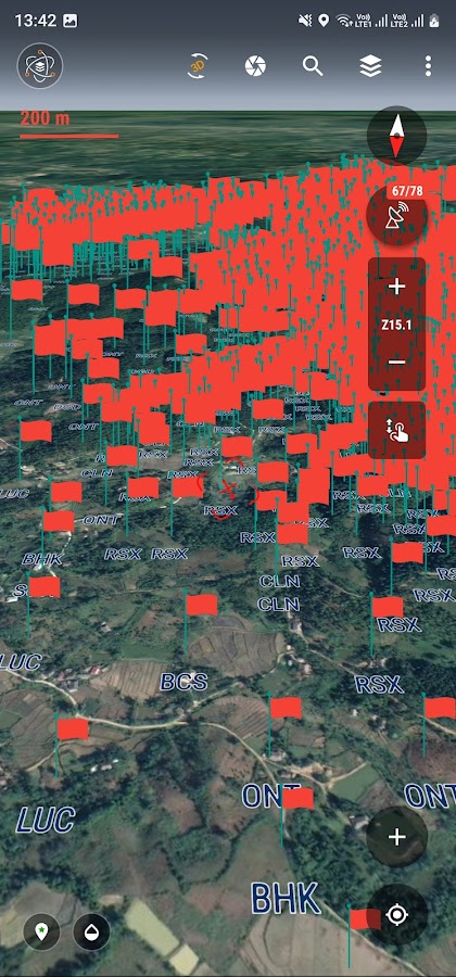
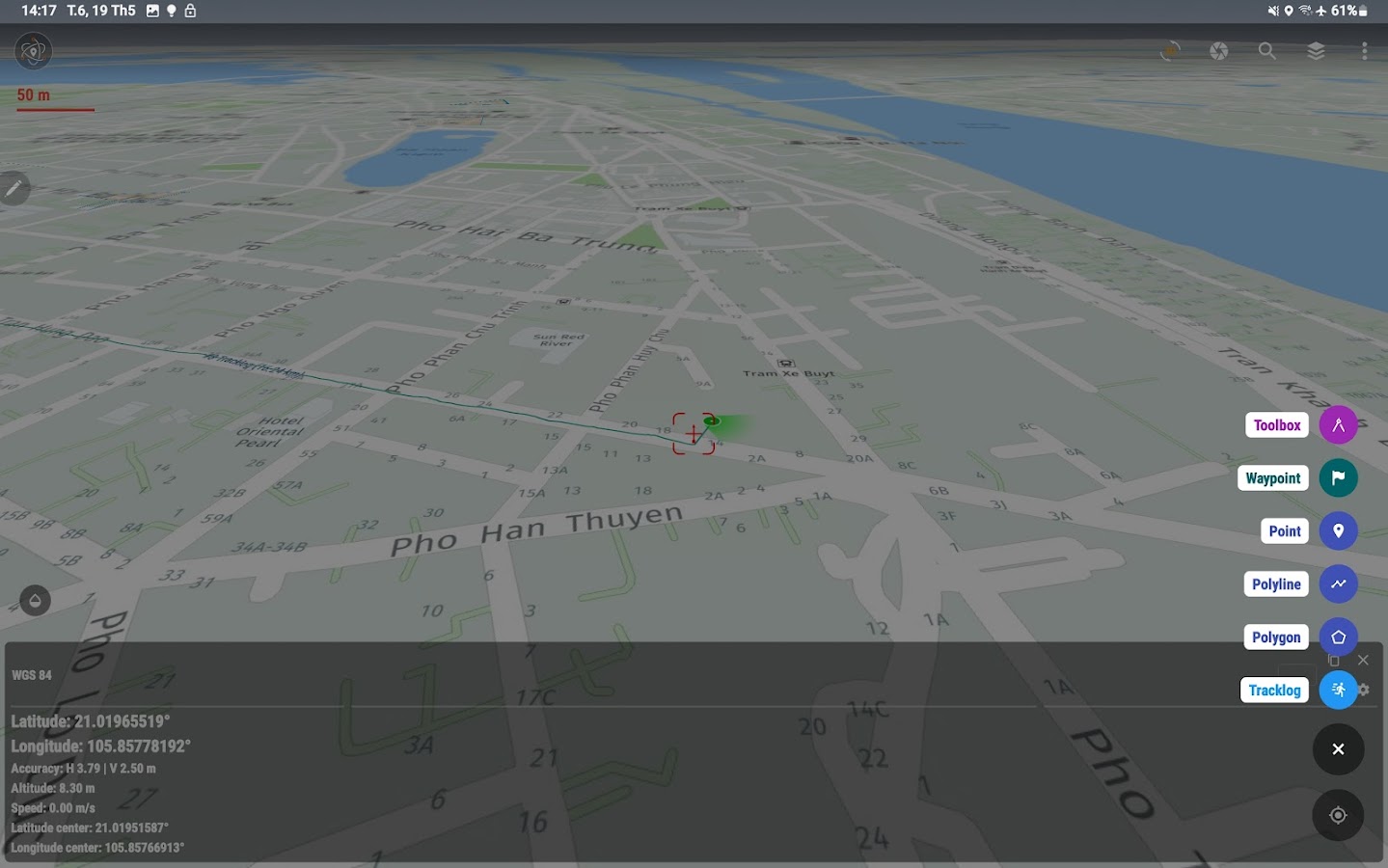
The application makes mapping, management planning and fieldinspection simple, fast and convenient. Fully integrated with thesame functions as a handheld GPS and also adds many new functionsto turn your phone into a powerful tool to support surveys, surveysand planning. Field management is the easiest. The main functionsof the application: - Positioning, current position, practical viewangle in the field. Help identify better directions. - Allows usersto directly create objects (Points, Lines, Zones, Coordinatelandmarks, Tracklog routes). - Allows rapid measurement of the areaand length of objects in the field. - Users can simultaneouslycreate Tracklog, create Point, Road, and Region at the same timewhile moving. Tracklog mode allows running in the background. -Support to save attribute information and images in the field. -Users can define forms, forms or fields to collect. And sharequickly to the whole group via QR code or export to file. - Findfor waypoint, enter a list of waypoints from data TEXT(*.txt),Excel (*.xls, *.xlsx), CSV (*.csv) Excel and convert pointcoordinates directly on the device. - Allow to enter the list ofpoints to check by hand (For example, it is necessary to check thelocation of the extract of the red book). - Support directlyopening common data such as Excel, GPS/GPX, KML/KMZ, GeoJSON,AutoCAD DXF, MicroStation DGN, ESRI Shapefile SHP, MapInfo TAB,gCadas GTP - Support export data to GPX, KML, GeoJSON, Excel,AutoCAD DXF, MapInfo TAB, Shapefile SHP format and share via Email,Drive, Zalo, Facebook etc. - Fully support the VN 2000 projectionsystem of the local and nationwide of Vietnam. - Support more than5000 projection systems of other countries and territories in theworld. - Support for old projection systems like Hanoi 1972 (HN72). - Support numerical compass feature - Support reading offlinemap data MBTiles and intelligent management of data layers. -Support with simple MBTiles convert tool on Desktop, help to viewproperties directly from MBTiles layer. - Support conversion ofTCVN3, VNI encoding for Vietnamese font in viewing attributeinformation. - Support field photography, save location, shootingdirection on images and Exif information, GeoTag - Allow users todownload Google, MapBox, Bing, ESRI, OSM directly on the computerfor offline use. - Support web map service TMS and WMS. - Thefeature allows users to directly find and use Landsat 8 satelliteimage data (16-day update cycle) and Sentinel 2 (5-day updatecycle) from the image database. If you need assistance pleasecontact us at the following information: Facebook:https://www.facebook.com/vToolsForMapInfo Email:[email protected] Phone (Zalo): (+84) 96 990 4596 All RightsReserved. Copyright © 2020
Similar Apps Show More...


Coordinate Master 3.7 APK
This powerful geodesy app allows you toconvert coordinates between many of the world's coordinate systems,compute geoid offsets, and estimate the current or historicmagnetic field for any location. It also includes surveying toolsto compute the point scale factor and grid convergence.The app uses the PROJ4 library and a lookup file containingprojection and datum parameters to support over 1700 coordinatesystems. Lat/lon, UTM, US State Plane, and many, many others aresupported. You can also create your own coordinate systems if youknow the parameters.The app also supports affine transformations toallow you to set up local grid systems. Seehttp://www.binaryearth.net/Miscellaneous/affine.html fordetails.The app either takes manual coordinate input or uses your currentGPS location. The computed location can be displayed in Google Mapsvia your web browser with a single button press. It also supportsMGRS grid references.You can export any lat/lon, UTM or transverse Mercator coordinatesystems to a HandyGPS datum (.hgd) file for use as a custom datumin HandyGPS.The magnetic field calculator page computes the Earth's current orhistorical magnetic field at a given location. The magneticdeclination computed is useful for compass navigation since itrepresents the difference between true north and magnetic north.Field inclination and total intensity are also computed. This tooluses the International Geomagnetic Reference Field model (IGRF-12).See http://www.ngdc.noaa.gov/IAGA/vmod/igrf.html for full details.Years from 1900 through to 2020 are supported.The app can also compute the geoid height offset for a givenlocation, using the EGM96 model. Geoid offset can be subtractedfrom the height reported by GPS to give your actual height abovesea level.Online help for the app is available athttp://www.binaryearth.net/CoordinateMasterHelpNOTE: A version of this app is now also available foriPhones.Permissions required: (1) GPS - to determine your location, (2) SDcard access - to read and write user projections file.


BA Financial Calculator PRO 1.0.8 APK
Emulator of the BAII Plus Professional Calculator. This isthepremium version of the BA financial calculator app. It isad-freeand has the features of the BAII Plus Professional (PB, DPB,DUR,MIRR). This app has been developed by a single person to helpCFAcandidates and charterholders on their way to success. Youcancontact [email protected] for support

Promega Biomath Calculators 1.1.1 APK
Perform everyday lab calculations with asingle app. The Biomath Calculators provide a range of functionsessential to molecular biology experiments, including nucleic acidand protein conversions, melting temperature, temperatureconversion, molarity and dilution calculations.Nucleic Acid Conversions•dsDNA: Micrograms to Picomoles Converter•dsDNA: Picomoles to Micrograms Converter•Oligos (ssDNA): Micrograms per Milliliter to Picomoles perMicroliter Converter•Oligos (ssDNA): Picomoles per Microliter to Micrograms perMilliliter Converter•Linear DNA: Micrograms to Picomoles of Ends Converter•Ligations: Molar Ratio of Insert to Vector Calculator•Absorbance Units of Nucleic Acid to ConcentrationProtein Conversions•Protein Molar Conversions Tool•Coding Capacity of DNA CalculatorCalculators & Additional Conversions•Dilution Calculator•Molarity Calculator•Temperature Conversions Tool•Tm (Melting Temperature) Calculations for Oligos


Lefebure NTRIP Client 2020.04.06 APK
Connect to a high accuracy GPS or GNSSreceiver, stream DGPS or RTK correction data to the receiver viaNTRIP over the phone's Internet connection. Log NMEA position datafrom that receiver to a file on the SD card. Make NMEA positiondata from an external receiver available to other Androidapplications.Note that this application requires the Bluetooth Serial PortProfile to connect to a GPS receiver. Bluetooth SPP is not includedin all Android devices.Permissions Needed:INTERNET - Used for getting correction data from theInternet.BLUETOOTH - Used for connecting to a Bluetooth device.BLUETOOTH_ADMIN - Used for pairing with a Bluetooth device.WRITE_EXTERNAL_STORAGE - Used for writing NMEA data to a text fileon the SD card.ACCESS_MOCK_LOCATION - Used for routing external position data toother applications.ACCESS_FINE_LOCATION - May be used for sending location to NTRIPcaster instead of using data from the external receiver or amanually entered lat/lon.IN_APP_BILLING - Used for the subscription for the premiumfeatures.


