


Description
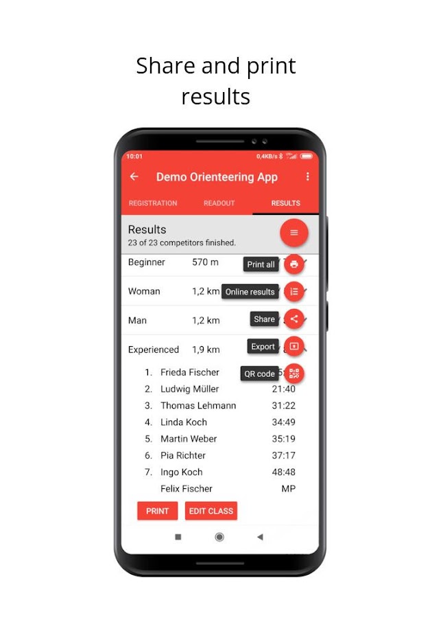
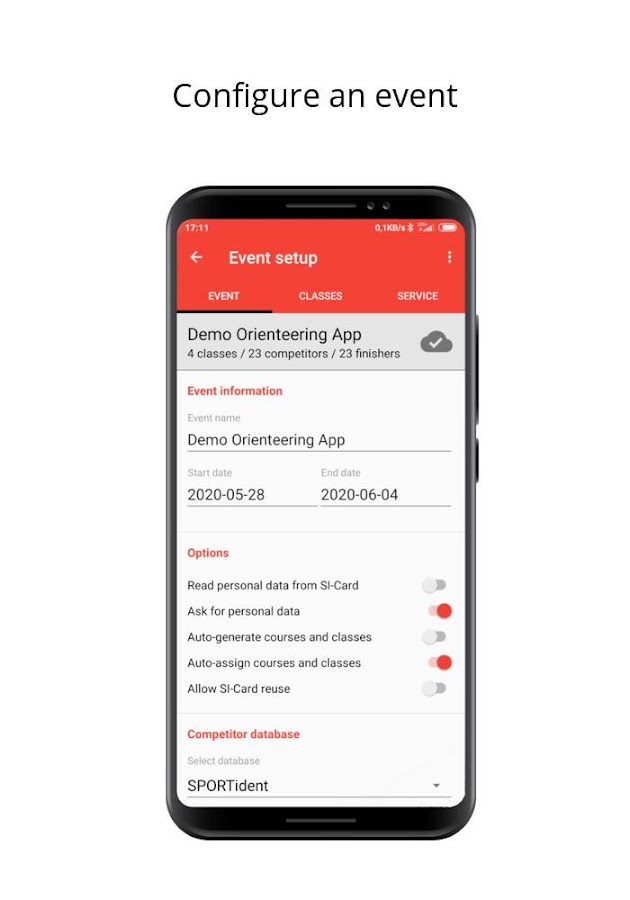
App Information SPORTident Orienteering
- App NameSPORTident Orienteering
- Package Namecom.sportident.apps.orienteering
- UpdatedDec 1, 2021
- File SizeUndefined
- Requires AndroidAndroid 5.0
- Version2021-12-01
- DeveloperSPORTident GmbH
- Installs-
- PriceFree
- Category
- Developer
- Google Play Link
SPORTident GmbH Show More...


Similar Apps Show More...


Topo GPS Spain 6.2.0 APK
Makes from your phone or tablet a complete GPS device with thedetailed topographic map of Spain. Viewed maps will be stored onyour device so that Topo GPS can also be used without an internetconnection. Why should you buy an expensive GPS device if you caninstall Topo GPS on your phone or tablet for only 3,99 €? Topo GPScontains all functions of a regular GPS device for less money, hasa much more detailed map, and is more convenient to operate. Theaccuracy of the position determination is in favorable conditionsabout 5 m. Ideal for walking, hiking, cycling, mountainbiking,horse-riding, geocaching, trail running and other outdooractivities. Also suited for outdoor professionals. Map * Completetopographic map of Spain , newest edition. * Very detailed maps,with buildings, cultivation, all roads including the smallestforest trails, contour lines, and characteristic elements in thelandscape. * Future updates of the map are included for free. * Themap can be zoomed and moved. * All maps of a certain region can bemade offline accessible using the map download screen. * Percentageof map that is offline accessible is indicated on the top left ofthe map. * Map tiles can be stored on external storage, like forexample an SD-card. Intuitive interface * Clear menu with mostimportant functions. * Different dashboard panels with distance,time, speed, altitude and coordinates. * Clear manual atwww.topo-gps.com. Routes * Recording of routes, with pause andrestart possibility. * Planning of routes via route points. *Importing routes in gpx and zipped gpx format. * Editing routes. *Sharing routes. * Free access to route collection Topo GPS. *Searching routes with filters. * Routes can be organized intofolders. * Maps of a route can be made offline accessible.Waypoints * Adding waypoints by pressing on map. * Adding waypointsthrough address or coordinates. * Supported coordinate systems:WGS84 decimal, WGS84 degree minutes (seconds), UTM and MGRS. *Importing waypoints in gpx and zipped gpx format. * Sharingwaypoints. * Editing waypoints. * Photos can be added to waypoints.* Searching waypoints with filters. * Waypoints can be organizedinto folders. Your location * Location and movement directionindicated by arrowed marker. * Displayable in WGS84 decimal, WGS84degree minutes (seconds), UTM and MGRS coordinates. * Sharing andsaving as waypoint. In app purchases * Topographic maps of Belgium,Denmark, Finland, France, Germany, Great Britain, Netherlands,Norway, New Zealand and Sweden. * OpenStreetMap world map. If youare recording a route, the GPS will run in the background.Continued use of GPS running in the background can dramaticallydecrease battery life. Rdzl, the company behind Topo GPS, does notobtain in any way the location of the user of Topo GPS. Rdzl doesnot obtain your routes and waypoints, unless you share a route withTopo GPS. Rdzl does not register which map tiles you havedownloaded. We sell our product, not our user data.

Topo GPS France 7.2.0 APK
Makes from your phone or tablet a complete GPS device with thedetailed topographic map of France. Viewed maps will be stored onyour device so that Topo GPS can also be used without an internetconnection. Why should you buy an expensive GPS device if you caninstall Topo GPS? Topo GPS contains all functions of a regular GPSdevice for less money, has a much more detailed map, and is moreconvenient to operate. The accuracy of the position determinationis in favorable conditions about 5 m. The price of the detailedtopographic map is 0,99 € for four sections of 4 by 4 km. You getlifetime access to purchased sections including future map updates.You can easily select the sections you need on an overview map. Youget a discount if you buy a large section at once. Purchases aremade available on all devices that share the same Google Playaccount. Ideal for walking, hiking, cycling, mountainbiking,horse-riding, geocaching, trail running and other outdooractivities. Also suited for outdoor professionals. Map * Completetopographic map of France, scale 1:25,000 (SCAN25 from IGN), newestedition. * Very detailed maps, with buildings, cultivation, allroads including the smallest forest trails, contour lines, andcharacteristic elements in the landscape. * Future updates of themap are included for free. * The map can be zoomed and moved. * Allmaps of a certain region can be made offline accessible using themap download screen. * Percentage of map that is offline accessibleis indicated on the top left of the map. * Map tiles can be storedon external storage, like for example an SD-card. Intuitiveinterface * Clear menu with most important functions. * Differentdashboard panels with distance, time, speed, altitude andcoordinates. * Clear manual at www.topo-gps.com. Routes * Recordingof routes, with pause and restart possibility. * Planning of routesvia route points. * Importing routes in gpx and zipped gpx format.* Editing routes. * Sharing routes. * Free access to routecollection Topo GPS. * Searching routes with filters. * Routes canbe organized into folders. * Maps of a route can be made offlineaccessible. Waypoints * Adding waypoints by pressing on map. *Adding waypoints through address or coordinates. * Supportedcoordinate systems: WGS84 decimal, WGS84 degree minutes (seconds),UTM, MGRS and Lambert93. * Importing waypoints in gpx and zippedgpx format. * Sharing waypoints. * Editing waypoints. * Photos canbe added to waypoints. * Searching waypoints with filters. *Waypoints can be organized into folders. Your location * Locationand movement direction indicated by arrowed marker. * Displayablein WGS84 decimal, WGS84 degree minutes (seconds), UTM, MGRS andLambert 93 coordinates. * Sharing and saving as waypoint. In apppurchases * Topographic maps of Belgium, Denmark, Finland, France,Germany, Great Britain, Netherlands, Norway, New Zealand andSweden. * OpenStreetMap world map. If you are recording a route,the GPS will run in the background. Continued use of GPS running inthe background can dramatically decrease battery life. Rdzl, thecompany behind Topo GPS, does not obtain in any way the location ofthe user of Topo GPS. Rdzl does not obtain your routes andwaypoints, unless you share a route with Topo GPS. Rdzl does notregister which map tiles you have downloaded. We sell our product,not our user data.


