Top 50 Apps Similar to BarometerNet


Ulysse Speedometer Pro
ULYSSE SPEEDOMETER PRO—the ultimateadvancedGPS tool that is not only a high-precision GPS*Speedometer,displaying not only the current speed (analog ordigital) but alsopacking in many other exciting features.As a part of our Ulysse community, you’ll find itsfunctionalityindispensable. To discover further what’s packed intoour tool,visit:www.binary-toys.chwww.facebook.com/UlysseGpsSpeedometerAt binarytoys Lab, we listen to our users and areconstantlyintegrating your feature requests—Ulysse is not onlybuilt by us,but also by you, our Ulyssers!How about:★ Overlays—display important speed/direction/time info overyourother installed apps★ Trip Computer—record the current, yesterday’s, today’s,week’s,month’s journeys★ Track recorder—trace your journey and export to SD and/or emailasGPX or Google Earth KML format★ Multiple profiles: for every car, bike, velo,walking,skiing★ Music Controller—control your installed musicplayerdirectly★ HUD—a Head-Up Display for your windshield★ GPS Altimeter★ GPS Compass★ Latitude/longitude display★ Settings km/h, mph, knots; miles/feet, kilometers,nauticalmiles★ Maximum displayed speeds: 1900 km/h / 1160 mph / 1000knots!★ Racing meter—measure acceleration times: 0-100 km/h, 0-60 mphandfor 1/4 mile.★ Average speed indicator★ Switchboard – menu system providing easy setting changesoffunctions – simply tap the main speedometer dialforactivation★ Three shortcut pages—Application, Communication, Navigation; foratotal 36 user-defined application shortcuts★ Speed limits’ warnings (‘Speed Edge’) – define audio andvisualspeed alarms★ App quickstart—assign other installed apps and called in justtwotaps★ Customizable UI colors—are 16 million colors enough?★ Current battery status info—charge, temperature★ Car dock support—application automatically starts and exitsondocking and undocking★ Run the speedometer in background mode—show speed discretelyinthe status bar and even gives visual notification forspeedlimits**★ Binarytoys’ Customer support second-to-none… take a look atourreviews!But don’t limit Ulysse to just your automobile!Imagine accessing all the features mentioned via virtually anymeansof transport.Whether traveling by van, truck, bus, motorbike, bike,horse,unicycle, Segway, plane, helicopter, foot, camel, taxi,rickshaw,skateboard, train, boat, hang-gliding or paragliding(etc.)—youwill find a useful use for Ulysse!We Love our Ulyssers – And They Love Ulysse!We are fully dedicated to our user base – with its millions ofloyalworldwide users, we are constantly building on this successtoguarantee that Ulysse remains on pole position now and inthefuture.You don’t have to take our word for it, read what some of thetopnames in the business are saying:"Poetry in motion"—AndroidPit.com"Most advanced Speedometer App"—AppEggs.com"this virtual dashboard has been aprovenlifesaver"—complex.com"...enter Ulysse Speedometer to save me"—RichardDevine,AndroidCentral"Accurate, visually appealing and informativespeedometerapplication"—Crackberry.comHave we forgotten something? Visit our homepage and send usacomment.Would you like to see Ulysse translated into your ownlanguage?Contact us today at [email protected] to find out howor join uson http://crowdin.net/project/ulysse-speedometer*Dependent on phone hardware**In the case of system overloading, a small lag is possibleKnown limitation - trip distance may have 2-3% deviation fromcar'sodometer dataLook to ulysse.ibolt.co for a new car-dock for your phone!


StormTeam8 - WTNH Weather 5.3.703
Never let the weather catch you by surprise again.Thetrustedweather experts at StormTeam8 deliver Connecticut'smostaccuratehour-by-hour forecast for the next day and for theweekahead.Unlike other weather apps, you'll get a local forecastthatiscustomized for you. Download the StormTeam8 app forfast,accuratelocal and national weather at your fingertips. Withitspersonalalert notifications, you'll know when significantweatherisheading your way and when to take cover. And whenyouaretraveling, use StormTeam8 to get real-timeweatherforecasts,interactive radar and current conditions foranywhere inthe U.S.The StormTeam8 app utilizes the most advancedradar maps,weatherand digital technology available. With its easyto useinteractiveradar, you can take control and see where thestorm isnow andwhere it is tracking. Then, set customized alerts tokeepyou andyour family informed and safe. Features: - Liveinteractiveradarwith many layering options lets you track thestorms aroundyou -Alerts for severe weather go to your home screenand cue anaudioalert - The most accurate hour-by-hour forecast forthe nextdayand week ahead for Connecticut - The latest videoforecastfromStormTeam8 - Current weather conditions forConnecticutandanywhere in the United States - Share the weatherconditionsviatext message, email, Facebook or Twitter - You cansetmultiplecustom locations to track forecasts, alerts, radar,andmore -Closings and delays for Connecticut - News andweatherheadlinesfrom WTNH - Live streaming video from WTNH


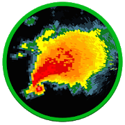
Storm Guard - Weather Radar 1.24
"Storm Guard" is a free application that providesreal-time,early-warning notifications when rain or snow is detectednear yourlocation. This application is the go-to app for weatherdetectionand storm cell analysis! In this application, you willgain accessto: RAIN AND SNOW PROXIMITY ALARM - Storm Guard sendspromptnotifications when any precipitation such as rain or snowentersyour detection area. Open the app to refresh your locationand toanalyze any incoming weather systems. You can also choose toleavethe app open and enable the "follow location" option, whichwillauto-center the map and update your location as you move!Closingor minimizing the app will lock your location in place.-Customizethe detection sensitivity by adjusting the detectionarea, minimumintensity threshold, and notification frequency withintheapplication settings. You can always opt out of notificationsinsettings as well. Storm Guard currently provides rain andsnowproximity detection for continental US locations and partsofCanada. WEATHER SYSTEM AND STORM CELL ANALYSIS -Storm Guardwillscan and place a magenta circle over the most significantweatherwithin the detection area. Click this circle to view thecompletecell analysis including average precipitation intensity,maximumprecipitation intensity, storm area, and distance fromyourlocation. -Analyze weather systems anywhere on the map bypanningand zooming over any visible precipitation radar data.-Viewcomplete details of every cell within the detection area byusingthe weather details inspector (magnifying glass icon inthebottom-left of the map screen). Storm Guard currentlyprovidesweather cell analysis for continental US locations andparts ofCanada. SHORT TERM WEATHER FORECAST -The weather detailsinspectoralso provides a short term forecast for the area. Thisfeaturelists any possible weather phenomena that may be occurringwithinthe next three hours. Pan and zoom around the map to getshort termforecasts anywhere on the map. Storm Guard currentlyprovides shortterm forecasts for continental US locations. WEATHERDATA OVERLAYSWITH LOOPING -Gain access to a variety of weatheroverlays to viewon the map. You can animate (loop) each overlay toget a time lapserepresentation of the data. -Overlays include:Weather RadarInfrared Satellite (Cloud Coverage) 24 HourAccumulatedPrecipitation Surface Temperatures Wind Speeds WindGusts WEATHERSTATION OBSERVATIONS - Get the latest weather reportsfor theobservation station nearest to the map's center point, orpan andzoom around the map to get observations from any METARreportingstation! Check the current temperature, dew point,humidity,weather conditions, wind, and more! Storm Guard providesstationobservation data globally! NATIONAL WEATHER SERVICE ALERTBULLETINS- Get bulletins for any active weather alerts issued bytheNational Weather Service such as severe thunderstormwarnings,winter storm warnings, hurricane warnings, and more. Panand zoomaround the map to get bulletins for other locations(relative tothe map's center point). A red weather icon will appearon the mapwhen any alerts are detected. Click this icon to view alist ofalerts and their bulletin information. Storm Guardcurrentlyprovides weather alert information for US locationsincludingAlaska and Hawaii. Enjoy the app!


WingX Pro7 2.0.4.0
WingX Pro7 requires a $74.95annualsubscription or $199.95 three-year subscription. There is a30-dayFree Period option. The $74.99 Advanced IFR subscriptionenablesshowing your aircraft on an approach chart.● ● ● New - ADS-B Support ● ● ●GPS-Enabled Moving Map● VFR Sectionals, IFR Enroute Low and High, and WACs● Awesome user-defined enroute transparency - this is cool!● Split screen● Track Up● Brightness● Route CDI, ETEs, and ETAs● Knots, MPH, km/h● External Bluetooth GPS support● Display Airport Labels● Display Airport Status including Flight Rules,Visibility,Ceiling, Temperature, Temperature/Dew Point Spread, andDensityAltitude● Select Airports, NavAids and Fixes from Moving Map (NavAidsandFixes are currently limited to those in the route)● Select TFRs and display TFR Information● State BordersADS-B Support● Display GPS, METARs, TAFs, Winds and Temps Aloft, PIREPs,andNOTAM-D● Display ADS-B NEXRAD images on moving map● Display ADS-B TrafficWx Text● Color-coded and decoded METARs, TAFs, winds/temps aloft● Includes Alaska and Hawaii● Calculates METAR Density Altitude and Freezing LevelsRoute Planning● Victor Airways and Jetways● Total and Longer Than Direct distances● Flight Log shows Magnetic Headings, Groundspeed, ETE, FuelBurnusing winds aloftFlight Services - Lockheed Martin● Flight Plans and Weather Briefings use a secure connection● Official and recorded by Lockheed Martin● File on device, view on Lockheed Martin web site(1800wxbrief.com)or vice versa● File, Close, and Cancel flight plans● Route and Area Weather Briefings● Aircraft Manager for auto-fillE6B● TAS● Conversions● Distance-Speed-Time● Pressure/Density Altitude● Winds Aloft● Runway Winds● IFR Climb● Descent RateIntegrated Help System● Built-in mini-manualFollow us on twitter: mobilewingx


Avare External I/O Plugin 4.0.4
This is the free AddOn app for our free Avare aviation GPS&EFBapp. This app currently provides additional freeconnectivitytoAvare, including NMEA compatibility for usingexternaldedicatedADS-B and GPS receivers in Avare via a BluetoothorWiFiconnection, NMEA output to drive autopilots, andconnectionwithXPlane or Flightgear flight simulators. Actualfunctions basedonthis extended connectivity are being added andactivelydeveloped,so you'll want to watch our Forum, Website, andthe PlayStore forupdates. This Avare External I/O Plugin requiresthe freeAvareapp, which should be installed first. You can findAvare onGooglePlay in the list of our free apps under the "Morefromdeveloper"section below. For details on installation andoperationof Avarewith this I/O app and use with specific devices,please seeourwebsite and search our Forum. The basic steps for usewithanexternal GPS or ADS-B receiver are: --Installation onyourAndroiddevice-- - Install Avare - Install this Avare ExternalI/OPluginapp --Setup-- 1. Turn on the external receiver deviceandensurethat it's ready and transmitting data via Bluetooth(orWiFi), in alocation with clear view of the sky and near theAndroiddevice. 2.On your Android device, disable GPS in thesettings(optional ifyou do not want GPS from tablet internal), andensurethatBluetooth (or WiFi) is on. 3. Launch the Avare app,gotoPreferences, and under GPS select where you want togetGPSmessages (e.g. ADS-B or GPS device), then minimize AvareusingHomebutton of Android device. 4. Launch the IO app, andconnectyourAndroid device to the ADSB/GPS device via Bluetooth.5.Minimizethe IO app (like Avare, it will continue runninginbackground). 6.Return to the Avare app and your position willbedisplayed ifavailable and if other Avare settings are correct.NotethatAvare's GPS tab will be blank when using an external GPSinthisway. While all this may look complex, users report thatoncetheinitial setup is done the routine setup and operation issimpleandintuitive. NOTES: *Based on manufacturerandcarrierimplementations, Android devices handle AirplaneModedifferently.If you use Avare in Airplane Mode, theBluetoothtransceiver inyour device may or MAY NOT be active. It'spossiblethat ifBluetooth isn't working on your device after youactivateAirportMode, it may work if you simply turn on Bluetoothagainwhile inAirplane Mode. You could also further investigate howyourdeviceactually handles airplane mode with a free tool suchasAirplaneMode Modifier. *In many locations, little or noADS-Breception maybe available, especially on the ground, so youmayneed to beflying at or above 3,000' AGL to receive ADS-B data.Ifso, you maybe able to receive at least the data from anylong-haulairlinerspassing overhead transmitting ADS-B Out.
WNCT STORM TEAM 9 5.4.700
Never let the weather catch you by surprise again. Thetrustedweather experts at First Alert 9 deliver Greenville,Jacksonville,New Bern, and Washington N.C.'s most accuratehour-by-hour forecastfor the next day and for the week ahead.Unlike other weather apps,you'll get a local forecast that iscustomized for you. Downloadthe WNCT Weather app for fast, accuratelocal and national weatherat your fingertips. With its personalalert notifications, you'llknow when significant weather is headingyour way and when to takecover. And when you are traveling, useWNCT Weather to getreal-time weather forecasts, interactive radarand currentconditions for anywhere in the U.S. The WNCT Weather apputilizesthe most advanced radar maps, weather and digitaltechnologyavailable. With its easy to use interactive radar, youcan takecontrol and see where the storm is now and where it istracking.Then, set customized alerts to keep you and your familyinformedand safe. Features: - Live interactive radar with manylayeringoptions lets you track the storms around you - Alerts forsevereweather go to your home screen and cue an audio alert - Themostaccurate hour-by-hour forecast for the next day and week aheadforGreenville, Jacksonville, New Bern, and Washington N.C. -Thelatest video forecast from First Alert 9 - Currentweatherconditions for Greenville, Jacksonville, New Bern, andWashingtonN.C. and anywhere in the United States - Share theweatherconditions via text message, email, Facebook or Twitter -You canset multiple custom locations to track forecasts, alerts,radar,and more - Weather blog from WNCT 9 First Alert Weather Blog- Newsand weather headlines from WNCT 9 On Your Side


Thunder GPS Speedometer 2.4.10
Thunder Speedometer provides several stylish super carthemedspeedometers using GPS speed, showing data in a tidycleanclustered designs. Suitable for all kinds of vehicles. •Rotateyour device to switch Thunder Speedometer to landscape orportraitwithout any settings. • Swipe to change the dashboardtheme. •Multiple free themes. • Odometer for tracking milage. •Embeddedcompass for navigation. • HUD (Heads Up Display)speedometer. •Speed trip efficiency, based on a 90kph/55mph caroptimum speed.All that with no ads, as we value your safety morethan revenue.


Hurricane Tracker 1.1
After launching on iOS almost 10 years ago, HurricaneTrackerhasfinally made it's way into the Google Play store!Reviewed byCNNas the best Hurricane Tracking app. GOOGLE: "cnn tophurricaneapp"to read the article! Hurricane Tracker is the mostused &mostcomprehensive tracking app available on any platform.WhatmakesHurricane Tracker different from the others in theGooglePlayStore: • Receive push alerts (by region) when a new stormformsorthreatens landfall • 65+ maps/images • In-depthwrittendiscussionsand analysis from our team • Real timeNationalHurricane CenterUpdates (All NHC advisories & maps) •Audiotropical updates •Storm video updates • Custom graphics fromourteam of experts.Exclusive “Alert Level” & “ImpactPotential”maps. Not justbasic NHC info. • Share informationwithfriends/family via email,SMS, Facebook & Twitter •Superdetailed tropical wave/investinformation • Dozens ofsatellites •Much, much more! There is noother Hurricane trackingapp out therethat can match the amount ofinformation you get-weguarantee it.Get the information you needto make informeddecisions. We chargefor our app because it’s notjust an automatedproduct, our team isconstantly creating graphics& writingdetailed discussions tokeep you informed. This isour full time job- keeping you ahead ofthe storms. NOTE*** We donot offer refunds onour app after thestandard Google trialwindow. All sales final.Hurricane Trackercovers The Gulf ofMexico, Caribbean, AtlanticOcean & EasternPacific. Our appalso covers any storms that mayaffect Hawaii. Wedo not coverstorms near Australia and the WesternPacific. CONTACTUS WITH ANYQUESTIONS: Web: www.hurrtracker.comEmail:[email protected]: @hurrtrackerapp (live, realtimeupdates) *HurricaneTracker is an extremely dataintensiveapplication. A WiFi orstrong cellular signal isrecommended for thebest experience.


ZYRTEC® AllergyCast® 6.6.0
Wondering how today’s allergy forecast will affect yourseasonalallergies? Are your seasonal allergies so bad that youalways checkthe pollen count and allergy map before you head out?The Zyrtec®AllergyCast® app helps take some of the guesswork out ofmanagingyour allergies. It uses advanced technology developed byZyrtecallergy experts to predict how your allergy symptoms may makeyoufeel so you can prepare for each day. Personalized PredictionsatYour Fingertips When you first download the app, we’ll provideyouwith the pollen level in your area based on your zip code. Eachdayfor 5 days, you’ll track your symptoms in the app. After 5 daysoftracking, we’ll unlock your personalized symptom predictions.Thisrating, on a scale from Low to Severe, lets you know howyourallergy symptoms should really feel that day. The more youtrack,the smarter and more personalized our predictions become.Inaddition to your daily symptom predictions, you’ll getafresh-looking app that includes these features: - Weatherforecastsand insights for your zip code that updates based on yourcurrentlocation - An enhanced allergy symptom tracker - Allergytrendsbased on your tracked symptoms and treatments - A list of thetopallergens in your area - A 3-day allergy symptom forecast


Agave 1.7.205 Avocado
Agave - ISY app for mobile home automation of Insteon® andZ-Wave®devices. http://forum.universal-devices.com/forum/120-agave/AgaveHome Automation allows for seamless, secure and customizableremoteaccess to your Universal Devices ISY Controller from yourAndroid®smartphone and tablet. Many Insteon® and Z-Wave® devicescan becontrolled through ISY using Agave. If you find one thatisn’tsupported, contact the developer (we’ll need a node dump ofthedevice from an ISY). Agave can control your Elk® M1 HomeSecuritysystem through your ISY. Arm and disarm in all Elk modesincludingstatus of and control of bypass of all of your Elk zones.You canuse all features of Agave without any limitations free for30 days.After trial, there are no additional downloads required;simplypurchase the features that you would like to continue touse.Trials are tracked using your ISY UUID and initial run date.Agaveis actively developed. This means new devices are addedquickly(please contact the developer in the event you have anunrecognizeddevice) and features are added regularly. We discussnew featureson the UDI Forum > Agave subforum. Agave is secure.Your ISYcredentials are encrypted on your device and you canoptionallyconfigure a PIN (per Agave profile) so that anyone usingyourmobile device won’t have access to use Agave. Connections toyourISY can be encrypted using SSL. Agave is customizable. Youcaneasily add favorite devices to a compact home screen view.Wantmore than one home screen? You can add additional profilestoenable more home screens. Have more than one ISY? You canconfigureconnections to more than one ISY. Don’t know what thecrypticdevice names are on your ISY? Device names, control/actionbuttons,and device status can be customized. Agave works with yourfavoriteInsteon devices (requires an Insteon-compatible ISY).Whether youwant to control an Insteon Thermostat, LED light bulb,On/OffSwitch Relay, Dimmer switch, IO Linc Sensor/Relay,TriggerlincOpen/Close sensor, Motion sensor (2420 verified), smokesensor, oran EZFlora/lawn sprinkler, Agave works for you. As newInsteondevices are released, we work to add them quickly to Agave.Agaveworks with most Z-Wave devices (requires a Z-Wave compatibleISY).Door locks(Schlage, Kwikset and Yale verified) ,thermostats,on/off and dimmable switches, MIMOLite sensors, andAeonMultisensors can be controlled through Agave. If you have aZ-Wavedevice that isn’t already added to Agave, we’ll work with youtoget it added quickly (please contact the developer!).ConnectivityAgave can connect to your ISY using any combination ofthefollowing methods in the order you define: 1. Direct Connectionviaprivate home network (local) connection (usually the“primary”connection) 2. Direct Connection via externalnetwork/cellular dataconnection (may require port forwarding onrouter) (often the“secondary” connection) 3. UDI Portal (Requiressubscriptionthrough UDI)

Baron Critical Weather 4.0.801
The Baron Weather WxWorx app has beenupdatedwith a new, faster interface, and renamed toCriticalWeather.The Critical Weather app alerts you to impending weather dangeratlocations like home, work or your kids’ school, so you canprotectyour family by knowing what’s coming—up to 15 minutes beforethestorm arrives. It’s also a great year-round weather app,competewith current conditions, forecasts and an easy-to-useweather mapwith radar, satellite imagery and more.Choose to receive any or all of these alert types:- Special Baron alerts for dangerous storms approaching, as wellas“twisting” storms that may cause tornadoes- National Weather Service storm-based warnings fortornadoes,severe thunderstorms and flash floodsFeatures:- Integrated SAF-T-Net® weather alerts with Baron TornadoIndex(BTI) rankings for up to four locations, including yourcurrentlocation- Current and forecast conditions based on city, zip code oryourcurrent location- Nationwide radar, satellite imagery, temperature and more- Interactive weather map with pan and zoom- National Hurricane Center (NHC) track forecast cones- 3 and 7-day forecasts in both quick-view anddetailedformats- National Weather Service county and storm-based warnings onthemapFEATURING TORNADO PREDICTION WITH THE BARON TORNADO INDEX®The Baron-exclusive alerts are accompanied by a simple1-to-10ranking on the likelihood of a tornado within theapproaching stormcell. Called the Baron Tornado Index (BTI), thisranking is morelocal and accurate than regional alerts.USE THE APP EVERY DAYThe Critical Weather is also a powerful everyday weather app,withnationwide radar, forecasts, satellite imagery, currentconditionsand more. An easy-to-use slider lets you scan through thenext 24hours of forecasted conditions, so you can see what theweatherwill be like at times and locations important to you.***NOTE FOR CURRENT SUBSCRIBERS OF SAF-T-NET TEXT MESSAGES,EMAILSAND VOICE CALLS:To avoid receiving duplicate alerts from the app and yourexistingSAF-T-Net text/email/voice account, please text “stop” to61872, orlog in to your web-based account to disable your currentalerts. Toprevent disruption in service, it is recommended that youconfigurealerts in the app before disabling your original account.You canconfigure your weather notifications in the app by tappingtheCritical Weather logo at the top-left of your app, thentapping“SAF-T-Net Alerts”.