


Description
App Information Nav Trainer Pro for Pilots
- App NameNav Trainer Pro for Pilots
- Package Namecom.pilotscafe.apps.navtrainer
- UpdatedNov 16, 2017
- File SizeUndefined
- Requires AndroidAndroid 4.0.3
- Version3.4.1
- DeveloperFleminger Media
- Installs5K+
- PriceFree
- Categoryinfo_outline</i></button></div>
- Developer3630 Thompson Rd Lake Mary Fl, 32746 USA
- Google Play Link
Fleminger Media Show More...


Nav Trainer Basic 1.2.1 APK
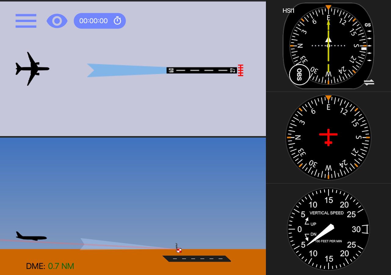
Practice VOR navigation with yourmobiledevice. Nav Trainer Basic is a FREE version of the popularNavTrainer Pro app for instrument pilots.Features:-VOR and heading displays.-Show / Hide radial lines-Fly mode.-Optionally, control the flight with thedevice'saccelerometer.-Wind correction.-Test mode. Very similar to FAA VOR orientation questions. Showsyoua number of airplanes around a VOR station. You have to choosetheright one by adjusting the OBS and reading theinstruments.-Panel can be customize to be on either left or right side ofthescreen (left-handed people may find it more comfortable tochoosethe left panel in the settings).

Similar Apps Show More...


Aviation W&B Calculator 2.3.1 APK
Designed by pilots for pilots. Our main goal is to provide you witha quick and professional way to calculate your aircraft weight andbalance. Note: - This is a 1 month free trial version, which at theend of the trial period you will be offered with subscription plansfor your convenience. - Users of the old app (green logo), pleasebe aware that if you choose to install this update, your data willbe lost and you will be moved to subscription model. Highlights: -Live chat support in-app - Data auto-sync between devices - Enjoy agrowing +100 templates library - iPad landscape & portraitsupport - Metric/US/Mixed units support - Variable fuel arm support- Variable maximum weights support - Save pre-defined weight items- Auto fuel tops on click - Combined stations maximum weight -Summary to meet part 135 requirements - Export and print summary asPDF - Build your own aircraft templates - Professional load sheetsummary - Complex envelope support - Custom station weight units -Unlimited amount of stations Units: US - lbs, Gal, in, qt, ftMetric - Kg, l, m, cm, mm Moment - /100, /1000 Fuel: - Avgas,Mogas, Jet A, Jet A-1 Limitations (all exist in our roadmap): - CGmeasured in length and not %MAC - Helicopters lateral calculations- Up to one variable fuel loading table - No gliders We do our bestto improve our app from update to update, if you have anysuggestions please let us know and we will consider adding them infuture updates. We believe in a quick and professional customerservice, contact us via the chat in the app and we will replywithin one business day. Term of Use: https://bit.ly/2OYxaOtWebsite: https://www.AviationWB.com Facebook:http://www.facebook.com/AviationWB Twitter:https://twitter.com/AviationWB


Aviaze 1.16.1 APK
If you are a pilot, you are in training or you just like to fly andsurf the clouds with your own aircraft Fly Fun, Fly Safe anddownload AVIAZE! AVIAZE is the social network for light aircraftpilots. Use AVIAZE to log your flights and navigate and post yourflights in your timeline. A General Aviation platform where you canshare your flights, thoughts, pictures and come together with acommunity of passionate aviators like you. More than just an airnavigation tool with airspace information, airports, runways andwaypoints, AVIAZE turns your smartphone into a flight tracker and aconnected Flight Data Recorder to monitor, log and broadcast inreal time all flight parameters along your flight route. AVIAZEgathers information from all your device’s sensors to plot allflight parameters. Just like an airliner performance tool, monitorAltitude, Ground Speed, G forces and RPMs estimations to analyzeall inflight events. Monitor the accuracy of your approaches, thesoftness of your landings, the perfection in the maneuvers youexecute, debrief your flights and make every flight hour count toimprove your skills. MAIN FEATURES: - Navigation moving map andairspace information - Share a link with friends and family tofollow your flight in real time - Logbook with automatic block,flight and engine start/stop times detection plus full tracking -Detects take off and landings automatically - Performance graphs(Altitude, Speed, Engine RPMs estimation and Gs) - Flight DataRecorder - Option to post flights in the timeline and share themwith followers - Follow and meet other pilots, like and comment ontheir flights or post - Get points on every flight and positionyourself as a high ranked pilot - Beat challenges and earn badgesWHO IS AVIAZE MENT FOR? Any aviation lover, but especially focusedon General Aviation, ULMs, gliders, paramotors, paragliders andUFOs pilots. A worried flight instructor? a cocky group of friends?a concerned mommy? Let them know where you are at any time. AVIAZEallows you to share your flight in real time via Whatsapp,Instagram, Facebook, Twitter... How does it work? Easy! Start aflight, click on “share” and send them the link that will open theAVIAZE map on their smartphone browser to follow your airnavigation wherever you go. WHAT’S NEXT? Much more is coming, somake sure you invite your pilot friends to share with them flights,adventures, knowledge or anything aircraft related in thisexpanding community of general aviation pilots. Every flight is amission, every pilot has a goal. Safety is always first but, webelieve that flying has to be fun as well. In every flight you willearn points that will allow you to go to the next level and facenew challenges. To start with, beat the 6 first challenges whileimproving your flying skills, share it with AVIAZE community, getlikes and new challenges will come. Ready to have a good time?Welcome to the club!------------------------------------------------ Terms of service:http://aviaze.com/terms-and-conditions-for-the-users.pdf Privacypolicy: http://aviaze.com/privacy-policy.pdf

Airplane Descent Calculator LT 1.3.2 APK
Airplane Descent Calculator Pro $3,99 Suppose you are at 10.000feetand need to descend to 2.000 feet. Where do you begin yourdescent?Airplane Descent Calculator Lite allows you to calculatethedistance in which the plane should begin the descent to gettargetaltitude, for a specific descent rate (vertical speed) andgroundspeed (horizontal speed). Many times during an aircraftflight, trueground speed differs from precomputed ground speed,so, during theflight is necessary to calculate how far we need tobegin thedescent. To avoid needing to go down at 3.000 feet/minutein aCessna 150, to descend from the current altitude to runwayaltitude.This App is Free, has No Ads, and not special permissionsneeded.You can also check Airplane Descent Calculator Pro whichallows to:- Calculate the distance to begin the descent for aspecific descentrate - Calculate the descent rate to get aspecific altitude fromyour current distance - Automatically getcurrent altitude andground speed from GPS NOTE: Application NOTcertified for RealFlight. If you use it, it is at your own risk!!!


