


Description
App Information Mountain Live Explorer - ALPS
- App NameMountain Live Explorer - ALPS
- Package Nameit.gmg.android.mle
- UpdatedAugust 13, 2016
- File Size5.3M
- Requires AndroidAndroid 2.3 and up
- Version2.0.4
- DeveloperUnderground Lab
- Installs1,000 - 5,000
- Price$4.32
- CategoryTravel & Local
- DeveloperEmail [email protected]Italy
- Google Play Link
Underground Lab Show More...


Mountain Live Explorer - ALPS 2.0.4 APK
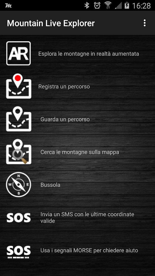
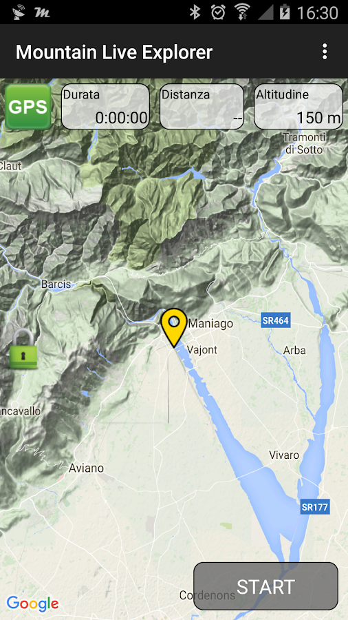
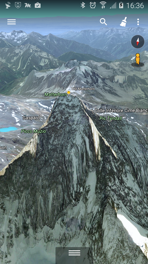
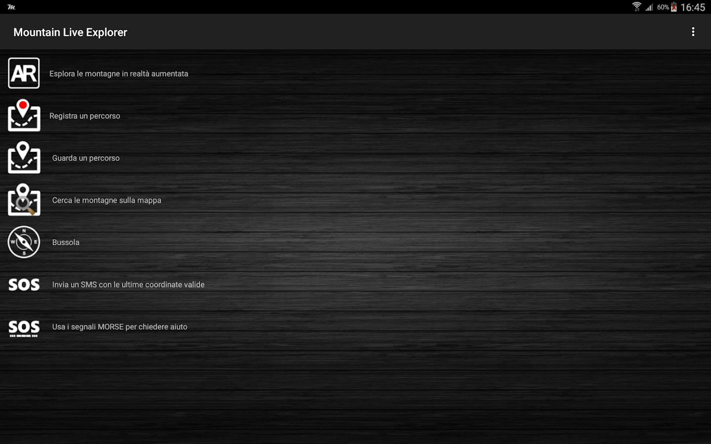
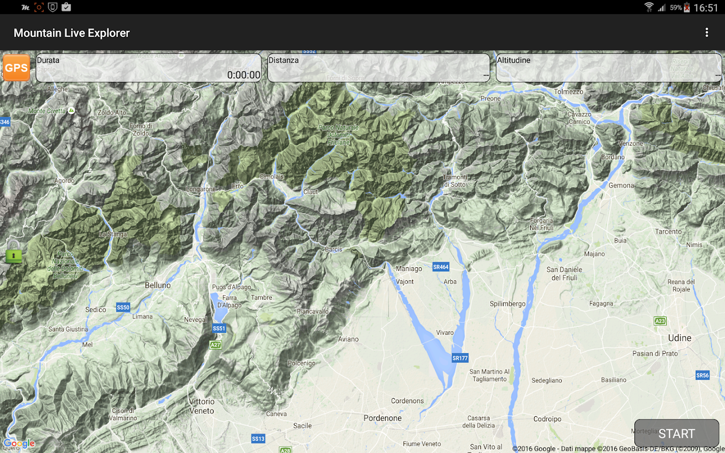
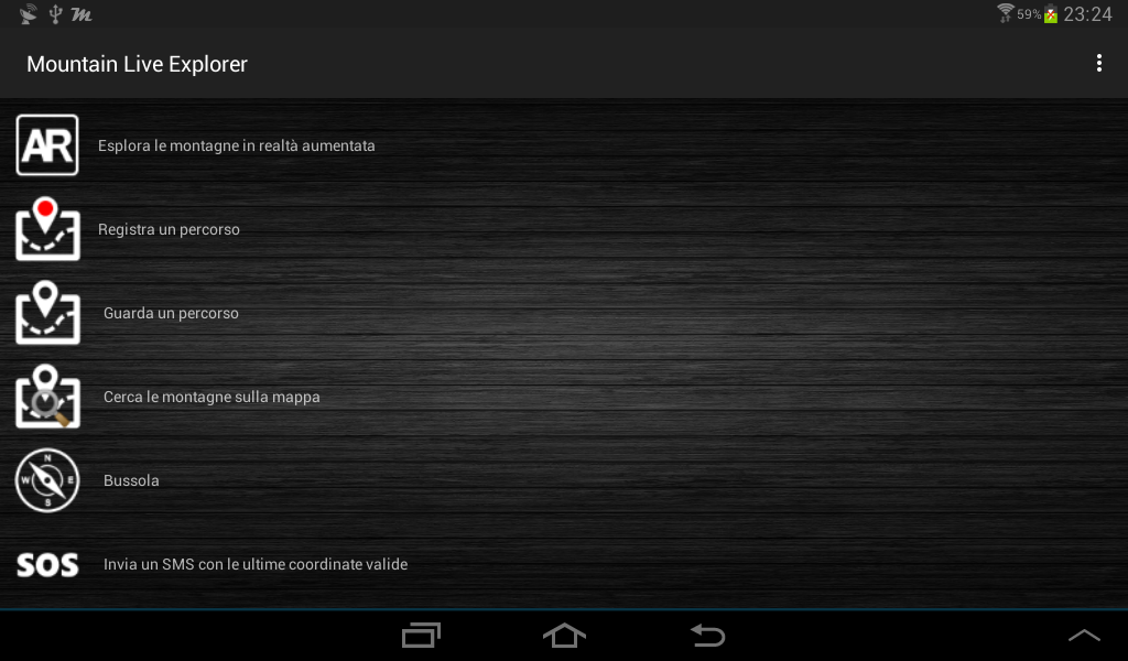
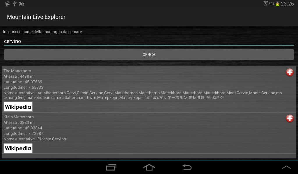
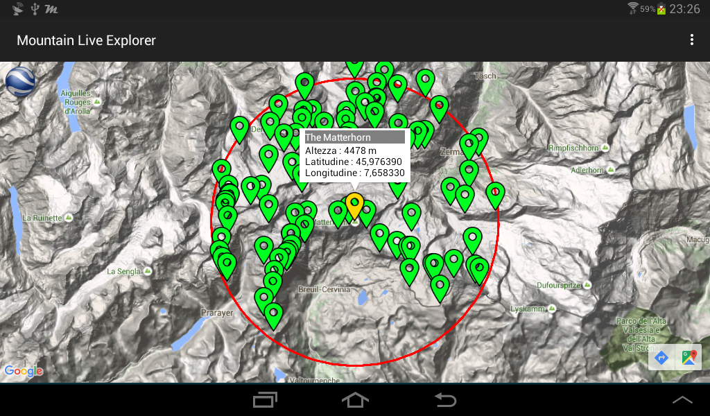
This augmented reality application let youhave information on ITALY, AUSTRIA, GERMANY, FRANCE, SWITZERLANDAND SLOVENIA mountains simply turning your smartphone towards thepeak and enabling the GPS. This application supports Italian andEnglish languages, in the database there are more then 60.000mountains.The main features of the app are:- Augmented Reality exploration- Database browsing- Track recording in GPX format- SOS using light and sms- 3D navigation of all mountains


My Kart Manager 1.0 APK
Supported language: Italian - EnglishThis is an application for your kart! You can take laps time, saveyour cart setup, associate the time and the setuap to a precisetrack. You can calculate the max speed of gear ratio, and take noteabout fuel used for engine maintenace. This is an off-board utilityfor your best sport!

Mountain Live Explorer - USA 1.10.03 APK
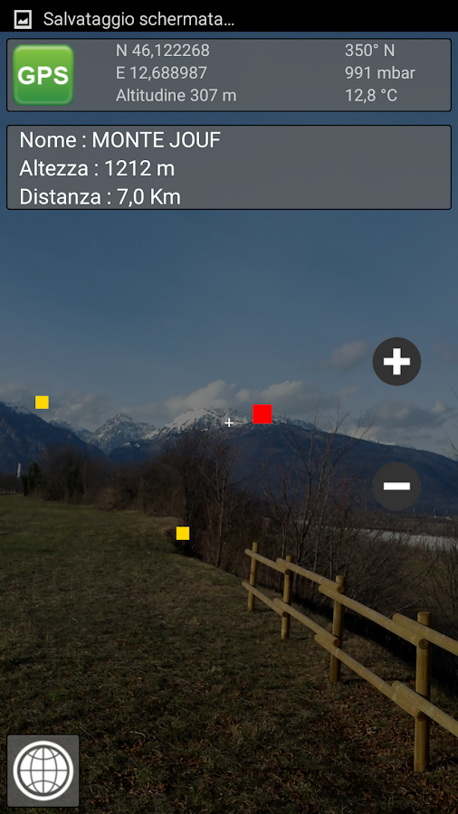
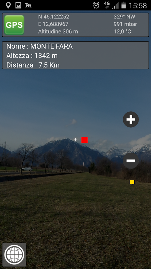
This augmented reality application let youhave information on USA mountains simply turning your smartphonetowards the peak and enabling the GPS. This application supportsItalian and English languages, in the database there are more then225.000 mountains.It is then possible to set a visual distance that let you increaseor decrease the range of mountains to be shown.In every moment it is possible to browse all the mountains databasewith the search menu.Both in search mode and in interactive mode it is possible to enterGoogle Maps and see the peaks that surround you.If an internet connection is available, Google Maps will show youthe map, otherwise you will see a basic visualization with thepeaks position.It is possible to know the distance between your position and themountain selected.The application gives you also useful features for your security: acompass for your orientation, the possibility to send an SOS lightsignal and, if the phone signal is available, an SOS SMS with yourlatest coordinate registered by the GPS.This app is the best to explore mountains, to make trekking, towalk, camping, peakfinder, orientation, Hiking, to explore monumentvalley, grand canyon, rushmore, cruise america, cruiseamerica,rediscover america, rocky mountains, sierra nevada, yosemite,yellowstone, national parks, appalachian, and more. Get itnow!

Mountain Live Himalaya 1.00.01 APK
This augmented reality application, theMountain Live Explorer Himalaya, let you have information onBHUTAN, CINA, INDIA, NEPAL and PAKISTAN mountains (all Himalayamountains like K2, Everest and more) simply turning your smartphonetowards the peak and enabling the GPS. This application supportsItalian and English languages, in the database there are more then25.000 mountains.It is then possible to set a visual distance that let you increaseor decrease the range of mountains to be shown.In every moment it is possible to browse all the mountains databasewith the search menu. You can save your route in GPX format andreview it later.Both in search mode and in interactive mode it is possible to enterGoogle Maps and see the peaks that surround you.If an internet connection is available, Google Maps will show youthe map, otherwise you will see a basic visualization with thepeaks position.It is possible to know the distance between your position and themountain selected.The application gives you also useful features for your security: acompass for your orientation, the possibility to send an SOS lightsignal and, if the phone signal is available, an SOS SMS with yourlatest coordinate registered by the GPS. This app is the best foryou if you visit Himalaya zone.PLEASE NOTE: before leaving a negative feedback, please read theuser guide inside the application, about its correct use or contactthe support with the link in the application menu or sending ane-mail. You will receive all the explanations and the support youneed. The application has been tested with many devices and a lotof mountains and always with very good results. Then, I ask toeveryone who has had a good experience with this application to letme know with a feedback directly in the Android Market webpage,voting with the 1 to 5 stars. Thank you for your cooperation.Follow athttps://play.google.com/store/apps/details?id=it.gmg.android.mlea video of equvalent functionality but of the ALPI edition.

Mountain Live Scandinavia 1.00.03 APK
Mountain Live Explorer Scandinavia is anaugmented reality application that let you have information onFINLAND, SWEDEN and NORWAY mountains and places simply turning yoursmartphone towards the peak. This application supports Italian andEnglish languages, the database has more then 30.000 names ofmountains and places. It's also possible to search in the databasea name of mountain and display it on a map with all the mountainsaround. Using the GPS functionality you can know the distance fromyou and the mountain.The application gives you also useful features for your security: acompass for your orientation, the possibility to send an SOS lightsignal and, if the phone signal is available, an SOS SMS with yourlatest coordinate registered by the GPS.You can record your journeys and see them later on Google Maps andexport to GPX.If an internet connection is available, Google Maps will show youthe map and contour lines(if the zone is covered), otherwise youwill see a basic visualization with the peaks position.Follow athttps://play.google.com/store/apps/details?id=it.gmg.android.mlea video of equvalent functionality but of the ALPI edition.
Similar Apps Show More...


Peak.ar 2.0.6 APK
Somewhere in the universe, eavesdropping adialog between Captain Picard and his crew… "Captain, this isfascinating! This new tool knows the names of the mountains I amlooking at."Experience the intriguing panorama of the peaks surroundingyou.Have you ever wondered "What is the name of that prominent peakover there?” – find the answer simply by taking a look through thecamera of your iPhone or Android device.The advanced segmentation and display algorithms show you allpeak names without obstructing the marvelous panorama.Stagger even the greatest hiking buffs when showing off thefascinating panoramic view this application provides when standingon top of a mountain!This app works on devices with a still camera and amagnetometer/accelerometer.

Peak Search - Alps 1.0.4 APK
Have you ever during mountain hiking, stood onthe pass wondered what is the name of that beautiful peak on theright? Now you can just pull out your phone, launch the applicationand point the camera towards. Peak Search is augmented realityapplication. On the smartphone screen, we see the camera image withaddition informations imposed - points out the name of the placeand the distance to it.Main features:- Designation of few thousand peaks- Handy radar to quickly locate points- Slider to hide distant points- GPS for positioning

Wiener Alpen 1.7.13 APK
Unterwegs am Wiener Alpenbogen, schauen Siesich um!Die neue Wiener Alpen App begleitet Sie durchs „Paradies derBlicke“. Wie ein Abbild des großen europäischen Alpenbogens fächertsich der Wiener Alpenbogen auf. Von der sanften Buckligen Welt überWechsel, Semmering, Rax, Schneeberg bis zur Hohen Wand.Ob Wandern, Rad, Mountainbiken, E-Biken, Langlaufen, Winterwandernoder Schneeschuhwandern. Die App zeigt Ihnen die schönsten Routen.Sie informiert Sie über Weglänge und -beschaffenheit, Höhenprofil,Schwierigkeitsgrad und Kondition. Sie sehen, wo sich die neuenWanderstartplätze und die schönsten Blickplätze befinden. Sieerfahren alles über Hütten, Wirtshäuser, Unterkünfte, Museen undAusflugsziele. Fotos zeigen, wie es vor Ort ausschaut.Alle Karten und Routen sind offline speicherbar. Die App enthältaußerdem einen Gipfelfinder, Kompass, Höhenmesser undHangneigungsmesser, mit dem Sie Ihren Wandertrack aufzeichnenkönnen. Via Communitymodul können Sie sich mit anderen austauschen,über den Zustand der Wege berichten, an Gewinnspielen undFotobewerben teilnehmen.Neu & originell: Besondere Ein- und Ausblicke gewährt der„Wiener Alpen Viewer“. Den verspiegelten Schautrichter gibt es alsStehviewer an Blickplätzen in den Wiener Alpen und als persönlichenHandviewer.Impressum:ARGE – Wiener Alpen Bogen u. Mitgesellschafterp.A. Wiener Alpen in NÖ Tourismus GmbHSchlossstrasse 1, 2801 KatzelsdorfT: +43 / 2622 / 78960E: office(at)wieneralpen.atMove at the Viennese Alpsbow, take a look around! The new Viennese Alps app guides you through the "paradiseof the eyes". As a reflection of the great European Alpine arc fansout at the Vienna Alpine arch. From the gentle hunchback worldabout change, Semmering, Rax, Schneeberg up to Hohe Wand.Whether hiking, cycling, mountain biking, e-biking, cross countryskiing, winter hiking or snowshoeing. The app will show you thebest routes. They inform you of path length and texture, elevationprofile, level of difficulty and condition. You see where the newhiking launch sites and the most beautiful view lots are. Learn allabout cabins, inns, lodging, museums and attractions. Photos showhow it looks on site.All maps and routes are stored offline. The app also includes apeak finder, compass, altimeter and inclinometer, with which youcan record your hiking track. Via community module you can talk toothers, to report on the state of the roads, participate incontests and photo contests.New & original: Special and outlooks granted the "Viennese AlpsViewer". The mirrored Looks judge gives it as a standing Viewer toview places in the Vienna Alps, as a personal hand viewer.Contacts:ARGE - Viennese Alps Bow & co-partnerP. A. Viennese Alps in Lower Tourismus GmbHSchloss Strasse 1, 2801 KatzelsdorfT: +43 / 2622/78960E: office (at) wieneralpen.at

Mountain Navigator 2.6 APK
Paid version of Mountain Navigator withthefollowing extra features:-- No adverts- Height Remaining feature. Tells you how much ascent youhaveleft.- Lakes as well as mountains (Lake District and YorkshireDalesonly).- Copy mountain names to the clipboard, really useful fortexting,Tweeting, Facebook or emails. Let people know where you areat alltimes.- Links to Hill Baggers site for all hills (internetconnectionrequired). Log your ascent from the mountain top!- Links to Mountain Weather Information Service (for supportedareasonly, internet connection required).- Support the developer.Ever stood at the top (or the bottom) of a mountain, staredatthe vast vista of wilderness and wondered what the names ofthemountains were. With Mountain Navigator, all you do is pointyourphone at a mountain and it tells you what it’s called. Thisappdoesn’t need an internet connection to work (chances are youwon’thave one up a mountain anyway).Mountain Navigator uses the British Hills Database v 13.2whichcontains all the hills and mountains in England, Scotland,Irelandand Wales. Allows you to easily set up filters by distancefromyour location, height and classification of mountain(Munro,Corbett and Nuttall etc). Includes Marilyns and Humps sothechances are there’s several hills near you, whereveryoulive.Mountain Navigator has 4 modes:-Viewfinder:Hold the phone sideways, point the camera atthemountain you’re interested in and it displays its name. Tap onthename to get all the details of the mountain and navigatetowardsit.Toposcope: Hold the phone flat and all the hills are shown asatoposcope. The higher the mountain, the brighter the dot. Tap onadot to see its name. Tap on the name to get all the details ofthemountain and navigate towards it.Nearby Hills:Shows all the nearby hills. Tap on the name togetall the details of the mountain and navigate towards it.Search. Search for a specific hill, anywhere in the UKorIreland.Plan. Now you can use any location in the UK withoutactuallybeing there. Allows you to plan in advance of a trip whichhills toclimb and which maps you'll need.Uses the British Hills database, contains all Munros,Corbetts,Grahams, Nuttalls, Marilyns, Wainwrights, Birketts,Humps,Arderins, Vandeleur-Lymans, Sims, Furths and County tops.Ideal for hill walking in The Lake District, the HighlandsofScotland, Ireland, Wales, Dartmoor, the Pennines, theYorkshireDales or anywhere that has hills.
Mountracker 1.3 APK
Con questa app si possono identificare lemontagne che ci circondano tramite la realtà aumentata. E' anchepossibile cercare una vetta per nome e sapere in quale direzione edistanza essa si trovi.Dopo aver inquadrato la vetta che ci interessa, un segnaposto siposizionerà sopra la cima e ci indicherà distanza e altezza. Infineè possibile scattare un'istantanea con tutti i datisovraimpressi.E' presente anche una Google map per avere un'idea della nostraposizione e delle montagne circostanti.Il database contiene più di 2000 vette dell'Appenninocentrale.In caso di errori o imprecisioni, scriveteci persegnalarcelo.Aggiunta la possibilità di caricare e visualizzare file GPX.With this app you canidentify the mountains that surround us through augmented reality.E 'can also look for a peak by name and know in which direction anddistance it is found.After positioning the summit that interests us, a placeholder willbe placed over the top and we will indicate the distance andheight. Finally you can take a snapshot with all overlaydata.It 's also a Google map to get an idea of our location and thesurrounding mountains.The database contains more than 2000 peaks of Central.In the event of errors or inaccuracies, please email us to reportit.Added the ability to upload and view GPX file.
Travel & Local Top Show More...

Flightradar24 - Flight Tracker 6.7.1 APK
Turn your phone or tablet into anairtrafficradar and see planes around the world move in real-timeonadetailed map. Or point your Android device at a plane in theskytofind out where it’s going and more. Discover today whymillionsarealready using Flightradar24 - Flight Tracker.Features that have helped make Flightradar24 - FlightTrackerthe#1 selling app in 100+ countries and the #1 Travel appin140+countries (United States, France, United Kingdom, Germanyandmore)include:* Watch planes move in real-time on detailed map* Identify planes flying overhead by simply pointing yourdeviceatthe sky (the augmented reality view requiresrearcamera,accelerometer & magnetic sensor)* Experience what the pilot of a an aircraft sees in real-timeandin3D* Tap on a plane for comprehensive flight andaircraftinformationsuch as route, estimated time of arrival, actualtime ofdeparture,aircraft type, speed, altitude, andhigh-resolutionpicture* Easy to search for individual flights using flightnumber,airport,or airline* Easy to filter by airline, aircraft, altitude,speed,andmore* Easy to set bookmarks to enable quick navigation toareasofinterest* Turn the device into the arrivals and departures board ofanymajorairport and get real-time status updates for flightspluscurrentairport weather conditions (in-app purchase)* Realistic aircraft symbols (in-app purchase)* Set up custom alerts based on airline, aircraft type,flightnumberor registration (in-app purchase)HOW IT WORKSMost aircraft are equipped with so called ADS-Btranspondersthattransmit positional data. Flightradar24 has arapidlygrowingnetwork of several thousand ground stations aroundthe worldtoreceive this data that then shows up as aircraft movingon a mapinthe app. In an expanding number of regions Flightradar24,withthehelp of multilateration, is able to calculate thepositionsofaircraft that don’t have ADS-B transponders.Traditional radar data is also used in the app thanks toadirectfeed from the US Federal Aviation Administration (FAA).http://www.flightradar24.com/how-it-works***IMPORTANT NOTICES***Minimum required screen resolution is 320x480px.If you are only interested in tracking air traffic inaspecificregion, we suggest that you checkFlightradar24.comBEFOREpurchasing the app. Flightradar24 providesunrivaledpositionalaircraft data coverage around the world butthere areareas wherewe don’t have coverage.Overview of coverage as of January 2016:* Europe: close to 100%* North America: 100% of US and Canada via slightlydelayedradardata. Real-time coverage for most of US, Canada andMexicoforADS-B equipped aircraft* South America: Substantial coverage in mostcountriesincludingArgentina, Bolivia, Brazil, Chile, Colombia,EcuadorandVenezuela.* Asia: Substantial coverage in most major AsiancountriesincludingJapan, India, Indonesia, South Korea, Thailand,UAE,Malaysia,Taiwan and many other countries. Rapidlyexpandingcoverage inChina* Oceania: Nearly complete coverage in AustraliaandNewZealand* Africa: Substantial coverage in Africa with coverageexpandingallthe time.Find out how you can help:http://www.flightradar24.com/increase-coverageCoverage is subject to change at any time.HELP & SUPPORTforum.flightradar24.com/threads/89-Important-Read-this-before-you-ask-questionsflightradar24.com/contact-us.DISCLAIMERThe use of this app is strictly limited toentertainmentpurposes.This specifically excludes activities thatmight endangeryourselfor the lives of others. Under nocircumstances will thedeveloperof this app be held responsible forincidents resultingfrom theuse of the data or its interpretation orits use contraryto thisagreement. We reserve the right toanonymously track andreport auser's activity inside of app.

MOFA KSA 2.5.5 APK
يعد تطبيق وزارة الخارجيةالسعوديةللأجهزةالذكيةهو أحد قنوات الوصول لخدمات الوزارة والتي منخلالهيمكن تنفيذمجموعةمن الخدمات التي تستهدف شرائح مختلفة منالمستفيدين(أفراد،أعمال،وحكومة) كما يتم تحديث التطبيق بشكل دوريبمجموعة منالخدماتالجديدةوالتحسينات التي من شانها رفع مستوى الرضالدىالمستفيدين منخدماتالوزارة.تنفيذ وتطوير التطبيق:تم تطوير التطبيق من قبل الإدارةالعامةلتقنيةالمعلوماتوالاتصالاتالدعم الفني والاقتراحات:يرجى تعبئة الاستبيان الموجود ضمن مشاركاتإلكترونية-استبيانتطبيقالأجهزة الذكية أو مراسلتناعلىالبريدالإلكتروني[email protected]

MakeMyTrip Hotel Extranet 5.0.0 APK
Hoteliers, this one is foryou!MakeMyTrippresents the exclusive Hotel Extranet mobileappspecially designedto keep your hotel details up-to-date.With this app, you can:• Have access to day-wise / calendar view of your hotelrates&inventory• Update your hotel rates & inventory day-wise as well asforalonger period of time• Update ALL your tariffs’ inventory in just 2 steps• Track your important business metrics(likeCheck-InsToday/Tomorrow, Room Night Check-Ins in next 30 days,SoldOut innext 90 days etc.)• Keep a track of all your bookings & also takenecessaryactionslike Confirm a booking, Mark Check-In/No Show fora Pay AtHotelbooking• View complete details of a booking (including the voucher)• Call a Pay At Hotel customer with a single tap• Manage your Hotel Promotions in quick & easy waywithanability to create new promotions• Keep a track of your Payments• View help video tutorials to understand the utilityofourapp• Push Notifications to help you with Sold Out days &summaryofyour BookingsHotel Extranet will set you free from long chain mailsandphonecalls. No matter where you are, you can keep yourhoteldetailsfresh within a few easy steps.Also, there is lot more to come, which will make yourlifeeveneasier!

hottel - Hotel Booking 4.1.20 APK
Everyday hotels give us last-minutediscountsontheir available rooms.Best prices are guaranteed.Hotels are hand-picked to meet your expectation.10 seconds to book a roomPay less enjoy more.8:00 - 24:00 every night we are ready.Contact [email protected]