


Description
App Information Mount Whitney Guide
- App NameMount Whitney Guide
- Package Namecom.highsierraattitude.whitneyguide
- UpdatedApril 6, 2017
- File SizeUndefined
- Requires AndroidAndroid 4.1 and up
- Version6.0.18
- DeveloperAtlasGuides
- Installs100 - 500
- Price$0.99
- CategoryTravel & Local
- Developer
- Google Play Link
AtlasGuides Show More...

The Colorado Trail Hiker 6.0.19 APK
The Colorado Trail Hiker is a smartphone guidefor your Colorado Trail hiking or mountain biking trip.NO CELL OR INTERNET CONNECTION REQUIRED for the app to workon-trail. After initial setup, the app uses your GPS and offlinemaps to guide you along the trail.The free demo is a fully functional version of the app with Segment1 of The Colorado Trail (Miles 0 to 16.8 from the Waterton CanyonTrailhead outside Denver). In-app purchases include (1) TheColorado Trail, which includes the hiking route, the five mountainbike wilderness detours, the Collegiate West Alternative route andthe Collegiate Loop (775.2 miles of trail in total) and (2) astandalone version of the Collegiate Loop route (a 161-mile loopcomposed of the 82.3-mile Collegiate West Alternative route and a78-mile portion of The Colorado Trail).The app has been built in partnership with Jerry Brown of BearCreek Survey Service. Each waypoint in the Colorado Trail Map Book,written by Jerry Brown and offered by The Colorado TrailFoundation, is plotted and described in The Colorado Trail Hikerapp. A portion all proceeds from the sale of The Colorado TrailHiker app will go to The Colorado Trail Foundation.The Colorado Trail Hiker uses a combination of your phone's GPS,downloaded topo maps, and the Google Maps interface to accuratelylocate your position on the trail. No phone service? Not a problem-- your phone's GPS pinpoints your location on top of topo mapsdownloaded as part of the app.A bright red line indicates the location of The Colorado Trail onthe map. Alternate routes are indicated in other colors. Anelevation profile shows trail distance vs elevation and plots yourcurrent location on the trail. Each waypoint is plotted on theprofile. Each waypoint is clickable, opening to the waypoint'sdetail page.The guidebook lists every waypoint in order by distance along thetrail.Each waypoint includes a detail page, providing further detailsabout that particular waypoint. Details include the waypoint'smileage point and elevation, photographs of many of the waypoints,distance to the next trailhead, a Trail Register where you may postcomments and read other users' comments, and other details thatwill help you during your hike, and help you plan your hike.The types of waypoints include:-->Trailheads and parking areas-->Water sources-->Resupply towns/services-->Trail junctions-->Road crossings-->Powerlines, fences, gates, toilets-->Other Landmarks and points of interest

Guthook's John Muir Trail Guide 7.3.4 APK
Please download "Guthook Guides: Hike & Bike Offline" to accessthe John Muir Trail guide. Existing customers may transfer theirpurchases to the Guthook Guides: Hike & Bike Offline app.Guthook's John Muir Trail Guide is a smartphone guide for your hikeon the John Muir Trail. It covers the 210.5 mile John Muir Trailfrom Happy Isles in Yosemite National Park to the summit of Mt.Whitney. It also includes the entire Mt. Whitney Trail (10.4 miletrail from Whitney Portal to Mt. Whitney summit) and many sidetrails. Key features: - No mobile or internet connection isrequired after initial setup -- works in Airplane Mode - Detailedmaps with your GPS location - Elevation profile view - Custom routecreator - Multiple offline map choices - Real-time comments fromother hikers - Send your current location to friends or family viatext message or email The guidebook lists every waypoint in orderby distance along the trail and how far away you are from eachwaypoint. The guidebook also includes a detailed town guide formajor resupply points, towns, and services along the JMT. Waypointdetails include: - Mileage point and elevation - Photographs -Distance to the next water source and tent site - Comments sectionwhere you may post comments and read other hikers’ comments Typesof waypoints: - Water sources (including the reliability of eachwater source) - Detailed resupply and town information: - postoffices and other package services - restaurants - grocery storesand convenience stores - gear shops and hardware stores -laundromats - lodging, public showers, public restrooms - publiclibraries - Tenting sites/camping sites - Trail junctions - Parkingareas along the trail - Picnic areas, campgrounds, ranger stations- Roads, railroad tracks, power lines, fences, gates - Naturallandmarks (e.g. mountain passes) - Privies/restrooms - Views SideTrails: - Baxter Pass - Bear Ridge (to Lake Edison) - Bishop Pass -Blayney Meadows - Cascade Valley/Fish Valley Alternate - CharlotteLake - Darwin Bench - Devils Postpile - Duck Pass - Edison Lake (toferry and to Vermilion Valley Resort) - Evolution CrossingAlternate - Florence Lake Ferry - Half Dome - Isberg Pass Alternate- Kearsarge Pass (to Onion Valley) - Rainbow Falls (at Reds Meadow)- Mist Trail - Mount Whitney Trail - Muir Ranch - Pacific CrestTrail Alternate - Panorama Trail (to Glacier Peak Trailhead) -Piute Pass - Reds Meadow - Sawmill Pass - Shepherd Pass - SunriseLakes/Tenaya Lake Trailhead Resupply Info: - Yosemite Village -Tuolumne Meadows - Lee Vining - Red's Meadow - Mammoth Lakes, CA -Vermillion Valley Resort - Muir Trail Ranch - Bishop, CA -Independence, CA - Lone Pine, CA About the John Muir Trail: TheJohn Muir Trail, or JMT, is revered as one of the most pristine andbeautiful trails in the world. The 210.5 mile trail makes its waythrough the heart of the Sierra Nevada Range in Central California.Much of the trail is above 10,000 feet elevation and is quitesteep, making this a rather difficult trail. Most hikers hike theJMT southbound, beginning at Happy Isles in Yosemite National Park,and ending at the summit of the highest peak in the "lower 48" --Mt. Whitney. It takes about 2-3 weeks to hike the entire trail(some hikers are faster, some are slower). Many hikers complete theentire trail in one go, and countless others enjoy hiking a fewmiles along the trail via the many remote side trails that branchoff the JMT. Also available: Guthook's Pacific Crest Trail GuideGuthook's Tahoe Rim Trail Guide Mount Whitney Guide

Guthook's CDT Guide: Wyoming 6.0.18 APK
**NOTE: THIS APP WILL BE PHASED OUT IN 2018;PLEASE DOWNLOAD THE IDENTICAL APP INFORMATION IN THE ALL-IN-ONE'CONTINENTAL DIVIDE TRAIL' APP BUILT IN PARTNERSHIP WITH THECONTINENTAL DIVIDE TRAIL COALITION**CDT Hiker: Guthook's Guide is a 5-part smartphone guide for yourhike on the Continental Divide Trail. The CDT Wyoming app coversthe 509.8-mile official CDT route in Wyoming from theColorado/Wyoming border to the Wyoming/Idaho border. It alsoincludes these alternate routes: (1) Cirque of the Towers, (2)Knapsack Col, and (3) Leeds Creek Alternate.The app has been built in partnership with Jerry Brown of BearCreek Survey Service. Each waypoint in the Bear Creek map books isplotted and described in the CDT Hiker: Guthook's Guide apps.Guthook's Guide use a combination of your phone's GPS, downloadedtopo maps, and the Google Maps interface to accurately locate yourposition on the trail. No phone service? Not a problem -- yourphone's GPS pinpoints your location on top of topo maps downloadedas part of the app.A bright red line indicates the location of the official CDT on themap. Alternate routes are indicated in blue and accompanied by aseparate list of waypoints and elevation profile. Waypoints ofinterest to the hiker are plotted on the map. There are alsomarkers on the map every mile or kilometer of the trailtrack.The elevation profile shows trail distance vs elevation and plotsyour current location on the trail. Each waypoint is plotted on theprofile. Each waypoints is clickable, opening to the waypoint'sdetail page.The guidebook lists every waypoint in order by distance along thetrail.Each waypoint includes a detail page, providing further detailsabout that particular waypoint. Details include the waypoint'smileage point and elevation, photographs of many of the waypoints,distance northbound and southbound to the next water source, aTrail Register where you may post comments and read other users'comments, and other details that will help you during your hike,and help you plan your hike.The types of waypoints include:-->Water sources-->Towns/post offices/services-->Trail junctions-->Parking areas along the trail-->Campgrounds, ranger stations-->Roads, railroad tracks, power lines, fences, gates-->Other LandmarksAlso available:Guthook's Guide to the Pacific Crest Trail (5-part series)Guthook's Guide to the Appalachian Trail (9-part guide to theAppalachian Trail)John Muir Trail HikerTahoe Rim Trail HikerMt. Whitney GuideVermont's Long Trail HikerTrailblazer's South Downs WayGhost Ranch Guide

Tahoe Rim Trail Guide 7.3.2 APK
Please download "Guthook Guides: Hike & Bike Offline" to accessthe Tahoe Rim Trail guide. Existing customers may transfer theirpurchases to the Guthook Guides: Hike & Bike Offline app. TheTahoe Rim Trail Guide is the official map-based navigational guidefor the Tahoe Rim Trail Association. It maps and lists over 500important hiker waypoints along the 173-mile TRT, such as watersources, tenting sites, road crossings, detailed resupplyinformation, and many more. The free demo for the Tahoe Rim Trailcovers the 20.3-mile Tahoe City North Trailhead to Brockway Summitsection of the Tahoe Rim Trail. Key features: - No mobile orinternet connection is required after initial setup -- works inAirplane Mode - Detailed maps with your GPS location - Elevationprofile view - Custom route creator - Multiple offline map choices- Real-time comments from other hikers - Send your current locationto friends or family via text message or email The guidebook listsevery waypoint in order by distance along the trail and how faraway you are from each waypoint. The guidebook also includes adetailed town guide for major resupply points, towns, and servicesalong the TRT. Waypoint details include: - Mileage point andelevation - Photographs - Distance to the next water source andtent site - Comments section where you may post comments and readother hikers’ comments Types of waypoints: - Water sources(including the reliability of each water source) - Detailedresupply and town information: - post offices and other packageservices - restaurants - grocery stores and convenience stores -gear shops and hardware stores - laundromats - lodging, publicshowers, public restrooms - public libraries - Tentingsites/camping sites - Trail junctions - Parking areas along thetrail - Picnic areas, campgrounds, ranger stations - Roads,railroad tracks, power lines, fences, gates - Natural landmarks(e.g. mountain passes) - Privies/restrooms - Views About the TahoeRim Trail: The Tahoe Rim Trail is a 173-mile trail that circlesbeautiful Lake Tahoe in the Sierra Nevada mountain range. The trailpasses through California (113.5 miles) and Nevada (59.5 miles). 50miles of the trail overlap the Pacific Crest Trail and 31 milesoverlap the Tahoe-Yosemite Trail. The trail is broken into 8sections, ranging from 17 miles to 32 miles each. Many hikerscomplete the entire Tahoe Rim Trail all at once while otherscomplete the trail section by section. Countless others enjoyday-hiking and mountain biking the trail. Tahoe Rim Trail, TRT

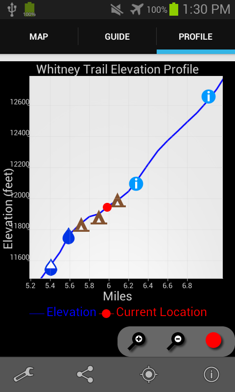
Mount Whitney Guide 6.0.18 APK
The Mt. Whitney Guide is a smartphone guidefor your hike up the Mt. Whitney Trail.Mobile phone service is not available on all but a few feet of theMt. Whitney Trail. But not to worry because the Mt. Whitney Guideapp uses a combination of your phone's GPS, downloaded topo maps,and the Google Maps interface to accurately locate your position onthe trail.The Mt. Whitney Guide takes the guess work out of wondering howmuch farther you have to go, and more importantly, whether you arestill on the trail. A bright red line indicates the location of themain trail on the map. Side trails are indicated in blue. Waypointsof interest to the hiker are plotted on the map. There are alsomarkers on the map every mile or kilometer of the trailtrack.The elevation profile shows trail distance vs elevation and plotsyour current location on the trail. Each waypoint is plotted on theprofile. Each waypoints is clickable, opening to the waypoint'sdetail page.The guidebook lists every waypoint in order by distance along thetrail.Each waypoint includes a detail page, providing further detailsabout that particular waypoint. Details include the waypoint'smileage point and elevation, photographs of the waypoint, distancenorthbound and southbound to the next water source, a TrailRegister where you may post comments and read other users'comments, and other details that will help you during your hike,and help you plan your hike.Types of waypoints include:-->Water sources (including reliability of each watersource)-->Campsites-->Trail junctions-->Information/landmarks-->ViewsAbout the Mt. Whitney Trail: The Mt. Whitney Trail is the mostpopular route to the top of Mt. Whitney, the highest point in theLower 48 United States, at 14,505 feet (4,421 m). Located outsideof Lone Pine, California, in the heart of the Sierra Nevadamountain range, the Mt. Whitney Trail connects to the 212-mile JohnMuir Trail, which in turn connects to the 2,660-mile Pacific CrestTrail. From the Mt. Whitney Trail trailhead to the top of Mt.Whitney is 10.4 miles (16.7 km) with an elevation gain of 6056 feet(1846 m). Many hike to the top and back in one day, while manyothers spend one or two nights on the trail.Also available:Guthook's PCT Guide (5-part guide to the Pacific Crest Trail)Guthook's John Muir Trail GuideTahoe Rim Trail Hiker

The Florida Trail Guide 7.3.2 APK
Please download "Guthook Guides: Hike & Bike Offline" to accessthe Florida Trail guide. Existing customers may transfer theirpurchases to the Guthook Guides: Hike & Bike Offline app.Information in this app is based on “The Florida Trail Guide” bySandra Friend and John Keatley. The Florida Trail Guide is adetailed, map-based smartphone guide for your hike on the FloridaTrail. It lists important hiker waypoints on the FT such as watersources, shelters, tenting sites, road crossings, resupplylocations, and may others. The free demo covers the 42.3-mileBlackwater route from the Florida-Alabama border to Harold. In-apppurchases include guides for: - South Florida - Ocean to Lake Trail- Central Florida - Central Florida West - Ocala Northeast -Suwannee & Big Bend - Eastern Panhandle - Western Panhandle -Blackwater Key features: - No mobile or internet connection isrequired after initial setup -- works in Airplane Mode - Detailedmaps with your GPS location - Elevation profile view - Custom routecreator - Multiple offline map choices - Real-time comments fromother hikers - Send your current location to friends or family viatext message or email The guidebook lists every waypoint in orderby distance along the trail and how far away you are from eachwaypoint. The guidebook also includes a detailed town guide formajor resupply points, towns, and services along the Florida Trail.Waypoint details include: - Mileage point and elevation -Photographs - Distance to the next water source and tent site -Comments section where you may post comments and read other hikers’comments Types of waypoints: - Water sources (including thereliability of each water source) - Detailed resupply and towninformation: - post offices and other package services -restaurants - grocery stores and convenience stores - gear shopsand hardware stores - laundromats - lodging, public showers, publicrestrooms - public libraries - Tenting sites/camping sites - Trailjunctions - Parking areas along the trail - Picnic areas,campgrounds, ranger stations - Roads, railroad tracks, power lines,fences, gates - Natural landmarks (e.g. mountain passes) -Privies/restrooms - Views

Mammoth Tracks - Ice Age Trail 7.3.2 APK
Please download "Guthook Guides: Hike & Bike Offline" to accessthe Ice Age Trail guide. Existing customers may transfer theirpurchases to the Guthook Guides: Hike & Bike Offline app.Mammoth Tracks is the official app for the Ice Age National ScenicTrail, built through a collaboration of the Ice Age Trail Allianceand the creators of Guthook's Guides hiking guide apps. The MammothTracks app is a GPS- and map-based guide for your Ice Age Trailhiking experience. Whether you're backpacking, or in search ofIATA's Cold Caches, this app will help you plan your trip and checkyour location on the trail. Key features: - No mobile or internetconnection is required after initial setup -- works in AirplaneMode - Detailed maps with your GPS location - Elevation profileview - Custom route creator - Multiple offline map choices -Real-time comments from other hikers - Send your current locationto friends or family via text message or email The guidebook listsevery waypoint in order by distance along the trail and how faraway you are from each waypoint. The guidebook also includes adetailed town guide for major resupply points, towns, and servicesalong the Ice Age Trail. Waypoint details include: - Mileage pointand elevation - Photographs - Distance to the next water source andtent site - Comments section where you may post comments and readother hikers’ comments Types of waypoints: - Water sources(including the reliability of each water source) - Detailedresupply and town information: - post offices and other packageservices - restaurants - grocery stores and convenience stores -gear shops and hardware stores - laundromats - lodging, publicshowers, public restrooms - public libraries - Tentingsites/camping sites - Trail junctions - Parking areas along thetrail - Picnic areas, campgrounds, ranger stations - Roads,railroad tracks, power lines, fences, gates - Natural landmarks(e.g. mountain passes) - Privies/restrooms - Views

Arkansas Hiker 7.3.3 APK
Please download "Guthook Guides: Hike & Bike Offline" to accessArkansas Hiker trail guides. Existing customers may transfer theirpurchases to the Guthook Guides: Hike & Bike Offline app.Arkansas Hiker is a detailed, map-based smartphone guide toArkansas' best trails. It maps and lists hundreds of importanthiker waypoints such as water sources, tenting sites, roadcrossings, detailed resupply information, and many more. The freedemo covers the Pinnacle Mountain State Park trail system, alongwith 20 miles of the eastern end of the Ouachita Trail. In-apppurchases include guides for: - Ouachita National Recreation Trail- Eagle Rock Loop - Buffalo River Trail - Pinnacle Mountain - OzarkHighlands Trail Key features: - No mobile or internet connection isrequired after initial setup -- works in Airplane Mode - Detailedmaps with your GPS location - Elevation profile view - Custom routecreator - Multiple offline map choices - Real-time comments fromother hikers - Send your current location to friends or family viatext message or email The guidebook lists every waypoint in orderby distance along the trail and how far away you are from eachwaypoint. The guidebook also includes a detailed town guide formajor resupply points, towns, and services along each trail.Waypoint details include: - Mileage point and elevation -Photographs - Distance to the next water source and tent site -Comments section where you may post comments and read other hikers’comments Types of waypoints: - Water sources (including thereliability of each water source) - Detailed resupply and towninformation: - post offices and other package services -restaurants - grocery stores and convenience stores - gear shopsand hardware stores - laundromats - lodging, public showers, publicrestrooms - public libraries - Tenting sites/camping sites - Trailjunctions - Parking areas along the trail - Picnic areas,campgrounds, ranger stations - Roads, railroad tracks, power lines,fences, gates - Natural landmarks (e.g. mountain passes) -Privies/restrooms - Views
Similar Apps Show More...

Halfmile's PCT 1.3.1 APK
Halfmile’s PCT is a companion smartphone app for Halfmile'sPacificCrest Trail printed maps to aid navigation on the PacificCrestTrail. The app uses your smartphone GPS to determine yourexactlocation, if you are on the PCT or one of its side trails, anditcalculates distances to over 3,000 PCT landmarks. The appalsocalculates elevation gains and losses to landmarks. Halfmile'sPCTapp is available for both iPhone and Android smartphones. Theappdoes not contain maps of the Pacific Crest Trail -- think of itasa very accurate, location aware, digital PCT Data Book.Otherfeatures of the app include: * Works without cell phoneservice *Download and Go -- no extra configuration or data needed*Simulation mode for hike planning and hiker support *Providesspecific "how to walk there" instructions for all points*Calculates cumulative elevation gains and losses to all points*Powerful search function for features like watersources,campsites, and resupply locations * Calculates whichprinted mappages contain your location * Matches the data andcalculations ofthe iPhone edition exactly The Pacific Crest Trailis a 2,650 mileNational Scenic Trail that runs from Mexico toCanada throughCalifornia, Oregon and Washington.

Guthook's Pacific Crest Trail Guide 8.3.8 APK
Please download "Guthook Guides: Hike & Bike Offline" to accessthe Pacific Crest Trail guide. Existing customers may transfertheir purchases to the Guthook Guides: Hike & Bike Offline app.Guthook's Guide to the Pacific Crest Trail is a detailed, map-based5-part smartphone guide for your hike on the Pacific Crest NationalScenic Trail. It maps and lists 4,524 important hiker waypointssuch as water sources, tenting sites, road crossings, detailedresupply information, and many more. The free demo for the PacificCrest Trail covers the 43 mile portion in Southern California fromthe U.S./Mexico Border to Mt. Laguna. In-app purchases includeguides for: - PCT: Southern California - PCT: Central California(Sierra) - PCT: Northern California - PCT: Oregon - PCT: Washington- John Muir Trail - Mount Whitney Trail - Wonderland Trail Keyfeatures: - No mobile or internet connection is required afterinitial setup -- works in Airplane Mode - Detailed maps with yourGPS location - Elevation profile view - Custom route creator -Multiple offline map choices - Real-time comments from other hikers- Send your current location to friends or family via text messageor email The guidebook lists every waypoint in order by distancealong the trail and how far away you are from each waypoint. Theguidebook also includes a detailed town guide for major resupplypoints, towns, and services along the PCT. Waypoint detailsinclude: - Mileage point and elevation - Photographs - Distance tothe next water source and tent site - Comments section where youmay post comments and read other hikers’ comments Types ofwaypoints: - Water sources (including the reliability of each watersource) - Detailed resupply and town information: - post officesand other package services - restaurants - grocery stores andconvenience stores - gear shops and hardware stores - laundromats -lodging, public showers, public restrooms - public libraries -Tenting sites/camping sites - Trail junctions - Parking areas alongthe trail - Picnic areas, campgrounds, ranger stations - Roads,railroad tracks, power lines, fences, gates - Natural landmarks(e.g. mountain passes) - Privies/restrooms - Views About thePacific Crest Trail: The Pacific Crest Trail, or PCT, is thelongest completed trail in the world at 2,650 miles. The trailbegins at the U.S./Mexico border near Campo, California, and windsits way through California, Oregon, and Washington to its northernterminus at the U.S./Canada border near Manning Park in BritishColumbia, Canada. Many hikers complete the entire trail in just oneseason ( a.k.a. "thru-hikers"), and countless others enjoy hikinganywhere from a few miles to hundreds of miles each year.

HikerBot 0.82.29 APK
HikerBot is the ultimate all-in-one app for long-distance trails,created by former and current thru-hikers. Hikers, trail angels,volunteers, trail-side businesses, friends and family, futurehikers, or arm-chair hikers and trail enthusiasts will all findsomething useful. For Hikers: • Most up-to-date trail and town datacrowdsourced by thousands of hikers. See water reports, snowconditions, stream crossing water levels, trail angel listings, busschedules, restaurant and lodging reviews, and more. • Any user canadd waypoints, photos, comments, update descriptions, and edit anycontent in the app, in real time. Think Wikipedia! All data belongsto the community and is not copyrighted. • Download topo maps, roadmaps, and satellite images for offline use. • Navigate using GPSwhile in Airplane mode. Everything in the app works while offline,after the initial data download. • View elevation profiles andcompute distances to locations along the trail. • Order a resupplybox (food, gear, maps, and miscellaneous items) shipped to anylocation on the trail. Browse our store and queue up multipleresupply orders from your tent, even while offline! Checkout whenyou are ready. • Share your location (optional) and see whereothers are on the trail. • See a real-time feed of contributionsother hikers are making. • Search the map by name or point type,search the activity feed by hiker name, location, or type of edit.For Trail-side Businesses: • Create a free listing for yourbusiness with information you'd like hikers to know. For TrailAngels: • If you are interested in helping hikers you can list yourcontact information and what you can provide (transportation,accommodations, help for injured hikers, etc). Inform hikers of anyspecific rules and set expectations. For Friends and Family: •Track the location of your hiker on the trail. • Send a gift cardhikers can use in our store. For Trail Maintenance Crews and LandManagement Agencies: • See real-time hikers reports of traildamage, blowdowns, and infrastructure maintenance needs (e.g.,washed out bridges). For Future Hikers and Trail Enthusiasts: •Explore and learn about the trail. See current photos, use thewealth of information and hiker reports to plan your hike andresupply stops. The following trails are included: Pacific CrestTrail (PCT), Appalachian Trail (AT), Continental Divide Trail(CDT), John Muir Trail (JMT), Sierra High Route (SHR), WonderlandTrail (WT), Great Divide Mountain Bike Route (GDMBR), ContinentalDivide Singletrack Trail (CDST), Hayduke Trail, Arizona Trail(AZT), Pacific Coast Trail.
Travel & Local Top Show More...

Flightradar24 - Flight Tracker 6.7.1 APK
Turn your phone or tablet into anairtrafficradar and see planes around the world move in real-timeonadetailed map. Or point your Android device at a plane in theskytofind out where it’s going and more. Discover today whymillionsarealready using Flightradar24 - Flight Tracker.Features that have helped make Flightradar24 - FlightTrackerthe#1 selling app in 100+ countries and the #1 Travel appin140+countries (United States, France, United Kingdom, Germanyandmore)include:* Watch planes move in real-time on detailed map* Identify planes flying overhead by simply pointing yourdeviceatthe sky (the augmented reality view requiresrearcamera,accelerometer & magnetic sensor)* Experience what the pilot of a an aircraft sees in real-timeandin3D* Tap on a plane for comprehensive flight andaircraftinformationsuch as route, estimated time of arrival, actualtime ofdeparture,aircraft type, speed, altitude, andhigh-resolutionpicture* Easy to search for individual flights using flightnumber,airport,or airline* Easy to filter by airline, aircraft, altitude,speed,andmore* Easy to set bookmarks to enable quick navigation toareasofinterest* Turn the device into the arrivals and departures board ofanymajorairport and get real-time status updates for flightspluscurrentairport weather conditions (in-app purchase)* Realistic aircraft symbols (in-app purchase)* Set up custom alerts based on airline, aircraft type,flightnumberor registration (in-app purchase)HOW IT WORKSMost aircraft are equipped with so called ADS-Btranspondersthattransmit positional data. Flightradar24 has arapidlygrowingnetwork of several thousand ground stations aroundthe worldtoreceive this data that then shows up as aircraft movingon a mapinthe app. In an expanding number of regions Flightradar24,withthehelp of multilateration, is able to calculate thepositionsofaircraft that don’t have ADS-B transponders.Traditional radar data is also used in the app thanks toadirectfeed from the US Federal Aviation Administration (FAA).http://www.flightradar24.com/how-it-works***IMPORTANT NOTICES***Minimum required screen resolution is 320x480px.If you are only interested in tracking air traffic inaspecificregion, we suggest that you checkFlightradar24.comBEFOREpurchasing the app. Flightradar24 providesunrivaledpositionalaircraft data coverage around the world butthere areareas wherewe don’t have coverage.Overview of coverage as of January 2016:* Europe: close to 100%* North America: 100% of US and Canada via slightlydelayedradardata. Real-time coverage for most of US, Canada andMexicoforADS-B equipped aircraft* South America: Substantial coverage in mostcountriesincludingArgentina, Bolivia, Brazil, Chile, Colombia,EcuadorandVenezuela.* Asia: Substantial coverage in most major AsiancountriesincludingJapan, India, Indonesia, South Korea, Thailand,UAE,Malaysia,Taiwan and many other countries. Rapidlyexpandingcoverage inChina* Oceania: Nearly complete coverage in AustraliaandNewZealand* Africa: Substantial coverage in Africa with coverageexpandingallthe time.Find out how you can help:http://www.flightradar24.com/increase-coverageCoverage is subject to change at any time.HELP & SUPPORTforum.flightradar24.com/threads/89-Important-Read-this-before-you-ask-questionsflightradar24.com/contact-us.DISCLAIMERThe use of this app is strictly limited toentertainmentpurposes.This specifically excludes activities thatmight endangeryourselfor the lives of others. Under nocircumstances will thedeveloperof this app be held responsible forincidents resultingfrom theuse of the data or its interpretation orits use contraryto thisagreement. We reserve the right toanonymously track andreport auser's activity inside of app.

MOFA KSA 2.5.5 APK
يعد تطبيق وزارة الخارجيةالسعوديةللأجهزةالذكيةهو أحد قنوات الوصول لخدمات الوزارة والتي منخلالهيمكن تنفيذمجموعةمن الخدمات التي تستهدف شرائح مختلفة منالمستفيدين(أفراد،أعمال،وحكومة) كما يتم تحديث التطبيق بشكل دوريبمجموعة منالخدماتالجديدةوالتحسينات التي من شانها رفع مستوى الرضالدىالمستفيدين منخدماتالوزارة.تنفيذ وتطوير التطبيق:تم تطوير التطبيق من قبل الإدارةالعامةلتقنيةالمعلوماتوالاتصالاتالدعم الفني والاقتراحات:يرجى تعبئة الاستبيان الموجود ضمن مشاركاتإلكترونية-استبيانتطبيقالأجهزة الذكية أو مراسلتناعلىالبريدالإلكتروني[email protected]

MakeMyTrip Hotel Extranet 5.0.0 APK
Hoteliers, this one is foryou!MakeMyTrippresents the exclusive Hotel Extranet mobileappspecially designedto keep your hotel details up-to-date.With this app, you can:• Have access to day-wise / calendar view of your hotelrates&inventory• Update your hotel rates & inventory day-wise as well asforalonger period of time• Update ALL your tariffs’ inventory in just 2 steps• Track your important business metrics(likeCheck-InsToday/Tomorrow, Room Night Check-Ins in next 30 days,SoldOut innext 90 days etc.)• Keep a track of all your bookings & also takenecessaryactionslike Confirm a booking, Mark Check-In/No Show fora Pay AtHotelbooking• View complete details of a booking (including the voucher)• Call a Pay At Hotel customer with a single tap• Manage your Hotel Promotions in quick & easy waywithanability to create new promotions• Keep a track of your Payments• View help video tutorials to understand the utilityofourapp• Push Notifications to help you with Sold Out days &summaryofyour BookingsHotel Extranet will set you free from long chain mailsandphonecalls. No matter where you are, you can keep yourhoteldetailsfresh within a few easy steps.Also, there is lot more to come, which will make yourlifeeveneasier!

hottel - Hotel Booking 4.1.20 APK
Everyday hotels give us last-minutediscountsontheir available rooms.Best prices are guaranteed.Hotels are hand-picked to meet your expectation.10 seconds to book a roomPay less enjoy more.8:00 - 24:00 every night we are ready.Contact [email protected]