

Description
App Information GeoCam
- App NameGeoCam
- Package Nameru.sitis.android.geocam
- UpdatedJune 10, 2013
- File Size13M
- Requires AndroidAndroid 2.1 and up
- Version2.10.1316
- DeveloperSITIS
- Installs50,000 - 100,000
- PriceFree
- CategoryPhotography
- Developer
- Google Play Link
SITIS Show More...

GeoCam Camera Pro 2.10.1317 APK
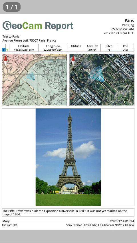
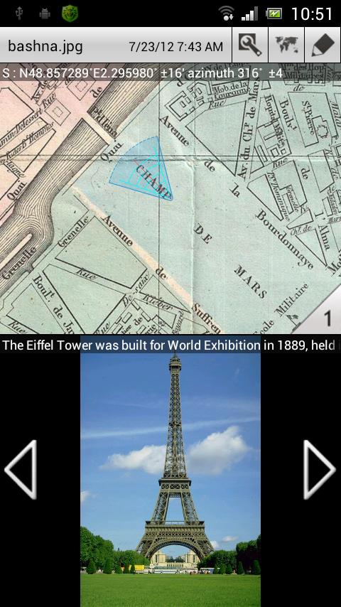
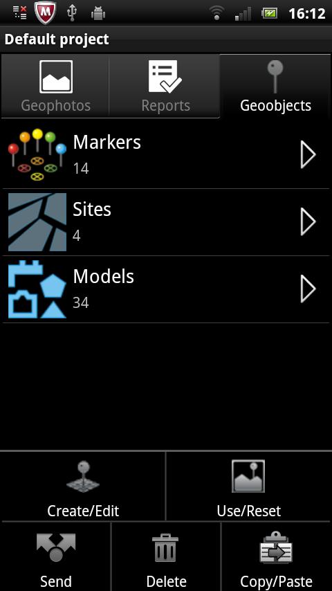
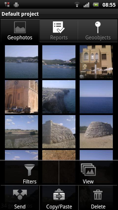
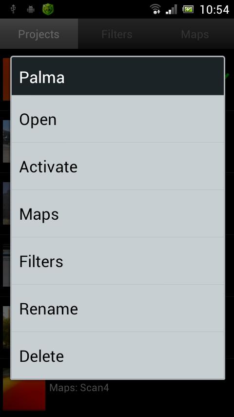
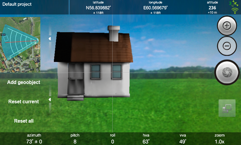
GeoCam Pro is a powerful camera andreportingtool designed to create and preview of geophotos – i.e.photossupplied with geospatial l information, such asgeographiccoordinates, camera orientation at the moment ofshooting,comments, etc. Using this information you can share yourphotos ofan object or a place with your friends, colleagues oremployees, aswell as determine location of the photographed objectsand estimatedistance to them. An automatically generated GeoCamReport in PDFformat allows to present full information about aphoto in aconvenient and visual way and send it to the recipientbyemail.Applications:- Everyday life: make a geophoto of an object of interesttoremember when and where the photo was taken and what the photoisdepicting.- Travel: send geophoto to your friends to let them knowwhereexactly you are and what surrounds you.- Business: send a GeoCam Report for a real property of interesttoyour client to provide the necessary information infulldetail.- Social life: inform local authorities of a dangerous potholeinthe driveway for quick actions to be taken.- Accident: send a GeoCam Report of a road traffic accident toyourinsurance agent.Features:- The camera is optimised for creating geophoto. Real-timecameraorientation and geographic coordinates are displayed in thecameramode on the map.- Sensor accuracy control while creating geophoto.- Simultaneous viewing of images, shooting location on themap,camera orientation at the shooting time, geographiccoordinates,direction of shooting and accuracy of these parameterson thescreen of the communicator are available.- Simple settings. Ability to define parameters of the marker:colormarker, number of grid steps and grid step length; ability toenterthe report author’s name, e-mail, and turn geolocationon/off.- GeoCam Report (PDF-file) contains an image, a map withshootinglocation marker and camera orientation data, scale value,theaddress and the coordinates of the shooting location, theauthor'sname, and the date and time of shooting (both localandglobal).- In preview mode it is possible to send geophoto and the reportbye-mail, or upload geophoto to different services such as FlickrorFacebook.- The gallery allows to view or delete previouslymadegeophotos.- Special gallery created to create, rename, delete and sendreportsvia email.- Editing of geographic coordinates and cameraorientationparameters.- You can view, delete, email and upload previously madegeophotosto web- services in Gallery.- Filtering the geophotos by time and location.- Adding your logo to reports. Please copy logo file tofolder"geocam\logo" to select your logo in settings. Maximum sizeofimage is 420*60 px.- Upload to http://geo-photo.net/- Automatic upload images and reports to networked resourceusingcreated WiFi connections.Additional features:1) Upload files to the host computer via Wi-Fi2) Autoupload by email3) Ability to replace the GPS data in the standard EXIF fieldstouser4) Create any number of geoobjects5) Create any number of projects6) Create any number of filters7) Import any number of maps8) The use of any number of maps when working with projects9) Creating and editing a logo10) New forms of reportsExamples of 3D models: http://sitis.mobi/downloads/models.zip(11.1MB)GeoСam uses Exif JPEG file extension for storage of sensor dataofthe devicehttps://github.com/SITIS/libsgeo

GeoCam 2.10.1316 APK
GeoCam is a powerful tool designed forcreationand preview of geophotos – i.e. photos supplied withadditionalinformation, such as geographic coordinates, cameraorientation atthe moment of shooting, comments, etc. Using thisinformation youcan share your photos of an object or a place withyour friends,colleagues or employees, as well as determinelocation of thephotographed objects and estimate distance to them.An automaticallygenerated GeoCam Report in PDF format allows topresent fullinformation about a photo in a convenient and visualway and send itto the recipient by email.Applications:- Everyday life: make a geophoto of an object of interesttoremember when and where the photo was taken and what the photoisdepicting.- Travel: send geophoto to your friends to let them knowwhereexactly you are and what surrounds you.- Business: send a GeoCam Report for a real property of interesttoyour client to provide the necessary information infulldetail.- Social life: inform local authorities of a dangerous potholeinthe driveway for quick actions to be taken.- Accident: send a GeoCam Report of a road traffic accident toyourinsurance agent.Features:- The camera is optimised for creating geophoto. Real-timecameraorientation and geographic coordinates are displayed in thecameramode on the map.- Sensor accuracy control while creating geophoto.- Simultaneous viewing of images, shooting location on themap,camera orientation at the shooting time, geographiccoordinates,direction of shooting and accuracy of these parameterson thescreen of the communicator are available.- Simple settings. Ability to define parameters of the marker:colormarker, number of grid steps and grid step length; ability toenterthe report author’s name, e-mail and turn geolocationon/off.- GeoCam Report (PDF-file) contains an image, a map withshootinglocation marker and camera orientation data, scale value,theaddress and the coordinates of the shooting location, theauthor'sname, and the date and time of shooting (both localandglobal).- In preview mode it is possible to send geophoto and the reportbye-mail, or upload geophoto to different services such as FlickrorFacebook.- The gallery allows to view or delete previouslymadegeophotos.- Special gallery created to create, rename, delete and sendreportsvia email.- Editing of geographic coordinates and cameraorientationparameters.- You can view, delete, email and upload previously madegeophotosto web- services in Gallery.- Filtering the geophotos by time and location.- Adding your logo to reports. Please copy logo file tofolder"geocam\logo" to select your logo in settings. Maximum sizeofimage is 420*60 px.- Upload to http://geo-photo.net/Limitations:1) Not available to upload/autoupload files to the host computerviaWi-Fi2) Not available for autoloading email3) There is no possibility to replace GPS data in standardEXIFfields to user4) Create up to 9 geoobjects5) Create up to 3 projects6) Create up to 3 filters7) Import up to 3 maps8) Use no more than 3 maps in working with projects9) Not creating / editing logo10) Create up to 10 photos11) Use 2 report formsExamples of 3D models: http://sitis.mobi/downloads/models.zip(11.1MB)GeoСam uses Exif JPEG file extension for storage of sensor dataofthe devicehttps://github.com/SITIS/libsgeo

GeoS Camera Lite 1.0 APK
GeoS Camera Lite app is a powerful cameraandreporting tool designed to create and preview GeoPhoto -i.e.photos for with additional information: geographiccoordinates,time of taking a picture, camera orientation at themoment oftaking a picture, comments and data about your device.Using thisinformation you can share your photos of an object or aplace withyour friends, colleagues or employees, as well asdeterminelocation of the photographed objects and estimate distanceto them.App allows to create reports in PDF, which in a convenientgraphicalinterface presents all information about photos.Application:• Everyday life: make a GeoPhoto of an object of interesttoremember when and where the photo was taken and what the photoisdepicting.• Travel: send GeoPhoto to your friends to let them knowwhereexactly you are and what surrounds you.• Business: send a GeoReport for a real property of interest toyourclient to provide the necessary information in fulldetail.Features:○ Snap photos to geographic location (geotagging,georeference).App enables you to assign coordinates of locationphoto, so you canview the photo on the map.○ Camera mode is optimized for creating GeoPhoto. Locationandorientation of the device at the time of shooting are displayedonthe map.○ Using GPS, WiFi, mobile communications forlocationdetermination.○ Google maps○ Improving data on the location and direction oftheshooting.○ Adding a text comment to GeoPhoto.○ GeoPhotos map (photos on the map) - to view selected photos onthemap.○ Sorting GeoPhotos in gallery.○ Creating GeoReport (pdf-file) - a document withvisualrepresentation information on the shooting location andorientationof the camera at the shooting moment GeoPhoto. Thecreation ofsingle-page reports in portrait orientation in A4 formatwith 1 and4 GeoPhotos on a page is available in the Liteversion.○ Creating a custom logo for GeoReport.○ Selecting the working folder location: internal memoryorremovable memory cards.In the full version of the GeoS Camera app additional functionsareavailable:► Work with projects.► Ability to filter GeoPhotos by time and region. AutodistributionGeoPhotos on projects when shooting.► Selections - creating custom collection of GeoPhotos.► Priority addressees - creating address lists to quicklysendingGeoPhotos and GeoReports by email, uploading to cloudservices.Sending files with one press.► Creating multipage reports in A3 and A4 formats.► Modeling of objects on a two-dimensional plane. Georeferenceofobjects for use on maps.! Use GeoS Converter to converting photos from format of GeoCamappto format of GeoS Cameraapp:https://play.google.com/store/apps/details?id=ru.sitis.geotogeosconverterAttention! GeoS Camera Lite does not write data in the Exif.Thisfeature is available in the paid version of the applicationGeoSCamera.

GeoS Camera 2.01 APK
! Document has been translated by meansofservice Google translate.GeoS Camera Lite app is a powerful camera and reportingtooldesigned to create and preview GeoPhoto - i.e. photos forwithadditional information: geographic coordinates, time of takingapicture, camera orientation at the moment of taking apicture,comments and data about your device. Using this informationyou canshare your photos of an object or a place with yourfriends,colleagues or employees, as well as determine location ofthephotographed objects and estimate distance to them.App allows to create reports in PDF, which in a convenientgraphicalinterface presents all information about photos.Application:• Everyday life: make a GeoPhoto of an object of interesttoremember when and where the photo was taken and what the photoisdepicting.• Travel: send GeoPhoto to your friends to let them knowwhereexactly you are and what surrounds you.• Business: send a GeoReport for a real property of interest toyourclient to provide the necessary information in fulldetail.Features:○ Snap photos to geographic location (geotagging,georeference).App enables you to assign coordinates of locationphoto, so you canview the photo on the map.○ Camera mode is optimized for creating GeoPhoto. Locationandorientation of the device at the time of shooting are displayedonthe map.○ Using GPS, WiFi, mobile communications forlocationdetermination.○ Ability to filter GeoPhotos by time and region. AutodistributionGeoPhotos on projects when shooting.○ Google maps○ Improving data on the location and direction oftheshooting.○ Adding a text comment to GeoPhoto.○ GeoPhotos map (photos on the map) - to view selected photos onthemap.○ Sorting GeoPhotos in gallery and creation of selections.○ Filtering GeoPhotos by time and region.○ Creating GeoReport (pdf-file) - a document withvisualrepresentation information on the shooting location andorientationof the camera at the shooting moment GeoPhoto.○ Creating a custom logo for GeoReport.○ Quick sending GeoPhotos and GeoReports topriorityaddressees.○ Selecting the working folder location: internal memoryorremovable memory cards.○ Modeling of objects on a two-dimensional plane, georeferenceofobjects for use on maps.Warning:! Not supported connections you created in version 1.00! Use GeoS Converter to converting photos from format of GeoCamappto format of GeoS Cameraapp:https://play.google.com/store/apps/details?id=ru.sitis.geotogeosconverter

TimeLapse Smart Camera 2.0 APK
TimeLapse Smart Camera - multifunctionalappfor interval shooting and remote monitoring. Efficientlyusescapabilities of smartphones and tablets as well as Androidcamera(Galaxy S4 Zoom, Galaxy Camera, Galaxy Camera NX).Interval shooting (slow motion, timelapse, time lapse) - a kindofshooting at which photography is carried out with a single shotsatpredetermined intervals of time. As a result, on basis ofthecaptured photo materials can create video with the effectofaccelerated playback. Timelapse shooting often used toillustrateprocesses such as the movement of the heavenly bodies,the growthof plants, the construction of buildings, etc. WithTimeLapse SmartCamera app you can see visually and quickly shootingphenomenawhich occur from several minutes to several months oryears, justfind the event and view the image in good quality.With the ability periodic transfer files on FTP server or incloudstorage the app can be used for remote monitoring ofshootingevents. In contrast to conventional video surveillancesystems, thevolume of transmitted information at a moment ofinterval shootingis much lower. To minimize costs for mobile datatraffic, forremote monitoring is recommended to upload and downloadclones -smaller frames. Per shooting in real time can be observedwith anydevice that has access to cloud storage, and shareinterestingshots with friends and colleagues.App Features:1) Interval shooting○ Flexible setting for shooting options○ Ability to establish the moratorium on the shooting, forexample,to avoid shooting at night time○ Preview window with the ability to zoom○ Information on the screen during shooting○ Saving energy while shooting - the ability to disablethescreenShooting takes place in the background regardless of thestatethe screen. To conserve battery power, you can power offthedevice's screen. On the charge of the internal battery,mostdevices can shooting to 4-5 hours, for a longer shootingrequiresan external power supply, for example, an extra battery orPowerBank.2) Upload and download files○ Work with FTP and cloud storage○ Uploading (using project type Camera) - automatic sendingframesand/or clones to FTP server or cloud storage○ Downloading (using project type Browser) – automaticdownloadingframes and/or clones from FTP server or cloudstorage3) View slideshow○ Customizable options slideshow○ Full screen viewing○ Actual information about the current frame slideshow○ Transition by double tap on slideshow in viewing mode ofthecurrent frame○ Create a video from slideshow4) Create video○ Video in high definition in MP4 format○ Create video in background○ Ability to add a sound track5) Additional features○ Selecting of working directory○ Setting end of shooting as battery and memory.○ Import/export of settingsWarning:Before installing the devices to shooting with a long periodoftime it is recommended to test the application on atestshooting.○ May have problems when shooting budget devices,particularlyZTE V790 and MegaFon Login.○ Not supported loaders you created in version 1.00○ Disable import functionApp tested on following devices:○ Samsung Galaxy Camera○ Samsung Galaxy S4 Zoom○ Samsung Galaxy S3○ Samsung Galaxy S3 mini○ ASUS Padfone2○ ASUS Nexus7 2013○ Motorola Xoom○ KENEKSI Libra DualWhen problems occur to submit feedback by email: [email protected]!Document has been translated by means of serviceGoogletranslate.

Smart Audio Toolkit 1.0 APK
Приложение «Smart Audio Toolkit»предназначенодля:• Записи поступающего на микрофон звука в файл формата mp3;• Выполнения скриптов;• Работы в режиме удлинителя (Сервер/Клиент);• Распознавания DTMF сигналов.Скрипт - программа в виде последовательности инструкций,которыевыполняются интерпретатором во время работы программы.В составе программы реализован интерпретатор команд наязыкеJavaScript. С его помощью можно писать скрипты, с помощьюкоторыхможно переводить текст в звук или в файлы в форматеmp3,воспроизводить DTMF сигналы и звуковые файлы сзаданнойпериодичностью.Методы скриптов:getPath() – возвращает путь до внутренней памятиt() – возвращает строку вида: "Текущее время: 15 часов33минуты"sound(String soundFile, float volume, int repeat) –Звуковоесообщение (Путь до файла, громкость от 0 до 10,количествоповторений)soundText(String text, float volume, int repeat) –Звуковоесообщение(Текст сообщения, громкость от 0 до 10,количествоповторений)saveTextAsSound(String text, String fileName, String dir) –Строкатекста сохраняется как звуковой файл (Текст сообщения, Имяфайла,Директория)speakTextAsSound(String text) – Воспроизведение текстаDTMFToSound(String text, int duration, int pause) –ВоспроизведениеDTMF сигналов(Сигналы, Длительность сигнала, Паузамеждусигналами).Скрипт - программа в виде последовательности инструкций,которыевыполняются интерпретатором во время работы программы.В составе программы реализован интерпретатор команд наязыкеJavaScript. С его помощью можно писать скрипты, с помощьюкоторыхможно переводить текст в звук или в файлы в форматеmp3,воспроизводить DTMF сигналы и звуковые файлы сзаданнойпериодичностью.Методы скриптов:getPath() – возвращает путь до внутренней памятиt() – возвращает строку вида: "Текущее время: 15 часов33минуты"sound(String soundFile, float volume, int repeat) –Звуковоесообщение (Путь до файла, громкость от 0 до 10,количествоповторений)soundText(String text, float volume, int repeat) –Звуковоесообщение(Текст сообщения, громкость от 0 до 10,количествоповторений)saveTextAsSound(String text, String fileName, String dir) –Строкатекста сохраняется как звуковой файл (Текст сообщения, Имяфайла,Директория)speakTextAsSound(String text) – Воспроизведение текстаDTMFToSound(String text, int duration, int pause) –ВоспроизведениеDTMF сигналов(Сигналы, Длительность сигнала, Паузамеждусигналами)Appendix «SmartAudioToolkit» is intended for:• Entries arriving at the microphone audio file format mp3;• execution of the script;• Works in the extension mode (Server / Client);• Recognition of DTMF signals.Script - a program in the form of a sequence of instructionsthatare executed by the interpreter at run time.As part of the program implemented by the command interpreterinJavaScript. With it, you can write scripts that can be usedtotranslate text into audio or mp3 files, play DTMF tones andsoundfiles at specified intervals.Scripting Methods:getPath () - returns the path to the internal memoryt () - returns a string of the form: "Current time: 15 hours33minutes"sound (String soundFile, float volume, int repeat) - Anaudiomessage (path to file, the volume from 0 to 10, the numberofrepetitions)soundText (String text, float volume, int repeat) - Audiomessage(text, the volume from 0 to 10, the number ofrepetitions)saveTextAsSound (String text, String fileName, String dir) -Astring of text is saved as a sound file (text messages, filename,directory)speakTextAsSound (String text) - Plays textDTMFToSound (String text, int duration, int pause) - PlaybackofDTMF signals (signals, signal duration, pause betweenthesignals).Script - a program in the form of a sequence of instructionsthatare executed by the interpreter at run time.As part of the program implemented by the command interpreterinJavaScript. With it, you can write scripts that can be usedtotranslate text into audio or mp3 files, play DTMF tones andsoundfiles at specified intervals.Scripting Methods:getPath () - returns the path to the internal memoryt () - returns a string of the form: "Current time: 15 hours33minutes"sound (String soundFile, float volume, int repeat) - Anaudiomessage (path to file, the volume from 0 to 10, the numberofrepetitions)soundText (String text, float volume, int repeat) - Audiomessage(text, the volume from 0 to 10, the number ofrepetitions)saveTextAsSound (String text, String fileName, String dir) -Astring of text is saved as a sound file (text messages, filename,directory)speakTextAsSound (String text) - Plays textDTMFToSound (String text, int duration, int pause) - PlaybackofDTMF signals (signals, signal duration, pause betweenthesignals)
Similar Apps Show More...


GeoCam Camera Pro 2.10.1317 APK
GeoCam Pro is a powerful camera andreportingtool designed to create and preview of geophotos – i.e.photossupplied with geospatial l information, such asgeographiccoordinates, camera orientation at the moment ofshooting,comments, etc. Using this information you can share yourphotos ofan object or a place with your friends, colleagues oremployees, aswell as determine location of the photographed objectsand estimatedistance to them. An automatically generated GeoCamReport in PDFformat allows to present full information about aphoto in aconvenient and visual way and send it to the recipientbyemail.Applications:- Everyday life: make a geophoto of an object of interesttoremember when and where the photo was taken and what the photoisdepicting.- Travel: send geophoto to your friends to let them knowwhereexactly you are and what surrounds you.- Business: send a GeoCam Report for a real property of interesttoyour client to provide the necessary information infulldetail.- Social life: inform local authorities of a dangerous potholeinthe driveway for quick actions to be taken.- Accident: send a GeoCam Report of a road traffic accident toyourinsurance agent.Features:- The camera is optimised for creating geophoto. Real-timecameraorientation and geographic coordinates are displayed in thecameramode on the map.- Sensor accuracy control while creating geophoto.- Simultaneous viewing of images, shooting location on themap,camera orientation at the shooting time, geographiccoordinates,direction of shooting and accuracy of these parameterson thescreen of the communicator are available.- Simple settings. Ability to define parameters of the marker:colormarker, number of grid steps and grid step length; ability toenterthe report author’s name, e-mail, and turn geolocationon/off.- GeoCam Report (PDF-file) contains an image, a map withshootinglocation marker and camera orientation data, scale value,theaddress and the coordinates of the shooting location, theauthor'sname, and the date and time of shooting (both localandglobal).- In preview mode it is possible to send geophoto and the reportbye-mail, or upload geophoto to different services such as FlickrorFacebook.- The gallery allows to view or delete previouslymadegeophotos.- Special gallery created to create, rename, delete and sendreportsvia email.- Editing of geographic coordinates and cameraorientationparameters.- You can view, delete, email and upload previously madegeophotosto web- services in Gallery.- Filtering the geophotos by time and location.- Adding your logo to reports. Please copy logo file tofolder"geocam\logo" to select your logo in settings. Maximum sizeofimage is 420*60 px.- Upload to http://geo-photo.net/- Automatic upload images and reports to networked resourceusingcreated WiFi connections.Additional features:1) Upload files to the host computer via Wi-Fi2) Autoupload by email3) Ability to replace the GPS data in the standard EXIF fieldstouser4) Create any number of geoobjects5) Create any number of projects6) Create any number of filters7) Import any number of maps8) The use of any number of maps when working with projects9) Creating and editing a logo10) New forms of reportsExamples of 3D models: http://sitis.mobi/downloads/models.zip(11.1MB)GeoСam uses Exif JPEG file extension for storage of sensor dataofthe devicehttps://github.com/SITIS/libsgeo


GPS Camera 7 APK
GPS Camera application brings to youtheamalgamation of two powerful features of modern times - CameraandGPS.A Camera application - which saves the GPS location and date/timeofpicture taken in the name of the pictures. A cool new way tonamethe images with GPS location as well as the date of thepicturestaken.Format of image name - "Date -yyyyMMMdd-HHmmss-Location->Street,Locality, City, Country.jpg"See screenshots above to see how a particular image will benamedafter clicked.Note: GPSCamera app doesn't collect ANY data fromyourphone/network/card.

GeoS Camera 2.01 APK
! Document has been translated by meansofservice Google translate.GeoS Camera Lite app is a powerful camera and reportingtooldesigned to create and preview GeoPhoto - i.e. photos forwithadditional information: geographic coordinates, time of takingapicture, camera orientation at the moment of taking apicture,comments and data about your device. Using this informationyou canshare your photos of an object or a place with yourfriends,colleagues or employees, as well as determine location ofthephotographed objects and estimate distance to them.App allows to create reports in PDF, which in a convenientgraphicalinterface presents all information about photos.Application:• Everyday life: make a GeoPhoto of an object of interesttoremember when and where the photo was taken and what the photoisdepicting.• Travel: send GeoPhoto to your friends to let them knowwhereexactly you are and what surrounds you.• Business: send a GeoReport for a real property of interest toyourclient to provide the necessary information in fulldetail.Features:○ Snap photos to geographic location (geotagging,georeference).App enables you to assign coordinates of locationphoto, so you canview the photo on the map.○ Camera mode is optimized for creating GeoPhoto. Locationandorientation of the device at the time of shooting are displayedonthe map.○ Using GPS, WiFi, mobile communications forlocationdetermination.○ Ability to filter GeoPhotos by time and region. AutodistributionGeoPhotos on projects when shooting.○ Google maps○ Improving data on the location and direction oftheshooting.○ Adding a text comment to GeoPhoto.○ GeoPhotos map (photos on the map) - to view selected photos onthemap.○ Sorting GeoPhotos in gallery and creation of selections.○ Filtering GeoPhotos by time and region.○ Creating GeoReport (pdf-file) - a document withvisualrepresentation information on the shooting location andorientationof the camera at the shooting moment GeoPhoto.○ Creating a custom logo for GeoReport.○ Quick sending GeoPhotos and GeoReports topriorityaddressees.○ Selecting the working folder location: internal memoryorremovable memory cards.○ Modeling of objects on a two-dimensional plane, georeferenceofobjects for use on maps.Warning:! Not supported connections you created in version 1.00! Use GeoS Converter to converting photos from format of GeoCamappto format of GeoS Cameraapp:https://play.google.com/store/apps/details?id=ru.sitis.geotogeosconverter
GeoS Camera Lite 1.0 APK
GeoS Camera Lite app is a powerful cameraandreporting tool designed to create and preview GeoPhoto -i.e.photos for with additional information: geographiccoordinates,time of taking a picture, camera orientation at themoment oftaking a picture, comments and data about your device.Using thisinformation you can share your photos of an object or aplace withyour friends, colleagues or employees, as well asdeterminelocation of the photographed objects and estimate distanceto them.App allows to create reports in PDF, which in a convenientgraphicalinterface presents all information about photos.Application:• Everyday life: make a GeoPhoto of an object of interesttoremember when and where the photo was taken and what the photoisdepicting.• Travel: send GeoPhoto to your friends to let them knowwhereexactly you are and what surrounds you.• Business: send a GeoReport for a real property of interest toyourclient to provide the necessary information in fulldetail.Features:○ Snap photos to geographic location (geotagging,georeference).App enables you to assign coordinates of locationphoto, so you canview the photo on the map.○ Camera mode is optimized for creating GeoPhoto. Locationandorientation of the device at the time of shooting are displayedonthe map.○ Using GPS, WiFi, mobile communications forlocationdetermination.○ Google maps○ Improving data on the location and direction oftheshooting.○ Adding a text comment to GeoPhoto.○ GeoPhotos map (photos on the map) - to view selected photos onthemap.○ Sorting GeoPhotos in gallery.○ Creating GeoReport (pdf-file) - a document withvisualrepresentation information on the shooting location andorientationof the camera at the shooting moment GeoPhoto. Thecreation ofsingle-page reports in portrait orientation in A4 formatwith 1 and4 GeoPhotos on a page is available in the Liteversion.○ Creating a custom logo for GeoReport.○ Selecting the working folder location: internal memoryorremovable memory cards.In the full version of the GeoS Camera app additional functionsareavailable:► Work with projects.► Ability to filter GeoPhotos by time and region. AutodistributionGeoPhotos on projects when shooting.► Selections - creating custom collection of GeoPhotos.► Priority addressees - creating address lists to quicklysendingGeoPhotos and GeoReports by email, uploading to cloudservices.Sending files with one press.► Creating multipage reports in A3 and A4 formats.► Modeling of objects on a two-dimensional plane. Georeferenceofobjects for use on maps.! Use GeoS Converter to converting photos from format of GeoCamappto format of GeoS Cameraapp:https://play.google.com/store/apps/details?id=ru.sitis.geotogeosconverterAttention! GeoS Camera Lite does not write data in the Exif.Thisfeature is available in the paid version of the applicationGeoSCamera.

Geotag Photos Pro 1 3.7.1 APK
>>> We have new version - GeotagPhotos Pro 2. Please look at that new version as well!<<<<-----Professional geotagging solution - all you need to geotag photostaken by your EXTERNAL camera (DSLR or compact one). Supports JPG& RAW file formats.* Pixelmania.nl award (Android version) ** Macworld - Geotagging App Of The Year 2010 (iPhone version)** PhotoPlus magazine BEST ON TEST Award! (iPhone version) * ● we have FREE lite version! Try our Geotag Photoswithout risk for free! Just search for Geotag Photos Lite onAndroid Market. ● English, German, French and Czech localization ● See application video at http://bit.ly/9cwRdA Highlights: ● complete geotagging solution - Android applicationfor automatic storing of location data & desktop applicationfor geotagging of pictures. No need to purchase another desktopapp! ● can run on background with Android phone in sleepmode ● Android application - tracking of your position,multiple logging modes, working in sleep mode, displays loggedtrack on the map ● Export to GPX standard format - 3 ways how to dothis: saving on memory card, by email or from web. No need to haveinternet or wifi connection for GPX export! ● Geotagging desktop application - Geotag your JPG orRAW files - quick and easily! ● works perfectly on any operating system - Windows,Mac OS X and even Linux ● supported image formats for geotagging: jpg, nef,cr2, crw, dcr, ciff, erf, orf, k25, kdc, mef, mrw, nrw, pef, raf,tif, tiff, raw, arw, rw2, srf, sr2, srw, x3f, dngThis Android app works like GPS Data Logger - it logs yourpositions during your trip. There are various logging modes, thatwill fit your needs - continuous mode logs your every change and isbest if you need most accurate data, from the other hand time basedlogging (logs position every few minutes) saves your phonebattery.When you return from your trip, you can synchronize logged datawith our desktop application and geotag photos taken by yourcamera. We support both amateur cameras (compact) and professionalones (DSLR). We also supports geotagging of various RAW formats(.NEF, CRW, CR2 and others). You can also export your logged datato well know and widely used GPX format - in this new version isNOT NECESSARY to upload data to remote server, you have your GPXfiles always prepared and can find them on phone memory card or youcan send them from Android phone by email.few ideas how to use Geotagged photos:- use Places function of modern viewing applications (Picasa,iPhoto, Aperture) to see your photos on map- find your photos by place (for example find quickly all photosfrom New Your in your Photo library)- upload Geotagged photos to social sites (flickr.locr or so)Let us know what you would like to see on the next version –we’ll be happy to implement it into new version of Geotag Photosfor you!Visit our website for more information! Visit our blog athttp://www.geotagphotos.net/blog for news.Requirements:- Android 1.6 or above with GPS chip (most of devices)- operating system with Java 1.6 installed (it is already installedon Mac OS X 10.6, free for download for Windows / Linux). Doesn'twork with non-intel Mac OS X 10.5.FAQ:q: how much it will drain my battery?a: depending on logging mode, that you choose and on concretedevice. If you choose reasonable logging mode (like to get positionevery 10 minutes or so), phone battery will be enough for more thanday.q: will it work abroad, if I don't have roaming?a: yes, but it can take longer time before it gets the firstposition (especially after first usage after your travel by plane).No internet data connection is required for loggingq: what can I do, if I need help?a: we have very fast support - just write us email at [email protected] and wewill reply you within a day (but usually faster).* EXCLUDE APP FROM TASK MANAGER KILL LIST *
Photography Top Show More...

B612 - Selfiegenic Camera 11.6.25 APK
No 1 in the App Store photo category in 52countries!Over 300 million users worldwide use B612 to achieveincredible selfies using live beautification adjustments.Express yourself daily through fun stickers and amazing ARfiltersthat make glamour shots effortless and add life to boringbackgrounds.When video calls are too much, but texting is so boring?Chat like you're in a cartoon with Play!Make your memories even more specialTrendy Filters, Selfiegenic Camera - B612

PIP Camera-Photo Editor Pro APK
◆ PIP Camera——Redefine photo taking and photoediting. A brand new photo editor! Powerful picture editingmaster.◆ An awesome photo editor app, a great selfie tool you won't wantto miss. Globally popular PIP(Picture in picture) effect, you won’twant to miss it!◆ A top selfie cam in more than 40 countries around the world, morethan 50 million users are using it!PIP Camera sets your photo in another photo frame with somecreative frames. PIP Camera is a spinoff of FotoRus’ popularPic-in-Pic mode, and it is more powerful and more fun with theaddition of the new PIP Frames mode and PIP magazine Collagemode.★--------- Popular Functions ---------★☆ PIP Style(Picture in picture)——Totally new selfieexperience: Thousands of millions of people are using it onMoments, Microblog and Instagram. Maybe the distance between youand your idol is only a PIP Camera(Amazing picture in picturestyle)~☆ Artistic Filters —— In special, we have magical artisticfilters. Change ordinary photos to art photos in a second: Totallynew artistic filters are all here. Want to turn your photos intocartoon style? Comic style? Just try our cartoon style artisticfilters! Make your photos the same as everfilter effects.☆ Magazine Style ——Once use, selfies will be level up:Extremely popular templates make your photos picturesdifferent.★--------- How to use ---------★1. Import photos/pictures from gallery or take from camera.You can choose existing photos/pictures in gallery by using thedefault gallery, or just capture in Camera mode, then import.2. The photo in photo blur automatically, and the filtersfor background and foreground in Classic mode both can bechanged.3. More than 200+ collage frames. The background also blurautomatically. Use Photo Collage function to collage your photosand pictures with awesome magazine layouts and frames to be thepopular guy on the magazine cover.4. More than 20+ photo filters for decorating yourphotos/pictures.5. Our Frame, Collage Library will be constantly updated,come back often to download!6. Easily share the photo on Instagram, Twitter and Facebookto wow your friends and share this wonderful photo editorapp.★--------- MAIN FEATURES ---------★【PIP Style Photo Collage】Crystal Bottle Pattern, Frames Series, Simple Style, CartoonStyle……All photo collages are especially for you. Share it to yourMoments in one tap, see what your friends gonna say!【Magazine Style Photo Collage】Okay, since you have gotten creativity, what you need now isartistic style. Magazine Style can fulfil your Movie Stardream.【PIP Camera】No store pics in your phone? Don’t worry! We have already designeda series of photo taking PIP templates. Choose a template, thentake whatever photos you like.【Grid Collage】Classic grid collage provide you with various of photo collagetemplates. You can also customize the backgrounds of frames. Makeyour pictures cooler.【HD Beautifying】Except taking photos and making photo collages, PIP Camera is alsoa powerful photo retouching app. Built-in professional photo/picture retouching function, mysterious filters, fun sticker sets,text adding, photo/ picture editing, mosaic, professional editingand so on.Contact Us:Facebook:https://www.facebook.com/FotoRusInstagram: https://www.instagram.com/fotorus_officialEmail:[email protected]

InstaSquare:size for instagram 3.6 APK
Instasquare: the best app for post full square size photo with nocrop on Instagram.Instasquare have size、collage function, withblur、shadow、gradient color effects; also it provide with twentyfilters、tens shots、hundred backgrounds、hundred photo collagetemplates。InstaSquare you deserver it!Features:- InstaSquare is a powerful size maker which we created.it is aquick and easy way to share the square photo to social network.- Provide some effect for you include shadow blur and so on .Most of people love it!- Include all the background what you need.- Collage function record every moment of yours- Lots nice color and background patterns- 20+ fantastic filters for your size/no crop photos.- Round Corner/Drag & Drop / Zoom In & Zoom Out/Rotate- Easy to share on instagram、Facebook、twitter etc.InstaSquare is what you deserve for post fantastic size squareno crop or photo collage with beauty photos for your Instagram toget more like.Enjoy to use InstaSquare and have a nice day! Anything pleasecontact us, you are so welcome, our best friends!

Camera360 - Selfie Photo Editor 9.9.5 APK
★Best App of 2016 on Google Play in severalcountries★Camera360 - Photo Editor is a free beauty camera and a globalcommunity of photography with over 500 million users. It containsprofessional editing tools and all themed funny stickers &motion stickers, art filters, poster templates and video effects.Your photo studio make all your photos even better with selfiecamera & photo editor!Follow us on:- Facebook: https://www.facebook.com/camera360official- Twitter: https://twitter.com/Camera360- Instagram: Camera360_Official★Camera360 - Photo Editor Includes: ★▲A Global Community of Creative Photography▲Selfie Camera & Beauty Camera▲Photo Editor Pro▲Customizable Filters and Cartoon EffectsAnime Sky, Visual Portrait Filters, Magic Sky, Starry Night▲Motion Stickers & Funny Stickers▲Poster Camera▲Photo Collage & Photo Grid====== Feature Highlights ======【Global Community】- Social network for connecting SHARE PICS of epic moments inlife- DISCOVER the latest image and info about your interests- FIND and Follow like-minded people- WATCH videos and share favorites pics- POST your comments and like【Candy Selfie】- Perfect selfie camera- Become a goddess in 1 step with default instabeauty effects- Stylize your pictures with beauty camera selfie filtersBig eyes, charming lips, slim nose and small face... Selfie Cameraknows what you want! Touch up your candy selfie with our quick andeasy features and get great results【Photo Edit】- Selfie Cameraquick-fix (contour), whiten & smooth skin, brighten &enlarge eyes, remove acne, facelift, etc- Photo Editor Pro:set sharpness, temperature, tint, exposure, contrast, vibrance,saturation, highlight, shadow & vignette- More:image blur/crop/rotate, color balance, photo frames and tiltcorrection【Funny Stickers】100+ funny stickers are categorized, like Motion Stickers, SmartStickers, Emoji Faces Stickers, Photo Animation Stickers, MusicStickers, etc【Stylish Filters】- Art filters and cartoon photo effects- Live Filters:Visual Portrait filter, Anime Sky, Magic Sky, Starry Night, Foodie,HDR, Sketch, etc.【Photo Collage】- Poster Camera with Creative Photo Collage & Photo Frames& Layouts & Photo Grid- For photo frames with poster effects or a poster camera, try ourbuilt-in PIP camera. Many poster camera templates areoffered.【Contact Us】email: [email protected] Tech Powered by Fabby technology

Photo Grid - Photo Editor, Video & Photo Collage APK
In order to celebrate LGBT Pride Month,PhotoGrid launched 9 rainbow live filters, 26 rainbow stickers and8 rainbow backgrounds ! We give you everything for editing, and wealso believe love can win anything!#lovewins #pride2017 #rainbowloveA must-have free photo editor app for photography fanatics! It'spacked with features such as video collage, photo collage,freestyle collage, filter, image retouch, sticker, poster,slideshow, animated filter and so much more! You can even frameyour photo in Instagram's famous 1:1 aspect ratio! Create andbeautify interesting photos within seconds! PhotoGrid makes photoediting much easier, and turn users into photo-editing masters in asnap!☆Photo Grid-Awarded Best App of 2016 by Google Play-The popular and free photo editor worldwide-300+ million users worldwide-15+ million photos edited everyday-60+ exclusive live filters-New content updated every week!-Create stunning photos for free【Photo Editing:Beautify Your Photos】-Collage Maker: 300+ different collage templates for you to combinephotos in different ways, you can even customize templates to suityour needs! Design your own photo creation! Anything is possible!You can design a unique photo collage that’s one of its kind.-Beautify: Access handy tools at your fingertip! Crop, resize, blurand beautify your photos, you can even frame your images inInstagram's famous full 1:1 aspect ratio! Add stickers, texts,backgrounds, graffiti, boarders and pixelization, or adjust yourphoto's brightness, contrast, saturation and layout!-Crop & Resize: Supports horizontal and vertical cropping &resizing. Crop & Resize your images in different aspectratio-Filter: 50+ exquisite filters, including beautify, retro,landscape, halo, black & white and all sorts of festive filtersfor beautiful photos. Bad or good weather, you still can makephotos better.-Stickers: Personalize your photo collage with 500+ stickers andcute emoji-Adjust: Adjust your image's brightness, contrast, saturation andhue value-Text: Supports various types of font styles and colors. Write someword, let the photo tell your story-Backgrounds:80+ varieties of backgrounds-Blur:Edit the level of background blur with a single tap-Retouch:The latest smart facial recognition tech helps softenwrinkles, even out skin tones and remove blemishes instantly with asingle tap. Make you be sweet like a candy-Mosaic:5 different pixelization pen sizes-Layout: A vast collection of layouts in different shapes-Photo frame:10 different photo frame designs to suit yourstyle-Graffiti:Paint rich colors with different adjustable penstrokes-Slideshow:Create slideshows with up to 50 images. Produce musicvideos with super support for all kinds of format, like mp3, m4a,aac and so on. Let your imagination go wild-Scrapbook:Design your personal scrapbook. Let your great tastesguide you through-Poster:Discover our vast poster collection-Filmstrip:Supports horizontal and vertical filmstrip creation.Convert your filmstrip into a sketch with a single tap-Twinkle:Turn your photo into a piece of art and make it come tolife-1-Tap Save:Save images in JPG or PNG format and 7 differentresolutions-1-Tap Share:Share photos and videos on social platforms orcommunication apps, such as Facebook, SnapChat, YouTube, Messenger,WhatsApp and so on【Wow!Filter:Special Effects Camera for Selfies or VideoRecording】Make ordinary photos look fantastic with 60+ animated filtereffects, such as animals,glasses, flower crown, festival and so on.Whether you're on your own, with a friend, or with family,Wow!Filter will preserve and add magic to your wonderful moments.Not all moments are fun, but Wow!Filter always is! Pie face gamefilter is waiting for you! Now we even have fire dragon live filterto clean your bad mood, more fun than SnapChat!

PicsArt Photo Studio: Collage Maker & Pic Editor APK
400 million installs strong, PicsArt is the #1photo editor and pic collage maker on mobile. Download PicsArt andenjoy our tools, effects, collage maker, camera, free clipartlibrary, millions of user-created stickers and our drawing tools.PicsArt’s all about making awesome pictures and having fun byremixing free-to-edit pictures into awesome collages andmemes.With our collage maker, drawing tools, photo editor, camera andmore, PicsArt’s your all-in-one creative suite. And it’sFREE.Show off your awesome edits on Instagram with #picsart, we'llfeature our favorite ones!COLLAGE MAKER AND GRIDSPicsArt’s collage maker provides 100s of free templates, and thePicsArt community uploads 1000s of new images every day that can beused as backgrounds. PicsArt lets you make grid style pic collages,templated collages and freestyle arrangement collages. If you’relooking for an easy way to make a great collage, we’ve got youcovered.PHOTO EDITORWith 1000s of amazing features, PicsArt’s photo editor haseverything you need to make every picture awesome. It includestools to create cutouts, crop, stretch, clone, add text and adjustcurves. It also has a full library of artistic photo filters(including HDR), frames, backgrounds, borders, callouts and more.All tools have a brush mode for fine-tuning and applyingselectively on just part of your photo. PicsArt provides 100s offonts for adding text to your pictures and making killer textoverlays. PicsArt also provides a rapidly evolving set ofAI-powered, Prisma-style effects.PicsArt is also your go-to for making awesome double exposure photoedits. You can make double exposures using layers with adjustabletransparency. You can also create memes by applying text onfree-to-edit pictures, pictures from friends or your ownpictures.FREE STICKERS, CLIPART & STICKER MAKERPicsArt’s Cutout (scissors) Tool lets you make and share customstickers for everyone to use. The PicsArt community has alreadycreated millions of free custom stickers and clipart. They’recreating more every day, and they’re all up for grabs for you touse in messaging and remixing — for free.DRAWING & CAMERAPicsArt Draw includes customizable brushes, layers and professionaldrawing tools. Additionally, the PicsArt Camera lets you snappictures with live effects and is your new go-to sticker maker.Yup, you can create stickers right from your camera captures — it’sthat easy!PHOTO REMIX AND FREE-TO-EDIT IMAGESWe *invented* image remixing on mobile! It means you can take anyimage that’s free-to-edit in PicsArt, add your own personal touchby editing it and then share it back to the PicsArtcommunity.EDIT WITH FRIENDS - REMIX CHAT!PicsArt’s Remix Chat is a whole new way to edit with your friendsand make awesome pictures. Share photos 1:1 or with your chatgroup, where you and your friends can do quick remixes,together.CREATIVE CONTESTS AND PHOTO CHALLENGESPicsArt’s Photo Challenges and Contests are an easy and fun way tolearn new editing tricks. Daily challenges are a popular way tofind inspiration every day, where users upload thousands of amazingphotos, collages and edits. You definitely don’t want to miss outon them.PicsArt provides all these creative tools for FREE, and makes iteasy and fun to make awesome pictures. Install it now!

Candy Camera - selfie, beauty camera, photo editor APK
Let’s take a selfie!With Candy Camera’s beautifying filters and silent mode,You can take beautiful selfies anywhere and anytime!Don’t miss out on Candy Camera’s amazing filters –7,000,000 people taking selfies with Candy Camera every day!★ Filters for SelfiesA diverse range of filters, designed specifically for selfies–Every Candy Camera filter will make your skin look amazing!Swipe left and right to change between filters,And find the perfect beautifying filter for a selfie!Candy Camera’s filters are shown real-time while you take aselfie,So you always look and feel beautiful with Candy Camera’sfilters!★ Beauty FunctionsIn addition to the filter camera, there are additional editingtools for the perfect selfie -Slimming, whitening, concealer, lipstick, blush, eyeliner,mascara!Edit or use make-up stickers to look beautiful in all yourselfies.Candy Camera is the ultimate beauty tool for selfies!★ StickersStickers for every season, occasion, and trend!Decorate your selfie with Candy Camera’s huge sticker collection–New stickers are being added to Candy Camera with everyupdate!You can find cute stickers for your selfies and artistic ones foryour photography.Each sticker can be easily resized and moved usingmulti-touch!★ Silent CameraTake silent selfies, snapshots, or photography anywhere yougo!Candy Camera’s silent mode can be used for any occasion –Never be embarrassed to take a selfie, the camera is silent!★ CollageTake multiple photos for a collage!Choose from many different grids and styles –Taking selfies with Candy Camera’s collage mode,You’ll feel like you’re in a photo booth with filters.Have fun taking selfies with your friends!For more fun with Candy Camera, please follow us!Facebook: http://www.facebook.com/candycamerappInstagram: http://instagram.com/candycameraofficial

Google Photos APK
Google Photos is a new photo gallery fromGoogle, made for the way you take photos today. Your photos andvideos will be automatically backed up and organized, so you canfind and share them faster - and never run out of space on yourphone.Finally, a photos app that's as smart as you.FREE UNLIMITED STORAGEBack up unlimited photos and videos for free in High Quality.Access them from any device and photos.google.com - your photos aresafe, secure, and private to you.FREE UP SPACENever worry about running out of space on your phone again. Photosthat are safely backed up can be removed from your device's storagein just a tap.VISUAL SEARCHYour photos are now searchable by the people, places and things inthem - no tagging required.BRING PHOTOS TO LIFEGet automatically created movies, collages, animations, panoramas,and more from your photos. Or easily create them yourself. You canalso now store, view, and share photos with motion.ADVANCED EDITINGUse the intuitive and powerful editing tools to enhance your photosand bring them to life. Adjust lighting, contrast, color, andvignette, or pick from 14 innovative photo filters to make yourpictures look great in one tap.SMART AUTOMATIC ALBUMSTell better stories, without the work. Automatically get a newalbum with just your best shots after an event or trip, then inviteothers to add their photos.SEND PHOTOS IN SECONDSDon't waste data texting and emailing photos. Instantly sharephotos with any contact, email, or phone number, right from theapp.SHARED LIBRARIESShare without sharing. Grant a trusted person access to some ofyour photos, like just the ones they’re in.REDISCOVERIt's easier than ever to relive your memories. Get collages ofphotos you took a year ago on this day - perfect for #tbt.CASTView your photos and videos on your TV with Chromecastsupport.Follow us for the latest news and updatesTwitter: https://twitter.com/GooglePhotosGoogle+: https://google.com/+GooglePhotosNeed help?Visit https://support.google.com/photosFace grouping is not available in all countries.