
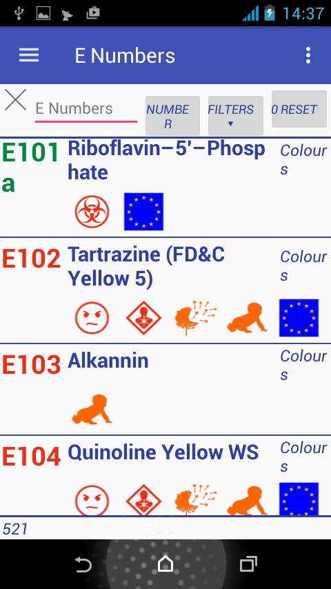
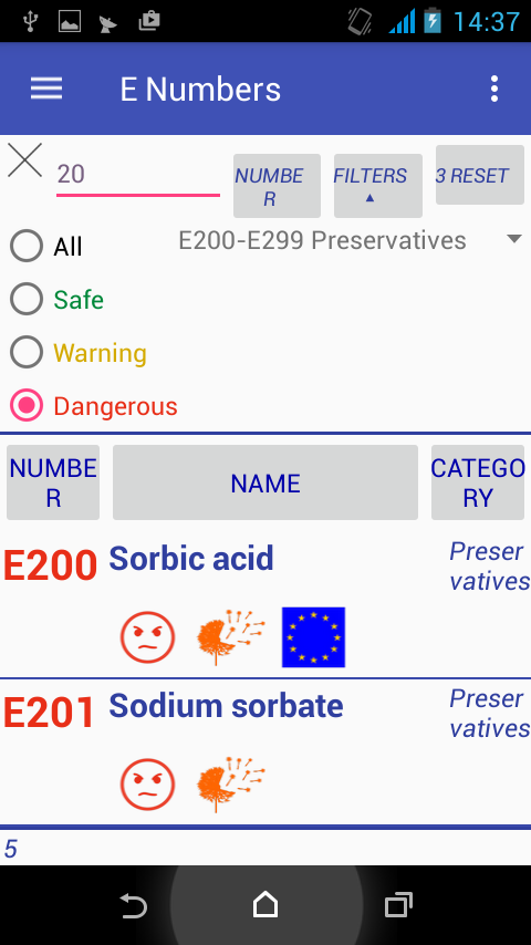
Description
App Information E Numbers
- App NameE Numbers
- Package Nameeu.uvdb.health.enumbers
- UpdatedMay 31, 2023
- File SizeUndefined
- Requires AndroidAndroid 6.0
- Version3.7.1
- DeveloperCygnus Software
- Installs10K+
- PriceFree
- Categoryinfo_outline</i></button></div>
- DeveloperJaworskiego8/15 25430Kielce Polska
- Google Play Link
E Numbers Version History
Select E Numbers Version :-
E Numbers 2.10.1 APK File
Publish Date: 2016 /4/13Requires Android: Android 4.0+ (Ice Cream Sandwich, API: 14)File Size: 5.3 MBTested on: Android 6.0 (Marshmallow, API: 23)File Sha1: 9cc908dd83ef9523b15facbb020be13fd75f025d -
E Numbers 2.9.1 APK File
Publish Date: 2016 /1/9Requires Android: Android 4.0+ (Ice Cream Sandwich, API: 14)File Size: 5.1 MBTested on: Android 6.0 (Marshmallow, API: 23)File Sha1: 28c3a3c249a9b936fa577afeb823e12a1954b83a
Cygnus Software Show More...


CPU Monitor PRO 1.19.2 APK
Find out what slows your Android device!CPU Monitor application provides information about all runningapplications on the device.Gets the CPU usage for each process. The data collected inreal-time configurable interval (1-10 seconds).In the PRO version, you can choose any applications to bemonitored.CPU usage is displayed on the notification bar and on thewidget.After exceeding a predetermined threshold level (10%), the color inthe list and on the widget changes from green through yellow, tored.Compared to competing applications, the CPU Monitor is muchbetterbecause it uses only about 1% of the CPU to work in monitoring modein the background, and about 4-10% while the standard.The PRO ads are disabled.Required qualifications:INTERNET, ACCESS_NETWORK_STATE - to display ads in the free versionand support my work (you can remove the ads in the "RemoveAds")CHECK_LICENSE - control of the pay-version licenseGET_TASKS, RECEIVE_BOOT_COMPLETED - to read data processor andautomatically start the application


World Map 2.9.2 APK
I present to you an application that includes an interactive map ofthe world. Each country has the data: surface area and population.For 120 additional flag is. The application is ideal for learningand fun. All countries are grouped by continent. They are presentedin a list with search engine. On the map, you can select the colorsin the two data any number of countries in order to compareselected groups of countries. Convenient and easy to use andnavigate user interface. Argentina, Bolivia, Brazil, Chile,Colombia, Ecuador, Paraguay, Peru, Uruguay, Venezuela, Canada,Costa Rica, Cuba, Dominican Republic, El Salvador, Guatemala,Haiti, Honduras, Jamaica, Mexico, Nicaragua, Panama, the UnitedStates, Algeria, Benin, Burkina Faso, Chad, Democratic Republic ofthe Congo, Egypt, Ghana, Guinea, Mali, Morocco, Niger, Nigeria,Senegal, Sudan, Tunisia, Ivory Coast, Angola, Cameroon, Ethiopia,Kenya, Madagascar, Malawi, Mozambique, South Africa, Rwanda,Tanzania, Uganda, Zambia, Zimbabwe, Austria, Belgium, Denmark,Finland, France, the Netherlands, Iceland, Ireland, Italy, Germany,Norway, Portugal, Spain, Switzerland, Sweden, United Kingdom,Albania, Belarus, Bosnia and Herzegovina, Bulgaria, Croatia, CzechRepublic, Estonia, Greece, Hungary, Latvia, Lithuania, Moldova,Poland, Romania, Russia, Serbia, Slovakia, Slovenia, Ukraine,Afghanistan, Armenia, Azerbaijan, India, Iran, Iraq, Israel,Kazakhstan, Pakistan, Saudi Arabia, Syria, Tajikistan, Turkey,United Arab Emirates, Uzbekistan, Bangladesh, Burma, Cambodia,China, Indonesia, Japan, Laos, Malaysia, Mongolia, Nepal, NorthKorea, the Philippines, South Korea, Sri Lanka, Thailand, Vietnam,Yemen, Australia, New Zealand, Papua New Guinea, Fiji The PRO adsare disabled. Be happy! Required qualifications: INTERNET,ACCESS_NETWORK_STATE - to display ads in the free version andsupport my work (you can remove the ads in the "Remove Ads")CHECK_LICENSE - control of the pay-version license

Similar Apps Show More...


TAHUNA 1.83.20243.27414 APK
Overview The free TAHUNA APP allows you to take advantage of allthetried and tested benefits of the TAHUNA outdoor navigationsoftwareon the move. Whether you are on holiday or at home – theTAHUNA APPoffers stress-free and reliable navigation and providesindividualnavigation profiles, detailed route planning and lotsmore extras toyour smartphone or tablet. The TAHUNA APP also makesit easier tolink to other mobile devices, allows you to analyzeyour data incomfort and installs updates automatically. Features -Optimized forBike Navigation and Outdoor Sport Activities - Onlineand OfflineMaps - Using tour-oriented OpenStreetMap database -Search Addressor POI - Route planning and Navigation - Createstunning Trips withrich POIs and share them easily - Unique Draw& Plan tool forthe most flexible route creation - Select anddownload trips fromthe hundreds of available ones which areprepared by professionals -Record and analyze your activityAvailable Modules for extending thecapabilities 1) Navigation -Voice navigation with clear visualindications - One of the mostsophisticated routing algorithm toensure the perfect ridingexperience 2) Fitness - You can set upyour own desired goals basedon distance, time, speed, calories -Sensor connection (heart rate,speed and cadence) 3) Gadgets - Eyecatching virtual dashboard -Compass, Speedometer, Altimeter andStaminameter 4) E-Bike -Connect your E-Bike via Bluetooth -Accurate range calculation anddisplay - Battery friendly routeplanning Fischer E-Bike owners canconnect their bikes via Bluetoothand get an E-Bike dashboard freeof charge. Please check thesupported E-Bike typeshttps://gpstuner.com/tahuna/supportedebikesSupport We arelooking forward to your feedback! Comments and questions tothe TAHUNA APP you can send here:www.tahuna.comwww.gpstuner.com/tahuna/[email protected]

wasserkarte.info - Löschwasser 1.16.8 APK
wasserkarte.info ermöglicht die Erfassung und Wartung allerrelevanter Daten von Hydranten und Wasserentnahmestellen. DiePlattform dient als zentrale, jederzeit aktuelle und mobileInformationsdrehscheibe für Gemeinde, Feuerwehr undWasserversorger. Mehr als 200.000 Hydranten sind bereits inÖsterreich, Deutschland, Italien und der Schweiz in der Plattformerfasst, die laufend aktualisiert und bearbeitet werden. Mitwasserkarte.info wird die Verwaltung von Hydranten undLöschwasserentnahmestellen, Dokumentationsaufgaben und Prüfungenoptimiert und effizienter gestaltet - und spart vor allem Zeit undKosten. Daten können einfach erfasst werden und der exakte Standortdurch GPS-Koordinaten oder durch die Verwendung einer Karte derfestgestellt werden. Löschwasserplanung einfach gemacht * EinfachVerwaltung, Bearbeitung und Neuanlage von Wasserentnahmestellen *Informationen wie z.B. Typ, Leistung und ein Foto derEntnahmestelle * Listen- und Kartenansicht aller Entnahmestellen *Sortierung(Filterung) nach diversen Kriterien möglich * Laden voneinzelnen Datenblätter mittels QR-Code * VerschiedenfarbigeKennzeichnung des Verwendbarkeitsstatus der EntnahmestelleVerbessertes Management von Löschwasserdaten * Einfache Erfassungund Aktualisierung der Daten von Wasserentnahmestellen *Übersichtliches und einheitliches Layout der Unterlagen undHydrantenpläne * Reduzierte Fehlerquote bei der Übertragung vonDaten von der schriftlichen Dokumentation in die HydrantenkarteNEU: Mit Augmented Reality Hydranten finden Informationen zumnächsten Hydranten werden mit der Augmented-Reality-Technologie amSmartphone-Display in Echtzeit eingeblendet. Diese zeigen wo dernächste Hydrant zu finden ist bzw. wie weit dieser entfernt ist.Damit kann das Auffinden von Wasserentnahmestellen, vor allem beider Lokalisierung von Unterflurhydranten im Winter bei hohenSchneelagen, sowie für Personen mit geringen speziellenOrtskenntnissen wesentlich erleichtert werden. Egal obUnterflurhydrant, Überflurhydrant, Löschwasserbehälter,Löschwasserteich oder Löschwasserbrunnen - mit wasserkarte.infosind alle Wasserentnahmestellen auf einer Plattform zusammengefasstund zugänglich. Bei Fragen oder Problemen zur App oder Plattform,schreiben Sie uns bitte direkt an [email protected] zu wasserkarte.info direkt unterhttps://nutze.wasserkarte.info


TOP tours: Bolzano & environs 1.9.13 APK
Whether in spring, summer, autumn or winter ...a holiday in Bolzanoand environs is good for body and soul and offers a broad varietyof hiking trails and destinations. Hiking and biking lovers willenjoy the comfortable temperatures in this cultural landscape,which is full of history. Top 7 destinations: – Geoparc Bletterbachand Monte Corno Nature Parc: The ‘Grand Canyon’ of South Tyrol wasformed about 15,000 years ago. It is nearly 8 km long and 400metres deep and is part of the Dolomites UNESCO World Heritage. –Lago di Caldaro/Kalterer See and Laghi di Monticolo/MontigglerSeen: During the summer, the popular bathing lakes of the UpperEtsch region are a great destination if you want to escape theheat. – South Tyrolean Wine Road: On more than 40 kilometres, theSouth Tyrolean Wine Road invites you to a tour of discovery throughthis blessed part of the world ... and its wines. – Saltenmountain: The sunny high plateau above Bolzano with its phenomenalpanoramic views and Europe’s largest larch meadows is an idealstarting point for hiking trips, cycling or horse riding. – ValSarentino Alps: 100 summits and peaks crown the Val Sarentino.Hikers, mountain bikers, friends of winter sports and ski tours, aswell as snow-shoe hikers can find a fascinating variety of holidayoffers in this valley. – Renon/Ritten: All year round, the Rittenmountain is accessible for hikers and during the winter, awell-marked hiking trail has turned into the first award-winningwinter premium hiking path in Italy. – Bolzano, capital ofSüdtirol/Alto Adige: There are three cable railways starting in theMediterranean wine town of Bolzano and reaching up into the highermountain regions (Colle/Kohlern, Renon/Ritten, SanGenesio/Jenesien). A first step into the Bolzano and environsregion is definitely worth taking. In any season! Attention: whenusing the app abroad you may incur in high roaming coasts. Yourbattery may run short when using the app in the background with anactivated GPS!


