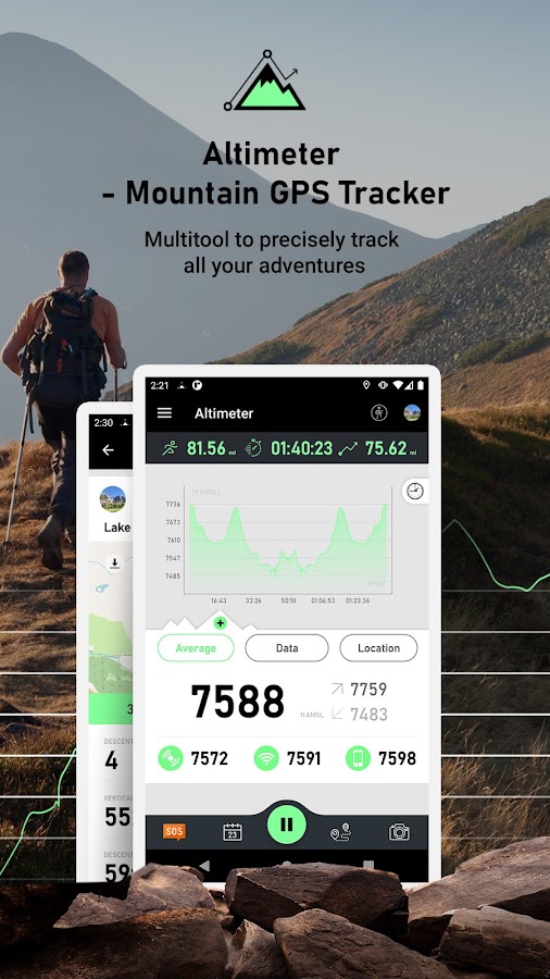


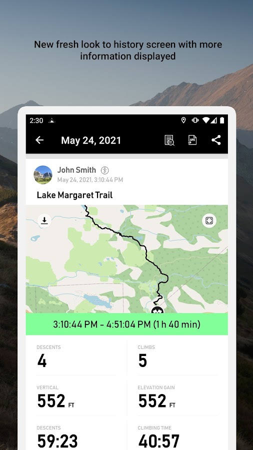


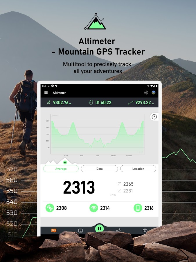
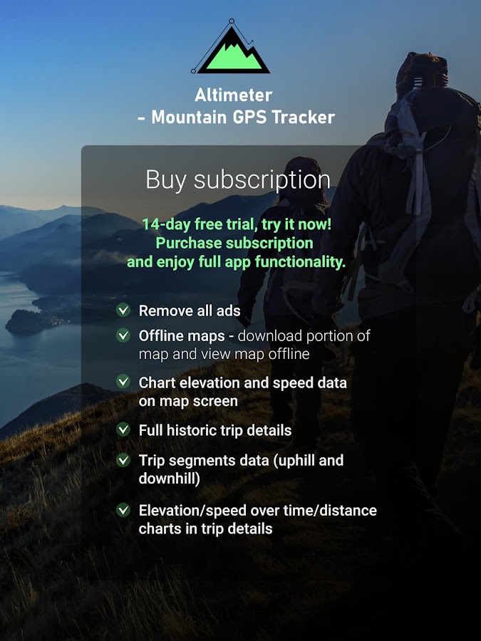


Description
App Information Altimeter Mountain GPS Tracker
- App NameAltimeter Mountain GPS Tracker
- Package Namecom.freemium.android.apps.tracker.altimeter
- UpdatedMay 15, 2023
- File SizeUndefined
- Requires AndroidAndroid
- Version4.0.5
- DeveloperMystic Mobile Apps GPS Tools
- Installs100K+
- PriceFree
- Categoryinfo_outline</i></button></div>
- Developer8 The Green, Suite B Dover,19901 Delaware, USA
- Google Play Link
Mystic Mobile Apps GPS Tools Show More...


Similar Apps Show More...


Altimeter Ler Live Gps Geotracker 2.6 APK
Modern Altimeter GPS+ app is for folks who care for hikingandbiking in mountainous terrain. GPS is getting very accurateinterms of distance indication. The choice between unit systemisperhaps an important thing, just for your convenience the appisbeing equipped with both of them (Imperial andMetric).Surprisingly strong barometer measures the weight of theairpressure above a given point and determines elevation oftwopoints. This app has a creative and user-friendlystyledesign, simple and comprehensive functionalities. Featuresincluded- Imperial and Metric unit settings. - GPS accuracyindicator. -GPS distance accuracy indicator. - Density of air ,indicator.Search any place and drop search pin with place info.Built inlibrary Map integration - GOOGLE maps - Satellite mapsmode. -Hybrid maps mode. - Standard maps mode. - Terrain maps mode.-Tracking location changes trajectory. Compass - Compass withcamera- Take a pictures with coordinates - Shows devicereal-timeorientation to magnetic fields. - Ability to switchbetween trueand magnetic North. - Location coordinates (longitude,latitude). -Course Track information - Time elapsed. - Distance. -Averagespeed. - Max speed. - Altitude. Tracking - Speed tracking inmph orkm/h based on MPH or KM/H mode. - Distance tracking in milesorkilometers based on MPH or KM/H mode. - Time tracking. -Longitude,latitude coordinates. - Save locations drop a pinWeather --Temperature information. -- Wind -- Visibility--Sunrise,Sunset -- High/Low Temperature. -- Abilitytoswitch between Celsius and Fahrenheit.


MyTrails 2.1.11 APK
No ads even in the free version! Perfect for hiking,riding,cycling, running, skiing or orienteering Premium topo mapsUsein-app purchases to subscribe to high-quality,special-purposemaps. Flexible offline mode and competitive pricing.• OS OpenData(GB) • IGN TOP25, TOP50, Cadastre, Satellite andLittoral (marinemaps) (FR) http://www.frogsparks.com/mytrails/ign/Full-screentrail map oriented with the built-in compass and GPSKnow exactlywhich direction you are going. Uncluttered map area,withunobtrusive controls and a traditional scale with trackdurationand distance. Hardware-accelerated map drawing allowssmooth andsnappy display even with tens of thousands of trackpoints. Stats40+ stats to choose from! Display them on a dedicatedscreen(including stats for multiple tracks at once), on theHUDoverlaying the map or even on Android Wear. Graphs Freelydefineaxes (over 30 combinations) to visualize your tracks,includingelevation profiles, speed vs. time, etc. Free online mapsPick frommany built-in online map sources (OpenStreetMap, Yahoo,Bing,Google and many other global and local providers). Add moremapsources using the configurable map sources (URL or WMS).Onlypremium maps are guaranteed: we may be forced to remove accesstoany of the free maps if requested by the rights-holders; thisisregardless of whether you are using the Pro or Freeversion.Offline maps Save battery and data charges. The mapdisplaysinstantaneously. No need to use desktop-based tools tocreateoffline maps, you can do it in MyTrails, in the background.RecordGPS tracks Visualize your track at any time and analyse yourcourseduring or after the outdoor activity. Display multiplecolorizedGPS tracks at once (Pro) Visualize your previous outingsand thoseuploaded to GPS community sites, so that you always pick agreattrail. Visualize the key indicators of the track (altitude,speed,rate of ascent, slope, GPS accuracy, etc.) right on the mapwith adetailed legend. Waypoints Manually add waypoints toindicatememorable spots or upcoming turns. Waypoints areautomaticallygenerated when getting directions or when you take abreak. Shareand archive tracks (Pro) Share your tracks on MyTrails, GPSies,UtagawaVTT and la-trace.com. Download tracks sharedby other usersin your vicinity. Gestures Easily switch betweenactive maps byswiping three fingers left to right in the map view.Pull down theHUD with information on your speed and altitude byswiping threefingers down your screen. Full tablet support Planyour outing on alarge-screen tablet, go out and have fun, and whenyou're back,view the track in full glory. Use Dropbox to seamlesslysynchronizebetween devices. FAQ: http://www.frogsparks.com/faq/Permissions:please see the FAQ


