


Description
App Information Zeeweer - Maritieme app
- App NameZeeweer - Maritieme app
- Package Namecom.surfcheck.zeeweer
- UpdatedMay 5, 2023
- File SizeUndefined
- Requires AndroidAndroid 4.4
- Version5.2
- DeveloperSurfcheck
- Installs10K+
- PriceFree
- Categoryinfo_outline</i></button></div>
- DeveloperMolenstraat 1a 2316 TC Leiden
- Google Play Link
Surfcheck Show More...

Weather in Holland: the app APK
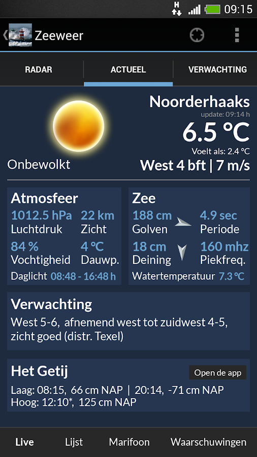
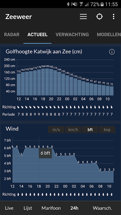
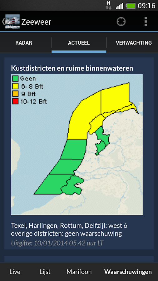
Stay up to date with the current weatherconditions in the Netherlands - and in the world via the Weatherstation widget. Reliable data live from the dutch national weatherservice KNMI.This app (Dutch name: Het Weer in Nederland) now contains 31 maps,forecasts and other items + 5 widgets and Android Wear Smartwatchapp!- Forecasts for today, this evening and tomorrow- Satellite images (visible light + infra red)- Detailed 5 day + text-forecast- Maps showing the current temperatures, wind speed (m/s and bft)and visibility- UV prediction for today and tomorrow- Precipitation map- Animated weather map (several days in advance)- Weather alarm + Coastal alarm- Three precipitation radarviews- Rotate your device to zoom in- Three app widgets bring live weather information to your homescreen, including weather station widget!Data is downloaded from the Dutch national meteorological instituteKNMI. Due to the nature of this source, some content (specificallythe text forecast) is written in Dutch.About KNMIThe Royal Netherlands Meteorological Institute (KNMI) is the Dutchnational weather service. Primary tasks of KNMI are weatherforecasting, and monitoring of weather, climate, air quality andseismic activity. KNMI is also the national research andinformation centre for meteorology, climate, air quality, andseismology.> widget only works when you run the app from phone memory, moveto SD card will disable it.Disclaimer:We do our utmost to deliver you the best software and dataavailable in the market, but of course we cannot guarantee theproper functioning or accuracy of both. Data sources can changeover time. You can not derive rights from this information. Bydownloading and using Het Weer in Nederland you accept theseterms.Location:The rough location permission is necessary to enable the Weatherstation widget to show you your local weather data. It is not usednor stored for anything else at all.


Similar Apps Show More...

KNRM Helpt 2.1.5.1 APK
Official app of the Royal Netherlands SeaRescue Institution (KNRM) - the ‘KNRM Helps’ app allows you toregister your vessel and plan and track your trip on yoursmartphone.Registering vessel and trip information could not be any easier.Follow the registration process to start using the app. Once yourregistration details have been saved, you can make your choice fromthe menu in the app. You may either plan and file your trip (Sailplan mode) or just activate the tracking function of the app (Trackonly mode).For filing a planned trip choose your vessel, determine the enddestination, calculate the ETA (Estimated Time of Arrival), enterthe number of persons on board and the activity type. Then, usingthe built-in maps, select a starting point, an optional waypointand the end destination. Once this is completed simply press the‘start’ button when you are ready to start your trip. You, youremergency contacts and eventually the SAR authorities will beautomatically alerted following a time scheme after the journeyexceeds the ETA in Sail Plan mode.Pressing ‘start’ in Sail plan mode or just pressing the startbutton in Track only mode will register the trip details withKNRM’s server and will activate position reporting in the app. Atregular intervals the app will send a position report to theserver.At any stage during the trip you can end your trip, revise the ETA,number of people on board or the destination.Use the KNRM Helps app to:- Improve maritime trip planning with Electronic Navigational Chart(ENC) data.- Quickly start recording using the ‘Track only’ mode to begintracking at a touch of a button. Change the recording interval tosave on battery consumption when your tracking is inprogress.- Find nearby port information, VHF channels, lifeboat station andbusy waterways information using the “Explorer” tool.- Access location-based, real-time weather & water data whenplanning your trip or when your trip is in progress.- Receive maritime safety messages and marine notices through theKNRM Helps app and SMS messages.- Check valuable maritime safety information when both online andoffline.- Create your own personalised checklist to be included as part ofyour Sail Plan before departing.- Activate a distress call or call for assistance while your tripis in progress. (iPhone only, not with iPAD)- Manage your profile, vessel, checklist and emergency contactinformation within the KNRM Helps app.Continued use of GPS running in the background can considerablydecrease battery life while in use.Please note:This application’s functionality and the information it containsare published on the understanding that end users are to applytheir own knowledge and skills in the use of saidapplication.Maritime safety is an extremely serious matter. In an emergencythis application’s function and information are not meant to berelied on exclusively. In addition, other reliable information andhelp from third parties should be looked for and made use of.This application can provide valuable coordinates of the user’sposition, as determined by the mobile device used and the GPSsystem. Mobile devices and their supporting telecommunicationnetworks are, however, not reliable and there is a real chance ofloss of connection between the mobile device and the mobile networkand / or the GPS system. Nor is there any guarantee that theconnection between your mobile device and mobile networks will beuninterrupted. The user hereby agrees to and accepts all risksinvolved in the use of this application.

Vaarkaart Friese Meren 2.11 APK
The perfect chart for sailing on the Frisianlakes. This chart is made for boat renters, skippers and crew ofsail boats, motor boats and barges. Also recommended for canoes andfishers.AreaFrom Stavoren to Grouw, with the following lakes:: Heegermeer,Fluessen, Morra, Oudegaster Brekken, Zwarte and Witte Brekken,Sneekermeer, Koevorden, Tjeukermeer, Langweerderwielen, andPikmeer/Wijde Ee.This is a detailed chart with a scale 1,3m/pixel. This comesdown to about 1 : 5000 on the screen.Depth viewWith clear depth view from the Friese Meren Project in well coloreddepth areas on the lakes and depth numbers along the water ways.Developed by Stentec in cooperation with the province Fryslân basedon the most recent depth measurements.WaypointsThe included database contains 2345 waypoints divided in 13 groups.The 145 marinas show phone numbers and websites. Other groups areamong others bouyage, mooring spots, campings and gas stations.The accurate positioned bouyage contains the so called‘slobbers’. These mark the protected bird area from 1 October to 1May. Outside this period these are replaced by yellow regattabuoys.Marrekrite 2014 natural mooring places are also included in thechart. You can easily see if camping is allowed (CAMP), if acontainer is present (CONT) or if you can moor (WAL).The bridges and locks along the water ways are shown with heightand width so you can easily plan your route. The many aquaducts arealso shown. Most bridges are operated daily from 1 May to 1November from 9h-19h. In June, July and August even until 20h.


SailDroid APK
The Sailing AppApp for sailors, yachts and boats, containinga set of nautical applications:- Magnetic Compass- Speedometer in knots, mph or km/h, Course over Ground- Position- Mark or edit waypoints- Import Waypoints from gpx file- Distance measurement in nautical miles and meters. Also usefulfor anchoring.- Course to WaypointAll in large, high contrast characters


