


Description
App Information Variometer-Sky Land Tracker
- App NameVariometer-Sky Land Tracker
- Package Namecom.jonathanVARIOMETER
- UpdatedJune 23, 2017
- File SizeUndefined
- Requires AndroidAndroid 4.0.3 and up
- Version16.8
- Developerseungho.woo
- Installs1,000 - 5,000
- Price$8.99
- CategorySports
- DeveloperVisit website Email [email protected] Privacy PolicyAango-Ro 339 Jinhae-Gu CangWon City KyungNam South Korea
- Google Play Link
seungho.woo Show More...

Variometer-Sky Land Tracker 16.8 APK
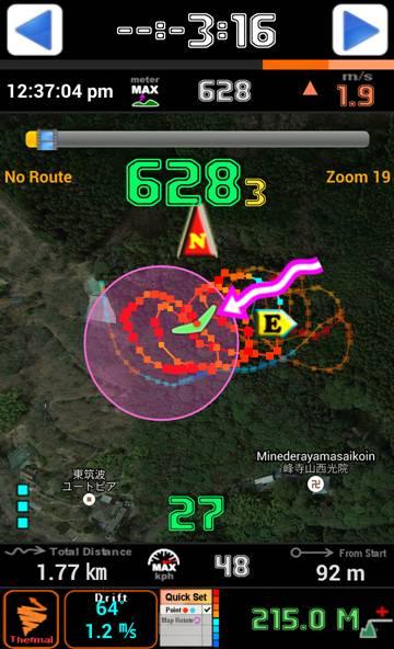
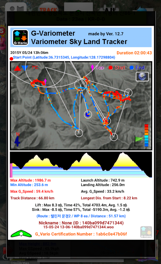
Variometer, Vario, G_Vario, G_Variometer,Tracker (Compatible for GPS only or Phone Baro Sensor or FlyNet2 orBlueFlyVario or GoFly Pico), 3D Track View with 3D terrainmaps.Paragliding, hang gliding and all air sports, Radio Control Planeand skiing, sailing, mountain climbing, etc.Portal tracker instruments for all Outdoor sports.Support MOBAC offline map & Self Downloading OSM & SupportMapsForge(.map) offline mapSupport FAI-CIVL(http://vali.fai-civl.org/supported.html) valid IGCfiles. (GNSS : http://g-variometer-vali.blogspot.kr)Flight instruments is expensive, but your phone is also expensiveequipment.Your phone is better than that , you can perform a variety offunctions.Using Compass & GPS & Pressure Sensor, flight time, speed,altitude, vertical speed, L/D is displayed.If your phone is equipped with pressure sensor, In air sports mode,variometer functions can be maximized.Pressure Sensor sensitivity of this filter using the FourierTransform is better than any other filter using a simple lowpassfilter or kalman.Therefore more precise user setting is possible.After simple one click, Ready to take off at once, auto-start-stop,manual-start-stop is possibleBig font and high contrast raised the visibility in outdoor.Through manual built in the app, you can learn easily how touse.Flight time, battery level, GPS status, and vertical speed, maximumspeed, speed, maximum altitude, altitude, Hpa pressure, temperature(varies by altitude), weather (wind direction, wind speed), Taskorientation, remaining distance, the total path length, FuelGage(for Motor Skysports) are displayedIt displays the direction and intensity of drift and thermaldetecting also.Waypoint and Route creation is easier and faster than any otherapp.Waypoint Import Export Support (WPT, CUP format)Map of the Google, OSM, mapquest, Naver, GoogleV2 is in use.Track play function is best function same as seeing the actualflight.Indexing and rewinding and the execution speed can beadjusted.You can also see in 3D Track(shared track) with 3D terrainmaps(shared track).Seeing track thumbnail, you can easily find a specific flightrecord andYour indexing speed can be also fast through altitude graph.Track files can be sent via email to other users andIn addition, KML, GPX files are saved and automaticallyconverted.Navigation displays to the users the real-time shortest course fromthe current location and flight direction to next task, remainingdistance, needed altitude against glide ratioIn briefing, share discussion with colleagues easy.The units (mile, feet, meter, knot, ft / s, m / s, mph, kph, ℃, ℉)can be freely selected.Coordinate system of the DD-MM-SS.SS, UTM, WGS84, etc can beselectedWhen performing in background Mode, track can be recordedthroughout the day precisely andDuring the mode, the sonic variometer functions and task passing,starting height sound alarm can be performed continuously.The altitude can be set in a variety of ways.Based Terrain Elevation, sea level air pressure reference, GPSaltitude, the user manual setting is possible.GPS environment will be best in flight, You can get reliableperformance.For feature requests and uncomfortable, please send mail [email protected]

TOEIC Timer 3.8 APK
TOEIC Time scheduler ! Very Simple CountDownTimer!TOEIC Final CountDown !We don’t have enough time on TOEIC Reading Part 5,6,7.1.This application check time for each problem of part5,6,7.2.You can reschedule your time as you please.3.You can select sound & vibration mode.4.You can select parts as you please.Version 2.01. Design Upgrad2. Add 3-2-1 3 seconds count(Marking Time Alarm)Version 3.01. Back, Home buttons -- BugFixVersion 3.01. To insert time graph
Similar Apps Show More...

Variometer-Plus 2.5.15 APK
Its a must have app for paraglider, hangglider, outdoor walkers, sailor ... .Using speech instructions you can enjoy your course and listensimply to direction informations (like known from car navigationdevices) or your climb/decline rate using beep tones just like areal variometer or view your track in real time. AdditionallyGoogle Earth is now supported (KML-File), to send (via email) andview your tracks offline on your home PC... .The latest version supports (2.5.5) also the hydrostatic sensor(barometer), so the climb rate will be calculated based on ‘true’air pressure like real variometer’s do.This option will be additionally available, if your mobilephone contain this particular sensor, otherwise Gps-based or phoneacceleration sensor based calculation take place.Feel free and enjoy your lifestyle.Please read the short usage hints under:http://wrapware.de/android/variometer.htmlVersion highlights:===================2.5.11- Several Fixes2.5.10- Fixes for Samsung Galaxy S3- Barometer manuell correction added (first option in menu'more')2.5.6 - 2.5.9- Add sea level calibration for barometer- Barometer finetuning, more sensors, UI revised2.5.5- Add the hydrostatic sensor (barometer) to calculate the verticalspeed (climb rate) based on ‘true’ air pressure- Fix UI problems on larger screens2.5.4- Revise and polish complete UI- Add realtime view of track position in online-mode- Add route and track management- Track view offline in the app- Add Google Earth support to view tracks and several sensorinformations offline on your PC- Add send Tracks (KML-File) via Email


VarIO Variometer 1.5 APK
THIS IS NOT A "GPS VARIOMETER" but THE REAL THING! TEST MODE worksfor Gingerbread Honeycomb and Ice Cream Sandwich This app worksONLY with an EXTERNAL USB barometric pressure sensor and does NOTwork with the internal barometric pressure sensor. From the menuyou can use the 'Test Mode' and adjust the sink/lift frequenciesand thresholds, QNH reading from a location near you and units ofmeasurement imperial/metric. Once in Test Mode, a SeekBar will bedisplayed to allow you to test your changes. If your Androidversion is Ice Cream Sandwich AND your phone supports USB HostMode, You have a USB On The Go cable and an adapter to the sensorUSB mini connector (pictures available on our website) continuereading: You then purchase the External (USB) Barometric PressureSensor available at our website this application BECOMES ALIVE. Thepressure read from the external sensor is then converted toaltitude based on QNH and the vertical speed is displayed togetherwith the temperature. Accuracy is 0.1 millibar which translates to70 cm or 27.5 inches. This is accurate enough to use it as anadditional indicator in the pocket of your hangglider or paragliderharness or take it with you in your sailplane or ultralight. Do NOTUSE this device as your main Altimeter/Variometer! Its accuracy isNOT good enough to use it as a flight instrument. This is not aflying instrument but just a gadget that ... works. If you're notflying you can still use it as an altimeter a thermometer or abarometer or all those put together in an application - on yourphone. Have fun and ... Happy Landings!


CompeoVario Map Variometer 14 APK
CompeoVario is a glide computer for glider pilots, paragliders andhanggliders. All needed files will be created on CompeoVario folderon phone sdcard. Deafult.tsk (compatiple with xc soar) Deafult.cup(SeeYou Waypoint format is a simple comma separated text file. Itsextension is .CUP) Thermics.txt ( Thermic points are stored ascomma separated text Name;Lat;Lon;Altitude in meters , sample:T0;39.933667;32.279417;654.0) From menu -> Manage Files: Youmay: 1) open an existing task (.tsk) file. (will be drawn on mapautomatically) 2) open waypoint (.cup) file. (will be drawn on mapautomatically) 3) create thermic points from existing flight log(igc format) (will be drawn on map if you select draw thermicpoints from settings) 4) delete any file. From menu -> Task: Youmay: 1) open an existing task (.tsk) file. (will be drawn on mapautomatically) 2) change position of turnpoint by moving point. Forthis touch on move icon at left side (long touch on icon) 3) changevalues of turnpoint by clicking item. 4) delete task file. Frommenu -> Settings -> Map tile provider: You may select one ofbelow map as a tile. Mapnik (cache available) Cycle (cacheavailable) Landscape (cache available) OutDoors (cache available)And plus: Google Map Types. (cache not available) For maps :http://www.thunderforest.com/maps/ The Software also has anbarometric sensor variometer. For mute on-off just touch on variotext. Live logging Livetrack24 supported. Please enter yourusername and password from settings. And local logging is alwaysactive, files will be stored in CompeoVario folder as igc file. Thesoftware is still on development. The feedbacks from you, will beeffective for me on this process. [email protected] This isfree open source software, developed by Türkay Biliyor.https://github.com/takyonxxx/CompeoVario Turkish: CompeoVario,yamaç paraşütü pilotları, planör ve hangglider'lar için bir uçuşbilgisayarıdır. Gerekli tüm dosyalar telefonun sdcard'ındakiCompeoVario klasöründe oluşturulacaktır. Deafult.tsk (xc soar ileuyumlu) Deafult.cup (SeeYou waypoint biçimi basit bir virgülleayrılmış metin dosyasıdır, uzantısı .CUP'dur) Thermics.txt (Termiknoktalar noktalı virgülle ayrılmış metin olarak saklanır Adı;Enlem; Boylam; Yükseklik, örnek: T0; 39.933667; 32.279417; 654.0)Menüden -> Dosyaları Yönet: Şunları Yapabilirsin: 1) mevcut birgörev (.tsk) dosyasını açın. (Harita üzerinde otomatik olarakçizilecektir) XC soar task dosyalarını direkt açabilirsiniz. 2)mevcut waypoint (.cup) dosyasını açın. (Harita üzerinde otomatikolarak noktalar gösterilir) 3) mevcut uçuş kaydından (igcformatında) termik noktalarını oluşturun. Bu noktalar anlıkuçuşunuzda da termik bulunduğunda otomatik kaydedilir. (Ayarlardantermik noktaları çizmeyi seçerseniz harita üzerinde çizilecektir)4) herhangi bir dosyayı silin. Menüden -> Görev: ŞunlarıYapabilirsin: 1) mevcut bir görev (.tsk) dosyasını açın. (Haritaüzerinde otomatik olarak çizilecektir) 2) Dönüş noktasınıistediğiniz pozisyona kaydırabilirsiniz. Sol taraftaki kaydırmahareket simgesime uzun dokunun ve kaydırın. 3) öğeyi tıklayarakdönüş noktasının değerlerini değiştirin. 4) görev dosyasını sil.Menüden -> Ayarlar -> Harita tipi değiştirici Haritalar için:http://www.thunderforest.com/maps/ Yazılımın barometrik sensörvaryometresi de vardır. Sesi açma-kapama için sadece vario metnedokunun. Livetrack 24 desteklenir. Lütfen ayarlarınızdan kullanıcıadınızı ve şifrenizi girin. Ve yerel kayıt her zaman etkindir,dosyalar igc dosyası olarak CompeoVario klasöründe saklanır. Banahertürlü fikriniz için email [email protected] Türkay Biliyor tarafından geliştirilenücretsiz açık kaynaklı bir yazılımdır.Https://github.com/takyonxxx/CompeoVario

Vario Variometer 1.1.111 APK
--- THIS PRODUCT IS NOW DISCONTINUED ---Want an alti-vario like a Brauniger or Flytec but don't want thepremium price tag? The Flight Bandit Vario is for you. Connect yourphone to a Flight Bandit Flight Pod (sold separately) and turn itinto a fully featured, pressure based, alti-variometer with flightrecorder.The Vario features• All your essential flight data - Altitude, lift, liftaverage etc.• High accuracy flight data - Detects altitude changes assmall as 10cm• Custom screen layouts - Make sure you only seeing what'simportant to you• Custom screen colours - High contrast options for seeingthe screen in bright sunlight• Configurable acoustic threshold - When to start yourlift/sink audio• Configurable acoustic themes - Bored of hearing your variobeep? This is for you• Configurable filter levels - Customize the variometer todetect every change in altitude or smooth out the smallerchanges• Configurable lift averager period - Change the time yourlist average is calculated over• Selectable altitude and lift units - Metric or Imperialfor everything• much much more...The Vario flight recorder will capture your flight data 4 timesa second. Once you land you can check out your flight highlightsand export your flight in Excel format to share with everyone. On a64GB micro SD card you can record up to 7 years of flight data, ifyou ever need it, sweet!If you're travelling light, or forget your phone, the Flight Podalso doubles up as an acoustic vario. When connected to the Varioapp the Flight Pod will run for 12 hours on a single charge. Usingthe Flight Pod as a standalone acoustic vario increases this toover 50 hours. If you do find the battery running out, it rechargesin only 90 minutes using the same micro USB charger as your phone.Want to use the Flight Pod with XCSoar? Yep, it can do thattoo.This app is fully featured for 5 minutes. After that time theapp can still be used to customise the acoustic thresholds, filterlevels, lift average and acoustic theme of your Flight Pod, butflight display and recording functions will be disabled. To upgradethis app to display and record unlimited flight data you will needto purchase an upgrade license. Check out our website (http://www.flightbandit.com) for moredetails.Don't have a Flight Pod? You can use this app to check how thescreen layout and colours will look on your phone or tablet beforebuying.To find out more details about the Flight Bandit Vario check outour website at www.flightbandit.com or visit our YouTube channel athttp://www.youtube.com/channel/UCqsUSGvZMJZoNrqyRzLcMeQKeywords: altivario, bluetooth, paragliding, hang gliding,ballooning, paraglider, parapente, pg, hg, alti, altitude, thermal,lift, sink
Sports Top Show More...

FIFA 15 Ultimate Team 1.7.0 APK
FIFA 15 Ultimate Team by EA SPORTS featuresover 10,000 players from over 500 licensed teams. Plus, over 30real leagues and stadiums! Build a dream squad of footballers andput them to the test. From the English Premier League, La Liga, andMLS, to the German Bundesliga and beyond. Take the thrills with youwherever you are with the most authentic soccer game on GooglePlay.This app offers in-app purchases. You may disable in-apppurchasing using your device settings.** This game has superior graphics and is packed with tons ofreal football leagues, teams, and players. Please make sure youhave at least 1.35GB of free space on your device. **BUILD YOUR ULTIMATE TEAMEarn, trade, and collect superstars like Lionel Messi and EdenHazard to create your own fantasy team. Choose your play style,formation, kits, and more.PLAY IN QUICK SIMULATION MODEPut your management skills to the test with new Quick Simulations.Set up your squad, start the match, and watch it unfold. Make smartsubs, tactical tweaks, and gauge team effort along the way. Yourmatch results depend entirely on your ability to manage playerskills and chemistry – taking authenticity to the next level.OR TAKE IT TO THE PITCH!If you’re new to FIFA on mobile, try out our “Casual Controls”,with elegantly simple buttons like “shoot”, “pass”, or “sprint”.Once you’re feeling comfortable, move on to “Classic Controls”,which let you add either “through passes” or “skill moves” to yourgaming arsenal. Or, you can interact with your team directly,tapping on players to pass the ball and swiping towards the net toshoot. Plus, if you have an external controller – don’t miss thechance to use it on the pitch for the first timeREAL WORLD MATCH UPSPlay your favorite team’s next fixture, plus 3 other majormatch-ups happening around the world – every week!Jump into the action and feel the passion of your favorite sportwith FIFA 15 Ultimate Team!NOTES:Terms of Service: http://www.ea.com/terms-of-servicePrivacy & Cookie Policy: http://www.ea.com/privacy-policyGame EULA: http://tos.ea.com/legalapp/mobileeula/US/en/OTHER/Visit https://help.ea.com/ for assistance orinquiries.EA may retire online features and services after 30 days’ noticeposted on www.ea.com/1/service-updatesImportant Consumer Information: This app: Requires acceptance ofEA’s Privacy & Cookie Policy, TOS and EULA; Includes in-gameadvertising; Collects data through third party ad serving andanalytics technology (See Privacy & Cookie Policy for details);Contains direct links to the internet and social networking sitesintended for an audience over 13.

Real Football 2012 1.6.1d APK
Real Football is back for the new season,bringing football on mobile to a new era! Join the community offans as you create and share content with the Custom Kit Editor.Experience the ultimate football game on smartphone thanks to manymajor improvements and the addition of the most complete andenjoyable community-oriented features.Love football. Share football. Join the community.REPLAY THE GAME YOU JUST WATCHED ON TVEver wish you could control the outcome of a game you watched onTV? Now you can, thanks to Hypergame technology! With just thepress of a button, you can recreate any match-up from the in-gamenews feed and play!STAND OUT ON THE FIELD WITH CUSTOM KITSCreate your own custom team jerseys, shorts and more using adetailed editor, then share it with the rest of the community, orlook for cool designs made by other players and use themyourself.THE BIGGEST, MOST ENJOYABLE FOOTBALL COMMUNITYGet the latest football news thanks to official RSS feeds fromgoal.com, as.com and sports.fr. Send your comments, interact withfriends, upload pictures and videos.FOOTBALL AT ITS FINESTEnjoy smoother and more realistic graphics for both players andstadiums.Over 700 motion-capture-based animations that adjust to players’skills and positions on the field.Smarter moves for your teammates and opponents on the field thanksto an improved AI.New effects and cutscenes during the games for an even more TV-likefootball experience.THE OFFICIAL FIFPRO LICENCEThousands of real players’ names, 350 teams and 14 leaguechampionships to play including England, Spain, France, Germany andSouth America.Online updates of the database will keep your game up to date withthe most recent player transfers and lineup changes.MANY GAME MODES TO ENJOYAccess many different game modes including Exhibition, League andvarious International Cup modes, or practise your skills inTraining mode.You can also take over your favourite team as a manager and lead itto glory, or replay the best games of the past by entering Historymode.Certain apps allow you to purchase virtual items within the appand may contain third party advertisements that may redirect you toa third party site.Privacy Policy : http://www.gameloft.com/privacy-notice/Terms of Use : http://www.gameloft.com/conditions/End User License Agreement : http://www.gameloft.com/eula/

Real Football 2013 1.6.8b APK
The newest edition of the free footballsimulation is back to score another win for the franchise with awhole new set of moves.Take part in the most immersive free football simulation and showthat you are the best on the pitch. Reinforce your team ofchampions by developing your club’s facilities, hiring new staffmembers, dealing with sponsors and more.Join world football champions like our cover athlete, Falcao, onthe pitch. YOU ARE FOOTBALL, YOU ARE REAL FOOTBALL!LEAD YOUR CLUB TO THE TOPTake control of your team on the field during league games or cupgames. Starting with a rookie team, you’ll need to improve yourplayers’ abilities to reach the top league and compete against thebest teams in the world for the championship and the cup.REALISM PUSHED FURTHERFor the first time in Real Football games, see names and portraitsof over 3,000 top Euro and international champions thanks to theofficial FIFPro licence. Updates for the application will keep yourgame up to date with the most recent player transfers and rosterchanges.DEVELOP YOUR CLUBThe best teams in the world have the most modern facilities. It'stime to be a good fantasy manager. Get your players in shape bydeveloping your training grounds to increase your players’physical, technical and tactical skills as a real manager. Earnmore money and attract fans by expanding your stadium, filling itwith shops and signing big-name sponsors.THE MOST IMMERSIVE EXPERIENCESmooth and realistic graphics make every player come to life onyour screen during games. Witness over 700 motion-captureanimations as you take on an improved AI for a TV-like experienceof games with spectacular effects and cutscenes. It's just likewatching real sports!RF13 is a free simulation sport game in which you'll be able towin a league or cup championship, play with world champions, be amanager of a fantasy team, and more. We're bringing you a real,free fantasy simulation and a comprehensive manager game, all inone soccer package.Whether you like soccer simulations, fantasy manager games oryou're simply a fan of the sport, this free game is for you.----Visit our official site at http://www.gameloft.comFollow us on Twitter at http://glft.co/GameloftonTwitter or like us onFacebook at http://facebook.com/Gameloft to get more infoabout all our upcoming titles.Check out our videos and game trailers on http://www.youtube.com/GameloftDiscover our blog at http://glft.co/Gameloft_Official_Blog for theinside scoop on everything Gameloft.Certain apps allow you to purchase virtual items within the appand may contain third party advertisements that may redirect you toa third party site.Privacy Policy : http://www.gameloft.com/privacy-notice/Terms of Use : http://www.gameloft.com/conditions/End User License Agreement : http://www.gameloft.com/eula/

PES CLUB MANAGER APK
The "PES" soccer simulation game has beenplayed by more than 23 million users around the globe.After a major update, the game's cover now features the prestigiousGerman club, BORUSSIA DORTMUND. In addition, the renewal of theentire training mode allows you to enjoy an in-depth playertraining experience.Official players and teams have also been updated to the latest2016/17 winter season.Match commentary is available in 9 different languages (English,Japanese, Mandarin Chinese, Cantonese, etc.) so you can enjoy thistop-quality free-to-play soccer simulation game anytime,anywhere.Test your management skills as the team's manager, owner, andscout. Challenge rival managers around the globe in every aspect ofsoccer![PES Console Game Engine on Mobile Devices]Enjoy playing realistic soccer matches with high-quality 3Dgraphics and analyzing tactics in realtime on an animated 2Dscreen.[Licenses Around the Globe]Official licenses for popular European and Southern Americanteams/leagues are included, with more than 5,000 authenticplayers.[Soccer Simulation Enjoyable for Core Strategists (Basic GameplayAll Free)]Simple controls allow you to easily set tactics during matches. Thetide of matches will change based on your management skill.Experience gripping matches in which you are in totalcontrol.[Try out your Soccer Theory in Player Training Mode]Train players however you want by assigning them to a qualitytrainer and the training venue of your choice. You can competeagainst rivals around the world with the team built under your teamconcept.[User-Driven League]No need to log in at a fixed time. Play each season at your ownpace.[Play the Global Standard of Soccer Games for Free]Winning matches with your own tactics/skills is more satisfying.Win League/Cup rewards to build your team. Bid for players on themarket at the lowest price.We recommend PES CLUB MANAGER if you:・For those who want to construct a great stadium that will beiconic to the club's fans, just like how Borussia Dortmunddid.・Possess a soccer philosophy like FC BARCELONA.・For those who are attracted to clubs like Borussia Dortmund, ateam that contributes to their hometown and is loved by their localfans.・Believe tradition is important for a soccer club.・For those who want to improve their soccer tactics by makingflexible tactical changes during matches like Borussia Dortmund'smanager, Tuchel.・Think a soccer club can become something more than a "club".・Believe "winning in a style" is the ideal victory.・Think soccer is all about tactics.・Want to manage a dream team with your favorite players.・Want to become an owner of a soccer club with a longhistory.・Want to test out new soccer tactics.・Are curious about young soccer stars.・Are curious about mid-season transfers.・Watch national matches.・Root for young players in international tournaments.・Think training young generations is important.・Think philosophy is necessary for strong clubs.・Soccer is your favorite sport.* PES CLUB MANAGER is a free-to-play app. No purchases arerequired. All users can play the entire game free of charge,although purchasing PES Coins can speed up gameplay and help tostrengthen your club faster. In-app purchases can be disabled by“limiting in-app billing” on the device used.Required OS: Android 4.2.0 or later*Operation is not guaranteed on other OSes.Compatible devices:http://www.konami.jp/pescm/jp/sp/info/compatible_model.php5*Please note that support is not offered in response to inquiriesthat involve non-compatible devices.This is an online game only. Users must be connected to theinternet (3G,4G,or Wi-Fi) to play. Internet connection charges maybe incurred separately depending on the user's networkenvironment.Use of this app requires agreement to the app’s Terms of Use,Virtual Currency Terms of Use, and Privacy Policy.License Rights:http://www.konami.jp/pescm/en/sp/info/licenses.php5

Top Eleven 2017 - Be a Soccer Manager 10.9.2 APK
Join over 150 million players worldwide tobecome the best soccer manager with the unbeatable excitement ofTop Eleven! Run your own soccer team - apply Mourinho’s besttactics, use his brilliant line-up or create your own strategies tobeat the competition.Play Top Eleven and experience all the excitement of managing areal soccer clubTop Eleven is the most-played online soccer manager game - Createyour own world-famous soccer team. Test and improve your skillswhile playing against other managers from around the globe. Formyour soccer team in the spirit of the best clubs. Choose officialjerseys and emblems of the best soccer clubs from the PremierLeague, Bundesliga, MLS, the legendary Champions League and manymore soccer leagues.Begin your journey to become a soccer manager today!Join forces with friends, talk tactics, compare with other soccerteams and beat the competition in this one-of-a-kind freemultiplayer game! Organize the best training sessions, level-up andwin bonuses to encourage your team's progress. Pick your topplayers to create the best team possible. Motivate your players onand off the pitch and start scoring goals! Top Eleven brings youthe most socially engaging soccer manager experience as youchallenge real people worldwide or collaborate with them using ournew associations social feature!★Bid for players as you follow the live soccer transfermarket★Build your own winning strategies★Follow your team’s performance in live matches★Develop a stadium with all surrounding facilities★Challenge other soccer managers in competition andfriendlies★Win Cups and qualify to play in the Champions League★Create your very own soccer association and invite friends tojoin in as you compete against others!Top Eleven is translated into 30 different languages!---For any issues or suggestions regarding the game, simply contact usat https://nordeus.helpshift.comOur Player Support team offers support in 10 languages.

ICC Pro Cricket 2015 2.0.23 APK
ICC Pro Cricket 2015Play the Official Game of the ICC Cricket World Cup 2015.This game features over 150 official players from the 14 teams ofthe ICC Cricket World Cup 2015.****Nominated by the FICCI BAF AWARDS 2016****_________________________________________________________"The game is optimized for Quad core ARM 7 Devices with 2GB of RAM,Android 4.2 and above. There might be visual and functionaldiscrepancies on lower devices."Support id: [email protected] with us on: https://www.facebook.com/ProCricket2015__________________________________________________________Do you want a taste of Real Cricket?One of the most detailed and realistic cricket simulationexperiences of its kind, “ICC Pro Cricket 2015” is a gamers delight– equipped with 2 game play cameras and over 25 in-game cameraangles, the cricket fever never stops.Bored of playing the usual fantasy league, county cricket and testmatch games?Don’t stick to the old cricketing format; move on to the T20 styleof big shots and big plays.Taking inspiration from ICC Champions Trophy 2016 we have a new andimproved game for our fans.ICC Pro Cricket 2015 is a real Cricket 3d simulation game where youcan get the excitement of an ODI match on your mobile screen.Play different modes, get your favorite players and make sure youbeat your opponent to ashesBuild your dream team with players like Chris Gayle, Virat Kohli,Steve Smith, AB de Villiers and Rohit Sharma to name a few.You might be a WWE or a Fifa fan, you might even love Basketball,but this will surely make you feel like you’re playing the WorldCricket Championship.Features:• First ever cricket game with real simulation and cardmanagement.• Modes: ICC Cricket World Cup Tournament, World Tour Mode (Dreamteam) and Quick Match Mode• All 14 participating ICC Cricket World Cup 2015 Countries withthe original Player names.• Motion captured animation to get the real cricketingexperience.• Intuitive batting Controls & Innovative Bowling controls.Control the speed, line and length.• Complete your daily objectives to earn gold which will help youstrengthen your squad.IMPORTANT CONSUMER INFORMATION:ICC Pro Cricket 2015 respects your privacy and does not store anypersonal informationWe do require a few additional Permissions to make your gamingexperience better:• We need access to photos media and files to install thegame• Contacts to access Google play• Phone for game pause on receiving calls• Location for relevant advertisement servingPRIVACY POLICY:To read our complete privacy policy please visit the below URLhttp://www.disney.in/privacy-policy.htmlhttp://www.disney.in/addendum-to-global-privacy-policyICC Pro Cricket 2015 and Indiagames Cricket Card Battle areproduced by Indiagames Ltd., an affiliate of the Walt DisneyCompany.About Disney India’s Interactive Business:Disney India’s Interactive business is a hub for creation anddistribution of high-quality digital content reaching out tomillions of users in India. It develops and delivers multi-platformgames and digital products including apps for multi-brands underDisney India - Indiagames, UTV, Disney, Marvel, and Disney.Pixarand distributes the content via mobile operators and various OEMapp stores in India and globally.Copyrights:The ICC symbol, name style, typeface, colors and logo and those ofthe ICC Cricket World Cup 2015 (any or all of which are referred toas the “ICC Identity”) are trade marks and (as appropriate)copyright works of ICC Development (International) Limited (“IDI”)© 2001-2015. All rights in the ICC Identity remain the property ofand are reserved to IDI. All proprietary names, logos and marksrelating to the ICC Identity, the ICC Cricket World Cup 2015 andthe participating teams that appear in this game remain theproperty of their respective owners and are used herein underlicense.

Dream League Soccer 2.07 APK
Top 10 Sports Game in Italy, Singapore,Belgium & Turkey!Soccer as we know it has changed! Dream League Soccer is YOURchance to build THE best team on the planet. Recruit new Players,upgrade your Stadium, and train your team as you march towardsglory, on your road to Soccer Super Stardom!Download Dream League Soccer for FREE now!* Includes Tablet Support! ******************************************BUILD YOUR TEAMUse our in depth transfer system to build the team of your choice!Sign players using coins or even spot a bargain in the freetransfer market! Develop a team of up to 32 players for theultimate experience, including the ability the create your ownplayers!INTELLIGENT AI, RAPID GAMEPLAY & SHARP VISUALSSmart defensive and attacking player AI form a challenging andaddictive experience. With intuitive controls & excellentvisuals, Dream League Soccer is the perfect Soccer package whichcaptures the true essence of your favourite sport.COMPETE ACROSS 4 LEAGUES IN A BID TO RISE TO THE TOP!Got the skills to gain promotion into the Elite Division? Or ifthat’s not enough, it doesn’t just end there...Friendly matches,the Global Challenge cup and a few extra prestigious competitionsawait the very best Dream Teams out there!DEVELOP YOUR PLAYERS TO REACH THEIR FULL POTENTIALTrain your squad members in our unique player development program.Increase Ball Skills, Fitness, Distribution and much more!MEET YOUR TARGETSStrive every match to achieve your board’s season and matchobjectives, also keep your fans happy with our very own fan ratingsystem!GET INVOLVED!Watch matches come to life with over 60 unique celebrations,realistic cameras and ultra smooth animations.CRAMMED FULL OF ACHIEVEMENTS!Unlock challenging achievements to keep you engaged for hours, eachone giving you in-game currency to help build the ultimate dreamteam!*****************************************Exclusive soundtrack provided by Charly Coombes & the NewBreed, Dance à la Plage, We Outspoken & Secret Rivals.We hope you enjoy playing Dream League Soccer; this titlewouldn’t be possible without valued fan feedback.PLEASE NOTE: This game is free to play, but additional contentand in-game items may be purchased for real money.Coins can be earned during gameplay or gained by watchingvideos, but can also be bought in packs ranging from $1.99 -$54.99.This app contains third party advertising. Advertising isdisabled if you purchase in game currency from the shop.VISIT US: firsttouchgames.comLIKE US: facebook.com/dreamleaguesoccerFOLLOW US: twitter.com/firsttouchgamesWATCH US: youtube.com/firsttouchgames

Star Sports Live Cricket Score 4.8 APK
The Star Sports App is the official free livevideo streaming app with live match coverage spanning across sevensports (Cricket, Football, Kabaddi, Tennis, Formula1, Badminton,Hockey).Nobody covers live matches like we do!Streaming Now: Vivo Indian Premier League 2016 (IPL), EnglishPremier League 2016, Bundesliga 2016, Formula1 2016.What do you get with Star Sports:- Match Video Streaming, absolutely free, across seven sports- Live cricket & football scores with complete match centrecoverage- Cricket's finest video scorecard, fastest score & ball byball updates- Match schedules, fixtures & results, standings & pointstally for all tournaments- The official live match streaming app for the Pro KabaddiLeague- Great collection of videos: full match replays, match highlights,in-match clips, match preview & review, batsmen & bowlersperformance, goals, etc.We truly believe the only way to improve ourselves is bylistening to sports fans like you. Please send us your suggestionsand feedback at [email protected]. You can also followwww.starsports.com on your browser.Please note:Videos will only work on 3G and Wifi connectivity.