

Description
App Information PinRoute - Trail Tracker
- App NamePinRoute - Trail Tracker
- Package Namecom.pinroute.android
- UpdatedNovember 13, 2014
- File Size2.3M
- Requires AndroidAndroid 4.0 and up
- Version1.2
- DeveloperPinRoute
- Installs50,000 - 100,000
- PriceFree
- CategoryTravel & Local
- Developer
- Google Play Link
PinRoute Show More...

PinRoute - Trail Tracker 1.2 APK
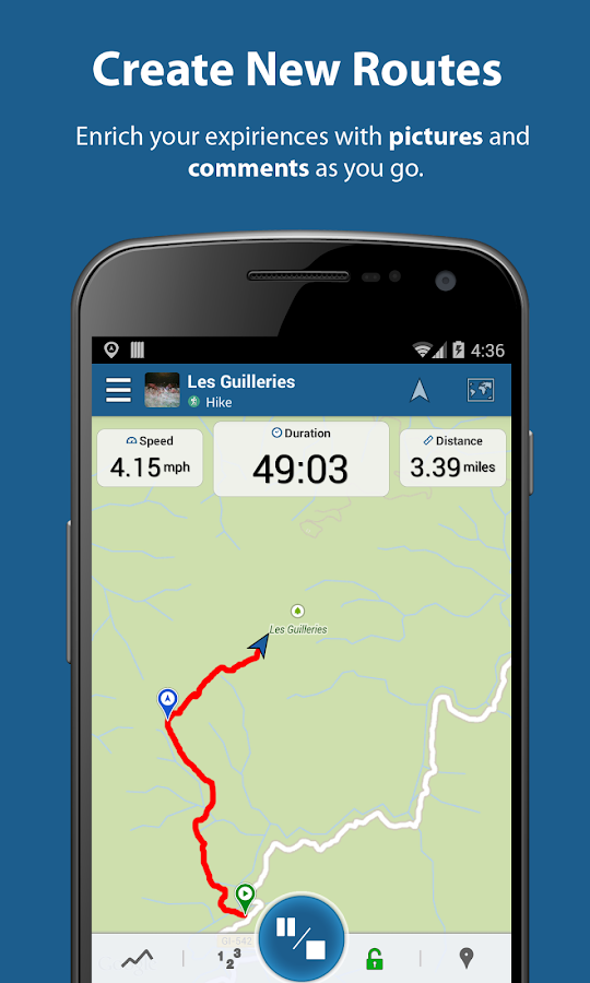
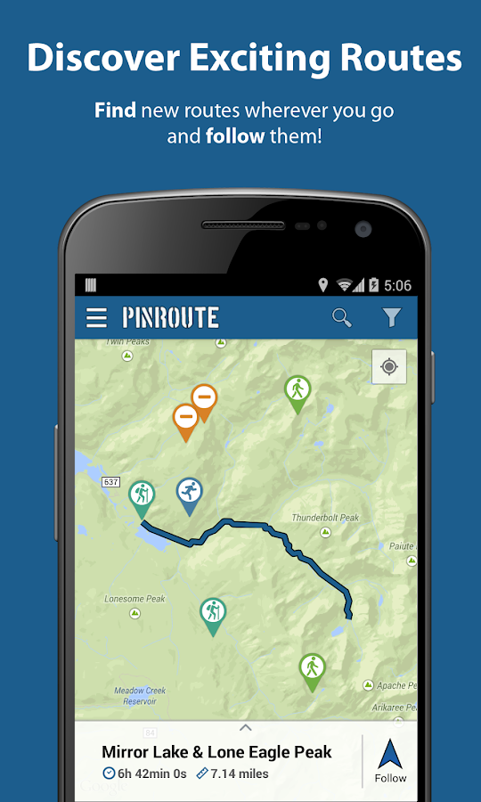
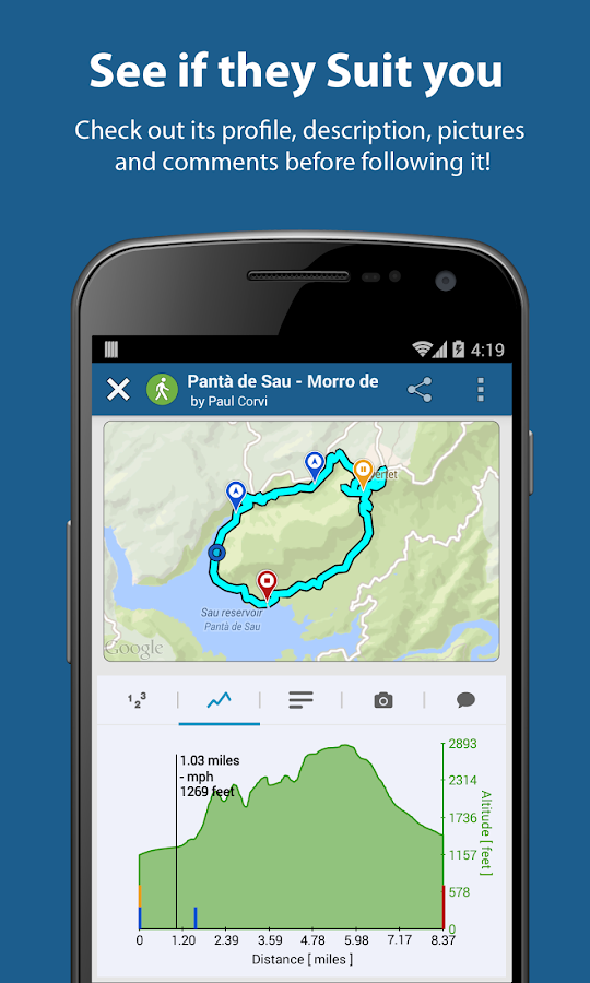
PinRoute is a route tracker app to create,search, follow and manage your favorite trails!* Great for tracking any outdoor activity: hiking, trekking,biking, walking …* Upload all your trails to the cloud.* Add pictures to your hikes, points of interest and comments asyou go and post it to Facebook if you want.* Share any trail with your friends* Are you going somewhere and need to look for a hike there? Findnew trails wherever you go, and follow them!* Write&Read reviews of your favorite hikes or routes* Checkout trail profiles (time, distance, speed, elevation,…)* Save any route to “Your tracks” and follow it later in offlinemode.* Import or export any track in GPX, KML format.* Continue or follow an existing route.* Manage all your trails also at www.pinroute.comhiking, hike tracks, trek, treking, trail, gps
Similar Apps Show More...
 2.2.8b")
AlpineQuest GPS Hiking (Lite) 2.2.8b APK
AlpineQuest Lite is the free solution forall outdoor activities and sports, including hiking, running,trailing, hunting, sailing, geocaching, off-road navigation andmuch more.You can access and store locally a large range of on-linetopographic maps, which will remain available even while beingout of cell coverage. AlpineQuest also supports on-board filebased maps, like MemoryMap(c) maps.By using the GPS and the magnetic sensor of your device (withcompass display), getting lost is part of the past: you arelocalized in real-time on the map, which can also beoriented to match where you are looking at.By staying fully operational out of cell coverage (as often inmountain or abroad), AlpineQuest assists you in all your desires ofdeep wilderness exploring...Don't hesitate, use it right now for free!PLEASE report suggestions and issues on our dedicated forumhttp://www.alpinequest.net/forum (no registration needed, allquestions answered) and not in comments.Key features (for the full/paid version) are:★★ Maps ★★• Built-in online maps (with automatic local storage;road, topo and satellite maps included);• Built-in online layers (road names and hillsshading);• Get more online maps and layers in one click from the includedcommunity map list (Nokia maps, Yahoo! Maps, local topo maps,...);• Complete area storage of online maps for off-lineuse;• On-board offline maps support (visit our website to getthe free map creator MOBAC);• Memory-Map support (QuickChart .QCT maps only, .QC3 mapsnot compatible, test your maps using the free Lite versionfirst);• Multiple maps in layers display, with per-map opacitycontrol;• Advanced SD memory card Map Explorer and Scanner.★★ Landmarks ★★• Create, display, save, restore unlimited number of waypoints,routes, areas and tracks;• Import/export GPX files, Google Earth KML/KMZfiles, CSV/TSV files;• Support OziExplorer WPT and Geocaching LOCwaypoints;• Save and share online locations with other users using CommunityLandmarks;• Details, advanced statistics and interactive graphics on variousitems;• Time Controller to replay time-tagged tracks;• Routes, tracks and areas creator;• Advanced SD memory card Landmarks Explorer.★★ GPS Position / Orientation ★★• On-map geolocation using GPS or Network;• Map orientation, compass and target finder;• Built-in GPS/Barometric track recorder (long trackingcapable, running in a separate and light process);• Proximity alerts and leave path alerts;• Barometer support (for compatible devices).★★ And more: ★★• Metric, imperial and hybrid distance units;• GPS Latitude/Longitude and grid coordinate formats (UTM, MGRS,USNG, OSGB, Irish Grid, Swiss Grid, Lambert Grids, DFCI Grid, QTHMaidenhead Locator System, ...);• Ability to import hundreds of coordinate formats fromhttp://www.spatialreference.org;• On-map grids display;• Full screen map view;• Multi-touch zoom;• ...About the "Phone state and identity" Android permission: due to thebackward compatibility of AlpineQuest with Android 1.5, thispermission is automatically added by Google Play.
Quechua Tracking 1.5.1 APK
Quechua Tracking, a new hiking experience onyour smartphone.Quechua Tracking is a must-have app, providing essential featuresto enable you to track your hikes.GPS Tracking and permanent geolocation feature for your safety, arecord chart and option to create a hiking journal that you canshare with your friends etc. Thanks to Quechua Tracking, yoursmartphone can be converted into a genuine outdoor GPS and can keepa record of all your hiking experiences.Localization system and safety:Using the collaborative map, OpenStreetMap-Landscape, Quechuaallows you to find out your GPS position, in real time, anywhere inthe world.This map is updated with new details every day, thanks to thecontributions of internet users. It also has special outdoorgraphics (with contour lines, trails, vegetation, ski-lifts,etc.)Zoom available up to a scale of approximately 1/10000m (dependingon resolution of smartphone)If you wish to provide rapid and accurate information to theemergency services about your location, in the event of anincident, you can simply send a screenshot of your position on themap by text or MMS.If you're worried about poor network coverage during your hike,Quechua Tracking includes a function that allows you to "download amap:" pay a one-off charge of EUR 1.99 (InApp Purchase) and thenyou can download, onto your mobile, the appropriate base map forthe route you wish to take.Record chart:Quechua Tracking allows you to view your activity and yourperformances: altitude, cumulative elevation gain/loss, distancecovered, climbing speed, walking time etc. This will help you focusyour efforts and improve your hiking time.Hiking Journal:Start and finish points, elevation gain/loss, route, duration,speed etc. Quechua Tracking allows you to record information aboutyour trip, combine photos and comments and create your very ownHikeBook®: a new type of hiking journal, incorporating your finestmemories.You can share photos taken during your hike, at any time onFacebook™ or e-mail your Hikebook® to selected individuals.Main functions:-GPS tracking-Geolocation and tracking on OpenStreetMap-Landscape-Share your GPS position via text or send a screenshot of your mapposition via MMS.-Downloadable map (chargeable)-"Mountain" record chart-Elevation profile-Save and share photos-Create and share a HikeBook®, a hiking journal documenting thethrill and excitement of the hiking experience

BackCountry Navigator TOPO GPS APK
Download topo maps for an offline outdoornavigator! Use your phone or tablet as an offroad topo mappinghandheld GPS with the bestselling outdoor navigation app forAndroid! Explore beyond cell coverage for hiking and otherrecreation.Download topo maps for the US and many other countries in advance,so you won't need cell coverage for navigation. Use storage memoryfor maps.New: Android Wear support to see navigation at a glance onwristUse GPS waypoints from GPX or KML files, or enter your owncoordinates using longitude/latitude, UTM, MGRS, or grid reference.Using GOTO makes a waypoint a locus for navigation.This uses many publicly available map sources as free downloads.Some additional content available as an in app purchase:-Accuterra Topo Map Source for $19.99/year. This can be purchasedand used with or in instead of the free sources.- Boundary maps for 12 western states from the Bureau of LandManagement(BLM) Overlay for topo maps valued by hunters.-GMU boundaries in some states-Lake Contours in several states.-Content from US TrailMaps including:-ATV, Whitewater, and Equestrian Trail MapsSee the menu under More-> "Purchasing AddOns". They can be shownon top of topo maps.You may try the DEMO version to make sure you like the maps in yourcountry.About topo (topographic) maps: Topo maps show terrain through colorand contours, and are useful for navigation offroad. Topo maps andGPS can be used for hiking, hunting, kayaking, snowshoeing, &backpacker trails.You can create your own maps with Mobile Atlas Creator, or specifya custom tile server. Built in sources include:OpenStreetMaps from MapQuestOpenCycleMaps showing terrain worldwideUS Topo Maps from Caltopo and the USGSUSTopo: Aerial Photography with markup.Canada Topo Maps from ToporamaMarine maps: NOAA RNC Nautical Charts (coastal)USGS Color Aerial photographyTopographic Maps of Spain and ItalyTopo maps of New ZealandJapan GSI maps.Many of the above sources are generally free to use.Use offline topo maps and GPS on hiking trails without cellservice. The GPS in your Android phone can get its position fromGPS satellites, and you don’t have to rely on your data plan to getmaps. Have more fun and safe GPS navigation in thebackcountry.Use as a geocaching navigator by getting a pocket query asGPX.Besides geocaching, use GPS for recording tracks and GPS waypointson your trip, all the while tracking your GPS quest on topographicmaps. It may replace your Garmin handheld GPS.Here are some of the outdoor GPS activities BackCountry Navigatorhas been used for:As a hiking GPS both on hiking trails and off trail.Camping trips to find that perfect camping site or the way back tocamp with GPS.Hunting trips for hunting wild game in rugged areas.Doing recon for a hunt or as your hunting GPSFishing: make it your fishing GPS.Search and Rescue (SAR).Trekking the Pacific Crest trail or other long term hiking.Kayak and canoe treks on inland lakes and streams or marine,coastal waters.Backpacker trips: using topo maps of wilderness areas and nationalforests for navigation on trails with the GPS in your rucksack orbackpack.Find your own ways to have fun in the outdoors. Be a maverick byventuring beyond cell service boundaries with your GPS. Become apro at navigation with GPS for the outdoors.BackCountry Navigator has been on WM devices and preloaded on theTrimble Nomad outdoor rugged device. This Android version is moreflexible, featured, and fun. Create a memory with maps.For a one time fee, this a great addition to the outdoor gear youbought at Cabelas, REI, or another outdoor store. Many have foundthe Android GPS in a phone or tablet to substitute for a Garmin GPSor Magellan GPS, such as the Garmin GPS units Montana, Etrex, orOregon. Android can be your handheld GPS.

AllTrails - Hiking, Trail Running & Biking Trails 11.6.3 APK
AllTrails is your guide to the outdoors!Whether you are traveling or looking to discover new trails nearby,AllTrails makes it easy to find the best trails to hike, bike, orrun.EXPLORE 50,000+ TRAILS• AllTrails has the largest collection of detailed, hand-curatedtrail maps as well as trail reviews and photos crowdsourced from acommunity of millions of hikers, mountain bikers and trail runnerslike you• Whether at home, at a National Park, or on the road, find yourperfect hike, mountain bike ride, or trail run by length, rating,and difficulty level• Filter by dog friendly, kid friendly, and wheelchair friendlytrailsSAVE YOUR FAVORITE TRAILS• Keep track of trails you want to explore, that you’ve completed,or that you simply find fun, beautiful, or inspiringRECORD YOUR ACTIVITY• Turn your phone into a GPS tracker and follow your trail so youdon’t get lost• Whether hiking, running, or biking, record your route, pace,distance, elevation, and max speed• Upload your activities to your account and share your adventureswith friends and familyDRIVING DIRECTIONS• With just one tap, get detailed driving directions so you can getto the trailhead in no timeFOLLOW FRIENDS FOR INSPIRATION• Check out where your friends have been and which trails they haverated highlyGET MORE WITH ALLTRAILS PRO• Download your maps for offline use - see where you are on the mapeven when you have no data signal through your phone’s built-inGPS• Print your maps on AllTrails.com - with customizable optionsincluding scale, gridlines, paper size, datum and topographicallayers• Create custom maps - draw your own custom routes to plan out thepath you want to take• More map layers - like Topo, Open Street Maps (OSM), Open CycleMap (OCM), and moreAllTrails Pro is available for $29.99/year. You can subscribe andpay through your Google Play account. Your subscription willautomatically renew unless cancelled at least 24 hours before theend of the current period. Auto-renew can be turned off anytime bygoing to your My Subscriptions page on Google Wallet. Access moreAllTrails Pro features on our website: http://alltrails.com---COMPATIBILITY• Sign up required to favorite trails, record your activity, orfollow users• Trails currently only available in North AmericaSUPPORTWe love hearing from our users! Email us here:[email protected] of Use: http://alltrails.com/termsPrivacy Policy: http://alltrails.com/privacy

OruxMaps 7.0.2 APK
Map viewer, track logger.You can use OruxMaps for your outdoor activities (running,trekking, mountain bike, paragliding, flying, nautic sports,etc.)Some permissions explained:1.-SEND_SMS: For new SOS feature.2.-GET_ACCOUNTS: For secure login in OruxMaps servers.3.-READ_CONTACTS: For fast friend selection.100% free100% no advertisementsOnline and offline maps. Support to multiple formats:-OruxMaps format. You can use maps from Ozi Explorer transformedwith a PC tool.-.ozf2-.img garmin (vectorial) - no full support is provided.-.mbtiles-.rmap-.map (vectorial from mapsforge). Support to custom themes similarto Locus themes.Support to Wms, you can use the application as a WMS viewer.3D view.Support to multiple external devices:-GPS bluetooth.-Heart rate monitors, bluetooth Zephyr, Polar (including bluetoothsmart devices, like polar H7).-ANT+ (speed, cadence, heart rate, distance, etc.).-AIS information systems (experimental), for nautical sports, usingWi-fi or bluetooth.More features:Support to KML, KMZ and GPX formats.Share your position with your friends, display the position of yourfriends on your device.Download online maps for offline use.Text to speech support.Profiles; save your preferences on your SD card.Statistics with graphics.Follow routes, with different alarms to alert you if you are near awaypoint, or you are far from the route.Create/save waypoints, attaching photo/audio/videoextensions.Custom waypoint types, with your icons.Basic support to Geocaching.Correct the altitude of your tracks/routes using DEM files(offline) or online services.Search/download tracks from:-everytrail.com-gpsies.comSearch or create tracks offline using Broute app.Upload tracks to:-mapmytracks.com-trainingstagebuch.org-ikimaps.com-wikirutas.com-openxplora.com-strava.com-openstreetmaps.orgLive tracking using:-mapmytracks.com-okmap application-gpsgate protocolMore info here: www.oruxmaps.com

Hiking trails 1.0.8 APK
Hiking trails is a free app to plan your hiking trips,virtuallyalmost anywhere in the world. With over 150,000 GPS tracksandwaypoints, you can search trails around you (when you arealreadyoutdoors), or you can find hiking trails near a town orcountry, tohelp you plan your trip. With the wonderfulOpenStreetMap maps, youcan view the trail path and nearby points ofinterest. Once youhave found a trail, you can download it as KMLfile, compatiblewith OruxMaps, Google MyTracks or any other GPSnavigator. Also,you can add the trail to your favorites list, toreview it wheneveryou want. FEATURES. ★ More than 150,000 trailsall around theworld, with GPS tracks and pois. ★ Search trailsbased on yourlocation. ★ Search trails by city or countries, toplan a travel. ★Descriptive information for each trail. ★ Share atrail / map withyour WhatsApp contacts, even thought if they donthave Android orHiking Trails app. ★ Unlimited trails Download inKML format,compatible with all the main GPS browsers: Orux Maps,GoogleMyTracks, Google Earth, etc. ★ Favorites lists, to review atrailwhenever you want. ★ Comment and disqus each trail(withoutregistering). ★ Locate your position on the map. COMINGSOON. ★View photos around each trail. ★ View Google Street Viewpanoramasaround each trail, if available. ★ Share lists offavorites to yourWhatsApp contacts. ★ Heat maps to see the mostpopular areas forhiking


AlpineQuest GPS Hiking APK
AlpineQuest is the complete solution forall outdoor activities and sports, including hiking, running,trailing, hunting, sailing, geocaching, off-road navigation andmuch more.You can access and store locally a large range of on-linetopographic maps, which will remain available even while beingout of cell coverage. AlpineQuest also supports on-board filebased maps, like MemoryMap(c) maps.By using the GPS and the magnetic sensor of your device (withcompass display), getting lost is part of the past: you arelocalized in real-time on the map, which can also beoriented to match where you are looking at.Save and retrieve landmarks, share them with your friends.Track your path, get advanced statistics andinteractive graphics. You won't have anymore questions aboutwhat you can accomplish.By staying fully operational out of cell coverage (as often inmountain or abroad), AlpineQuest assists you in all your desires ofdeep wilderness exploring...Don't hesitate, try the free Lite version right now!PLEASE report suggestions and issues on our dedicated forumhttp://www.alpinequest.net/forum (no registration needed, allquestions answered) and not in comments.Key features are:★★ Maps ★★• Built-in online maps (with automatic local storage;road, topo and satellite maps included);• Built-in online layers (road names and hillsshading);• Get more online maps and layers in one click from the includedcommunity map list (Nokia maps, Yahoo! Maps, local topo maps,...);• Complete area storage of online maps for off-lineuse;• On-board offline maps support (visit our website to getthe free map creator MOBAC);• Memory-Map support (QuickChart .QCT maps only, .QC3 mapsnot compatible, test your maps using the free Lite versionfirst);• Multiple maps in layers display, with per-map opacitycontrol;• Advanced SD memory card Map Explorer and Scanner.★★ Landmarks ★★• Create, display, save, restore unlimited number of waypoints,routes, areas and tracks;• Import/export GPX files, Google Earth KML/KMZfiles, CSV/TSV files;• Support OziExplorer WPT and Geocaching LOCwaypoints;• Save and share online locations with other users using CommunityLandmarks;• Details, advanced statistics and interactive graphics on variousitems;• Time Controller to replay time-tagged tracks;• Routes, tracks and areas creator;• Advanced SD memory card Landmarks Explorer.★★ GPS Position / Orientation ★★• On-map geolocation using GPS or Network;• Map orientation, compass and target finder;• Built-in GPS/Barometric track recorder (long trackingcapable, running in a separate and light process);• Proximity alerts and leave path alerts;• Barometer support (for compatible devices).★★ And more: ★★• Metric, imperial and hybrid distance units;• GPS Latitude/Longitude and grid coordinate formats (UTM, MGRS,USNG, OSGB, Irish Grid, Swiss Grid, Lambert Grids, DFCI Grid, QTHMaidenhead Locator System, ...);• Ability to import hundreds of coordinate formats fromhttp://www.spatialreference.org;• On-map grids display;• Full screen map view;• Multi-touch zoom;• ...About the "Phone state and identity" Android permission: due to thebackward compatibility of AlpineQuest with Android 1.5, thispermission is automatically added by Google Play.

Backpacker GPS Trails Lite 5.7.1 APK
Backpacker’s GPS Trails Lite doubles as aportable trip database and personal navigation device for youroutdoor lifestyle: hiking, backpacking, camping, mountaineering, orfor just basic trail navigation. GPS Trails Lite works in remoteplaces like national parks, wilderness areas, and backcountry spotswithout relying on data and cell signals.-----UPGRADE TO PROTry the free app then upgrade to GPS Trails Pro for even morefeatures, including:* Create map packs to store maps on your phone. This app allowsyou to save topos (MyTopo), aerials (Bing), streets (OSM), andterrain (OCM) map types.* Get worldwide aerial images on your phone. Our app gives you rareaccess to view and store offine aerial imagery from Bingmaps.* Shoot video and geotag it to an exact location on a map. Savevideos to YouTube account.* Convert lat/long coordinates to UTM and NAD 27 map datum to syncwith paper maps for advanced navigation in the field.* No ads. Say goodbye to advertisements that occupy valuable screenspace for navigating.--------With GPS Trails Lite, you can:Turn your phone into a GPS: Navigate via precise satellitesignals in and out of cell network.Capture waypoints: Mark campsites, trailheads, water sources,summits, and more.Track every step: Record or follow your tracks and routes. Seecompass essentials too.Share your trip: Post adventures to trimbleoutdoors.com, Twitterand Facebook.View maps: See street maps, aerial photos, hybrid street/aerialmaps, and topo maps provided by MyTopo. Please note: Upgrade to GPSTrails Pro to store maps on your Android phone.View stats: See 10 stats, including elevation, speed, anddistance.Download Pro Trips: Follow our step-by-step trail guides ofpopular trails and lesser-known routes in national parks, nationalforests, and local parks, including Yellowstone, Yosemite, GrandCanyon, Great Smoky Mountains, Glacier, Rocky Mountain, WhiteMountains, Adirondacks, Catskills, Zion, Arches, Canyonlands,Acadia, Mount Rainier, Everglades, Olympic, and more. Find hikesnear major cities: New York City, Seattle, Portland, LA, Denver,Chicago, Boston, Atlanta, and more. Plus find section hikes on theAppalachian Trail, Pacific Crest Trail, and the Continental DivideTrail.Search trips: Find thousands of trips shared by the Backpackereditors and the trimbleoutdoors.com community.Plan trips: Plan trips with map tools at trimbleoutdoors.com andwirelessly sync them to Backpacker GPS Trails app. You can markpoints, draw tracks, upload GPS files, print maps, and more.(requires membership)Get published: Every month the editors at Backpacker handpickadventures shared by its online community to be published in themagazine. Kickstart your adventure writing and photography careerwith GPS Trails.NEW: Plug in statewide topo maps into your Android with our newSD cards. Learn more at: http://www.trimbleoutdoors.com/SDCards/MORE INFOSupported Phones: GPS Trails Lite is designed and optimized for theAndroid phones.Battery Life: While we optimize our code to cut down on powerrequirements, continued use of the GPS running in the backgroundcan dramatically decrease battery life. For longer dayhikes orovernight trips, we suggest packing lightweight battery packs.Follow Us: We’ve created a Facebook page for our apps. Yourfeedback helps us create a better app. Go to:facebook.com/backpackergpstrails.Backpacker brings the outdoors straight to the reader'sdoorstep, inspiring and enabling them to go more places and enjoynature more often. The authority on active adventure, Backpacker isthe world's first GPS-enabled™ magazine and website, and the onlyoutdoor media whose editors and network of map contributorspersonally map the hiking trails they publish.
Travel & Local Top Show More...

Flightradar24 - Flight Tracker 6.7.1 APK
Turn your phone or tablet into anairtrafficradar and see planes around the world move in real-timeonadetailed map. Or point your Android device at a plane in theskytofind out where it’s going and more. Discover today whymillionsarealready using Flightradar24 - Flight Tracker.Features that have helped make Flightradar24 - FlightTrackerthe#1 selling app in 100+ countries and the #1 Travel appin140+countries (United States, France, United Kingdom, Germanyandmore)include:* Watch planes move in real-time on detailed map* Identify planes flying overhead by simply pointing yourdeviceatthe sky (the augmented reality view requiresrearcamera,accelerometer & magnetic sensor)* Experience what the pilot of a an aircraft sees in real-timeandin3D* Tap on a plane for comprehensive flight andaircraftinformationsuch as route, estimated time of arrival, actualtime ofdeparture,aircraft type, speed, altitude, andhigh-resolutionpicture* Easy to search for individual flights using flightnumber,airport,or airline* Easy to filter by airline, aircraft, altitude,speed,andmore* Easy to set bookmarks to enable quick navigation toareasofinterest* Turn the device into the arrivals and departures board ofanymajorairport and get real-time status updates for flightspluscurrentairport weather conditions (in-app purchase)* Realistic aircraft symbols (in-app purchase)* Set up custom alerts based on airline, aircraft type,flightnumberor registration (in-app purchase)HOW IT WORKSMost aircraft are equipped with so called ADS-Btranspondersthattransmit positional data. Flightradar24 has arapidlygrowingnetwork of several thousand ground stations aroundthe worldtoreceive this data that then shows up as aircraft movingon a mapinthe app. In an expanding number of regions Flightradar24,withthehelp of multilateration, is able to calculate thepositionsofaircraft that don’t have ADS-B transponders.Traditional radar data is also used in the app thanks toadirectfeed from the US Federal Aviation Administration (FAA).http://www.flightradar24.com/how-it-works***IMPORTANT NOTICES***Minimum required screen resolution is 320x480px.If you are only interested in tracking air traffic inaspecificregion, we suggest that you checkFlightradar24.comBEFOREpurchasing the app. Flightradar24 providesunrivaledpositionalaircraft data coverage around the world butthere areareas wherewe don’t have coverage.Overview of coverage as of January 2016:* Europe: close to 100%* North America: 100% of US and Canada via slightlydelayedradardata. Real-time coverage for most of US, Canada andMexicoforADS-B equipped aircraft* South America: Substantial coverage in mostcountriesincludingArgentina, Bolivia, Brazil, Chile, Colombia,EcuadorandVenezuela.* Asia: Substantial coverage in most major AsiancountriesincludingJapan, India, Indonesia, South Korea, Thailand,UAE,Malaysia,Taiwan and many other countries. Rapidlyexpandingcoverage inChina* Oceania: Nearly complete coverage in AustraliaandNewZealand* Africa: Substantial coverage in Africa with coverageexpandingallthe time.Find out how you can help:http://www.flightradar24.com/increase-coverageCoverage is subject to change at any time.HELP & SUPPORTforum.flightradar24.com/threads/89-Important-Read-this-before-you-ask-questionsflightradar24.com/contact-us.DISCLAIMERThe use of this app is strictly limited toentertainmentpurposes.This specifically excludes activities thatmight endangeryourselfor the lives of others. Under nocircumstances will thedeveloperof this app be held responsible forincidents resultingfrom theuse of the data or its interpretation orits use contraryto thisagreement. We reserve the right toanonymously track andreport auser's activity inside of app.

MOFA KSA 2.5.5 APK
يعد تطبيق وزارة الخارجيةالسعوديةللأجهزةالذكيةهو أحد قنوات الوصول لخدمات الوزارة والتي منخلالهيمكن تنفيذمجموعةمن الخدمات التي تستهدف شرائح مختلفة منالمستفيدين(أفراد،أعمال،وحكومة) كما يتم تحديث التطبيق بشكل دوريبمجموعة منالخدماتالجديدةوالتحسينات التي من شانها رفع مستوى الرضالدىالمستفيدين منخدماتالوزارة.تنفيذ وتطوير التطبيق:تم تطوير التطبيق من قبل الإدارةالعامةلتقنيةالمعلوماتوالاتصالاتالدعم الفني والاقتراحات:يرجى تعبئة الاستبيان الموجود ضمن مشاركاتإلكترونية-استبيانتطبيقالأجهزة الذكية أو مراسلتناعلىالبريدالإلكتروني[email protected]

MakeMyTrip Hotel Extranet 5.0.0 APK
Hoteliers, this one is foryou!MakeMyTrippresents the exclusive Hotel Extranet mobileappspecially designedto keep your hotel details up-to-date.With this app, you can:• Have access to day-wise / calendar view of your hotelrates&inventory• Update your hotel rates & inventory day-wise as well asforalonger period of time• Update ALL your tariffs’ inventory in just 2 steps• Track your important business metrics(likeCheck-InsToday/Tomorrow, Room Night Check-Ins in next 30 days,SoldOut innext 90 days etc.)• Keep a track of all your bookings & also takenecessaryactionslike Confirm a booking, Mark Check-In/No Show fora Pay AtHotelbooking• View complete details of a booking (including the voucher)• Call a Pay At Hotel customer with a single tap• Manage your Hotel Promotions in quick & easy waywithanability to create new promotions• Keep a track of your Payments• View help video tutorials to understand the utilityofourapp• Push Notifications to help you with Sold Out days &summaryofyour BookingsHotel Extranet will set you free from long chain mailsandphonecalls. No matter where you are, you can keep yourhoteldetailsfresh within a few easy steps.Also, there is lot more to come, which will make yourlifeeveneasier!

hottel - Hotel Booking 4.1.20 APK
Everyday hotels give us last-minutediscountsontheir available rooms.Best prices are guaranteed.Hotels are hand-picked to meet your expectation.10 seconds to book a roomPay less enjoy more.8:00 - 24:00 every night we are ready.Contact [email protected]