
/ Dec 13, 2022

Description
App Information AxiKit Accident Report System
- App NameAxiKit Accident Report System
- Package Namecom.axikit.axikit
- UpdatedDec 13, 2022
- File SizeUndefined
- Requires AndroidAndroid
- Version
- DeveloperAxiKit
- Installs5K+
- PriceFree
- Categoryflag</i>Flag as inappropriate</a></div></section></div></div><div class="o45e4d"><c-wiz jsrenderer="Grlxwe" jsshadow jsdata="deferred-i18" data-p="%[email protected],true]" data-node-index="5;0" autoupdate jsmodel="hc6Ubd" c-wiz><section class="HcyOxe" jscontroller="NkbkFd"><header class=""><div class="VMq4uf" id="developer-contacts-heading"><div class="EaMWib"><h2 class="XfZNbf">Developer contact</h2></div><div jsaction="JIbuQc:Ptdedd"><button class="VfPpkd-Bz112c-LgbsSe yHy1rc eT1oJ mN1ivc VxpoF" jscontroller="soHxf" jsaction="click:cOuCgd; mousedown:UX7yZ; mouseup:lbsD7e; mouseenter:tfO1Yc; mouseleave:JywGue; touchstart:p6p2H; touchmove:FwuNnf; touchend:yfqBxc; touchcancel:JMtRjd; focus:AHmuwe; blur:O22p3e; contextmenu:mg9Pef;mlnRJb:fLiPzd;" data-disable-idom="true" aria-label="Expand" aria-controls="developer-contacts" aria-expanded="false"><div jsname="s3Eaab" class="VfPpkd-Bz112c-Jh9lGc"></div><div class="VfPpkd-Bz112c-J1Ukfc-LhBDec"></div><i class="google-material-icons VfPpkd-kBDsod W7A5Qb" aria-hidden="true">expand_more</i></button></div></div></header><div class="SfzRHd jqSImf" role="region" id="developer-contacts" aria-labelledby="developer-contacts-heading"><div class="vfQhrf BxIr0d"><div class="VfPpkd-WsjYwc VfPpkd-WsjYwc-OWXEXe-INsAgc KC1dQ Usd1Ac AaN0Dd VVmwY"><div class="VfPpkd-EScbFb-JIbuQc" jscontroller="tKHFxf" jsaction="click:cOuCgd; mousedown:UX7yZ; mouseup:lbsD7e; mouseenter:tfO1Yc; mouseleave:JywGue; touchstart:p6p2H; touchmove:FwuNnf; touchend:yfqBxc; touchcancel:JMtRjd; focus:AHmuwe; blur:O22p3e; contextmenu:mg9Pef;"><a class="Si6A0c RrSxVb" target="_blank" href="http://www.axikit.com"><i class="google-material-icons j25Vu" aria-hidden="true">language</i><div class="pZ8Djf"><div class="xFVDSb">Website</div><div class="pSEeg">http://www.axikit.com</div></div></a><div class="VfPpkd-FJ5hab"></div></div><span class="VfPpkd-BFbNVe-bF1uUb NZp2ef" aria-hidden="true">
- DeveloperBox 32321 Baltimore, MD 21282
- Google Play Link
AxiKit Show More...

AxiKit Accident Report Kit APK
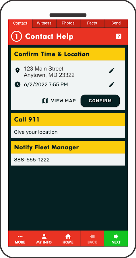
Protect yourself, your family or your businessfleet with AxiKit. It’s the easiest, most effective accident appfrom the leader in accident report kits. REQUIRES ACTIVATION CODE(SEE BELOW)Accidents happen without warning. If you’re unprepared, even aminor accident can turn into an expensive nightmare. No matterwho’s at fault, you could become a victim of fraud and inflatedclaims.AxiKit guides you step by step so you'll know what to say anddo. It uses a unique system of organized voice recordings andphotos, so you can easily capture vital information and valuableevidence at the accident scene. Everything is saved to a report youcan email to yourself or others.Download now for peace of mind later! REQUIRES ACTIVATION CODE(SEE BELOW)FEATURES:• Accurate voice recordings eliminate the errors & hassle oftyping
• Capture valuable witness statements in their own voice
• Signature capture Release Form helps prove your case if otherdriver admits fault• Built-in map automatically pinpoints accident location date andtime• Photo checklist helps you capture all vital images of thescene• Notify emergency services and your personal contact at the touchof a button• Produces a detailed report with photos, voice recordings, and allcrucial information• Report can be easily emailed to yourself, insurance orothers
• Easily exchange information with quick email featurePLEASE NOTE - REQUIRES ACTIVATION CODE. Codes are given tovalued customers by insurance companies, collision centers, andother auto service providers. Check with your local provider. Touse in demo mode enter code "DEMO" at start.TO REQUEST AN ACTIVATION CODE email us at [email protected], comments, or suggestions? We value your feedback!Please email us at [email protected]

Similar Apps Show More...


")

SalesMasterMap - Field Service Mobile 3.8.04.08 APK
Field Services Field service management - Scheduling,dispatchingIncrease productivity and profits by fitting in morejobs per daywith optimized routes Sales Master Map - the maps youcreate can beeasily accessed and viewed on any desktop, smartphoneor tabletdevices. Door-to-Door Salesman map. See all of your Leadsin salesmap. Canvassing and sales is now easy as it should. Addyourclients on the map. Perfect app for sales managers. Salesmastermap it is location map with full support for clould.Multiplemarkers, multiple maps, multiple devices (pc, smartphone,tablet,Mac). Multi waypoint route planner easy to use. A Batch Geomobilealternative. Create maps for your sales team via WWW andaccess viasmartphone smoothly. Plan all your routes and adventuresinstantlyon your smartphone or tablet using the Sales Master Mapapp. Getthe power of online mapping technology right on your phone,tablet,Mac and PC. Visualize your data (sales, customer,competitor)faster, save it on your mobile device and access theaddress listand maps from anywhere. Create groups of locations andidentifybusiness trends. Divide your data into groups (sets of datawhosevalues fall into specific categories) and set each group toadifferent color. Door-to-door canvassing campaigns on yourmobilephone Add your customers to location map. - integration withGoogleNavigation - pinpoint location easily - check coverage inyour area- sales territory map with location map - plot multiplelocation ona map - add, move and delete markers manually - editmarker title,description and group - 2000 markers per map - 9predefined markergroups - you can add photos to every pin Locationmap easy-to-use.Door-to-Door Sales app.


ADSB Receiver Pro 4.8.0 APK
The leading ADSB Receiver for Android!! ** Please note: -YOU NEEDADDITIONAL HARDWARE TO USE THIS APP. -Disable battery optimizationif run in background. This app enables your device to receive liveADSB data (978 MHz UAT and 1090 MHz ES). All you need is asupported USB dongle and an OTG cable, both available from varioussources on the internet for less than $20.-. No subscriptionrequired! Follow this link for more details:http://hiz.ch/index.php/home/adsb-receiver Use this app to providelive ADSB data to Avare! All data received (traffic, Nexrad weatherand standard reports like METAR, TAF, PIREP, WINDS, ...) will bemade available automatically, once Avare has been detected. (Makesure to enable "Use ADSB Weather" in Avare.) Download Avare here,it's free:https://play.google.com/store/apps/details?id=com.ds.avare You canalso forward the data to most GDL90 compatible apps like iFlyGPS,FltPlanGo, DroidEFB, ... USAGE Attach a supported USB dongle toyour Android device by using an OnTheGo (OTG) cable/adapter. Makesure your device supports OTG! Start the app and allow access tothe dongle. You should see packages flowing in quickly, dependingon your location. HARDWARE Supported tuners: Rafael Micro R820T andR820T2. List of example dongles and OTG adapters/cables:http://hiz.ch/index.php/home/adsb-receiver#HARDWARE AUTHOR HIZ LLC,Michael Hammer Copyright (C) 2014-2020, all rights reservedDISCLAIMER THIS SOFTWARE IS PROVIDED BY THE COPYRIGHT HOLDERS ANDCONTRIBUTORS "AS IS" AND ANY EXPRESS OR IMPLIED WARRANTIES,INCLUDING, BUT NOT LIMITED TO, THE IMPLIED WARRANTIES OFMERCHANTABILITY AND FITNESS FOR A PARTICULAR PURPOSE AREDISCLAIMED. IN NO EVENT SHALL THE COPYRIGHT HOLDER OR CONTRIBUTORSBE LIABLE FOR ANY DIRECT, INDIRECT, INCIDENTAL, SPECIAL, EXEMPLARY,OR CONSEQUENTIAL DAMAGES (INCLUDING, BUT NOT LIMITED TO,PROCUREMENT OF SUBSTITUTE GOODS OR SERVICES; LOSS OF USE, DATA, ORPROFITS; OR BUSINESS INTERRUPTION) HOWEVER CAUSED AND ON ANY THEORYOF LIABILITY, WHETHER IN CONTRACT, STRICT LIABILITY, OR TORT(INCLUDING NEGLIGENCE OR OTHERWISE) ARISING IN ANY WAY OUT OF THEUSE OF THIS SOFTWARE, EVEN IF ADVISED OF THE POSSIBILITY OF SUCHDAMAGE.


CartoDruid - GIS offline tool 0.60.16 APK
CartoDruid is a GIS application developed by Instituto TecnológicoAgrario de Castilla y León (ITACyL) thought as a tool to supportthe fieldwork aiming to solve the problem of disconnected editingof georeferenced information. In many field areas, mobile coverageis insufficient to work in a reliable way. CartoDruid provides asolution to this problem allowing the visualization on raster andvectorial layers stored on the device and allowing the creation ofnew geometries (entities), drawing them directly on the screen orusing embeded or external GPS. CartoDruid doesn't requiere previousGIS (Geographic Information Systems) knowledge and it's easy toconfigure and use. This allows any person to use it to managefieldwork information and then export generated data to use them inexternal applications. What can CartoDruid do?: - Visualize onlineGoogle Maps. - Use vectorial cartography loaded on a SpatiaLitedatabase. - USe rasterimaginery loaded on a RasterLite database. -Consume online WMS services. - Create new layers on the device. -Configure filtering on vectorial layers to determine visiblegeometries based on their attributes. - Configure symbologies andlabels based on SQL expressions (easily). - Configure searches onlayers using SQL queries. - Configure identification forms based onSQL queries. - Edit the attributes of a geometry. - Manually drawgeometries: points, lines and polygons. - Draw and edit geometriesbased on GPS data. - Edit geometries using several useful tools:split using polyline, circular split, merge geometries, multipartexplosion. Graphically move existing vertices of geometries. -Create new geometries intersecting layers. - Automatically savegeorreferenced data: creating and update dates and others. -Associate pictures to entities. - SIGPAC search based on existingdownloaded data. - Length and area measurement tools, defining themeasurement units. - Guided and line based navigation to help theuser reach her destination. - Manage bookmarks. - Import vectorialdata using CSV files. - Import SpatiaLite databases. - Exportseveral formats: SQLite, KML and CSV. - TOC (Table of Contents)management: sorting, symbologies, hierarchical sorting (folders). -Works with SHP (ESRI ShapeFile) as an exprimental feature. -Controlling the operations that can be performed on a layer viaconfiguration (overlaps. move vertices. delete entities,identification and edition, ...) Go visit www.cartodruid.es to seethe complete list, download examples and learn how to start!