hourglass_full Your download should start automatically in a few seconds...

Download 自転車NAVITIME(ナビタイム)-ナビ・ルート検索・ログ_Latest Version.apk from Apk-Dl Server
Thank you for using Apk-Dl.com to download the apk file (自転車NAVITIME(ナビタイム)-ナビ・ルート検索・ログ_Latest Version.apk),
If the download doesn't start automatically in a few seconds, please click here to access the download URL directly.
Note: Download and save the apk file to your Android Phone's SD card and install it manually onto the Android device.


Description
■■ サイクリングをもっと快適に! ■■
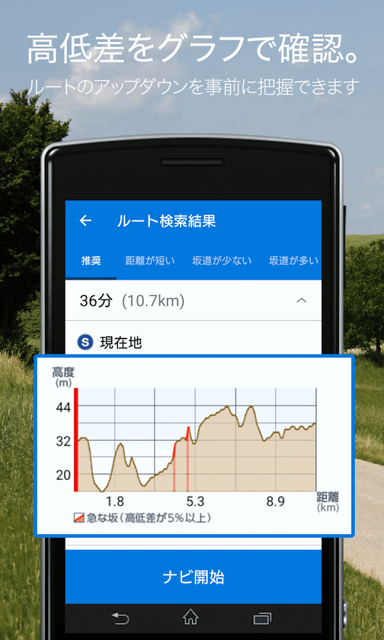
音声案内やルートの高低差グラフなど、自転車に特化したナビ機能。また650万件のスポット情報から周辺の自転車ショップやコンビニを検索できたりと、お出かけ先でも便利な機能を搭載しています。
自転車アプリで迷ったら、まずは自転車NAVITIMEをお試しください!
+++++++++++++++++++++++++++++
★無料で使える機能
◆[ルート検索(1種類)] 推奨ルートを無料で検索することができます。
◆[高低差グラフ] 高低差グラフを表示し、ルートの起伏を一目で確認することができます。また走行中は自分が高低差グラフ中のどのあたりにいるか確認できるため、適切なギアチェンジやペース配分などを考える際にも便利です。
◆[音声ナビゲーション(制限あり)] 月間10kmまで無料でご利用になれます。
◆[Android Wear端末と連携] お使いのスマートフォンとAndroidWear端末が連携した状態でナビゲーションを開始すると、音声案内時に、AndroidWear端末にもお知らせ(通知)が届きます。スマートフォンを取りださなくても、手もとで案内情報が見られますので便利です。
◆[周辺から地点検索] 全国650万の地点情報から、現在地周辺5kmのスポットを検索できます。
◆[自宅登録] 自宅の位置が登録できます。登録すると自宅へ帰るルートをワンタッチで検索できる他、自宅からのルートも簡単に検索できます。
◆[サイクリングロード特集] 全国の人気サイクリングロードをピックアップし、コース全体図や立ち寄りスポットを写真付きで紹介しています。(※掲載コースは「掲載サイクリングロード」の項目をご確認ください)
◆[夜でも見やすい地図] 昼と夜で地図の配色が自動で切り替わります。どちらかに固定することも可能です。
◆[電子コンパス] 現在地の矢印が端末の向きに合わせて回転する固定モード、地図が端末の向きに合わせて回転する回転モードの2種類のモードが利用可能です。
★プレミアムコースで使える機能(月額300円)
◆[ルート検索(7種類)] 出発地と目的地だけでなく、経由地も指定したルート検索ができます。以下の7つのルートをオプションとして表示します。
・推奨ルート(※1)
・距離が短い
・坂道が少ない
・坂道が多い
・大通り優先
・裏通り優先
・サイクリングロード優先(※2)
※1「推奨」とは、距離・時間・高低差などを考慮した自転車で走りやすいルートです。
※2「サイクリングロード優先」とは、サイクリングロードが近くにある場合、優先的に通るルートです。
◆[音声ナビゲーション(制限なし)] 距離制限なしで音声ナビゲーションをご利用になれます。
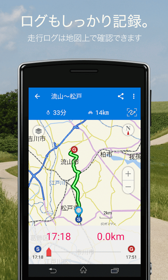
◆[走行ログ機能] 走行したルートや距離、消費カロリーなどを記録・閲覧できる機能です。ログは、月次カレンダーと日次リストで見ることができます。実際に自転車で走ったルートが速度に応じて色分けされて表示されます。また、お気に入りのサイクリングルートを簡単に友人や仲間にシェアすることも可能です。最大6時間まで連続保存できます。
◆[My地点] お気に入りの地点を保存することができます。
◆[ルート履歴] 検索したルートの履歴を最大10件まで保存することができます。
★プレミアムコース
・料金:月額300円(税込)
・docomo spモードとSoftBankまとめて支払い、Googleウォレット決済によりご利用になれます。
・「auスマートパス」をご利用の方は「au Market」の「自転車NAVITIME forauスマートパス」でも同様の機能をお使いいただけます。
・プレミアムコース登録した後に自転車NAVITIMEアプリを削除して再インストールされた場合、登録状態の復元が必要になります。詳しくは[MENU]>[会員登録/解除]>[会員状態の復元/引継ぎ]よりご確認ください。
★掲載サイクリングロード
ちば里山若葉コース、ちばベイサイド美浜コース、Cycle Aid Japan2013(全12コース)、瀬戸内しまなみ海道、安芸灘とびしま海道、荒川サイクリングロード、江戸川サイクリングロード、多摩川サイクリングロード
★ご注意
・ルート検索で使用する道路情報は、自動車用のものを基にしています。自転車では通行しづらいルートを案内する場合がありますが、必ず交通規制に従って走行してください。自転車用の道路情報の整備は随時進めており、ルートについても改善予定です。
・設定した出発/目的地によってはサイクリングロードを通る経路が表示されない場合もございます。
・地図のスクロールができない場合、下記の設定をご確認ください。
1.端末の「設定」より「開発者向けオプション」をタップする
2.次ページで「GPUレンダリングを使用」をOFFに設定する
★動作確認済み機種
Android 4.1以上の端末
※WIFI専用モデルについてはお客様の通信環境によって動作が安定しない可能性があるため本サービスでは動作保証しておりません。
※GPSデバイスが搭載されていないモデルの場合、自位置の捕捉ができないため、現在地地図の表示やナビゲーションなど、一部の機能がご利用になれない状況です。
音声案内やルートの高低差グラフなど、自転車に特化したナビ機能。また650万件のスポット情報から周辺の自転車ショップやコンビニを検索できたりと、お出かけ先でも便利な機能を搭載しています。
自転車アプリで迷ったら、まずは自転車NAVITIMEをお試しください!
+++++++++++++++++++++++++++++
★無料で使える機能
◆[ルート検索(1種類)] 推奨ルートを無料で検索することができます。
◆[高低差グラフ] 高低差グラフを表示し、ルートの起伏を一目で確認することができます。また走行中は自分が高低差グラフ中のどのあたりにいるか確認できるため、適切なギアチェンジやペース配分などを考える際にも便利です。
◆[音声ナビゲーション(制限あり)] 月間10kmまで無料でご利用になれます。
◆[Android Wear端末と連携] お使いのスマートフォンとAndroidWear端末が連携した状態でナビゲーションを開始すると、音声案内時に、AndroidWear端末にもお知らせ(通知)が届きます。スマートフォンを取りださなくても、手もとで案内情報が見られますので便利です。
◆[周辺から地点検索] 全国650万の地点情報から、現在地周辺5kmのスポットを検索できます。
◆[自宅登録] 自宅の位置が登録できます。登録すると自宅へ帰るルートをワンタッチで検索できる他、自宅からのルートも簡単に検索できます。
◆[サイクリングロード特集] 全国の人気サイクリングロードをピックアップし、コース全体図や立ち寄りスポットを写真付きで紹介しています。(※掲載コースは「掲載サイクリングロード」の項目をご確認ください)
◆[夜でも見やすい地図] 昼と夜で地図の配色が自動で切り替わります。どちらかに固定することも可能です。
◆[電子コンパス] 現在地の矢印が端末の向きに合わせて回転する固定モード、地図が端末の向きに合わせて回転する回転モードの2種類のモードが利用可能です。
★プレミアムコースで使える機能(月額300円)
◆[ルート検索(7種類)] 出発地と目的地だけでなく、経由地も指定したルート検索ができます。以下の7つのルートをオプションとして表示します。
・推奨ルート(※1)
・距離が短い
・坂道が少ない
・坂道が多い
・大通り優先
・裏通り優先
・サイクリングロード優先(※2)
※1「推奨」とは、距離・時間・高低差などを考慮した自転車で走りやすいルートです。
※2「サイクリングロード優先」とは、サイクリングロードが近くにある場合、優先的に通るルートです。
◆[音声ナビゲーション(制限なし)] 距離制限なしで音声ナビゲーションをご利用になれます。
◆[走行ログ機能] 走行したルートや距離、消費カロリーなどを記録・閲覧できる機能です。ログは、月次カレンダーと日次リストで見ることができます。実際に自転車で走ったルートが速度に応じて色分けされて表示されます。また、お気に入りのサイクリングルートを簡単に友人や仲間にシェアすることも可能です。最大6時間まで連続保存できます。
◆[My地点] お気に入りの地点を保存することができます。
◆[ルート履歴] 検索したルートの履歴を最大10件まで保存することができます。
★プレミアムコース
・料金:月額300円(税込)
・docomo spモードとSoftBankまとめて支払い、Googleウォレット決済によりご利用になれます。
・「auスマートパス」をご利用の方は「au Market」の「自転車NAVITIME forauスマートパス」でも同様の機能をお使いいただけます。
・プレミアムコース登録した後に自転車NAVITIMEアプリを削除して再インストールされた場合、登録状態の復元が必要になります。詳しくは[MENU]>[会員登録/解除]>[会員状態の復元/引継ぎ]よりご確認ください。
★掲載サイクリングロード
ちば里山若葉コース、ちばベイサイド美浜コース、Cycle Aid Japan2013(全12コース)、瀬戸内しまなみ海道、安芸灘とびしま海道、荒川サイクリングロード、江戸川サイクリングロード、多摩川サイクリングロード
★ご注意
・ルート検索で使用する道路情報は、自動車用のものを基にしています。自転車では通行しづらいルートを案内する場合がありますが、必ず交通規制に従って走行してください。自転車用の道路情報の整備は随時進めており、ルートについても改善予定です。
・設定した出発/目的地によってはサイクリングロードを通る経路が表示されない場合もございます。
・地図のスクロールができない場合、下記の設定をご確認ください。
1.端末の「設定」より「開発者向けオプション」をタップする
2.次ページで「GPUレンダリングを使用」をOFFに設定する
★動作確認済み機種
Android 4.1以上の端末
※WIFI専用モデルについてはお客様の通信環境によって動作が安定しない可能性があるため本サービスでは動作保証しておりません。
※GPSデバイスが搭載されていないモデルの場合、自位置の捕捉ができないため、現在地地図の表示やナビゲーションなど、一部の機能がご利用になれない状況です。
■■cycling more comfortable! ■■
Such as the height difference graph of the voice guidance androute, the navigation function that specializes in bicycle. Alsowith or can find a bicycle shop and convenience stores of around650 million cases of spot information, it is equipped with a usefulfunction in outing.
Once lost in the bike app, First of all, please try the bicycleNAVITIME!
+++++++++++++++++++++++++++++
★ function that can be used for free
◆ [root search (one)] You can search for a recommended route forfree.
◆ to display the height difference graph] height difference graph,you can see the relief of the route at a glance. Also while drivingbecause you can see if they are in any per during the heightdifference graph, it is also useful when considering such as asuitable gear change and pace.
◆ will be available in the voice navigation (limited)] month 10kmfree up.
◆ If [Android Wear terminal and cooperation] your smartphone andAndroid Wear terminal starts navigation in a state of cooperation,at the time of the voice guidance, also notice (notification) toAndroid Wear terminal you will receive. Even if not taken out thesmartphone, it is useful because it is seen guidance information athand.
◆ From the point search from the peripheral] point informationacross the country 6.5 million, you can find the current locationaround 5km spot.
◆ [home registration] home of the position can be registered. Otheryou can find the route to return to the home when you register atthe touch of a button, you can easily find directions from yourhome.
◆ to pick up a popular cycling load of [cycling load Feature: thewhole country, we introduce an overall view and drop spot coursewith photos. (Please check the items in the "posted Cycling Road"published course ※)
◆ [easy-to-read map at night] day and night at the map color schemewill change automatically. It is also possible to fix either.
◆ fixed mode of [electronic compass] the current location of thearrow to rotate to match the orientation of the terminal, the mapis available in two modes of rotation mode that rotates accordingto the orientation of the terminal.
★ function that can be used in premium Course(300 yen per month)
◆ [root search (seven)] not only the starting point anddestination, you can route search you also specify a stopover.Displays the following seven routes as options.
- Recommended route (※ 1)
And distance is short
- Is less slope
- There are many slopes
- Boulevard priority
· Alley priority
Cycling Road priority (※ 2)
※ 1 and "recommended" is easy to run routes, such as distance,time, and height difference in the bicycle taken intoconsideration.
※ 2 as "cycling road priority" when cycling road is near, is aroute through to the priority.
◆ will be available in all voice navigation without [voicenavigation (no limit)] distance limit.
◆ [running log function] traveling the route and distance, it is arecord-browsing can function and calories burned. Log, it can beseen on a monthly calendar and a daily list. Route ran actually onthe bike will be displayed in color-coded depending on the speed.In addition, it is also possible to share easily friends and fellowfavorite cycling route. You can continuously store up to 6hours.
◆ You can save the [My point] favorite point.
◆ [root history] the history of the search routes can be stored forup to maximum of 10.
★ premium course
- Fee: monthly 300 yen (tax included)
· Docomo sp mode and SoftBank collectively pay, it will beavailable by the Google Wallet settlement.
· If you use the "au Smart Pass" is you can use the same functionseven "bicycle NAVITIME for au Smart Pass" of the "au Market".
Premium if the course has been remove and reinstall the bicycleNAVITIME app after registering, you will need to restore theregistration status. Please check than [MENU]> [memberregistration / cancellation]> [of the member state restoration /takeover] for details.
★ posted cycling load
Chiba satoyama Wakaba course, Chiba Bayside Mihama course, CycleAid Japan 2013 (all 12 courses), Setouchi Shimanami, AkinadaTobishima Hokkaido, Arakawa cycling road, Edogawa cycling road,Tama Cycling Road
★ Please note
And road information to be used in the root search, based on thingsautomotive. The bike you might want to guide the traffic anddifficult route, but be sure to please traveling according totraffic regulations. Maintenance of road information for a bicycleis promoted from time to time, is the improvement will alsoroot.
Depending on and set the starting / destination we may path throughthe cycling road is not displayed.
• If you can not scroll the map, please check the followingsettings.
1. Tap the "Developer options" from "Settings" in theterminal
2. Set to OFF "Using the GPU rendering" in the next page
★ Tested models
Android 4.1 or more terminals
※ For WIFI-only model does not work guaranteed in this service forthe operation by the customers of the communication environmentmight not be stable.
※ In the case of the model GPS device is not installed, becausethey can not be captured in the current position, such as thedisplay and navigation of the current location map, it is asituation in which part of the function is notavailable.