hourglass_full Your download should start automatically in a few seconds...

Download BackCountry Navigator TOPO GPS_Latest Version.apk from Apk-Dl Server
Thank you for using Apk-Dl.com to download the apk file (BackCountry Navigator TOPO GPS_Latest Version.apk),
If the download doesn't start automatically in a few seconds, please click here to access the download URL directly.
Note: Download and save the apk file to your Android Phone's SD card and install it manually onto the Android device.


Description
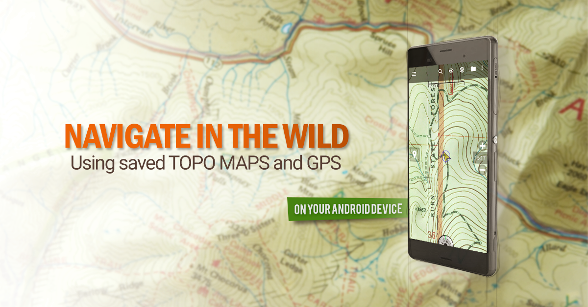
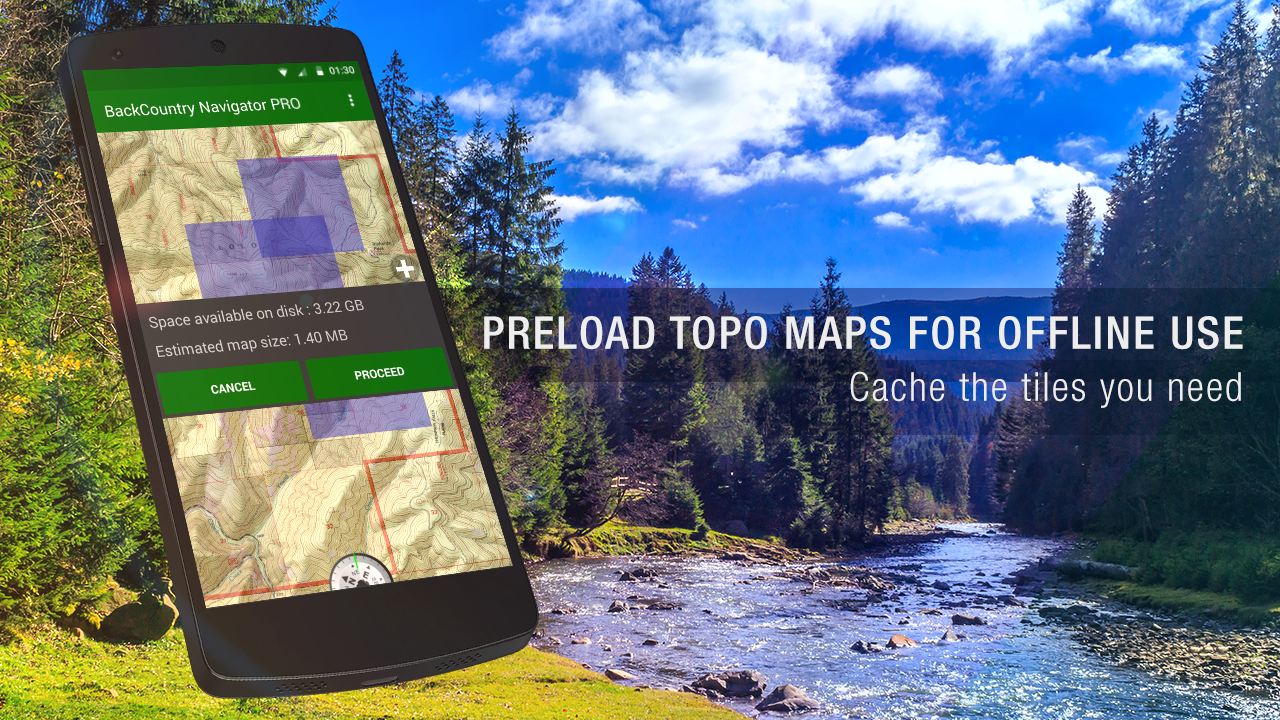
Download topo maps for an offline outdoornavigator! Use your phone or tablet as an offroad topo mappinghandheld GPS with the bestselling outdoor navigation app forAndroid! Explore beyond cell coverage for hiking and otherrecreation.
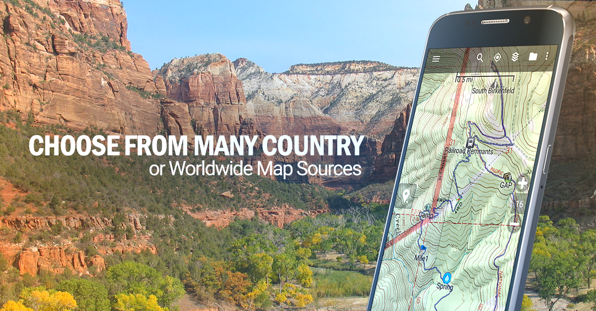
Download topo maps for the US and many other countries in advance,so you won't need cell coverage for navigation. Use storage memoryfor maps.
New: Android Wear support to see navigation at a glance onwrist
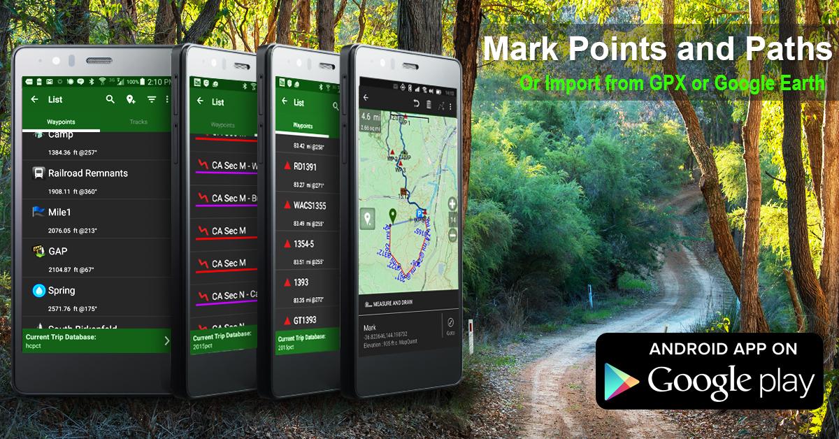
Use GPS waypoints from GPX or KML files, or enter your owncoordinates using longitude/latitude, UTM, MGRS, or grid reference.Using GOTO makes a waypoint a locus for navigation.
This uses many publicly available map sources as free downloads.Some additional content available as an in app purchase:
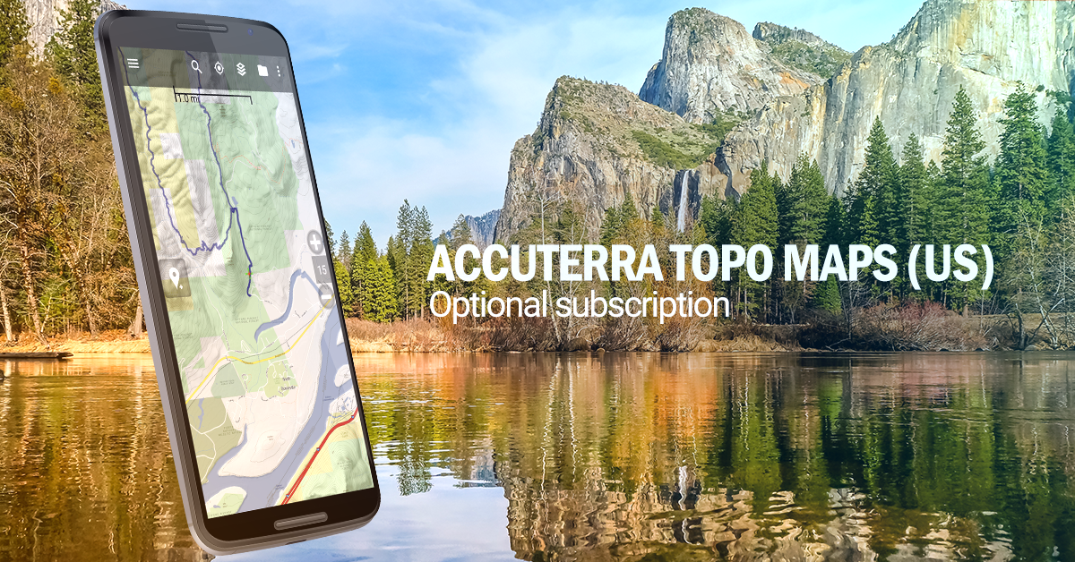
-Accuterra Topo Map Source for $19.99/year. This can be purchasedand used with or in instead of the free sources.
- Boundary maps for 12 western states from the Bureau of LandManagement(BLM) Overlay for topo maps valued by hunters.
-GMU boundaries in some states
-Lake Contours in several states.
-Content from US TrailMaps including:
-ATV, Whitewater, and Equestrian Trail Maps
See the menu under More-> "Purchasing AddOns". They can be shownon top of topo maps.
You may try the DEMO version to make sure you like the maps in yourcountry.
About topo (topographic) maps: Topo maps show terrain through colorand contours, and are useful for navigation offroad. Topo maps andGPS can be used for hiking, hunting, kayaking, snowshoeing, &backpacker trails.
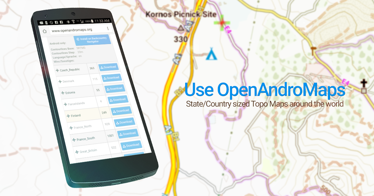
You can create your own maps with Mobile Atlas Creator, or specifya custom tile server. Built in sources include:
OpenStreetMaps from MapQuest
OpenCycleMaps showing terrain worldwide
US Topo Maps from Caltopo and the USGS
USTopo: Aerial Photography with markup.
Canada Topo Maps from Toporama
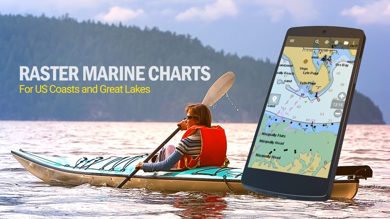
Marine maps: NOAA RNC Nautical Charts (coastal)
USGS Color Aerial photography
Topographic Maps of Spain and Italy
Topo maps of New Zealand
Japan GSI maps.
Many of the above sources are generally free to use.
Use offline topo maps and GPS on hiking trails without cellservice. The GPS in your Android phone can get its position fromGPS satellites, and you don’t have to rely on your data plan to getmaps. Have more fun and safe GPS navigation in thebackcountry.
Use as a geocaching navigator by getting a pocket query asGPX.
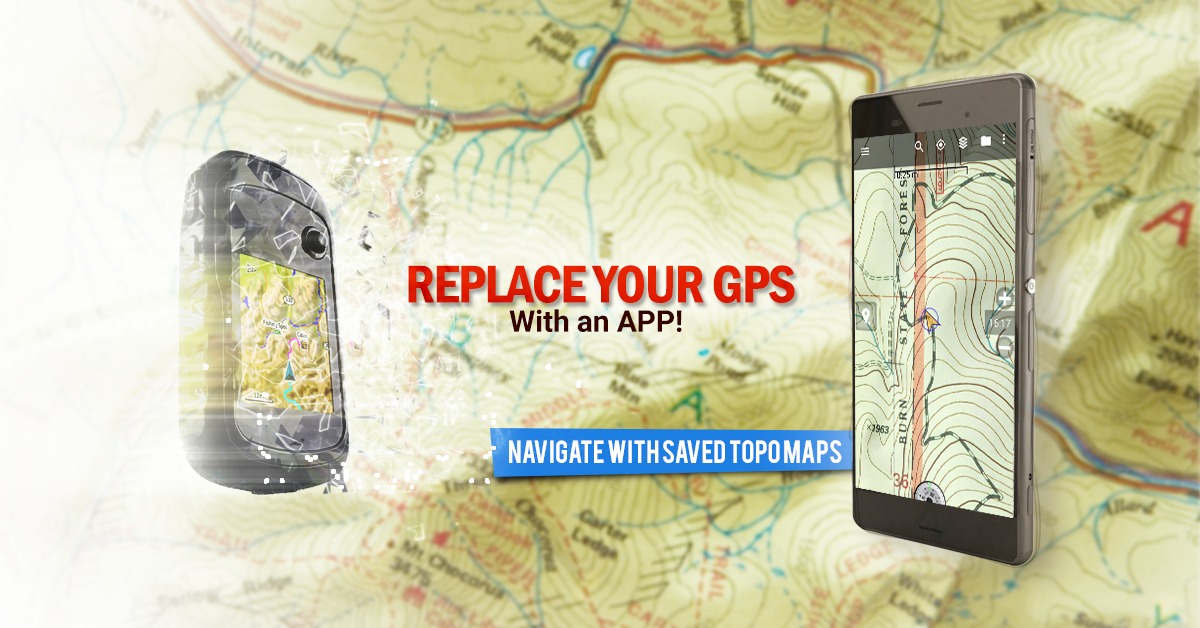
Besides geocaching, use GPS for recording tracks and GPS waypointson your trip, all the while tracking your GPS quest on topographicmaps. It may replace your Garmin handheld GPS.
Here are some of the outdoor GPS activities BackCountry Navigatorhas been used for:
As a hiking GPS both on hiking trails and off trail.
Camping trips to find that perfect camping site or the way back tocamp with GPS.
Hunting trips for hunting wild game in rugged areas.
Doing recon for a hunt or as your hunting GPS
Fishing: make it your fishing GPS.
Search and Rescue (SAR).
Trekking the Pacific Crest trail or other long term hiking.
Kayak and canoe treks on inland lakes and streams or marine,coastal waters.
Backpacker trips: using topo maps of wilderness areas and nationalforests for navigation on trails with the GPS in your rucksack orbackpack.
Find your own ways to have fun in the outdoors. Be a maverick byventuring beyond cell service boundaries with your GPS. Become apro at navigation with GPS for the outdoors.
BackCountry Navigator has been on WM devices and preloaded on theTrimble Nomad outdoor rugged device. This Android version is moreflexible, featured, and fun. Create a memory with maps.
For a one time fee, this a great addition to the outdoor gear youbought at Cabelas, REI, or another outdoor store. Many have foundthe Android GPS in a phone or tablet to substitute for a Garmin GPSor Magellan GPS, such as the Garmin GPS units Montana, Etrex, orOregon. Android can be your handheld GPS.
Download topo maps for the US and many other countries in advance,so you won't need cell coverage for navigation. Use storage memoryfor maps.
New: Android Wear support to see navigation at a glance onwrist
Use GPS waypoints from GPX or KML files, or enter your owncoordinates using longitude/latitude, UTM, MGRS, or grid reference.Using GOTO makes a waypoint a locus for navigation.
This uses many publicly available map sources as free downloads.Some additional content available as an in app purchase:
-Accuterra Topo Map Source for $19.99/year. This can be purchasedand used with or in instead of the free sources.
- Boundary maps for 12 western states from the Bureau of LandManagement(BLM) Overlay for topo maps valued by hunters.
-GMU boundaries in some states
-Lake Contours in several states.
-Content from US TrailMaps including:
-ATV, Whitewater, and Equestrian Trail Maps
See the menu under More-> "Purchasing AddOns". They can be shownon top of topo maps.
You may try the DEMO version to make sure you like the maps in yourcountry.
About topo (topographic) maps: Topo maps show terrain through colorand contours, and are useful for navigation offroad. Topo maps andGPS can be used for hiking, hunting, kayaking, snowshoeing, &backpacker trails.
You can create your own maps with Mobile Atlas Creator, or specifya custom tile server. Built in sources include:
OpenStreetMaps from MapQuest
OpenCycleMaps showing terrain worldwide
US Topo Maps from Caltopo and the USGS
USTopo: Aerial Photography with markup.
Canada Topo Maps from Toporama
Marine maps: NOAA RNC Nautical Charts (coastal)
USGS Color Aerial photography
Topographic Maps of Spain and Italy
Topo maps of New Zealand
Japan GSI maps.
Many of the above sources are generally free to use.
Use offline topo maps and GPS on hiking trails without cellservice. The GPS in your Android phone can get its position fromGPS satellites, and you don’t have to rely on your data plan to getmaps. Have more fun and safe GPS navigation in thebackcountry.
Use as a geocaching navigator by getting a pocket query asGPX.
Besides geocaching, use GPS for recording tracks and GPS waypointson your trip, all the while tracking your GPS quest on topographicmaps. It may replace your Garmin handheld GPS.
Here are some of the outdoor GPS activities BackCountry Navigatorhas been used for:
As a hiking GPS both on hiking trails and off trail.
Camping trips to find that perfect camping site or the way back tocamp with GPS.
Hunting trips for hunting wild game in rugged areas.
Doing recon for a hunt or as your hunting GPS
Fishing: make it your fishing GPS.
Search and Rescue (SAR).
Trekking the Pacific Crest trail or other long term hiking.
Kayak and canoe treks on inland lakes and streams or marine,coastal waters.
Backpacker trips: using topo maps of wilderness areas and nationalforests for navigation on trails with the GPS in your rucksack orbackpack.
Find your own ways to have fun in the outdoors. Be a maverick byventuring beyond cell service boundaries with your GPS. Become apro at navigation with GPS for the outdoors.
BackCountry Navigator has been on WM devices and preloaded on theTrimble Nomad outdoor rugged device. This Android version is moreflexible, featured, and fun. Create a memory with maps.
For a one time fee, this a great addition to the outdoor gear youbought at Cabelas, REI, or another outdoor store. Many have foundthe Android GPS in a phone or tablet to substitute for a Garmin GPSor Magellan GPS, such as the Garmin GPS units Montana, Etrex, orOregon. Android can be your handheld GPS.