hourglass_full Your download should start automatically in a few seconds...

Download Gps Natura_Latest Version.apk from Apk-Dl Server
Thank you for using Apk-Dl.com to download the apk file (Gps Natura_Latest Version.apk),
If the download doesn't start automatically in a few seconds, please click here to access the download URL directly.
Note: Download and save the apk file to your Android Phone's SD card and install it manually onto the Android device.


Description
Non solo Gps per l'App "Gps Natura" propostada UBN - Unione Bolognese Naturalisti http://www.naturalisti-ubn.it - a tutti gliamanti della natura al fine di registrare, segnalare e conoscereaspetti rilevanti del territorio che li circonda e anchetracciare propri percorsi, registrarli e ottenerne unastatistica.
Funzioni
• Possibilità di muovere l'App su scheda SD
• Localizzazione veloce
• Geolocalizzazione con Gps
• Scelta dell'accuratezza del Gps
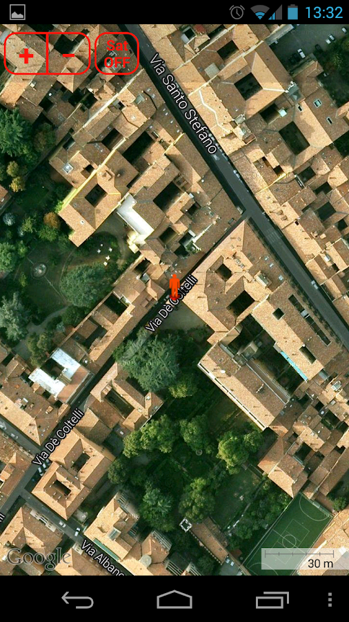
• Geolocalizzazione da mappa
• Localizzazione immettendo le coordinate geografiche
• Visualizzazione della località corrispondente allecoordinate
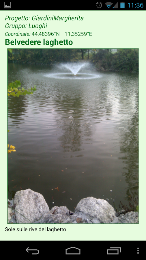
• Aggiunta di foto alla geolocalizzazione
• Memorizzazione delle coordinate insieme a descrizione efoto
• Schede raggruppate in un archivio per progetti e gruppi
• Numerose icone disponibili, come albero, giardino, fungo,farfalla, insetto,fossile, minerale e altre
• Segnalazione delle coordinate con email, allegando foto emappa
• Gestione dell'archivio con miglioramento delle coordinate tramitemappa
• Spostamento dell'archivio su scheda SD
• Ricerca e visualizzazione delle schede con descrizione efoto
• Visualizzazione delle schede da elenco o mappa con icone e codicecolori
• Progetti completi esportabili come file e allegabili aun'Email
• Progetti completi importabili da parte di altri smartphone oreimportabili per funzionalità di backup/restore
• Tracciamento di percorsi con Gps
• Statistiche sui percorsi effettuati
• Raccolta di dati sui percorsi: distanza, tempo di cammino, tempodi sosta, velocità, coordinate di partenza e di arrivo
• Possibilità di aggiungere in un tempo successivo un titolo e unadescrizione ai percorsi
• Opzione per rilevare automaticamente le soste durante i percorsi,basandosi sulla posizione o sul movimento
• Mappa opzionale dei singoli percorsi archiviabile insieme aglialtri dati
• Bussola con bolla, inclinazione frontale e laterale, esposizioneai venti
• Scelta del tipo di bussola
• Soleggiamento con alba, tramonto, ore di luce e percorsoapparente del sole
• Importazione ed esportazione di archivi (previo accordo congestore)
• Guida all'uso dell'applicazione con esempi di utilizzo
Possibili usi
• Botanica, micologia, entomologia, paleontologia, geologia
• Studio di alberi, arbusti ed erbe
• Progetto di giardini
• Ricerca di funghi
• Diario di pesca
• Diario di viaggio
• Diario dei percorsi o delle camminate
Caratteristiche
La localizzazione, oltre che con il Gps, può essereeffettuata per mezzo della mappa o immettendo manualmente lecoordinate.
Dopo aver individuato una posizione è possibile creare unascheda e anche comunicare quanto riscontrato, corredandoil tutto con la mappa e una foto.
Le schede create possono essere cancellate o modificate e lecoordinate possono essere definite con maggiore precisione.
Tutte le schede vengono strutturate in un progettocostituito da gruppi omogenei e possono essere elencate omostrate su una mappa che ne rende possibile la navigazione.
Attualmente si possono importare - a titolo di esempio - dueprogetti già costruiti, così come è possibile, in accordo con chigestisce l'applicazione, esportare propri progetti.
Lo scopo è quello di creare mappe di navigazione condivise,permettendone il caricamento a tutti gli interessati a specifichetematiche naturalistiche.
Completano l'App una bussola e i dati sul soleggiamento perogni luogo e ogni giorno dell'anno.
Oltre alla valutazione e alla recensione è gradita unasegnalazione dettagliata degli eventuali problemi inviandoun'email all'autore, in modo da poter giungere ad una loro rapidasoluzione.
Funzioni
• Possibilità di muovere l'App su scheda SD
• Localizzazione veloce
• Geolocalizzazione con Gps
• Scelta dell'accuratezza del Gps
• Geolocalizzazione da mappa
• Localizzazione immettendo le coordinate geografiche
• Visualizzazione della località corrispondente allecoordinate
• Aggiunta di foto alla geolocalizzazione
• Memorizzazione delle coordinate insieme a descrizione efoto
• Schede raggruppate in un archivio per progetti e gruppi
• Numerose icone disponibili, come albero, giardino, fungo,farfalla, insetto,fossile, minerale e altre
• Segnalazione delle coordinate con email, allegando foto emappa
• Gestione dell'archivio con miglioramento delle coordinate tramitemappa
• Spostamento dell'archivio su scheda SD
• Ricerca e visualizzazione delle schede con descrizione efoto
• Visualizzazione delle schede da elenco o mappa con icone e codicecolori
• Progetti completi esportabili come file e allegabili aun'Email
• Progetti completi importabili da parte di altri smartphone oreimportabili per funzionalità di backup/restore
• Tracciamento di percorsi con Gps
• Statistiche sui percorsi effettuati
• Raccolta di dati sui percorsi: distanza, tempo di cammino, tempodi sosta, velocità, coordinate di partenza e di arrivo
• Possibilità di aggiungere in un tempo successivo un titolo e unadescrizione ai percorsi
• Opzione per rilevare automaticamente le soste durante i percorsi,basandosi sulla posizione o sul movimento
• Mappa opzionale dei singoli percorsi archiviabile insieme aglialtri dati
• Bussola con bolla, inclinazione frontale e laterale, esposizioneai venti
• Scelta del tipo di bussola
• Soleggiamento con alba, tramonto, ore di luce e percorsoapparente del sole
• Importazione ed esportazione di archivi (previo accordo congestore)
• Guida all'uso dell'applicazione con esempi di utilizzo
Possibili usi
• Botanica, micologia, entomologia, paleontologia, geologia
• Studio di alberi, arbusti ed erbe
• Progetto di giardini
• Ricerca di funghi
• Diario di pesca
• Diario di viaggio
• Diario dei percorsi o delle camminate
Caratteristiche
La localizzazione, oltre che con il Gps, può essereeffettuata per mezzo della mappa o immettendo manualmente lecoordinate.
Dopo aver individuato una posizione è possibile creare unascheda e anche comunicare quanto riscontrato, corredandoil tutto con la mappa e una foto.
Le schede create possono essere cancellate o modificate e lecoordinate possono essere definite con maggiore precisione.
Tutte le schede vengono strutturate in un progettocostituito da gruppi omogenei e possono essere elencate omostrate su una mappa che ne rende possibile la navigazione.
Attualmente si possono importare - a titolo di esempio - dueprogetti già costruiti, così come è possibile, in accordo con chigestisce l'applicazione, esportare propri progetti.
Lo scopo è quello di creare mappe di navigazione condivise,permettendone il caricamento a tutti gli interessati a specifichetematiche naturalistiche.
Completano l'App una bussola e i dati sul soleggiamento perogni luogo e ogni giorno dell'anno.
Oltre alla valutazione e alla recensione è gradita unasegnalazione dettagliata degli eventuali problemi inviandoun'email all'autore, in modo da poter giungere ad una loro rapidasoluzione.
Not only for the GPS App"Gps Nature" proposed by UBN - Bolognese Naturalists Union http://www.naturalisti-ubn.it - to all loversof nature in order to record, report andlearn about relevant aspects of the territory that surrounds themand also trace their routes, register themand obtain a statistic .
Functions
• Ability to move the app to SD card
• Location fast
• Geolocation with GPS
• Choice of the accuracy of GPS
• Geolocation by map
• Locating by entering the geographical coordinates
• Displaying the location corresponding to the coordinates
• Adding photos to geolocation
• Storing the coordinates along with a description andpictures
• Data grouped in an archive for projects and groups
• Many icons available, such as tree, garden, mushroom, butterfly,insect, fossil, mineral and other
• Reporting of coordinates with email, attaching photos andmap
• Management of the improvement with the coordinates via themap
• to Move to SD card
• Search and display boards and book
• Display boards from a list or map with icons and color code
• Complete projects can be exported as a file and can attach to anEmail
• Complete projects can be imported from other smartphone orreimportabili functionality for backup / restore
• Tracking of routes with GPS
• Statistics on the journeys made
• Collection of data on paths: distance, walking time, dwell time,speed, coordinates of departure and arrival
• Ability to add at a later time a title and description to thepaths
• Option to automatically detect the stops along the route, basedon location or on the move
• Map of the individual optional paths that can be stored alongwith other data
• Compass with bubble, tilt front and side, exposed to thewinds
• Choosing the type of compass
• Sunshine with sunrise, sunset, daylight hours and the apparentpath of the sun
• Import and export of files (by prior arrangement with theoperator)
• Guide application with usage samples
Possible uses
• Botany, mycology, entomology, paleontology, geology
• Study of trees, shrubs and herbs
• Draft gardens
• Searching for fungi
• Diary of fishing
• Travelogue
• Diary of paths or walks
Features
The location , as well as with the Gps , can be carried out bymeans of map or by manually entering the coordinates.
After you find a location you can create a card and alsocommunicate As reported, adding to it all with a map and aphoto.
The cards you create can be deleted or modified and the coordinatescan be defined with greater precision.
All the cards are laid out in a project consists of Groupshomogeneous and may be listed or shown on a map that makes itpossible to navigate.
Currently you can import - for example - two projects alreadybuilt, as it is possible, in agreement with those running theapplication, export your projects.
The aim is to create navigation maps shared, allowing the load toall interested parties on specific issues naturalistic.
Completing the App a compass and data on sunshine for everyplace and every day of the year.
In addition to the evaluation and review is a welcome detailedreporting any problems by sending an email to the author, in orderto achieve their rapidsolution.