hourglass_full Your download should start automatically in a few seconds...

Download Rutas GPX La Palma_Latest Version.apk from Apk-Dl Server
Thank you for using Apk-Dl.com to download the apk file (Rutas GPX La Palma_Latest Version.apk),
If the download doesn't start automatically in a few seconds, please click here to access the download URL directly.
Note: Download and save the apk file to your Android Phone's SD card and install it manually onto the Android device.


Description
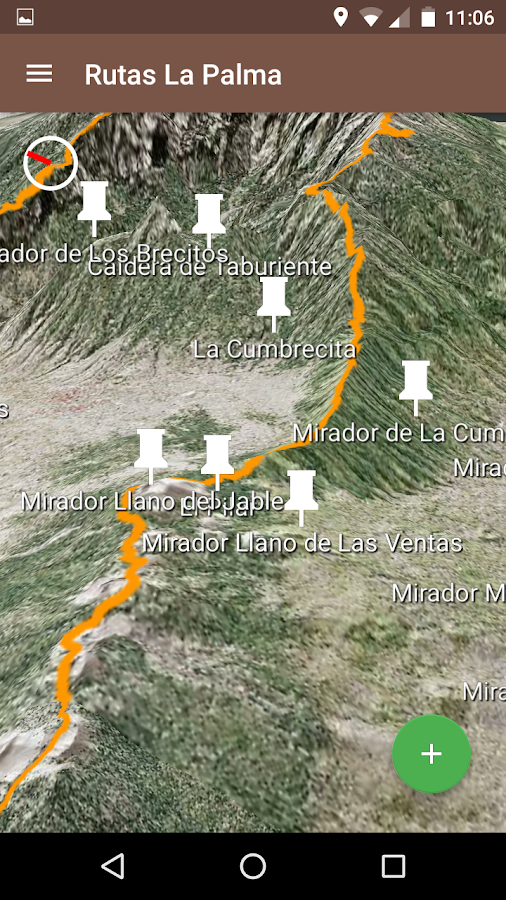
Esta app permite representar en un mapa en 3Dy 2D las rutas ya almacenadas previamente para la isla de La Palmaasí como acceder a toda la información también incluida referente alas propias rutas y sus puntos de interés.
Al visualizar las rutas en los mapas, la app ofrece múltiplesopciones y posibilidades de qué y cómo visualizar los elementos enel mapa de forma que el usuario pueda para sacar el máximo provechoa dichas rutas, ofreciendo información de todo tipo que puedeactivarse o desactivarse para que sea mostrada o no en elmapa.
Además se incluye información de interés de índole diversoreferente a La Palma como la ubicación y descripción de lugares yedificaciones destacados de la isla. También se incluye informacióncompleta de la Transvulcania como pueden ser aspectos destacablesde la carrera en sí e información detallada sobre los tramos queincluye la misma.
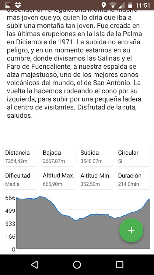
Otra de las posibilidades que ofrece esta app es la de realizartracking de rutas de la isla ya sean nuevas completamente o seguiralguna de las ya existentes. En este último caso, la app ofrecetoda clase de información sobre la ruta a seguir con la finalidadde facilitar al caminante realizar el recorrido perfectamente ydisfrutar de todas las posibilidades que este le ofrece. Durante eltracking, el usuario podrá añadir puntos de interés al recorrido.Estos puntos de interés podrán añadirse utilizando fotos coninformación de geolocalización o utilizando la posición actualobtenida por el GPS.
Finalmente, la app también permite la importación y exportación derutas a través del uso de ficheros en formato GPX (utilizado porejemplo por Wikiloc). Para importar una ruta, el usuario podráincorporarla a su app abriendo dicho fichero con la opción dehacerlo usando esta app concretamente. Así, las rutas importadasserán incorporarlas a la app como nuevas rutas editables donde elusuario puede modificar o eliminar cualquiera de los punto deinterés existentes o añadir nuevos. Estos nuevos puntos de interéspodrán añadirse utilizando fotos con información de geolocalizacióno utilizando la posición actual obtenida por el GPS. Además, tantoel título como el contenido de la ruta en si y de sus puntos deinterés puede ser modificado utilizando el modo edición. Para lasfotos asociadas a la ruta en si y a sus puntos de interés, elusuario podrá añadir nuevas fotos en cualquier momento.
Todas las rutas editables incorporadas a la app (ya sea medianteimportación de alguna ya existente o por generación mediantetracking) pueden ser compartidas vía redes sociales, mensaje ocorreo electrónico como un fichero en formato GPX de forma que elusuario receptor de dicha ruta podrá incorporarla a su app abriendodicho fichero con la opción de hacerlo usando esta appconcretamente.
Resaltar que la funcionalidad de esta app se encuentra circunscritaa la isla de La Palma y cualquier ruta que no se encuentregeolocalizada dentro del ámbito de la misma no será mostrada por laapp.
Al visualizar las rutas en los mapas, la app ofrece múltiplesopciones y posibilidades de qué y cómo visualizar los elementos enel mapa de forma que el usuario pueda para sacar el máximo provechoa dichas rutas, ofreciendo información de todo tipo que puedeactivarse o desactivarse para que sea mostrada o no en elmapa.
Además se incluye información de interés de índole diversoreferente a La Palma como la ubicación y descripción de lugares yedificaciones destacados de la isla. También se incluye informacióncompleta de la Transvulcania como pueden ser aspectos destacablesde la carrera en sí e información detallada sobre los tramos queincluye la misma.
Otra de las posibilidades que ofrece esta app es la de realizartracking de rutas de la isla ya sean nuevas completamente o seguiralguna de las ya existentes. En este último caso, la app ofrecetoda clase de información sobre la ruta a seguir con la finalidadde facilitar al caminante realizar el recorrido perfectamente ydisfrutar de todas las posibilidades que este le ofrece. Durante eltracking, el usuario podrá añadir puntos de interés al recorrido.Estos puntos de interés podrán añadirse utilizando fotos coninformación de geolocalización o utilizando la posición actualobtenida por el GPS.
Finalmente, la app también permite la importación y exportación derutas a través del uso de ficheros en formato GPX (utilizado porejemplo por Wikiloc). Para importar una ruta, el usuario podráincorporarla a su app abriendo dicho fichero con la opción dehacerlo usando esta app concretamente. Así, las rutas importadasserán incorporarlas a la app como nuevas rutas editables donde elusuario puede modificar o eliminar cualquiera de los punto deinterés existentes o añadir nuevos. Estos nuevos puntos de interéspodrán añadirse utilizando fotos con información de geolocalizacióno utilizando la posición actual obtenida por el GPS. Además, tantoel título como el contenido de la ruta en si y de sus puntos deinterés puede ser modificado utilizando el modo edición. Para lasfotos asociadas a la ruta en si y a sus puntos de interés, elusuario podrá añadir nuevas fotos en cualquier momento.
Todas las rutas editables incorporadas a la app (ya sea medianteimportación de alguna ya existente o por generación mediantetracking) pueden ser compartidas vía redes sociales, mensaje ocorreo electrónico como un fichero en formato GPX de forma que elusuario receptor de dicha ruta podrá incorporarla a su app abriendodicho fichero con la opción de hacerlo usando esta appconcretamente.
Resaltar que la funcionalidad de esta app se encuentra circunscritaa la isla de La Palma y cualquier ruta que no se encuentregeolocalizada dentro del ámbito de la misma no será mostrada por laapp.
This app can represent a2D and 3D map routes and previously stored for the island of LaPalma as well as access to all information also included concerningthe own routes and points of interest.
When viewing routes on maps, the app offers multiple options andpossibilities of what and how to display the items on the map sothat the user can to make the most of these routes, offering allkinds of information that can be activated or deactivated to beshown or not on the map.
In addition relevant information of various kinds concerning LaPalma as the location and description of places and prominentbuildings on the island it is included. Full informationTransvulcania also included as can be highlights of the race itselfand detailed information about the sections that includes it.
Another possibility offered by this app is to make tracking routesof the island either completely new or follow any of the existingones. In the latter case, the app offers all kinds of informationabout the route to follow in order to facilitate the walker makethe route perfectly and enjoy all the possibilities this offers.During tracking, the user can add points of interest to travel.These points of interest can be added using photos or geolocationinformation using the current position obtained by the GPS.
Finally, the app also allows import and export routes through theuse of files in GPX format (used for example Wikiloc). To import aroute, the user can incorporate your app by opening the file withthe option to do so using this app specifically. Thus, importedroutes will incorporate them into the app as new editable pathswhere the user can modify or delete any of the existing point ofinterest or add new ones. These new points of interest can be addedusing photos or geolocation information using the current positionobtained by the GPS. In addition, both the title and the content ofthe route itself and its points of interest can be modified usingthe edit mode. For photos associated with the route itself and itspoints of interest, the user can add new photos at any time.
All editable paths built into the app (either by importing anyexisting or generation through tracking) can be shared via socialnetworks, message or email as a file in GPX format so that thereceiving user of this route may incorporate it into your app byopening the file with the option to do so using this appspecifically.
Highlight the functionality of this app is restricted to the islandof La Palma and any route that is not within the scope of the samegeographic location will not be displayed by the app.