hourglass_full Your download should start automatically in a few seconds...

Download 路況快易通_Latest Version.apk from Apk-Dl Server
Thank you for using Apk-Dl.com to download the apk file (路況快易通_Latest Version.apk),
If the download doesn't start automatically in a few seconds, please click here to access the download URL directly.
Note: Download and save the apk file to your Android Phone's SD card and install it manually onto the Android device.
Description
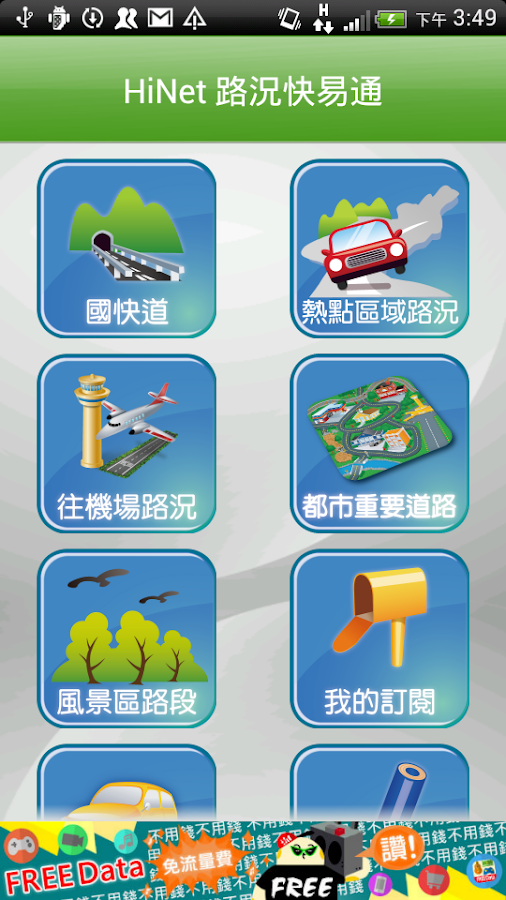
七大功能
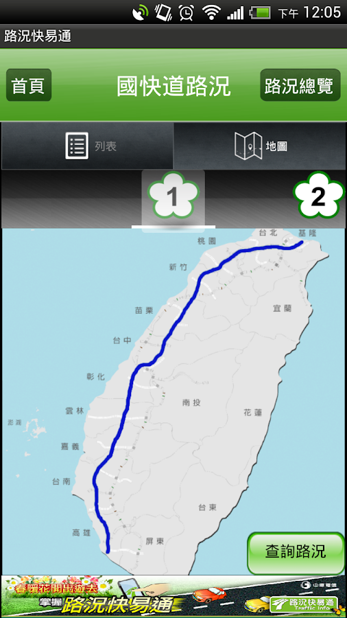
1. 國快道路況
(1)快速查詢路況
-提供完整官方國快道路況資訊
-提供列表模式與地圖模式,快速找尋欲行駛路線的路況
(2)路況比較
-走國一好還是國三好呢? 路況比較功能,讓您一目了然國快道上哪一段正堵車,上路前就贏在起跑點!
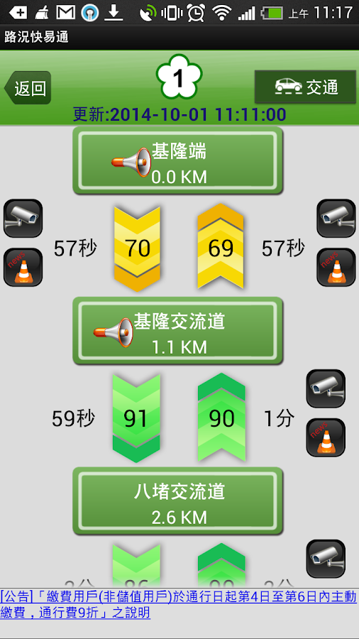
(3)詳細路況
-提供每一條國快道內詳細的時速、旅行時間、即時車流影像、即時事件等交通資訊
-內含即時回報功能,讓您掌握第一手路況資訊。
-即時車流影像可分享至Facebook,告訴親朋好友所在地最新路況
(4)簡易模式
-眼見為憑,直接提供即時靜態車流影像給您,塞不塞車一眼可知!
(5)即時重大訊息
-提供您國快道即時封路或高乘載管制等資訊
(6)替代道路資訊
-前方路況壅塞時,提供國道替代道路即時時速與車流影像資訊,讓您決定是否要改走替代道路節省行車時間
2.熱點區域路況
(1)使用情境
-現在從宜蘭回台北走國道大概要多久呢?
-如果改走XX路會不會比較快呢?
-上交流道的排隊等候時間大約多久呢?
(2)簡圖功能
-以簡圖方式呈現易壅塞區域之主要路段與替代道路之旅行時間,方便用路人做改道決策,同時提供上交流道之排隊等候時間以避免因交管措施導致旅行時間無法反映真實狀況。
3. 機場路線
(1) 4條南下北上往機場的國快道路徑
(2) 提供往機場路徑上的時速、旅行時間、即時車流影像、事件等資訊。
(3) 抵達機場後,華航旅客可一鍵無縫轉移至華航票務APP。
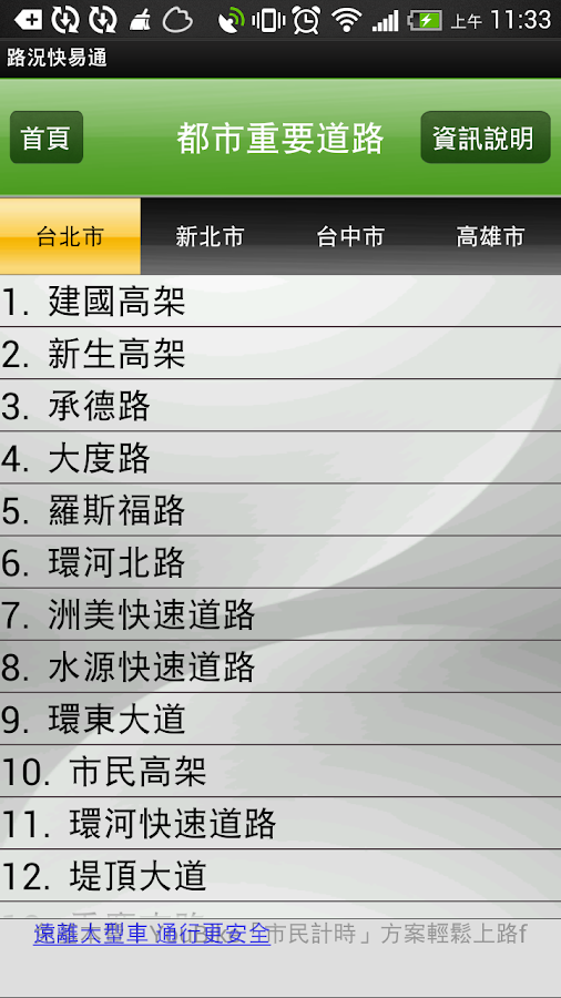
4. 都市重要道路
(1)使用情境
-初來貴寶地,大都市裡我要走的這幾條路會不會塞車呢?
(2)都市重要道路
-目前提供台北市、新北市、台中市與高雄市重要道路的即時交通資訊,包括時速、即時車流影像、事件等
-除了各地方政府交通局的資訊外,中華電信獨家提供更多路段的即時時速資料
-提供各都市交通局重大交管措施資訊,讓您即早繞道不走冤枉路!
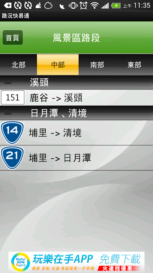
5. 風景區路段
(1) 提供前往熱門風景區的CCTV影像資訊
(2) 目前提供北部三芝至野柳;中部埔里至日月潭、埔里至清境;南部嘉義至阿里山、墾丁楓港至鵝鑾鼻;東部花蓮至蘇澳。
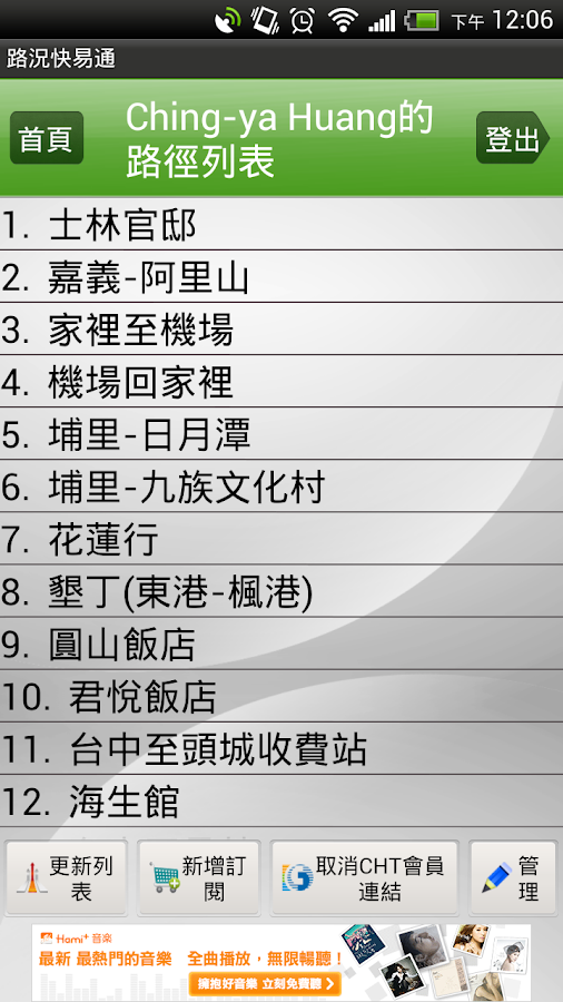
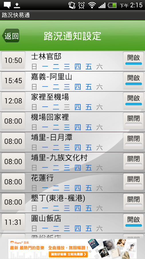
6. 我的訂閱
(1)使用情境
-今天上班平常走的那條路會不會有狀況呢?
-這時間走XX路會不會塞車呢?
(2)我的訂閱功能
-利用網站或手機端路徑訂閱功能,自訂常用路徑。
-每條路徑皆可設定通知時間,上路前路況快易通即主動通知目前路況,讓您即時決定是否改道
7. 道路救援資訊
根據所在位置提供國道道路救援電話
1. 國快道路況
(1)快速查詢路況
-提供完整官方國快道路況資訊
-提供列表模式與地圖模式,快速找尋欲行駛路線的路況
(2)路況比較
-走國一好還是國三好呢? 路況比較功能,讓您一目了然國快道上哪一段正堵車,上路前就贏在起跑點!
(3)詳細路況
-提供每一條國快道內詳細的時速、旅行時間、即時車流影像、即時事件等交通資訊
-內含即時回報功能,讓您掌握第一手路況資訊。
-即時車流影像可分享至Facebook,告訴親朋好友所在地最新路況
(4)簡易模式
-眼見為憑,直接提供即時靜態車流影像給您,塞不塞車一眼可知!
(5)即時重大訊息
-提供您國快道即時封路或高乘載管制等資訊
(6)替代道路資訊
-前方路況壅塞時,提供國道替代道路即時時速與車流影像資訊,讓您決定是否要改走替代道路節省行車時間
2.熱點區域路況
(1)使用情境
-現在從宜蘭回台北走國道大概要多久呢?
-如果改走XX路會不會比較快呢?
-上交流道的排隊等候時間大約多久呢?
(2)簡圖功能
-以簡圖方式呈現易壅塞區域之主要路段與替代道路之旅行時間,方便用路人做改道決策,同時提供上交流道之排隊等候時間以避免因交管措施導致旅行時間無法反映真實狀況。
3. 機場路線
(1) 4條南下北上往機場的國快道路徑
(2) 提供往機場路徑上的時速、旅行時間、即時車流影像、事件等資訊。
(3) 抵達機場後,華航旅客可一鍵無縫轉移至華航票務APP。
4. 都市重要道路
(1)使用情境
-初來貴寶地,大都市裡我要走的這幾條路會不會塞車呢?
(2)都市重要道路
-目前提供台北市、新北市、台中市與高雄市重要道路的即時交通資訊,包括時速、即時車流影像、事件等
-除了各地方政府交通局的資訊外,中華電信獨家提供更多路段的即時時速資料
-提供各都市交通局重大交管措施資訊,讓您即早繞道不走冤枉路!
5. 風景區路段
(1) 提供前往熱門風景區的CCTV影像資訊
(2) 目前提供北部三芝至野柳;中部埔里至日月潭、埔里至清境;南部嘉義至阿里山、墾丁楓港至鵝鑾鼻;東部花蓮至蘇澳。
6. 我的訂閱
(1)使用情境
-今天上班平常走的那條路會不會有狀況呢?
-這時間走XX路會不會塞車呢?
(2)我的訂閱功能
-利用網站或手機端路徑訂閱功能,自訂常用路徑。
-每條路徑皆可設定通知時間,上路前路況快易通即主動通知目前路況,讓您即時決定是否改道
7. 道路救援資訊
根據所在位置提供國道道路救援電話
Seven function
1. The National Road Traffic Fast
(1) Quick Search Traffic
- Provides complete official national roadtraffic information fast
- Provides a list mode and map mode, quickly wantto find the travel route of the road
(2) Comparison of road
- Take the country, one country, three good orrelatively good road conditions, allowing you to quickly glancecountry lane which some positive traffic jam, before the road winat the starting point?!
(3) Detailed road
- Provide every detail of a national fast-trackspeed, travel time, instant traffic video, and other real-timetraffic information event
- Includes immediate return feature that allowsyou to gain first-hand traffic information.
- Real-time traffic images can be shared toFacebook, tell friends and family the location of trafficupdates
(4) Easy mode
- Seeing is believing, provide instant trafficstill images directly to you see at a glance the plug withouttraffic jams!
(5) major instant messaging
- Provide you with immediate fast-track countryroad closures or other information HOV
(6) an alternative road information
- When the road ahead congestion, providealternative national highway road speed and real-time traffic videoinformation, allowing you to decide whether you want to change togo an alternative way to save travel time
2. Traffic hotspots
(1) the use of scenarios
- Now go back to Taipei from Yilan NationalHighway probably how long?
- If you change the road will go XX relativelyfast?
- On the ramp waiting in line for about howlong?
(2) Function diagram
- A schematic way of presenting the main road andeasy alternative to the congestion area and the road travel time,easy to do with passers diversion decisions, while providing lineup the ramp of the waiting time in order to avoid the trafficcontrol measures have led to the travel time does not reflect thereal situation.
3. Airport Route
(1) 4 south to the north of the country to the airport fast-trackpath
(2) to provide a path to the airport per hour, travel time,real-time traffic video, events and other information.
(3) Upon arrival at the airport, China Airlines passengers can be akey to a seamless transfer CAL ticket APP.
4. urban major roads
(1) the use of scenarios
- First came to your treasure, big city I gothese routes will not jam it?
(2) major roads in the city
- Currently available in Taipei, the new Taipeireal-time traffic information, Taichung and Kaohsiung major roads,including speed, real-time traffic video, events, etc.
- In addition to the local government'sDepartment of Transportation information, the exclusive ChunghwaTelecom to provide more real-time speed data link
- Provide each major city Department ofTransportation traffic control measures information, so you do nottake the long route of immediate early detour!
5. scenic road
(1) provide to the popular scenic CCTV image information
(2) is currently available in northern Sanjhih to Yehliu; CentralPuli to Sun Moon Lake, Puli to Cingjing; southern Chiayi toAlishan, Kenting Fenggang to Eluanbi; eastern Hualien toSuao.
6. My Subscriptions
(1) the use of scenarios
- Work today to go that way usually will not havea situation?
- This time will not go XX road traffic jamit?
(2) My Subscriptions
- The use of the website or mobile phonesubscriptions end of the trail, a custom common path.
- Inform each path are able to set the time onthe road before the traffic that is proactive notification Autotollcurrent traffic conditions, allowing you to instantly decidewhether diversions
7. Roadside Assistance Information
Provide relief road National Highway phone according tolocation