hourglass_full Your download should start automatically in a few seconds...

Download MitoApp_Latest Version.apk from Apk-Dl Server
Thank you for using Apk-Dl.com to download the apk file (MitoApp_Latest Version.apk),
If the download doesn't start automatically in a few seconds, please click here to access the download URL directly.
Note: Download and save the apk file to your Android Phone's SD card and install it manually onto the Android device.

Description
Grazie ai finanziamenti del Progetto MITO, ISPRA e 7Universitàdel Mezzogiorno, tra cui UniPA, hanno saputo realizzarela primapiattaforma per la gestione e scambio di oggettigeo-riferiti, aservizio e integrazione di attività di vari settori,che spazianodalla valorizzazione del patrimonio culturale, allatutelaambientale, alla pianificazione territoriale, con unaparticolareenfasi dedicata agli strumenti di acquisizione etrasmissione didati e informazioni in mobilità.
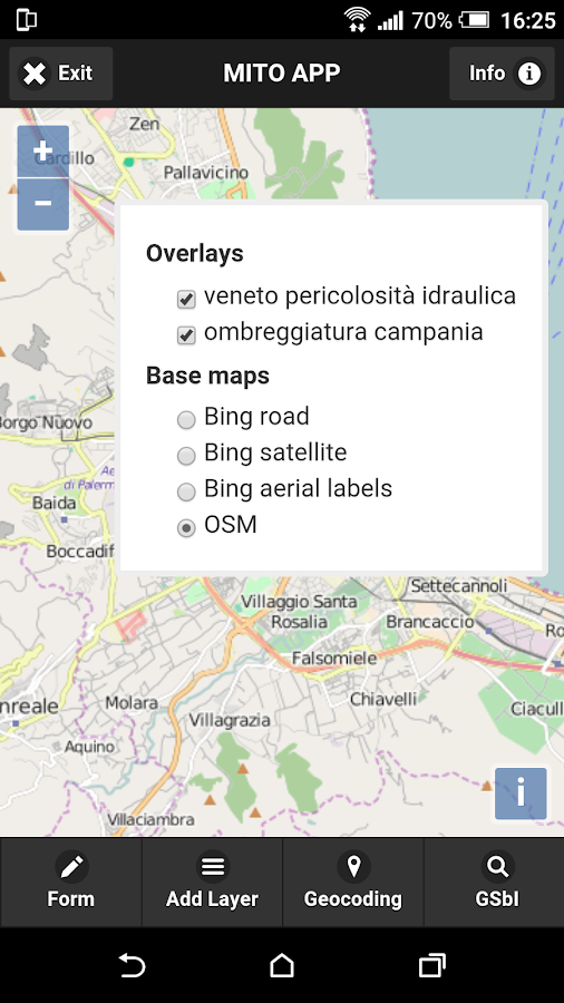
L’App permette in modo semplificato, quindi anche a nontecnici,la gestione e visualizzazione di layer informativi edocumentaliper ambiti tematici di diversa natura presenti sulgeodatabase confunzioni interattive tipiche dei sistemiGIS(attivazione/disattivazione layers, aggiunta/rimozionelayers,identifica proprietà, zoom in/out), il geocoding,l’interrogazionedei dati geo-spaziali su mappa, la possibilità dicambiare le mappedi base, e la localizzazione su mappa dellapropria posizione.
Inoltre è possibile la compilazione di form basati sutemplate,per gli ambiti applicativi specifici: Rischio idraulicoegeomorfologico (allagamenti, frane, erosione), eRepertorioconnesso alla tracciabilità dell’olio di oliva econseguenti rischiper la salute.
With funding from the MITO project, ISPRA and 7 University oftheSouth, including UNIPA, they have managed to create thefirstplatform for the management and exchange of geo-referencedobjects,in service and integration of activities of differentsectors,ranging from the enhancement of cultural heritage,environmentalprotection, land use planning, with particularemphasis devotedacquisition tools and transmission of data andinformation on themove.
The App allows a simplified, so even non-technical,managementand visualization of information and documentary layerfor thematicareas of different nature present in the geodatabasewith uniqueinteractive features of GIS systems (on / off layers,adding /removing layers, identifies properties, zoom in / out),geocoding,querying geospatial data on the map, the ability tochange the basemaps, and location on the map of your location.
It is also possible to compile template-based form, forspecificapplication areas: Hydraulic and geomorphological risk(flooding,landslides, erosion), and Repertory linked to oliveoiltraceability and consequent health risks.